Friendly, West Virginia

Last updated

Friendly, West Virginia
Tyler County West Virginia Incorporated and Unincorporated areas Friendly Highlighted.svg
Location of Friendly in Tyler County, West Virginia.
Coordinates: 39°30′54″N81°3′40″W / 39.51500°N 81.06111°W / 39.51500; -81.06111
Country United States
State West Virginia
County Tyler
Area
[1]
  Total0.10 sq mi (0.26 km2)
  Land0.10 sq mi (0.26 km2)
  Water0.00 sq mi (0.00 km2)
Elevation
627 ft (191 m)
Population
 (2020) [2]
  Total100
  Estimate 
(2021) [2]
98
  Density1,198.02/sq mi (462.73/km2)
Time zone UTC-5 (Eastern (EST))
  Summer (DST) UTC-4 (EDT)
ZIP code
26146
Area code 304
FIPS code 54-29404 [3]
GNIS feature ID1554513 [4]

Friendly is a town in Tyler County, West Virginia, United States. The population was 100 at the 2020 census. [2]

Contents

History

The town was likely named for Friend Cochrane Williamson, an early settler. [5] Friendly was incorporated in 1898. [6]

It is the setting of the novel Shiloh .

The 1884 Heirloom tomato variety was said to be discovered by James Lyde Williamson growing in a pile of flood debris along the Ohio River near Friendly, after the Great Flood of 1884. [7] [8]

In 1903 the Parkersburg and Ohio Valley Electric Railway began to build a major electric interurban railway between Wheeling and Parkersburg. It only opened five miles (8 km) between Sistersville and Friendly, and operated until 1918. Friendly was claimed to have been one of the smallest settlements in the US with a dedicated interurban service, since it only had 217 residents at the time. [9]

The Friendly City Building and Jail has been listed on the National Register of Historic Places.

Geography

Friendly is located at 39°30′54″N81°3′40″W / 39.51500°N 81.06111°W / 39.51500; -81.06111 (39.514888, -81.061011), [10] along the Ohio River; directly across from Matamoras, Ohio. [11]

According to the United States Census Bureau, the town has a total area of 0.09 square miles (0.23 km2), all land. [12]

Demographics

Historical population
CensusPop.Note
1900 253
1910 217−14.2%
1920 173−20.3%
1930 170−1.7%
1940 148−12.9%
1950 21645.9%
1960 195−9.7%
1970 190−2.6%
1980 24227.4%
1990 146−39.7%
2000 1598.9%
2010 132−17.0%
2020 100−24.2%
2021 (est.)98 [2] −2.0%
U.S. Decennial Census [13]

2010 census

As of the census [14] of 2010, there were 132 people, 55 households, and 37 families living in the town. The population density was 1,466.7 inhabitants per square mile (566.3/km2). There were 73 housing units at an average density of 811.1 per square mile (313.2/km2). The racial makeup of the town was 100.0% White.

There were 55 households, of which 27.3% had children under the age of 18 living with them, 45.5% were married couples living together, 10.9% had a female householder with no husband present, 10.9% had a male householder with no wife present, and 32.7% were non-families. 21.8% of all households were made up of individuals, and 3.6% had someone living alone who was 65 years of age or older. The average household size was 2.40 and the average family size was 2.68.

The median age in the town was 47 years. 20.5% of residents were under the age of 18; 7.5% were between the ages of 18 and 24; 17.4% were from 25 to 44; 32.6% were from 45 to 64; and 22% were 65 years of age or older. The gender makeup of the town was 51.5% male and 48.5% female.

2000 census

As of the census [3] of 2000, there were 159 people, 62 households, and 47 families living in the town. The population density was 1,664.3 inhabitants per square mile (613.9/km2). There were 70 housing units at an average density of 732.7 per square mile (270.3/km2). The racial makeup of the town was 99.99% White.

There were 62 households, out of which 30.6% had children under the age of 18 living with them, 64.5% were married couples living together, 11.3% had a female householder with no husband present, and 22.6% were non-families. 19.4% of all households were made up of individuals, and 9.7% had someone living alone who was 65 years of age or older. The average household size was 2.56 and the average family size was 2.83.

In the town, the population was spread out, with 22.0% under the age of 18, 5.0% from 18 to 24, 33.3% from 25 to 44, 25.8% from 45 to 64, and 13.8% who were 65 years of age or older. The median age was 36 years. For every 100 females, there were 91.6 males. For every 100 females age 18 and over, there were 90.8 males.

The median income for a household in the town was $33,571, and the median income for a family was $34,821. Males had a median income of $37,500 versus $15,000 for females. The per capita income for the town was $15,386. About 13.2% of families and 15.0% of the population were below the poverty line, including 12.5% of those under the age of eighteen and 26.7% of those 65 or over.

See also

Related Research Articles

<span class="mw-page-title-main">Bostwick, Georgia</span> City in Georgia, United States

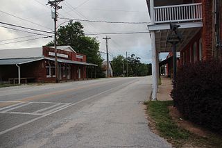
Bostwick is a city in Morgan County, Georgia, United States. As of the 2020 census, the city had a population of 378.

<span class="mw-page-title-main">Flatwoods, West Virginia</span> Town in West Virginia, United States

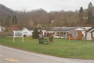
Flatwoods is a town in Braxton County, West Virginia, United States, located approximately one mile from exit 67 of Interstate 79.

<span class="mw-page-title-main">Windsor Heights, West Virginia</span> Village in West Virginia, United States

Windsor Heights is a village in Brooke County, West Virginia, United States. It is part of the Wheeling, West Virginia Metropolitan Statistical Area. The population was 423 at the 2010 census. Grace Davis was the mayor as of June, 2017.

<span class="mw-page-title-main">Handley, West Virginia</span> Town in West Virginia, United States

Handley is a town in Kanawha County, West Virginia, United States. The population was 224 at the 2020 census. Handley was first established in 1877 and known as Upper Creek until July 29, 1881, when its name was changed to Handley for pioneer settlers who farmed the area. Handley has the distinction of bearing a name like no other town in the United States. The town was incorporated November 1972.

<span class="mw-page-title-main">Mitchell Heights, West Virginia</span> Town in West Virginia, United States

Mitchell Heights is a town in Logan County, West Virginia, United States. The population was 315 at the 2020 census. The town was named for an early farm on which it was established.

<span class="mw-page-title-main">Glen Dale, West Virginia</span> Town in West Virginia

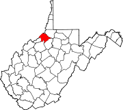
Glen Dale is a city in Marshall County, West Virginia, United States, along the Ohio River. It is part of the Wheeling, West Virginia Metropolitan Statistical Area. The population was 1,514 at the 2020 census. Glen Dale was incorporated in 1924. It is in the northwest part of the county, which is above the Mason–Dixon line and forms the base of the Northern Panhandle of West Virginia.

<span class="mw-page-title-main">McMechen, West Virginia</span> City in West Virginia

McMechen is a city in Marshall County, West Virginia, United States, situated along the Ohio River. It is part of the Wheeling, West Virginia Metropolitan Statistical Area. The population was 1,714 at the 2020 census.

<span class="mw-page-title-main">Hartford City, West Virginia</span> Town in West Virginia, United States

Hartford City, also known as Hartford, is a town in Mason County, West Virginia, United States. The population was 509 at the 2020 census. It is part of the Point Pleasant, WV–OH Micropolitan Statistical Area.

<span class="mw-page-title-main">Mason, West Virginia</span> Town in West Virginia, United States

Mason, also known as Mason City, is a town in Mason County, West Virginia, United States. The population was 865 at the 2020 census. It is part of the Point Pleasant, WV–OH Micropolitan Statistical Area.

<span class="mw-page-title-main">New Haven, West Virginia</span> Town in West Virginia, United States

New Haven is a town in Mason County, West Virginia, United States, along the Ohio River. The population was 1,485 at the 2020 census. It is part of the Point Pleasant, WV–OH Micropolitan Statistical Area.

<span class="mw-page-title-main">Matoaka, West Virginia</span> Census-designated place in West Virginia, United States

Matoaka is a census-designated place in Mercer County, West Virginia, United States. The population was 173 at the 2020 census. It is part of the Bluefield, WV-VA micropolitan area which has a population of 100,093. This town is named for Chief Powhatan's daughter Matoaka who was better known by her nickname "Pocahontas". Matoaka became an unincorporated town when it voted to dissolve its charter in May 2018.

<span class="mw-page-title-main">Clearview, West Virginia</span> Village in West Virginia, United States

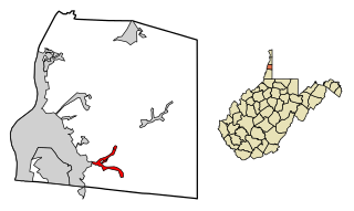
Clearview is a village in Ohio County, West Virginia, United States. It is part of the Wheeling, West Virginia Metropolitan Statistical Area. The population was 565 at the 2010 census.

<span class="mw-page-title-main">Triadelphia, West Virginia</span> Town in West Virginia, United States

Triadelphia is a town in Ohio County, West Virginia, United States. It is part of the Wheeling, West Virginia Metropolitan Statistical Area. The population was 669 at the 2020 census.

<span class="mw-page-title-main">West Liberty, West Virginia</span> Town in West Virginia, United States

West Liberty is a town in Ohio County, West Virginia, United States. The population was 1,557 at the 2020 census. It is part of the Wheeling metropolitan area.

<span class="mw-page-title-main">Belmont, West Virginia</span> Town in West Virginia, United States

Belmont is a town in Pleasants County, West Virginia, United States. It is part of the Parkersburg–Vienna metropolitan area. The population was 872 at the 2020 census. Belmont was incorporated on April 19, 1946, by the Circuit Court of Pleasants County. The city was named for the beautiful hills in the area.

<span class="mw-page-title-main">St. Marys, West Virginia</span> City in West Virginia, United States

St. Marys is a city and the county seat of Pleasants County, West Virginia, United States. The population was 1,847 at the 2020 census. It is part of the Parkersburg–Vienna metropolitan area. St. Marys was established in 1849 by Alexander Creel, who is said to have had a vision of Mary while passing the townsite by boat on the Ohio River.

<span class="mw-page-title-main">Rowlesburg, West Virginia</span> Town in West Virginia, United States

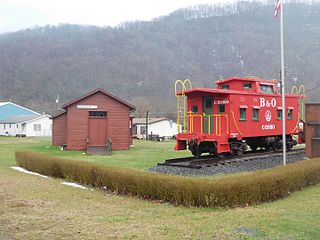
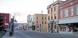
Rowlesburg is a town in southern Preston County, West Virginia, United States, along the Cheat River. The population was 438 at the 2020 census. It is part of the Morgantown metropolitan area. A former railroad town, it is home to the Downtown Rowlesburg Historic District, and was the site of action during the American Civil War.

<span class="mw-page-title-main">Tunnelton, West Virginia</span> Town in West Virginia, United States

Tunnelton is a town in southwestern Preston County, West Virginia, United States. The population was 307 at the 2020 census. It is part of the Morgantown metropolitan area.

<span class="mw-page-title-main">Ellenboro, West Virginia</span> Town in West Virginia, United States

Ellenboro is a town in Ritchie County, West Virginia, United States. The population was 222 at the 2020 census. The town is located at the junction of U.S. Route 50 and West Virginia Route 16; the North Bend Rail Trail also passes through the town. The town was named for Ellen Mariah Williamson, the eldest daughter of the family that granted a right of way for the Baltimore and Ohio Railroad to build their line through the town; an earlier name for the community was Shumley. Ellenboro was incorporated in 1903.

<span class="mw-page-title-main">Cowen, West Virginia</span> Town in West Virginia, United States

Cowen is a town in Webster County, West Virginia, United States. The population was 488 at the 2020 census.

References

  1. "2019 U.S. Gazetteer Files". United States Census Bureau. Retrieved August 7, 2020.
  2. 1 2 3 4 Bureau, US Census. "City and Town Population Totals: 2020-2021". Census.gov. US Census Bureau. Retrieved July 2, 2022.
  3. 1 2 "U.S. Census website". United States Census Bureau . Retrieved January 31, 2008.
  4. "US Board on Geographic Names". United States Geological Survey. October 25, 2007. Retrieved January 31, 2008.
  5. Kenny, Hamill (1945). West Virginia Place Names: Their Origin and Meaning, Including the Nomenclature of the Streams and Mountains. Piedmont, WV: The Place Name Press. p. 255.
  6. West Virginia Blue Book. Published annually by the Clerk's Office of the West Virginia Senate.
  7. "1884 og".
  8. http://store.tomatofest.com/ProductDetails.asp?ProductCode=TF-0002. Archived August 9, 2013, at the Wayback Machine
  9. Hilton & Due: The Electric Interurban Railways in America Stamford University Press 1960 p. 305
  10. "US Gazetteer files: 2010, 2000, and 1990". United States Census Bureau. February 12, 2011. Retrieved April 23, 2011.
  11. West Virginia Atlas & Gazetteer. Yarmouth, Me.: DeLorme. 1997. p. 23. ISBN   0-89933-246-3.
  12. "US Gazetteer files 2010". United States Census Bureau. Archived from the original on July 2, 2012. Retrieved January 24, 2013.
  13. "Census of Population and Housing". Census.gov. Retrieved June 4, 2015.
  14. "U.S. Census website". United States Census Bureau . Retrieved January 24, 2013.