Lumberport, West Virginia

Last updated

Lumberport, West Virginia
Lumberport West Virginia.jpg
Main Street (West Virginia Route 20) in Lumberport in 2006
Seal of Lumberport, West Virginia.svg
Harrison County West Virginia Incorporated and Unincorporated areas Lumberport Highlighted.svg
Location of Lumberport in Harrison County, West Virginia.
Coordinates: 39°22′30″N80°20′54″W / 39.37500°N 80.34833°W / 39.37500; -80.34833
Country United States
State West Virginia
County Harrison
Area
[1]
  Total0.50 sq mi (1.30 km2)
  Land0.50 sq mi (1.30 km2)
  Water0.00 sq mi (0.00 km2)
Elevation
925 ft (282 m)
Population
 (2020) [2]
  Total720
  Estimate 
(2021) [2]
710
  Density1,669.98/sq mi (644.40/km2)
Time zone UTC-5 (Eastern (EST))
  Summer (DST) UTC-4 (EDT)
ZIP code
26386
Area code 304
FIPS code 54-49252 [3]
GNIS feature ID1542612 [4]

Lumberport is a town in Harrison County, located in northern West Virginia, United States. The population was 720 at the 2020 census. [2]

Contents

The rural town was so named on account of the extensive lumber industry conducted there in the early 20th century. [5] With changes in the lumber industry, the number of jobs declined, leading to a loss in population after the 1950s.

Geography

Lumberport is located at 39°22′30″N80°20′54″W / 39.37500°N 80.34833°W / 39.37500; -80.34833 (39.375041, -80.348213), [6] at the confluence of Tenmile Creek and the West Fork River in northern Harrison County. [7]

According to the United States Census Bureau, the town has a total area of 0.50 square miles (1.29 km2), all land. [8]

Demographics

Historical population
CensusPop.Note
1910 656
1920 90037.2%
1930 1,29844.2%
1940 1,285−1.0%
1950 1,198−6.8%
1960 1,031−13.9%
1970 957−7.2%
1980 939−1.9%
1990 1,0148.0%
2000 937−7.6%
2010 876−6.5%
2020 720−17.8%
2021 (est.)710 [2] −1.4%
U.S. Decennial Census [9]

2010 census

As of the census of 2010, [10] there were 876 people, 350 households, and 241 families living in the town. There were 384 housing units. The racial makeup of the town was 98.4% White, 0.5% African American, 0% Native American, 0% Asian, and 0.9% from two or more races. Hispanic or Latino of any race were 1.0% of the population.

There were 350 households, of which 32.6% had children under the age of 18 living with them, 49.7% were married couples living together, 14.6% had a female householder with no husband present, and 31.1% were non-families. 32.6% of all households had individuals under 18 years and 30.0% had someone who was 65 years of age or older. The average household size was 2.50 and the average family size was 3.01.

In the town, the population was spread out, with 26.3% under the age of 20, 31.8% from 20 to 44, 27.2% from 45 to 64, and 14.8% who were 65 years of age or older. The median age was 39.8 years. 50.8 percent of the population was male and 49.2 female.

The median income for a household in the town was $38,625, and the median income for a family was $44,231. The per capita income for the town was $19,710. About 11.0% of the population was below the poverty line, including 14.1% of those under age 18 and 6% of those age 65 or over.

2000 census

As of the census [3] of 2000, there were 937 people, 353 households, and 273 families living in the town. The population density was 1,855.1 inhabitants per square mile (709.4/km2). There were 388 housing units at an average density of 768.2 per square mile (293.7/km2). The racial makeup of the town was 98.93% White, 0.43% African American, 0.32% Native American, 0.11% Asian, and 0.21% from two or more races. Hispanic or Latino of any race were 0.21% of the population.

There were 353 households, out of which 33.7% had children under the age of 18 living with them, 58.1% were married couples living together, 14.4% had a female householder with no husband present, and 22.4% were non-families. 21.8% of all households were made up of individuals, and 9.9% had someone living alone who was 65 years of age or older. The average household size was 2.63 and the average family size was 3.03.

In the town, the population was spread out, with 26.6% under the age of 18, 6.1% from 18 to 24, 29.9% from 25 to 44, 22.4% from 45 to 64, and 15.0% who were 65 years of age or older. The median age was 37 years. For every 100 females, there were 92.0 males. For every 100 females age 18 and over, there were 85.4 males.

The median income for a household in the town was $33,750, and the median income for a family was $38,462. Males had a median income of $27,500 versus $21,719 for females. The per capita income for the town was $13,904. About 8.7% of families and 12.8% of the population were below the poverty line, including 17.8% of those under age 18 and 10.1% of those age 65 or over.

Related Research Articles

<span class="mw-page-title-main">Pine Castle, Florida</span> Census-designated place in Florida, United States

Pine Castle is a census-designated place and unincorporated area in Orange County, Florida, United States. It is part of the Orlando–Kissimmee–Sanford, Florida Metropolitan Statistical Area.

<span class="mw-page-title-main">Culdesac, Idaho</span> City in Idaho, United States

Culdesac is a city in Nez Perce County, Idaho, United States. The population was 380 at the 2010 census. It is part of the Lewiston, ID-WA Metropolitan Statistical Area.

<span class="mw-page-title-main">Cedarville, Illinois</span> Village in Illinois, United States

Cedarville is a village in Stephenson County, Illinois, United States. The population was 741 at the 2010 census, up from 719 in 2000. It is the birthplace of social activist Jane Addams, the 1931 Nobel Peace Prize winner.

<span class="mw-page-title-main">Carrsville, Kentucky</span> City in Kentucky, United States

Carrsville is a home rule-class city beside the Ohio River in Livingston County, Kentucky, in the United States. The population was 50 at the 2010 census, declining from 64 as of 2000. It is part of the Paducah, KY-IL Metropolitan Statistical Area. It is situated just west of the junction of where Buck Creek empties into the Ohio River.

<span class="mw-page-title-main">Valley, Nebraska</span> City in Douglas County, Nebraska, United States

Valley is a city in Douglas County, Nebraska, United States. The population was 3,037 at the 2020 census.

<span class="mw-page-title-main">Butler Township, Schuylkill County, Pennsylvania</span> Township in Pennsylvania, United States

Butler Township is a township in Schuylkill County, Pennsylvania, United States. Formed in 1848 from part of Barry Township, it is named for war hero William Orlando Butler.

<span class="mw-page-title-main">Braden, Tennessee</span> Town in Tennessee, United States

Braden is a town in Fayette County, Tennessee. The population was 282 at the 2010 census. The town is named after Joseph P. Braden.

<span class="mw-page-title-main">West Milford, West Virginia</span> Town in West Virginia, United States

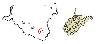
West Milford is a town in Harrison County, West Virginia, United States. The population was 452 at the 2020 census.

<span class="mw-page-title-main">White Hall, West Virginia</span> Town in West Virginia, United States

White Hall is a town in Marion County, West Virginia, United States. The population was 706 at the 2020 census. Incorporated in 1989, White Hall is adjacent to the county seat, Fairmont, and is part of the Fairmont, West Virginia, Micropolitan Statistical Area. White Hall has many different stores and restaurants.

<span class="mw-page-title-main">Worthington, West Virginia</span> Town in West Virginia, United States

Worthington is a town in Marion County, West Virginia, United States. The population was 158 at the 2010 census. Worthington was incorporated in 1893 and named for Colonel George Worthington, an early settler. U.S. Route 19 passes through the town.

<span class="mw-page-title-main">Granville, West Virginia</span> Town in West Virginia

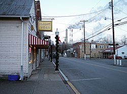
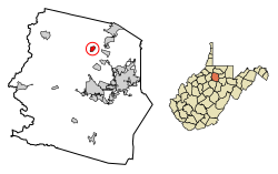
Granville is a town in Monongalia County, West Virginia, United States. The population was 1,355 at the 2020 census. It is included in the Morgantown metropolitan area.

<span class="mw-page-title-main">Brandonville, West Virginia</span> Town in West Virginia, United States

Brandonville is a town in northern Preston County, West Virginia, United States. The population was 136 at the 2020 census. It is part of the Morgantown metropolitan area.

<span class="mw-page-title-main">Reedsville, West Virginia</span> Town in West Virginia, United States

Reedsville is a town in western Preston County, West Virginia, United States. The population was 530 at the 2020 census. It is part of the Morgantown metropolitan area.

<span class="mw-page-title-main">Ellenboro, West Virginia</span> Town in West Virginia, United States

Ellenboro is a town in Ritchie County, West Virginia, United States. The population was 222 at the 2020 census. The town is located at the junction of U.S. Route 50 and West Virginia Route 16; the North Bend Rail Trail also passes through the town. The town was named for Ellen Mariah Williamson, the eldest daughter of the family that granted a right of way for the Baltimore and Ohio Railroad to build their line through the town; an earlier name for the community was Shumley. Ellenboro was incorporated in 1903.

<span class="mw-page-title-main">Pullman, West Virginia</span> Town in West Virginia, United States

Pullman is a town in Ritchie County, West Virginia, United States. The population was 134 at the 2020 census.

<span class="mw-page-title-main">Flemington, West Virginia</span> Town in West Virginia, United States

Flemington is a town in Taylor County, West Virginia, United States. The population was 311 at the 2020 census. Flemington was incorporated in 1922 by the West Virginia Circuit Court, and named for James Fleming, an early settler in the area originally from Hampshire County.

<span class="mw-page-title-main">Camden-on-Gauley, West Virginia</span> Town in West Virginia, United States

Camden-on-Gauley is a town in Webster County, West Virginia, United States, along the Gauley River. The population was 126 at the 2020 census.

<span class="mw-page-title-main">Pine Grove, West Virginia</span> Town in West Virginia, United States

Pine Grove is a town in Wetzel County, West Virginia, United States. The population was 363 at the 2020 census. The community was named for a grove of pine trees near the original town site.

<span class="mw-page-title-main">Smithfield, West Virginia</span> Town in West Virginia, United States

Smithfield is a town in Wetzel County, West Virginia, United States. The population was 103 at the 2020 census.

<span class="mw-page-title-main">Greentop, Missouri</span> City in Missouri, United States

Greentop is a city in Adair and Schuyler counties, Missouri, United States. As of the 2020 census, its population was 388.

References

  1. "2019 U.S. Gazetteer Files". United States Census Bureau. Retrieved August 7, 2020.
  2. 1 2 3 4 Bureau, US Census. "City and Town Population Totals: 2020-2021". Census.gov. US Census Bureau. Retrieved July 2, 2022.
  3. 1 2 "U.S. Census website". United States Census Bureau . Retrieved January 31, 2008.
  4. "US Board on Geographic Names". United States Geological Survey. October 25, 2007. Retrieved January 31, 2008.
  5. Kenny, Hamill (1945). West Virginia Place Names: Their Origin and Meaning, Including the Nomenclature of the Streams and Mountains. Piedmont, WV: The Place Name Press. p. 389.
  6. "US Gazetteer files: 2010, 2000, and 1990". United States Census Bureau. February 12, 2011. Retrieved April 23, 2011.
  7. DeLorme (1997). West Virginia Atlas & Gazetteer. Yarmouth, Maine: DeLorme. p.25. ISBN   0-89933-246-3.
  8. "US Gazetteer files 2010". United States Census Bureau. Archived from the original on January 25, 2012. Retrieved January 24, 2013.
  9. "Census of Population and Housing". Census.gov. Retrieved June 4, 2015.
  10. "2010 Census Data".