Granville, West Virginia

Last updated

Granville, West Virginia
Sunset on Granville, West Virginia (34384406002).jpg
Sunset in April 2017
Seal of Granville, West Virginia.svg
Logo of Granville, West Virginia.svg
Monongalia County West Virginia Incorporated and Unincorporated areas Granville Highlighted.svg
Location of Granville in Monongalia County, West Virginia.
Coordinates: 39°38′36″N79°59′17″W / 39.64333°N 79.98806°W / 39.64333; -79.98806
Country Flag of the United States.svg  United States
State Flag of West Virginia.svg  West Virginia
County Flag of Monongalia County, West Virginia.svg Monongalia
Area
[1]
  Total1.30 sq mi (3.36 km2)
  Land1.30 sq mi (3.36 km2)
  Water0.00 sq mi (0.00 km2)
Elevation
[2]
814 ft (248 m)
Population
 (2020) [3]
  Total1,355
  Estimate 
(2021) [3]
1,390
  Density2,420.97/sq mi (934.55/km2)
Time zone UTC-5 (Eastern (EST))
  Summer (DST) UTC-4 (EDT)
ZIP code
26534
Area code 304
FIPS code 54-32932
GNIS feature ID1539594 [2]
Website https://townofgranvillewv.gov/

Granville is a town in Monongalia County, West Virginia, United States. The population was 1,355 at the 2020 census. [4] It is included in the Morgantown metropolitan area.

Contents

History

Granville was originally called Grandville, after a nearby river island. [5]

Geography

Granville is located at 39°38′36″N79°59′17″W / 39.64333°N 79.98806°W / 39.64333; -79.98806 (39.643426, -79.988054). [6]

According to the United States Census Bureau, the town has a total area of 1.30 square miles (3.37 km2), all land. [7]

Demographics

Historical population
CensusPop.Note
1880 122
1950 1,004
1960 806−19.7%
1970 97120.5%
1980 9922.2%
1990 791−20.3%
2000 778−1.6%
2010 7810.4%
2020 1,35573.5%
2021 (est.)1,390 [3] 2.6%
U.S. Decennial Census [8]

2010 census

As of the census [9] of 2010, there were 781 people, 356 households, and 195 families living in the town. The population density was 600.8 inhabitants per square mile (232.0/km2). There were 394 housing units at an average density of 303.1 per square mile (117.0/km2). The racial makeup of the town was 95.3% White, 1.9% African American, 0.1% Asian, and 2.7% from two or more races. Hispanic or Latino of any race were 1.3% of the population.

There were 356 households, of which 27.2% had children under the age of 18 living with them, 33.4% were married couples living together, 17.1% had a female householder with no husband present, 4.2% had a male householder with no wife present, and 45.2% were non-families. 36.8% of all households were made up of individuals, and 14.4% had someone living alone who was 65 years of age or older. The average household size was 2.19 and the average family size was 2.88.

The median age in the town was 40.8 years. 20% of residents were under the age of 18; 9.1% were between the ages of 18 and 24; 26.6% were from 25 to 44; 28.9% were from 45 to 64; and 15.4% were 65 years of age or older. The gender makeup of the town was 46.2% male and 53.8% female.

2000 census

As of the census of 2000, there were 778 people, 362 households, and 201 families living in the town. The population density was 592.2 inhabitants per square mile (229.3/km2). There were 430 housing units at an average density of 327.3 per square mile (126.7/km2). The racial makeup of the town was 95.89% White, 2.06% African American, 0.51% Native American, 0.39% Asian, and 1.16% from two or more races. Hispanic or Latino of any race were 0.51% of the population.

There were 362 households, out of which 24.0% had children under the age of 18 living with them, 34.0% were married couples living together, 18.2% had a female householder with no husband present, and 44.2% were non-families. 37.6% of all households were made up of individuals, and 16.3% had someone living alone who was 65 years of age or older. The average household size was 2.15 and the average family size was 2.81.

In the town, the population was spread out, with 20.7% under the age of 18, 10.2% from 18 to 24, 30.2% from 25 to 44, 23.5% from 45 to 64, and 15.4% who were 65 years of age or older. The median age was 36 years. For every 100 females, there were 82.2 males. For every 100 females age 18 and over, there were 78.3 males.

The median income for a household in the town was $22,583, and the median income for a family was $26,806. Males had a median income of $21,250 versus $17,212 for females. The per capita income for the town was $12,958. About 25.4% of families and 27.7% of the population were below the poverty line, including 43.4% of those under age 18 and 8.7% of those age 65 or over.

Notable person

Climate

The climate in this area has mild differences between highs and lows, and there is adequate rainfall year-round. According to the Köppen Climate Classification system, Granville has a subtropical highland climate, abbreviated "Cfb" on climate maps. [10]

Related Research Articles

<span class="mw-page-title-main">Columbus, Illinois</span> Village in Illinois, United States

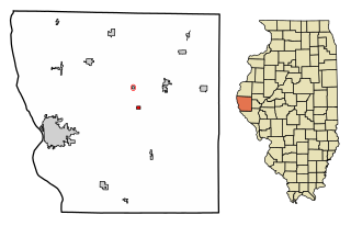
Columbus is a village in Adams County, Illinois, United States. The population was 114 at the 2020 census. It is part of the Quincy, IL–MO Micropolitan Statistical Area.

<span class="mw-page-title-main">Hartford, Maine</span> Town in the state of Maine, United States

Hartford is a town in Oxford County, Maine, United States. Hartford is included in the Lewiston-Auburn, Maine metropolitan New England City and Town Area. The population was 1,203 at the 2020 census.

<span class="mw-page-title-main">Licking Creek Township, Fulton County, Pennsylvania</span> Township in Pennsylvania, United States

Licking Creek Township is a township in Fulton County, Pennsylvania, United States. The population was 1,576 at the 2020 census.

<span class="mw-page-title-main">Petersburg, West Virginia</span> City in West Virginia, United States

Petersburg is a city in Grant County, West Virginia, United States. The population was 2,251 at the 2020 census. It is the county seat of Grant County.

<span class="mw-page-title-main">Nutter Fort, West Virginia</span> Town in West Virginia, United States

Nutter Fort is a town in Harrison County, West Virginia, United States, incorporated in 1923. The town is a southeastern suburb of Clarksburg.

<span class="mw-page-title-main">Jane Lew, West Virginia</span> Town in West Virginia, United States

Jane Lew is a town in Lewis County, West Virginia, United States. The population was 409 at the time of the 2020 census.

<span class="mw-page-title-main">Barrackville, West Virginia</span> Town in West Virginia, United States

Barrackville is a town in Marion County, West Virginia, United States. The population was 1,211 at the 2020 census.

<span class="mw-page-title-main">Northfork, West Virginia</span> Town in West Virginia, United States

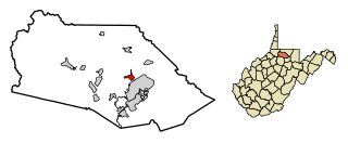
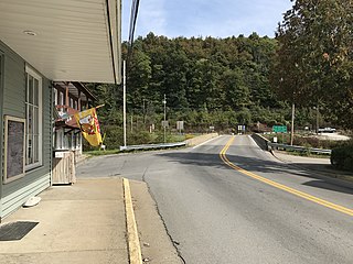
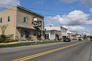
Northfork is a town in McDowell County, West Virginia, United States, located on U.S. Route 52 between Welch and Bluefield.

<span class="mw-page-title-main">Oakvale, West Virginia</span> Town in West Virginia, United States

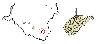
Oakvale is a town in Mercer County, West Virginia, United States, along the East River. The population was 137 at the 2020 census. It is part of the Bluefield, WV-VA micropolitan area which has a population of 107,578.

<span class="mw-page-title-main">Bruceton Mills, West Virginia</span> Town in West Virginia, United States

Bruceton Mills is a town in northern Preston County, West Virginia, United States, along Big Sandy Creek. The population was 64 at the 2020 census, making it the second-least populous town in West Virginia, after Thurmond. It is part of the Morgantown metropolitan area.

<span class="mw-page-title-main">Rowlesburg, West Virginia</span> Town in West Virginia, United States

Rowlesburg is a town in southern Preston County, West Virginia, United States, along the Cheat River. The population was 438 at the 2020 census. It is part of the Morgantown metropolitan area. A former railroad town, it is home to the Downtown Rowlesburg Historic District, and was the site of action during the American Civil War.

<span class="mw-page-title-main">Terra Alta, West Virginia</span> Town in West Virginia, United States

Terra Alta is a town in eastern Preston County, West Virginia, United States. The population was 1,415 at the 2020 census. It is part of the Morgantown metropolitan area.

<span class="mw-page-title-main">Cairo, West Virginia</span> Town in West Virginia, United States

Cairo is a town in Ritchie County, West Virginia, United States, along West Virginia Route 31, the North Fork of the Hughes River, and the North Bend Rail Trail. The population was 174 at the 2020 census.

<span class="mw-page-title-main">Davis, West Virginia</span> Town in West Virginia, United States

Davis is a town in Tucker County, West Virginia, United States, situated along the Blackwater River. The population was 595 at the 2020 census.

<span class="mw-page-title-main">Hambleton, West Virginia</span> Town in West Virginia, United States

Hambleton is a town in Tucker County, West Virginia, United States. The population was 216 at the 2020 census. Hambleton was established in 1889, but not incorporated until 1905. It was named by then United States Senator Stephen B. Elkins in honor of a stockholder by this name in the West Virginia Central Railroad Company. The town was previously known as Hulings.

<span class="mw-page-title-main">Middlebourne, West Virginia</span> Town in West Virginia, United States

Middlebourne is a town and the county seat of Tyler County, West Virginia, United States. The population was 715 at the 2020 census.

<span class="mw-page-title-main">Camden-on-Gauley, West Virginia</span> Town in West Virginia, United States

Camden-on-Gauley is a town in Webster County, West Virginia, United States, along the Gauley River. The population was 126 at the 2020 census.

<span class="mw-page-title-main">New Martinsville, West Virginia</span> City in West Virginia, United States

New Martinsville is a city in and the county seat of Wetzel County, West Virginia, United States, along the Ohio River. The population was 5,186 at the 2020 census.

<span class="mw-page-title-main">Smithfield, West Virginia</span> Town in West Virginia, United States

Smithfield is a town in Wetzel County, West Virginia, United States. The population was 103 at the 2020 census.

<span class="mw-page-title-main">Elizabeth, West Virginia</span> Town in West Virginia, United States

Elizabeth is a town in and the county seat of Wirt County, West Virginia, United States, situated along the Little Kanawha River. The population was 724 as of the 2020 census.

References

  1. "2019 U.S. Gazetteer Files". United States Census Bureau. Retrieved August 7, 2020.
  2. 1 2 U.S. Geological Survey Geographic Names Information System: Granville, West Virginia
  3. 1 2 3 "City and Town Population Totals: 2020-2021". Census.gov. US Census Bureau. Retrieved July 3, 2022.
  4. "U.S. Census website". United States Census Bureau . Retrieved December 2, 2022.
  5. Kenny, Hamill (1945). West Virginia Place Names: Their Origin and Meaning, Including the Nomenclature of the Streams and Mountains. Piedmont, WV: The Place Name Press. p. 281.
  6. "US Gazetteer files: 2010, 2000, and 1990". United States Census Bureau. February 12, 2011. Retrieved April 23, 2011.
  7. "US Gazetteer files 2010". United States Census Bureau. Archived from the original on January 25, 2012. Retrieved January 24, 2013.
  8. "U.S. Decennial Census". Census.gov. Retrieved June 11, 2013.
  9. "U.S. Census website". United States Census Bureau . Retrieved January 24, 2013.
  10. Climate Summary for Granville, West Virginia