Auburn, West Virginia

Last updated

Auburn, West Virginia
Ritchie County West Virginia Incorporated and Unincorporated areas Auburn Highlighted.svg
Location of Auburn in Ritchie County, West Virginia.
Coordinates: 39°5′44″N80°51′24″W / 39.09556°N 80.85667°W / 39.09556; -80.85667
Country United States
State West Virginia
County Ritchie
Government
  MayorRobert Lowther
Area
[1]
  Total0.34 sq mi (0.87 km2)
  Land0.34 sq mi (0.87 km2)
  Water0.00 sq mi (0.00 km2)
Elevation
827 ft (252 m)
Population
 (2020) [2]
  Total80
  Estimate 
(2021) [2]
79
  Density262.69/sq mi (101.51/km2)
Time zone UTC-5 (Eastern (EST))
  Summer (DST) UTC-4 (EDT)
ZIP code
26325
Area code 304
FIPS code 54-03364 [3]
GNIS feature ID1553764 [4]
Website https://local.wv.gov/Auburn/Pages/default.aspx

Auburn is a town in Ritchie County, West Virginia, United States. The population was 80 at the 2020 census. [2]

Contents

Geography

Auburn is located at 39°5′44″N80°51′24″W / 39.09556°N 80.85667°W / 39.09556; -80.85667 (39.095430, -80.856538), [5] in the east south-east corner of Ritchie County.

According to the United States Census Bureau, the town has a total area of 0.34 square miles (0.88 km2), all land. [6]

Demographics

Historical population
CensusPop.Note
1880 109
1910 199
1920 177−11.1%
1930 166−6.2%
1940 1681.2%
1950 149−11.3%
1960 139−6.7%
1970 115−17.3%
1980 1160.9%
1990 89−23.3%
2000 10315.7%
2010 97−5.8%
2020 80−17.5%
2021 (est.)79 [2] −1.2%
U.S. Decennial Census [7]

2010 census

As of the census [8] of 2010, there were 97 people, 45 households, and 27 families living in the town. The population density was 285.3 inhabitants per square mile (110.2/km2). There were 56 housing units at an average density of 164.7 per square mile (63.6/km2). The racial makeup of the town was 100.0% White.

There were 45 households, of which 31.1% had children under the age of 18 living with them, 40.0% were married couples living together, 13.3% had a female householder with no husband present, 6.7% had a male householder with no wife present, and 40.0% were non-families. 40.0% of all households were made up of individuals, and 6.6% had someone living alone who was 65 years of age or older. The average household size was 2.16 and the average family size was 2.85.

The median age in the town was 41.5 years. 23.7% of residents were under the age of 18; 7.2% were between the ages of 18 and 24; 22.7% were from 25 to 44; 33.9% were from 45 to 64; and 12.4% were 65 years of age or older. The gender makeup of the town was 49.5% male and 50.5% female.

2000 census

As of the census [3] of 2000, there were 103 people, 41 households, and 31 families living in the town. The population density was 308.0 inhabitants per square mile (119.2/km2). There were 48 housing units at an average density of 143.5 per square mile (56.2/km2). The racial makeup of the town was 99.03% White and 0.97% Asian.

There were 40 households, out of which 40.0% had children under the age of 18 living with them, 47.5% were married couples living together, 17.5% had a female householder with no husband present, and 20.0% were non-families. 17.5% of all households were made up of individuals, and 7.5% had someone living alone who was 65 years of age or older. The average household size was 2.58 and the average family size was 2.88.

In the town, the population was spread out, with 24.3% under the age of 18, 9.7% from 18 to 24, 28.2% from 25 to 44, 26.2% from 45 to 64, and 11.7% who were 65 years of age or older. The median age was 37 years. For every 100 females, there were 114.6 males. For every 100 females age 18 and over, there were 95.0 males.

The median income for a household in the town was $19,063, and the median income for a family was $19,375. Males had a median income of $21,250 versus $13,750 for females. The per capita income for the town was $8,548. There were 32.4% of families and 34.3% of the population living below the poverty line, including 52.4% of under eighteens and none of those over 64.

Approximately 25% of the population reports German ancestry, 13% English, 9% Irish, 1% Canadian and 1% Japanese.

Related Research Articles

Plymouth is a town in Penobscot County, Maine, United States. The population was 1,325 at the 2020 census.

Charlotte is a town in Washington County, Maine, United States. The town was named for the wife of legislator William Vance. The population was 337 at the 2020 census.

Meddybemps is a town in Washington County, Maine, United States. The population was 139 at the 2020 census.

<span class="mw-page-title-main">Derma, Mississippi</span> Town in Mississippi, United States

Derma is a town in Calhoun County, Mississippi, United States. The population was 1,025 at the 2010 census.

<span class="mw-page-title-main">Emsworth, Pennsylvania</span> Borough in Allegheny County, Pennsylvania, United States

Emsworth is a borough in Allegheny County, Pennsylvania, United States, along the Ohio River. The population was 2,525 at the 2020 census.

<span class="mw-page-title-main">New Falcon, Texas</span> CDP in Texas, United States

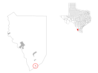
New Falcon is a census-designated place (CDP) in Zapata County, Texas, United States. The population was 191 at the 2010 census.

<span class="mw-page-title-main">Keokee, Virginia</span> Census-designated place in Virginia, United States

Keokee is an unincorporated community and census-designated place (CDP) in Lee County, Virginia, United States. The population was 416 at the 2010 census.

<span class="mw-page-title-main">Sand Fork, West Virginia</span> Town in West Virginia, United States

Sand Fork is a town in Gilmer County, West Virginia, United States. The population was 182 at the 2020 census. It is located along the Little Kanawha River, at the mouth of the Sand Fork.

<span class="mw-page-title-main">Worthington, West Virginia</span> Town in West Virginia, United States

Worthington is a town in Marion County, West Virginia, United States. The population was 158 at the 2010 census. Worthington was incorporated in 1893 and named for Colonel George Worthington, an early settler. U.S. Route 19 passes through the town.

<span class="mw-page-title-main">Peterstown, West Virginia</span> Town in West Virginia, United States

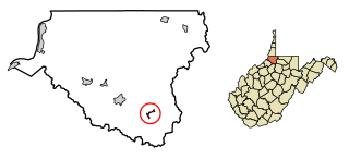
Peterstown is a town in Monroe County, West Virginia, United States. The population was 456 at the 2020 census.

<span class="mw-page-title-main">West Liberty, West Virginia</span> Town in West Virginia, United States

West Liberty is a town in Ohio County, West Virginia, United States. The population was 1,557 at the 2020 census. It is part of the Wheeling metropolitan area.

<span class="mw-page-title-main">Harman, West Virginia</span> Town in West Virginia, United States

Harman is a town in Randolph County, West Virginia, United States. The population was 96 at the 2020 census.

<span class="mw-page-title-main">Pennsboro, West Virginia</span> City in West Virginia, United States

Pennsboro is a city in Ritchie County, West Virginia, United States. The population was 1,050 at the 2020 census. The city is located at the junction of U.S. Route 50 and West Virginia Route 74; the North Bend Rail Trail also passes through the city.

<span class="mw-page-title-main">Pullman, West Virginia</span> Town in West Virginia, United States

Pullman is a town in Ritchie County, West Virginia, United States. The population was 134 at the 2020 census.

<span class="mw-page-title-main">Flemington, West Virginia</span> Town in West Virginia, United States

Flemington is a town in Taylor County, West Virginia, United States. The population was 311 at the 2020 census. Flemington was incorporated in 1922 by the West Virginia Circuit Court, and named for James Fleming, an early settler in the area originally from Hampshire County.

<span class="mw-page-title-main">Camden-on-Gauley, West Virginia</span> Town in West Virginia, United States

Camden-on-Gauley is a town in Webster County, West Virginia, United States, along the Gauley River. The population was 126 at the 2020 census.

<span class="mw-page-title-main">Smithfield, West Virginia</span> Town in West Virginia, United States

Smithfield is a town in Wetzel County, West Virginia, United States. The population was 103 at the 2020 census.

<span class="mw-page-title-main">Potter, Wisconsin</span> Village in Wisconsin, United States

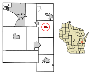
Potter is a village in Calumet County in the U.S. state of Wisconsin. The population was 253 at the 2010 census.

Dallas is a town in Barron County in the U.S. state of Wisconsin. As of the 2010 census, the town had a population of 565. The Village of Dallas is within the town.

Wilton is a town in Monroe County, Wisconsin, United States. The population was 925 at the 2000 census. The Village of Wilton is located partially within the town.

References

  1. "2019 U.S. Gazetteer Files". United States Census Bureau. Retrieved August 7, 2020.
  2. 1 2 3 4 Bureau, US Census. "City and Town Population Totals: 2020-2021". Census.gov. US Census Bureau. Retrieved July 3, 2022.
  3. 1 2 "U.S. Census website". United States Census Bureau . Retrieved January 31, 2008.
  4. "US Board on Geographic Names". United States Geological Survey. October 25, 2007. Retrieved January 31, 2008.
  5. "US Gazetteer files: 2010, 2000, and 1990". United States Census Bureau. February 12, 2011. Retrieved April 23, 2011.
  6. "US Gazetteer files 2010". United States Census Bureau. Archived from the original on January 12, 2012. Retrieved January 24, 2013.
  7. "Census of Population and Housing". Census.gov. Retrieved June 4, 2015.
  8. "U.S. Census website". United States Census Bureau . Retrieved January 24, 2013.