Iaeger, West Virginia

Last updated

Iaeger, West Virginia
Iaeger WV street scene.jpg
Iaeger West Virginia 2017
McDowell County West Virginia Incorporated and Unincorporated areas Iaeger Highlighted.svg
Location of Iaeger in McDowell County, West Virginia.
USA West Virginia location map.svg
Red pog.svg
Iaeger, West Virginia
Usa edcp location map.svg
Red pog.svg
Iaeger, West Virginia
Coordinates: 37°28′1″N81°48′31″W / 37.46694°N 81.80861°W / 37.46694; -81.80861
Country United States
State West Virginia
County McDowell
Area
[1]
  Total0.84 sq mi (2.16 km2)
  Land0.79 sq mi (2.05 km2)
  Water0.04 sq mi (0.11 km2)
Elevation
984 ft (300 m)
Population
 (2020)
  Total257
  Density305.56/sq mi (117.98/km2)
Time zone UTC-5 (Eastern (EST))
  Summer (DST) UTC-4 (EDT)
ZIP code
24844
Area code 304
FIPS code 54-39652 [2]
GNIS feature ID1540647 [3]
Website https://local.wv.gov/iaeger/Pages/default.aspx

Iaeger (pronounced YAY-ger) is a town in McDowell County, West Virginia, United States. The population was 257 at the 2020 census. [4]

Contents

History

Iaeger was incorporated in 1917 and named for Colonel William G. W. Iaeger, an early settler. [5]

Geography

According to the United States Census Bureau, the town has a total area of 0.83 square miles (2.15 km2), of which 0.79 square miles (2.05 km2) is land and 0.04 square miles (0.10 km2) is water. [6]

A junction of the Norfolk Southern Railway is located in Iaeger.

It is the westernmost town in McDowell County.

Climate

The climate in this area is characterized by hot, humid summers and generally mild to cool winters. According to the Köppen Climate Classification system, Iaeger has a humid subtropical climate, abbreviated "Cfa" on climate maps. [7]

Demographics

Historical population
CensusPop.Note
1920 481
1930 1,066121.6%
1940 986−7.5%
1950 1,27128.9%
1960 930−26.8%
1970 822−11.6%
1980 8331.3%
1990 551−33.9%
2000 358−35.0%
2010 302−15.6%
2020 257−14.9%
U.S. Decennial Census [8]

2010 census

As of the census [9] of 2010, there were 302 people, 131 households, and 83 families living in the town. The population density was 382.3 inhabitants per square mile (147.6/km2). There were 167 housing units at an average density of 211.4 per square mile (81.6/km2). The racial makeup of the town was 98.3% White, 1.3% African American, and 0.3% from two or more races.

There were 131 households, of which 28.2% had children under the age of 18 living with them, 49.6% were married couples living together, 9.9% had a female householder with no husband present, 3.8% had a male householder with no wife present, and 36.6% were non-families. 32.1% of all households were made up of individuals, and 21.4% had someone living alone who was 65 years of age or older. The average household size was 2.31 and the average family size was 2.88.

The median age in the town was 45.3 years. 18.2% of residents were under the age of 18; 9.4% were between the ages of 18 and 24; 21.8% were from 25 to 44; 29.5% were from 45 to 64; and 21.2% were 65 years of age or older. The gender makeup of the town was 48.0% male and 52.0% female.

2000 census

As of the census [2] of 2000, there were 358 people, 167 households, and 106 families living in the town. The population density was 435.4 inhabitants per square mile (168.1/km2). There were 216 housing units at an average density of 262.7 per square mile (101.4/km2). The racial makeup of the town was 96.37% White, 2.51% African American, and 1.12% from two or more races. Hispanic or Latino of any race were 0.56% of the population.

There were 167 households, out of which 21.6% had children under the age of 18 living with them, 51.5% were married couples living together, 10.8% had a female householder with no husband present, and 36.5% were non-families. 34.7% of all households were made up of individuals, and 19.2% had someone living alone who was 65 years of age or older. The average household size was 2.14 and the average family size was 2.75.

In the town, the population was spread out, with 17.9% under the age of 18, 6.1% from 18 to 24, 27.9% from 25 to 44, 29.6% from 45 to 64, and 18.4% who were 65 years of age or older. The median age was 44 years. For every 100 females, there were 79.0 males. For every 100 females age 18 and over, there were 83.8 males.

The median income for a household in the town was $14,886, and the median income for a family was $21,250. Males had a median income of $23,750 versus $35,000 for females. The per capita income for the town was $17,263. About 29.0% of families and 32.8% of the population were below the poverty line, including 30.0% of those under age 18 and 29.3% of those age 65 or over.

Iaeger, West Virginia (2014).jpg
Abandoned storefronts in Iaeger, 2014

Related Research Articles

<span class="mw-page-title-main">Frisco City, Alabama</span> Town in Alabama, United States

Frisco City is a town in Monroe County, Alabama, United States. The population was 1,170 at the 2020 census.

<span class="mw-page-title-main">Chatom, Alabama</span> City in and county seat of Washington County, Alabama

Chatom is a town in Washington County, Alabama, United States. It incorporated in 1949. Chatom is the county seat of Washington County, holding the distinction since 1907. The town's population was 1,288 At the 2010 census, up from 1,193 in 2000.

<span class="mw-page-title-main">Sunman, Indiana</span> Town in Indiana, United States

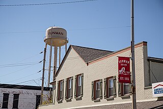
Sunman is a town in Adams Township, Ripley County, in the U.S. state of Indiana. The population was 1,049 at the 2010 census.

<span class="mw-page-title-main">Gove City, Kansas</span> City in Gove County, Kansas

Gove City, more commonly known as Gove, is a city in and the county seat of Gove County, Kansas, United States. As of the 2020 census, the population of the city was 80.

<span class="mw-page-title-main">Easton, Maine</span> Town in the state of Maine, United States

Easton is a town in Aroostook County, Maine, United States. The population was 1,320 at the 2020 census.

<span class="mw-page-title-main">Masardis, Maine</span> Town in Maine, United States

Masardis is a town in Aroostook County, Maine, United States. The population was 204 at the 2020 census.

Danforth is a town in Washington County, Maine, United States. The town was named for proprietor Thomas Danforth. The population was 587 at the 2020 census. The town contains the villages of Danforth and Eaton. East Grand High School is located in Danforth.

<span class="mw-page-title-main">Winifred, Montana</span> Town in Montana, United States

Winifred is a small town in rural north-central Fergus County, Montana, United States. It was founded in 1913 and provides services for its region's populace. The town population was 172 at the 2020 census. The current mayor is Travis Willson.

<span class="mw-page-title-main">McVille, North Dakota</span> City in North Dakota, United States

McVille is a city in Nelson County, North Dakota, United States. The population was 392 at the 2020 census. McVille was founded in 1906.

<span class="mw-page-title-main">Montpelier, North Dakota</span> City in North Dakota, United States

Montpelier is a city in Stutsman County, North Dakota, United States. The population was 85 at the 2020 census. Montpelier was founded in 1885.

<span class="mw-page-title-main">Unity, Oregon</span> City in Oregon, United States

Unity is a city in Baker County, Oregon, United States, located in the Burnt River Valley. The population was 71 at the 2010 census.

<span class="mw-page-title-main">Albion, Washington</span> Town in Washington, United States

Albion is a town in Whitman County, Washington, United States. The population was 550 at the 2020 Census.

<span class="mw-page-title-main">Quinwood, West Virginia</span> Town in West Virginia, United States

Quinwood is a town and former coal town in Greenbrier County, West Virginia, United States. The population was 220 at the 2020 census.

<span class="mw-page-title-main">Athens, West Virginia</span> Town in West Virginia, United States

Athens is a town in Mercer County, West Virginia, United States. The population was 944 at the 2020 census. It is part of the Bluefield, WV-VA micropolitan area which has a population of 107,578. Athens is the home of Concord University.

<span class="mw-page-title-main">Granville, West Virginia</span> Town in West Virginia

Granville is a town in Monongalia County, West Virginia, United States. The population was 1,355 at the 2020 census. It is included in the Morgantown metropolitan area.

<span class="mw-page-title-main">Albright, West Virginia</span> Town in West Virginia, United States

Albright is a town in central Preston County, West Virginia, United States, along the Cheat River. The population was 260 at the 2020 census. A former coal town, it is part of the Morgantown metropolitan area.

<span class="mw-page-title-main">Terra Alta, West Virginia</span> Town in West Virginia, United States

Terra Alta is a town in eastern Preston County, West Virginia, United States. The population was 1,415 at the 2020 census. It is part of the Morgantown metropolitan area.

<span class="mw-page-title-main">Bancroft, West Virginia</span> Town in West Virginia, United States

Bancroft is a town in Putnam County, West Virginia, United States, along the Kanawha River. The population was 389 at the 2020 census. It is part of the Huntington–Ashland metropolitan area.

<span class="mw-page-title-main">Huttonsville, West Virginia</span> Town in West Virginia, United States

Huttonsville is a town in Randolph County, West Virginia, United States, along the Tygart Valley River. The population was 163 at the 2020 census.

<span class="mw-page-title-main">Hambleton, West Virginia</span> Town in West Virginia, United States

Hambleton is a town in Tucker County, West Virginia, United States. The population was 216 at the 2020 census. Hambleton was established in 1889, but not incorporated until 1905. It was named by then United States Senator Stephen B. Elkins in honor of a stockholder by this name in the West Virginia Central Railroad Company. The town was previously known as Hulings.

References

  1. "2019 U.S. Gazetteer Files". United States Census Bureau. Retrieved August 7, 2020.
  2. 1 2 "U.S. Census website". United States Census Bureau . Retrieved January 31, 2008.
  3. "US Board on Geographic Names". United States Geological Survey. October 25, 2007. Retrieved January 31, 2008.
  4. "Iaeger town, West Virginia - Census Bureau Profile". data.census.gov. Retrieved May 7, 2022.
  5. Kenny, Hamill (1945). West Virginia Place Names: Their Origin and Meaning, Including the Nomenclature of the Streams and Mountains. Piedmont, WV: The Place Name Press. p. 323.
  6. "US Gazetteer files 2010". United States Census Bureau. Archived from the original on January 12, 2012. Retrieved January 24, 2013.
  7. Climate Summary for Iaeger, West Virginia
  8. "Decennial Census of Population and Housing". Census.gov. Retrieved May 7, 2022.
  9. "U.S. Census website". United States Census Bureau . Retrieved January 24, 2013.