Man, West Virginia

Last updated

Man, West Virginia
Man, West Virginia.jpg
Main Street in Man
Logan County West Virginia Incorporated and Unincorporated areas Man Highlighted.svg
Location of Man in Logan County, West Virginia.
Coordinates: 37°44′34″N81°52′31″W / 37.74278°N 81.87528°W / 37.74278; -81.87528
Country United States
State West Virginia
County Logan
Government
  MayorJohn Fekete
  Town ClerkMisty Morgan
Area
[1]
  Total1.15 sq mi (2.98 km2)
  Land1.10 sq mi (2.84 km2)
  Water0.06 sq mi (0.14 km2)
Elevation
738 ft (225 m)
Population
 (2020) [2] [3]
  Total772
  Estimate 
(2021) [2]
759
Time zone UTC-5 (Eastern (EST))
  Summer (DST) UTC-4 (EDT)
ZIP code
25635
Area code(s) 304 & 681
FIPS code 54-50932 [4]
GNIS feature ID1542706 [5]

Man is a town in Logan County, West Virginia, United States. The population was 772 at the 2020 census. [6] The town is located along the Guyandotte River at the mouth of Buffalo Creek, [7] which was the site of the 1972 Buffalo Creek Flood following a dam collapse. The name of the town reportedly derives from the last syllable of the surname of Ulysses Hinchman, who was a member of the House of Delegates from Logan County between 1866 and 1869. [8]

Contents

Geography

According to the United States Census Bureau, the town has a total area of 1.16 square miles (3.00 km2), of which 1.10 square miles (2.85 km2) is land and 0.06 square miles (0.16 km2) is water. [9]

Climate

The climate in this area is characterized by hot, humid summers and generally mild to cool winters. According to the Köppen Climate Classification system, Man has a humid subtropical climate, abbreviated "Cfa" on climate maps. [10]

Demographics

Historical population
CensusPop.Note
1930 835
1940 1,34260.7%
1950 1,63221.6%
1960 1,486−8.9%
1970 1,201−19.2%
1980 1,33311.0%
1990 914−31.4%
2000 770−15.8%
2010 759−1.4%
2020 7721.7%
2021 (est.)759 [2] −1.7%
U.S. Decennial Census [11] [12]

2010 census

At the 2010 census there were 759 people, 324 households, and 221 families living in the town. The population density was 690.0 inhabitants per square mile (266.4/km2). There were 362 housing units at an average density of 329.1 per square mile (127.1/km2). The racial makeup of the town was 96.0% White, 1.4% African American, 0.1% Native American, 1.7% Asian, and 0.7% from other races. Hispanic or Latino of any race were 0.7%. [13]

Of the 324 households 28.4% had children under the age of 18 living with them, 51.9% were married couples living together, 12.0% had a female householder with no husband present, 4.3% had a male householder with no wife present, and 31.8% were non-families. 26.9% of households were one person and 10.5% were one person aged 65 or older. The average household size was 2.34 and the average family size was 2.80.

The median age in the town was 44 years. 20.2% of residents were under the age of 18; 7% were between the ages of 18 and 24; 24.8% were from 25 to 44; 31.2% were from 45 to 64; and 16.9% were 65 or older. The gender makeup of the town was 49.4% male and 50.6% female.

2000 census

At the 2000 census there were 770 people, 336 households, and 229 families living in the town. The population density was 1,313.1 inhabitants per square mile (503.9/km2). There were 363 housing units at an average density of 619.0 per square mile (237.6/km2). The racial makeup of the town was 94.68% White, 1.95% African American, 3.25% Asian and 0.13% Pacific Islander. Hispanic or Latino of any race were 0.91%. [4]

Of the 336 households 24.1% had children under the age of 18 living with them, 51.5% were married couples living together, 12.8% had a female householder with no husband present, and 31.8% were non-families. 27.4% of households were one person and 14.6% were one person aged 65 or older. The average household size was 2.29 and the average family size was 2.79.

The age distribution was 19.4% under the age of 18, 8.1% from 18 to 24, 24.4% from 25 to 44, 29.9% from 45 to 64, and 18.3% 65 or older. The median age was 44 years. For every 100 females, there were 90.1 males. For every 100 females age 18 and over, there were 85.9 males.

The median household income was $40,179 and the median family income was $45,893. Males had a median income of $37,212 versus $24,583 for females. The per capita income for the town was $21,304. About 18.9% of families and 21.2% of the population were below the poverty line, including 36.3% of those under age 18 and 10.2% of those age 65 or over.

Notable people

Related Research Articles

<span class="mw-page-title-main">Knox, New York</span> Town in New York, United States

Knox is a town in Albany County, New York, United States. The population was 2,635 at the 2020 census.

Bovina is a town in Delaware County, New York, United States. The population was 658 at the 2020 census. The name "Bovina" was suggested by General Erastus Root, who noted the area's fitness for grazing. Bovina is an interior town in the eastern part of the county.

Hamden is a town in Delaware County, New York, United States. The population was 1,137 at the 2020 census.

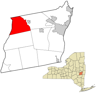
Harpersfield is a town in Delaware County, New York, United States. The population was 1,442 at the 2020 census. The town is on the northern border of the county.

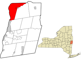
Kortright is a town in Delaware County, New York, United States. The population was 1,544 at the 2020 census. The town is in the northern part of the county.

Masonville is a town in Delaware County, New York, United States. The population was 1,239 at the 2020 census. The town is in the western part of the county.

<span class="mw-page-title-main">Halcott, New York</span> Town in New York, United States

Halcott is a town in Greene County, New York, United States. The population was 249 in 2020, down from 258 at the 2010 census. The town is in the southwestern corner of the county.

<span class="mw-page-title-main">Jewett, New York</span> Town in New York, United States

Jewett is a town centrally located in Greene County, New York, United States. The population was 879 at the 2020 census. The town is named for Freeborn G. Jewett, justice of the New York Supreme Court.

<span class="mw-page-title-main">Prattsville (town), New York</span> Town in New York, United States

Prattsville is a town in Greene County, New York, United States. The town is in the northwestern part of the county. As of the 2020 census, the population was 774.

Wilna is a town in Jefferson County, New York, United States. The population was 5,732 at the 2020 census. The town is on the eastern side of the county and is east of Watertown.

<span class="mw-page-title-main">Petersburgh, New York</span> Town in New York, United States

Petersburgh is a town located in the northeast section of Rensselaer County, New York, United States. The population was 1,372 at the 2020 census. The town was named after an early settler named Peter Simmons.

<span class="mw-page-title-main">Carlisle, New York</span> Town in New York, United States

Carlisle is a town in northern Schoharie County, New York, United States. The population was 1,768 at the 2020 census.

<span class="mw-page-title-main">Seward, New York</span> Town in New York, United States

Seward is a town in Schoharie County, New York, United States. The population was 1,583 at the 2020 census. The town is named after senator, governor, and secretary of state William H. Seward.

<span class="mw-page-title-main">Wright, New York</span> Town in New York, United States

Wright is a town in Schoharie County, New York, United States. The population was 1,516 at the 2020 census. The town was named after governor Silas Wright.

<span class="mw-page-title-main">Johnsburg, New York</span> Town in New York, United States

Johnsburg is a town in the northwestern corner of Warren County, New York, United States. It is part of the Glens Falls Metropolitan Statistical Area. The town population was 2,143 at the 2020 census. The town is named after John Thurman, an early settler and founder. Johnsburg is the largest town in Warren County by area.

<span class="mw-page-title-main">Easton, New York</span> Town in New York, United States

Easton is a town in southwestern Washington County, New York, United States along the county's western boundary. It is part of the Glens Falls Metropolitan Statistical Area. The town population was 2,279 at the 2020 census. The town adopted English as its official language on July 6, 2010.

<span class="mw-page-title-main">Matewan, West Virginia</span> Town in West Virginia, United States

Matewan is a town in Mingo County, West Virginia, United States at the confluence of the Tug Fork River and Mate Creek. The population was 412 at the 2020 census, down from 499 in 2010. The Norfolk Southern Railway's Pocahontas District passes through the town. It was a key site of the Coal Wars and the location of the Battle of Matewan in 1920.

<span class="mw-page-title-main">Hunter, New York</span> Town in New York, United States

Hunter is a town located in Greene County, New York, United States. The population was 3,035 at the time of the 2020 census. The town contains two villages, one named Hunter on the west, and the second called Tannersville, as well as a number of hamlets such as Haines Falls, Platte Clove, Lanesville and Edgewood. Additionally, there are three residential parks location within town limits: Onteora Park, Twilight Park and Elka Park. The town is on the southern border of Greene County and abuts the towns of Woodstock and Saugerties, located in Ulster County.

<span class="mw-page-title-main">Schaghticoke, New York</span> Town in New York, United States

SchaghticokeSKAT-i-kohk is a town in Rensselaer County, New York, United States. The population was 7,445 at the 2020 census. It was named for the Schaghticoke, a Native American tribe formed in the seventeenth century from an amalgamation of remnant peoples of eastern New York and New England. The tribe has one of the oldest reservations in the United States, located in what is now Litchfield County, Connecticut. It has been recognized by the state of Connecticut but has not yet achieved federal recognition.

<span class="mw-page-title-main">Plattekill, New York</span> Place in New York, United States

Plattekill is a town in Ulster County, New York, United States. The population was 10,424 in 2020, a slight decrease from 10,499 at the 2010 census. The name is derived from a stream, the Platte Kill.

References

  1. "2019 U.S. Gazetteer Files". United States Census Bureau. Retrieved August 7, 2020.
  2. 1 2 3 "City and Town Population Totals: 2020-2021". Census.gov. US Census Bureau. Retrieved July 3, 2022.
  3. US Census Bureau, 2020 Results, Matewan town, West Virginia https://www.census.gov/search-results.html?searchType=web&cssp=SERP&q=Man%20town,%20West%20Virginia
  4. 1 2 "U.S. Census website". United States Census Bureau . Retrieved January 31, 2008.
  5. "US Board on Geographic Names". United States Geological Survey. October 25, 2007. Retrieved January 31, 2008.
  6. US Census Bureau, 2020 Results, Man town, West Virginia https://www.census.gov/search-results.html?searchType=web&cssp=SERP&q=Man%20town,%20West%20Virginia
  7. West Virginia Atlas & Gazetteer. Yarmouth, Maine: DeLorme. 1997. p. 57. ISBN   0-89933-246-3.
  8. Kenny, Hamill (1945). West Virginia Place Names: Their Origin and Meaning, Including the Nomenclature of the Streams and Mountains. Piedmont, WV: The Place Name Press. p. 400.
  9. "US Gazetteer files 2010". United States Census Bureau. Archived from the original on January 25, 2012. Retrieved January 24, 2013.
  10. Climate Summary for Man, West Virginia
  11. "Census of Population and Housing". Census.gov. Retrieved June 4, 2015.
  12. "U.S. Census Bureau Search Results".
  13. "U.S. Census website". United States Census Bureau . Retrieved January 24, 2013.