West Hamlin, West Virginia

Last updated

West Hamlin, West Virginia
Motto: 
Always Free
Lincoln County West Virginia Incorporated and Unincorporated areas West Hamlin Highlighted.svg
Location of West Hamlin in Lincoln County, West Virginia.
Coordinates: 38°17′8″N82°11′31″W / 38.28556°N 82.19194°W / 38.28556; -82.19194
Country United States
State West Virginia
County Lincoln
Government
  MayorFARRIS H. BURTON, JR.
Area
[1]
  Total0.55 sq mi (1.43 km2)
  Land0.53 sq mi (1.38 km2)
  Water0.02 sq mi (0.05 km2)
Elevation
587 ft (179 m)
Population
 (2020) [2]
  Total519
  Estimate 
(2021) [2]
509
  Density1,337.08/sq mi (516.34/km2)
Time zone UTC-5 (Eastern (EST))
  Summer (DST) UTC-4 (EDT)
ZIP code
25571
Area code 304
FIPS code 54-85804 [3]
GNIS feature ID1548934 [4]
Website local.wv.gov/westhamlin

West Hamlin is a town in Lincoln County, West Virginia, United States, along the Guyandotte River. The population was 519 at the 2020 census, and is now down to 509, according to the 2021 census. [2] West Hamlin is a part of the Huntington-Ashland, WV-KY-OH, Metropolitan Statistical Area (MSA). West Hamlin is west of the county seat at Hamlin, hence the name. [5] [6]

Contents

Geography

West Hamlin is located at 38°17′8″N82°11′31″W / 38.28556°N 82.19194°W / 38.28556; -82.19194 (38.285461, -82.191991). [7]

According to the United States Census Bureau, the town has a total area of 0.55 square miles (1.42 km2), of which 0.53 square miles (1.37 km2) is land and 0.02 square miles (0.05 km2) is water. [8]

Demographics

Historical population
CensusPop.Note
1950 793
1960 788−0.6%
1970 715−9.3%
1980 643−10.1%
1990 423−34.2%
2000 69664.5%
2010 77411.2%
2020 519−32.9%
2021 (est.)509 [2] −1.9%
U.S. Decennial Census [9]

2010 census

At the 2010 census there were 774 people, 356 households, and 211 families living in the town. The population density was 1,460.4 inhabitants per square mile (563.9/km2). There were 395 housing units at an average density of 745.3 per square mile (287.8/km2). The racial makeup of the town was 98.3% White, 0.1% African American, and 1.6% from two or more races. Hispanic or Latino of any race were 0.9%. [10]

Of the 356 households 30.9% had children under the age of 18 living with them, 41.3% were married couples living together, 14.6% had a female householder with no husband present, 3.4% had a male householder with no wife present, and 40.7% were non-families. 39.0% of households were one person and 18.5% were one person aged 65 or older. The average household size was 2.17 and the average family size was 2.83.

The median age in the town was 42.6 years. 23% of residents were under the age of 18; 7.9% were between the ages of 18 and 24; 22.8% were from 25 to 44; 27.8% were from 45 to 64; and 18.5% were 65 or older. The gender makeup of the town was 43.8% male and 56.2% female.

2000 census

At the 2000 census there were 696 people, 305 households, and 190 families living in the town. The population density was 1,278.9 inhabitants per square mile (497.6/km2). There were 335 housing units at an average density of 615.6 per square mile (239.5/km2). The racial makeup of the town was 99.14% White, and 0.86% from two or more races. Hispanic or Latino of any race were 0.72%. [3]

Of the 305 households 29.2% had children under the age of 18 living with them, 43.3% were married couples living together, 16.7% had a female householder with no husband present, and 37.4% were non-families. 35.1% of households were one person and 19.7% were one person aged 65 or older. The average household size was 2.26 and the average family size was 2.88.

The age distribution was 25.1% under the age of 18, 6.8% from 18 to 24, 25.1% from 25 to 44, 24.7% from 45 to 64, and 18.2% 65 or older. The median age was 40 years. For every 100 females, there were 87.1 males. For every 100 females age 18 and over, there were 82.2 males.

The median household income was $19,250 and the median family income was $27,308. Males had a median income of $32,857 versus $21,250 for females. The per capita income for the town was $13,072. About 28.9% of families and 35.4% of the population were below the poverty line, including 50.0% of those under age 18 and 31.5% of those age 65 or over.

Related Research Articles

<span class="mw-page-title-main">Rogersville, Alabama</span> Town in Alabama, United States

Rogersville is a town in Lauderdale County, Alabama, United States. As of the 2018 census, the population of the town is 1,231, up from 1,199 in 2000.

<span class="mw-page-title-main">Arriba, Colorado</span> Town in Lincoln County, Colorado, United States

Arriba is a Statutory Town located in Lincoln County, Colorado, United States. The town population was 202 at the 2020 United States census. Arriba is the Spanish word for "on high" or "above others."

<span class="mw-page-title-main">Hamlin, Kansas</span> City in Brown County, Kansas

Hamlin is a city in Brown County, Kansas, United States. As of the 2020 census, the population of the city was 25.

<span class="mw-page-title-main">Caswell, Maine</span> Town in the state of Maine, United States

Caswell is a town in Aroostook County, Maine, United States. The population was 293 at the 2020 census.

<span class="mw-page-title-main">Hamlin, Maine</span> Town in the state of Maine, United States

Hamlin is a town in Aroostook County, Maine, United States. It is located on the Canada–US border with a border crossing into Grand Falls, New Brunswick and is the closest continental location to Europe in the United States. Hamlin's northeastern corner is the closest point in the mainland United States to Western Europe, situated at a distance of 2,508 miles (4,018 km) from the closest point in Europe to the USA, Achill Head. The population was 166 at the 2020 census.

<span class="mw-page-title-main">Mount Ivy, New York</span> Census-designated place in New York, United States

Mount Ivy is a hamlet and census-designated place in the Town of Haverstraw, in Rockland County, New York, United States. It is located north of New City, east of Pomona, south of Thiells, and west of Garnerville. The population was 6,878 at the 2010 census.

<span class="mw-page-title-main">Princeton, South Carolina</span> Census-designated place in South Carolina, United States

Princeton is an unincorporated community and census-designated place (CDP) in Laurens County, South Carolina, United States of America. The population was 62 at the 2010 census. It is part of the Greenville–Mauldin–Easley Metropolitan Statistical Area.

<span class="mw-page-title-main">Estelline, South Dakota</span> City in South Dakota, United States

Estelline is a city in Hamlin County, South Dakota, United States. It is part of the Watertown, South Dakota Micropolitan Statistical Area. The population was 749 at the 2020 census.

<span class="mw-page-title-main">Hayti, South Dakota</span> Town in South Dakota, United States

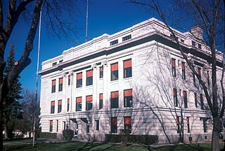
Hayti is a town in and county seat of Hamlin County, South Dakota, United States. The population was 393 at the 2020 census. It is part of the Watertown, South Dakota Micropolitan Statistical Area. It is the county seat of Hamlin County.

<span class="mw-page-title-main">Sylvester, West Virginia</span> Town in West Virginia, United States

Sylvester is a town in Boone County, West Virginia, United States, along the Big Coal River. The population was 166 at the 2020 census. Sylvester was incorporated on April 11, 1952, by the Boone County Circuit Court. Sylvester bears the name of a family of settlers.

<span class="mw-page-title-main">Hamlin, West Virginia</span> Town in West Virginia, United States

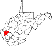
Hamlin is a town in and the county seat of Lincoln County, West Virginia, United States, along the Mud River. The population was recorded as 1,040 at the 2020 census. It is part of the Huntington–Ashland metropolitan area.

<span class="mw-page-title-main">West Logan, West Virginia</span> Town in West Virginia, United States

West Logan is a town along the Guyandotte River in Logan County, West Virginia, United States. The population was 400 at the 2020 census. For unknown reasons, some sources report West Logan to lay west of the county seat at Logan, attributing to this fact the name.

<span class="mw-page-title-main">Leon, West Virginia</span> Town in West Virginia, United States

Leon is a town in Mason County, West Virginia, United States, situated along the Kanawha River. The population was 137 at the 2020 census. It is part of the Point Pleasant, WV–OH Micropolitan Statistical Area.

<span class="mw-page-title-main">Mason, West Virginia</span> Town in West Virginia, United States

Mason, also known as Mason City, is a town in Mason County, West Virginia, United States. The population was 865 at the 2020 census. It is part of the Point Pleasant, WV–OH Micropolitan Statistical Area.

<span class="mw-page-title-main">Mabscott, West Virginia</span> Town in West Virginia, United States

Mabscott is a town in Raleigh County, West Virginia, United States. The population was 1,333 at the 2020 census. The town's name is a contraction of the name Mabel Scott, wife of local coal operator Cyrus H. Scott.

<span class="mw-page-title-main">Sophia, West Virginia</span> Town in West Virginia, United States

Sophia is a town in Raleigh County, West Virginia, United States. It was incorporated in 1912. The population was 1,124 at the 2020 census.

<span class="mw-page-title-main">Fort Gay, West Virginia</span> Town in West Virginia, United States

Fort Gay is a town in Wayne County, West Virginia, United States, situated along the Tug Fork and Big Sandy rivers. The town adjoins Louisa, Kentucky. The population was 677 at the 2020 census.

<span class="mw-page-title-main">North Hills, West Virginia</span> Town in West Virginia, United States

North Hills is a town in Wood County, West Virginia, United States. It is a suburb of Parkersburg. The population was 837 at the 2020 census. North Hills was incorporated on February 15, 1979.

<span class="mw-page-title-main">Bohners Lake, Wisconsin</span> CDP in Wisconsin, United States

Bohners Lake is a census-designated place (CDP) in Racine County, Wisconsin, United States. Its first syllable is pronounced as in "bone". The population of the CDP was 2,374 at the 2020 census. It is politically part of the Town of Burlington, together with Browns Lake, Wisconsin. There has been discussion of incorporating Bohners Lake as a village to prevent annexation by the City of Burlington. It was named for Antony Bohner, a French immigrant who established a resort on the lake of the same name.

<span class="mw-page-title-main">Randolph, Maine</span> Town in the state of Maine, United States

Randolph is a town and a census-designated place (CDP) in Kennebec County, Maine, United States. The population was 1,743 at the 2020 census. The town was named for Randolph, Massachusetts. Randolph is included in the Augusta, Maine micropolitan New England City and Town Area.

References

  1. "2019 U.S. Gazetteer Files". United States Census Bureau. Retrieved August 7, 2020.
  2. 1 2 3 4 "City and Town Population Totals: 2020-2021". Census.gov. US Census Bureau. Retrieved July 3, 2022.
  3. 1 2 "U.S. Census website". United States Census Bureau . Retrieved January 31, 2008.
  4. "US Board on Geographic Names". United States Geological Survey. October 25, 2007. Retrieved January 31, 2008.
  5. Capace, Nancy (1999). Encyclopedia of West Virginia. North American Book Dist LLC. p. 196. ISBN   978-0-403-09843-9.
  6. Kenny, Hamill (1945). West Virginia Place Names: Their Origin and Meaning, Including the Nomenclature of the Streams and Mountains. Piedmont, WV: The Place Name Press. p. 667.
  7. "US Gazetteer files: 2010, 2000, and 1990". United States Census Bureau. February 12, 2011. Retrieved April 23, 2011.
  8. "US Gazetteer files 2010". United States Census Bureau . Retrieved January 24, 2013.
  9. "Census of Population and Housing". Census.gov. Retrieved June 4, 2015.
  10. "U.S. Census website". United States Census Bureau . Retrieved January 24, 2013.