Hendricks, West Virginia

Last updated

Hendricks, West Virginia
Tucker County West Virginia Incorporated and Unincorporated areas Hendricks Highlighted.svg
Location of Hendricks in Tucker County, West Virginia.
Coordinates: 39°4′30″N79°37′53″W / 39.07500°N 79.63139°W / 39.07500; -79.63139
Country United States
State West Virginia
County Tucker
Area
[1]
  Total0.35 sq mi (0.90 km2)
  Land0.34 sq mi (0.89 km2)
  Water0.00 sq mi (0.01 km2)
Elevation
1,716 ft (523 m)
Population
 (2020) [2]
  Total226
  Estimate 
(2021) [2]
221
  Density751.46/sq mi (290.32/km2)
Time zone UTC-5 (Eastern (EST))
  Summer (DST) UTC-4 (EDT)
ZIP code
26271
Area code 304
FIPS code 54-36460 [3]
GNIS feature ID1554682 [4]
Website https://local.wv.gov/hendricks/Pages/default.aspx

Hendricks is a town in Tucker County, West Virginia, United States. The population was 226 at the 2020 census. [2] The Blackwater River and the Dry Fork join at Hendricks to form the Black Fork, a principal tributary of the Cheat River. [5]

Contents

History

In 1803, after three unproductive years in nearby Canaan Valley, German settler Henry Fansler (d. 1843) settled at the mouth of the Blackwater River at the present site of Hendricks. He called the settlement "Eden". [6] Hendricks was incorporated in 1894 and was named by local coal and timber magnate Henry Gassaway Davis for Vice President Thomas A. Hendricks. [7]

Geography

Hendricks is located at 39°4′30″N79°37′53″W / 39.07500°N 79.63139°W / 39.07500; -79.63139 (39.074883, -79.631399). [8]

According to the United States Census Bureau, the town has a total area of 0.34 square miles (0.88 km2), all land. [9]

Demographics

The Black Fork in Hendricks Black Fork Hendricks West Virginia.jpg
The Black Fork in Hendricks
Historical population
CensusPop.Note
1900 317
1910 640101.9%
1920 622−2.8%
1930 484−22.2%
1940 53911.4%
1950 492−8.7%
1960 407−17.3%
1970 317−22.1%
1980 39023.0%
1990 303−22.3%
2000 3195.3%
2010 272−14.7%
2020 226−16.9%
2021 (est.)221 [2] −2.2%
U.S. Decennial Census [10]

2010 census

At the 2010 census there were 272 people, 112 households, and 89 families living in the town. The population density was 800.0 inhabitants per square mile (308.9/km2). There were 145 housing units at an average density of 426.5 per square mile (164.7/km2). The racial makeup of the town was 100.0% White. [11] Of the 112 households 29.5% had children under the age of 18 living with them, 68.8% were married couples living together, 4.5% had a female householder with no husband present, 6.3% had a male householder with no wife present, and 20.5% were non-families. 17.9% of households were one person and 11.7% were one person aged 65 or older. The average household size was 2.43 and the average family size was 2.72.

The median age in the town was 44.5 years. 18.4% of residents were under the age of 18; 7.7% were between the ages of 18 and 24; 24.6% were from 25 to 44; 30.9% were from 45 to 64; and 18.4% were 65 or older. The gender makeup of the town was 48.9% male and 51.1% female.

2000 census

At the 2000 census there were 319 people, 123 households, and 100 families living in the town. The population density was 925.9 inhabitants per square mile (362.3/km2). There were 138 housing units at an average density of 400.5 per square mile (156.7/km2). The racial makeup of the town was 99.06% White, 0.31% Native American, 0.31% from other races, and 0.31% from two or more races. Hispanic or Latino of any race were 0.31%. [3]

Of the 123 households 34.1% had children under the age of 18 living with them, 71.5% were married couples living together, 7.3% had a female householder with no husband present, and 17.9% were non-families. 17.9% of households were one person and 11.4% were one person aged 65 or older. The average household size was 2.59 and the average family size was 2.85.

The age distribution was 23.8% under the age of 18, 9.7% from 18 to 24, 20.7% from 25 to 44, 29.5% from 45 to 64, and 16.3% 65 or older. The median age was 42 years. For every 100 females, there were 100.6 males. For every 100 females age 18 and over, there were 102.5 males.

The median household income was $26,705 and the median family income was $27,500. Males had a median income of $26,042 versus $17,500 for females. The per capita income for the town was $21,315. About 25.5% of families and 23.3% of the population were below the poverty line, including 33.3% of those under age 18 and 21.3% of those age 65 or over.

Related Research Articles

<span class="mw-page-title-main">Millry, Alabama</span> Town in Alabama, United States

Millry is a town in Washington County, Alabama, United States. According to the 1950 U.S. Census records, it incorporated in 1947. The population was 546 at the 2010 census, down from 615 in 2000.

<span class="mw-page-title-main">Lizton, Indiana</span> Town in Indiana, United States

Lizton is a town in Union Township, Hendricks County, Indiana, United States. The population was 488 at the 2010 Census. It is one of the three towns that make up North West Hendricks School Corporation.

<span class="mw-page-title-main">North Salem, Indiana</span> Town in Indiana, United States

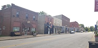
North Salem is a town in Eel River Township, Hendricks County, Indiana, United States. The population was 518 at the 2010 Census.

<span class="mw-page-title-main">Dodd City, Texas</span> Town in Texas, United States

Dodd City is a town in Fannin County, in the U.S. state of Texas. The population was 369 at the 2010 census, down from 419 at the 2000 census.

<span class="mw-page-title-main">Whitesville, West Virginia</span> Town in West Virginia, United States

Whitesville is a town and former coal town in Boone County, West Virginia, United States, along the Big Coal River. The population was 361 at the 2020 census. Whitesville was incorporated on August 15, 1935, by the Boone County Circuit Court. The town derives its name from B. W. White, a pioneer settler. Whitesville was formerly known as Jarrold's Valley and Pritchard City.

<span class="mw-page-title-main">Sand Fork, West Virginia</span> Town in West Virginia, United States

Sand Fork is a town in Gilmer County, West Virginia, United States. The population was 182 at the 2020 census. It is located along the Little Kanawha River, at the mouth of the Sand Fork.

<span class="mw-page-title-main">Jane Lew, West Virginia</span> Town in West Virginia, United States

Jane Lew is a town in Lewis County, West Virginia, United States. The population was 409 at the time of the 2020 census.

<span class="mw-page-title-main">Mitchell Heights, West Virginia</span> Town in West Virginia, United States

Mitchell Heights is a town in Logan County, West Virginia, United States. The population was 315 at the 2020 census. The town was named for an early farm on which it was established.

<span class="mw-page-title-main">Glen Dale, West Virginia</span> Town in West Virginia

Glen Dale is a city in Marshall County, West Virginia, United States, along the Ohio River. It is part of the Wheeling, West Virginia Metropolitan Statistical Area. The population was 1,514 at the 2020 census. Glen Dale was incorporated in 1924. It is in the northwest part of the county, which is above the Mason–Dixon line and forms the base of the Northern Panhandle of West Virginia.

<span class="mw-page-title-main">Henderson, West Virginia</span> Unincorporated Town in West Virginia, United States

Henderson is an unincorporated community and former town in Mason County, West Virginia, United States, at the confluence of the Ohio and Kanawha Rivers. The population was 231 at the 2020 census. It is part of the Point Pleasant, WV–OH Micropolitan Statistical Area. The town was incorporated in 1893 and named for Samuel Bruce Henderson, who owned the townsite at the time. The town was unincorporated following a public hearing on August 11, 2022.

<span class="mw-page-title-main">Matoaka, West Virginia</span> Census-designated place in West Virginia, United States

Matoaka is a census-designated place in Mercer County, West Virginia, United States. The population was 173 at the 2020 census. It is part of the Bluefield, WV-VA micropolitan area which has a population of 100,093. This town is named for Chief Powhatan's daughter Matoaka who was better known by her nickname "Pocahontas". Matoaka became an unincorporated town when it voted to dissolve its charter in May 2018.

<span class="mw-page-title-main">Carpendale, West Virginia</span> Town in West Virginia, United States

Carpendale is a town in Mineral County, West Virginia, United States, and part of the Cumberland, MD-WV Metropolitan Statistical Area'. The population was 861 at the 2020 census. Carpendale was incorporated on January 2, 1990, by the Circuit Court. The town is a combination of three subdivisions of which its name reflects: Carpenters Addition, Millerdale I, and Millerdale II. There are no stores in Carpendale and there is only one road in and out of the town.

<span class="mw-page-title-main">Elk Garden, West Virginia</span> Town in West Virginia, United States

Elk Garden is a town in Mineral County, West Virginia, United States. It is part of the 'Cumberland, MD-WV Metropolitan Statistical Area'. The population was 211 at the 2020 census. Elk Garden High School was consolidated into Keyser High School in 1997. However the Primary School is still in session, offering classes from Pre-Kindergarten through the fifth grade. The school mascot is the Elk Garden Stags. Elk Garden was incorporated in 1890 by the Mineral County Circuit Court. It is named for an elk lick near the original town site.

<span class="mw-page-title-main">Gilbert, West Virginia</span> Town in West Virginia, United States

Gilbert is a town in Mingo County, West Virginia, United States, along the Guyandotte River. The population was 333 at the 2020 census. Gilbert was incorporated in 1918 and named for Gilbert Creek, which derives its name from the name of an early traveler in the area who was killed by Native Americans. Gilbert is known nationwide for the Hatfield-McCoy ATV Trails that are located in the area. There are a number of lodges and restaurants in Gilbert.

<span class="mw-page-title-main">Belmont, West Virginia</span> Town in West Virginia, United States

Belmont is a town in Pleasants County, West Virginia, United States. It is part of the Parkersburg–Vienna metropolitan area. The population was 872 at the 2020 census. Belmont was incorporated on April 19, 1946, by the Circuit Court of Pleasants County. The city was named for the beautiful hills in the area.

<span class="mw-page-title-main">Tunnelton, West Virginia</span> Town in West Virginia, United States

Tunnelton is a town in southwestern Preston County, West Virginia, United States. The population was 307 at the 2020 census. It is part of the Morgantown metropolitan area.

<span class="mw-page-title-main">Auburn, West Virginia</span> Town in West Virginia, United States

Auburn is a town in Ritchie County, West Virginia, United States. The population was 80 at the 2020 census.

<span class="mw-page-title-main">Pennsboro, West Virginia</span> City in West Virginia, United States

Pennsboro is a city in Ritchie County, West Virginia, United States. The population was 1,050 at the 2020 census. The city is located at the junction of U.S. Route 50 and West Virginia Route 74; the North Bend Rail Trail also passes through the city.

<span class="mw-page-title-main">Flemington, West Virginia</span> Town in West Virginia, United States

Flemington is a town in Taylor County, West Virginia, United States. The population was 311 at the 2020 census. Flemington was incorporated in 1922 by the West Virginia Circuit Court, and named for James Fleming, an early settler in the area originally from Hampshire County.

<span class="mw-page-title-main">Middlebourne, West Virginia</span> Town in West Virginia, United States

Middlebourne is a town and the county seat of Tyler County, West Virginia, United States. The population was 715 at the 2020 census.

References

  1. "2019 U.S. Gazetteer Files". United States Census Bureau. Retrieved August 7, 2020.
  2. 1 2 3 4 Bureau, US Census. "City and Town Population Totals: 2020-2021". Census.gov. US Census Bureau. Retrieved July 3, 2022.
  3. 1 2 "U.S. Census website". United States Census Bureau . Retrieved January 31, 2008.
  4. "US Board on Geographic Names". United States Geological Survey. October 25, 2007. Retrieved January 31, 2008.
  5. DeLorme (1997). West Virginia Atlas & Gazetteer. Yarmouth, Maine: DeLorme. ISBN   0-89933-246-3.
  6. Fansler, Homer Floyd (1962), History of Tucker County, West Virginia, Parsons, West Virginia: McClain Printing Company, pg 594.
  7. West Virginia Blue Book. Published annually by the Clerk's Office of the West Virginia Senate.
  8. "US Gazetteer files: 2010, 2000, and 1990". United States Census Bureau. February 12, 2011. Retrieved April 23, 2011.
  9. "US Gazetteer files 2010". United States Census Bureau. Archived from the original on January 25, 2012. Retrieved January 24, 2013.
  10. "Census of Population and Housing". Census.gov. Retrieved June 4, 2015.
  11. "U.S. Census website". United States Census Bureau . Retrieved January 24, 2013.