Whitesville, West Virginia

Last updated

Whitesville, West Virginia
Whitesville-WV3-wv.jpg
Whitesville
Logo of Whitesville, West Virginia.svg
Boone County West Virginia Incorporated and Unincorporated areas Whitesville Highlighted.svg
Location of Whitesville in Boone County, West Virginia.
Coordinates: 37°58′53″N81°32′3″W / 37.98139°N 81.53417°W / 37.98139; -81.53417
Country United States
State West Virginia
County Boone
Area
[1]
  Total0.33 sq mi (0.86 km2)
  Land0.31 sq mi (0.80 km2)
  Water0.02 sq mi (0.06 km2)
Elevation
837 ft (255 m)
Population
 (2020) [2]
  Total361
  Estimate 
(2021) [2]
351
  Density1,390.88/sq mi (536.74/km2)
Time zone UTC-5 (Eastern (EST))
  Summer (DST) UTC-4 (EDT)
ZIP code
25209
Area code 304
FIPS code 54-86836 [3]
GNIS feature ID1555976 [4]

Whitesville is a town and former coal town in Boone County, West Virginia, United States, along the Big Coal River. The population was 361 at the 2020 census. [2] Whitesville was incorporated on August 15, 1935, by the Boone County Circuit Court. The town derives its name from B. W. White, a pioneer settler. [5] Whitesville was formerly known as Jarrold's Valley and Pritchard City.

Contents

Geography

Whitesville is located at 37°58′53″N81°32′03″W / 37.981297°N 81.534055°W / 37.981297; -81.534055 (37.981297, -81.534055). [6] The town occupies a narrow section of land along both sides of the Big Coal River that stretches from the river's confluence with Toms Branch on the south to just north of the river's confluence with Seng Creek. West Virginia Route 3 (Coal River Road) traverses Whitesville, connecting the town with Sylvester to the northwest and the Beckley area to the southeast.

According to the United States Census Bureau, the town has a total area of 0.33 square miles (0.85 km2), of which 0.31 square miles (0.80 km2) is land and 0.02 square miles (0.05 km2) is water. [7]

Demographics

Historical population
CensusPop.Note
1940 942
1950 1,0178.0%
1960 774−23.9%
1970 7810.9%
1980 689−11.8%
1990 486−29.5%
2000 5207.0%
2010 514−1.2%
2020 361−29.8%
2021 (est.)351 [2] −2.8%
U.S. Decennial Census [8]

2010 census

As of the census [9] of 2010, there were 514 people, 247 households, and 125 families living in the town. The population density was 1,658.1 inhabitants per square mile (640.2/km2). There were 304 housing units at an average density of 980.6 per square mile (378.6/km2). The racial makeup of the town was 98.1% White, 0.2% African American, and 1.8% from two or more races.

There were 247 households, of which 23.1% had children under the age of 18 living with them, 36.4% were married couples living together, 12.1% had a female householder with no husband present, 2.0% had a male householder with no wife present, and 49.4% were non-families. 44.5% of all households were made up of individuals, and 20.6% had someone living alone who was 65 years of age or older. The average household size was 2.08 and the average family size was 2.92.

The median age in the town was 42.5 years. 20.4% of residents were under the age of 18; 8.5% were between the ages of 18 and 24; 24.7% were from 25 to 44; 28% were from 45 to 64; and 18.5% were 65 years of age or older. The gender makeup of the town was 47.7% male and 52.3% female.

2000 census

As of the census [3] of 2000, there were 520 people, 255 households, and 139 families living in the town. The population density was 1,244.7 inhabitants per square mile (478.0/km2). There were 346 housing units at an average density of 828.2 per square mile (318.1/km2). The racial makeup of the town was 99.23% White, 0.19% African American, 0.19% Native American, 0.19% Asian, and 0.19% from two or more races. Hispanic or Latino of any race were 0.38% of the population.

There were 255 households, out of which 18.0% had children under the age of 18 living with them, 38.0% were married couples living together, 12.5% had a female householder with no husband present, and 45.1% were non-families. 42.4% of all households were made up of individuals, and 21.2% had someone living alone who was 65 years of age or older. The average household size was 2.04 and the average family size was 2.75.

In the town, the population was spread out, with 17.3% under the age of 18, 11.3% from 18 to 24, 21.3% from 25 to 44, 27.7% from 45 to 64, and 22.3% who were 65 years of age or older. The median age was 45 years. For every 100 females, there were 84.4 males. For every 100 females age 18 and over, there were 82.2 males.

The median income for a household in the town was $19,250, and the median income for a family was $31,500. Males had a median income of $26,250 versus $15,417 for females. The per capita income for the town was $13,217. About 23.1% of families and 29.9% of the population were below the poverty line, including 40.2% of those under age 18 and 15.0% of those age 65 or over.

Upper Big Branch Miners Memorial

Whitesville is home to the Upper Big Branch Miners Memorial, a monument dedicated to the miners who were killed in the Upper Big Branch Mine disaster in nearby Montcoal in April 2010.

Related Research Articles

<span class="mw-page-title-main">Carbon, Indiana</span> Town in Indiana, United States

Carbon is a town in Van Buren Township, Clay County, Indiana, United States. The population was 397 at the 2010 census. It is part of the Terre Haute Metropolitan Statistical Area.

<span class="mw-page-title-main">Whitesville, Kentucky</span> City in Kentucky, United States

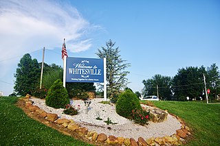
Whitesville is a home rule-class city in Daviess County, Kentucky, United States. The population was 580 as of the 2020 Census, up from 552 as of the 2010 census,. It is included in the Owensboro, Kentucky Metropolitan Statistical Area. The city was founded in 1844 by Dr. William White, and named for him. The current mayor of Whitesville is Patsy Mayfield.

Independence is a town in Allegany County, New York, United States. The population was 1,095 at the 2020 census. The town is in the southeast corner of Allegany County, southeast of the village of Wellsville.

<span class="mw-page-title-main">New Straitsville, Ohio</span> Village in Ohio, United States

New Straitsville is a village in Perry County, Ohio, United States. The population was 652 at the 2020 census.

<span class="mw-page-title-main">Junior, West Virginia</span> Town in West Virginia, United States

Junior is a town in Barbour County, West Virginia, United States, situated along the Tygart Valley River. The population was 384 at the 2020 census.

<span class="mw-page-title-main">Sylvester, West Virginia</span> Town in West Virginia, United States

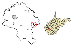
Sylvester is a town in Boone County, West Virginia, United States, along the Big Coal River. The population was 166 at the 2020 census. Sylvester was incorporated on April 11, 1952, by the Boone County Circuit Court. Sylvester bears the name of a family of settlers.

<span class="mw-page-title-main">Bayard, West Virginia</span> Town in West Virginia, United States

Bayard is a town in Grant County, West Virginia, United States. The population was 200 at the 2020 census. Bayard was incorporated in 1893 and named in honor of Thomas F. Bayard, Jr., who later became a United States senator from Delaware (1923–1929). Bayard was founded on the West Virginia Central and Pittsburgh Railroad as a coal mining community. Coal mining has remained the town's chief industry.

<span class="mw-page-title-main">Pratt, West Virginia</span> Town in West Virginia, United States

Pratt is a town in Kanawha County, West Virginia, United States, along the Kanawha River. The population was 482 at the 2020 census.

<span class="mw-page-title-main">Barrackville, West Virginia</span> Town in West Virginia, United States

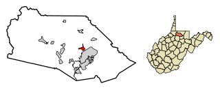
Barrackville is a town in Marion County, West Virginia, United States. The population was 1,211 at the 2020 census.

<span class="mw-page-title-main">Grant Town, West Virginia</span> Town in West Virginia, United States

Grant Town is a town in Marion County, West Virginia, in the eastern United States. The population was 690 at the 2020 census.

<span class="mw-page-title-main">Anawalt, West Virginia</span> Town in West Virginia, United States

Anawalt is a town in McDowell County, West Virginia, United States. At one time it was known as Jeanette. It is named in honor of James White Anawalt, who was then manager of Union Supply Company, a subsidiary of the United States Steel Company. The population was 186 at the 2020 census. Coal mining was the town's chief industry.

<span class="mw-page-title-main">Davy, West Virginia</span> Town in West Virginia, United States

Davy is a town in McDowell County, West Virginia, United States. The population was 420 at the 2010 census. Founded in 1873, the town was originally called Hallsville but the name would change to Davy by 1901. Davy was officially incorporated in 1948. It is a mostly residential community in a coal mining district along the main line of the Norfolk Southern Railway.

<span class="mw-page-title-main">Bramwell, West Virginia</span> Town in West Virginia, United States

Bramwell is a town in Mercer County, West Virginia, United States, along the Bluestone River. The population was 277 at the 2020 census. It is part of the Bluefield, WV-VA micropolitan area which has a population of 107,578.

<span class="mw-page-title-main">Delbarton, West Virginia</span> Town in West Virginia, United States

Delbarton is a town in Mingo County, West Virginia, United States. The population was 522 at the 2020 census.

<span class="mw-page-title-main">Gilbert, West Virginia</span> Town in West Virginia, United States

Gilbert is a town in Mingo County, West Virginia, United States, along the Guyandotte River. The population was 333 at the 2020 census. Gilbert was incorporated in 1918 and named for Gilbert Creek, which derives its name from the name of an early traveler in the area who was killed by Native Americans. Gilbert is known nationwide for the Hatfield-McCoy ATV Trails that are located in the area. There are a number of lodges and restaurants in Gilbert.

<span class="mw-page-title-main">Albright, West Virginia</span> Town in West Virginia, United States

Albright is a town in central Preston County, West Virginia, United States, along the Cheat River. The population was 260 at the 2020 census. A former coal town, it is part of the Morgantown metropolitan area.

<span class="mw-page-title-main">Bancroft, West Virginia</span> Town in West Virginia, United States

Bancroft is a town in Putnam County, West Virginia, United States, along the Kanawha River. The population was 389 at the 2020 census. It is part of the Huntington–Ashland metropolitan area.

<span class="mw-page-title-main">Lester, West Virginia</span> Town in West Virginia, United States

Lester is a town in Raleigh County, West Virginia, United States. The population was 337 at the 2020 census. The community was named after Champ Lester, a local pioneer.

<span class="mw-page-title-main">Mabscott, West Virginia</span> Town in West Virginia, United States

Mabscott is a town in Raleigh County, West Virginia, United States. The population was 1,333 at the 2020 census. The town's name is a contraction of the name Mabel Scott, wife of local coal operator Cyrus H. Scott.

<span class="mw-page-title-main">Hendricks, West Virginia</span> Town in West Virginia, United States

Hendricks is a town in Tucker County, West Virginia, United States. The population was 226 at the 2020 census. The Blackwater River and the Dry Fork join at Hendricks to form the Black Fork, a principal tributary of the Cheat River.

References

  1. "2019 U.S. Gazetteer Files". United States Census Bureau. Retrieved August 7, 2020.
  2. 1 2 3 4 "City and Town Population Totals: 2020-2021". Census.gov. US Census Bureau. Retrieved July 3, 2022.
  3. 1 2 "U.S. Census website". United States Census Bureau . Retrieved January 31, 2008.
  4. "US Board on Geographic Names". United States Geological Survey. October 25, 2007. Retrieved January 31, 2008.
  5. Kenny, Hamill (1945). West Virginia Place Names: Their Origin and Meaning, Including the Nomenclature of the Streams and Mountains. Piedmont, WV: The Place Name Press. p. 678.
  6. "US Gazetteer files: 2010, 2000, and 1990". United States Census Bureau. February 12, 2011. Retrieved April 23, 2011.
  7. "US Gazetteer files 2010". United States Census Bureau . Retrieved January 24, 2013.
  8. "Census of Population and Housing". Census.gov. Retrieved June 4, 2015.
  9. "U.S. Census website". United States Census Bureau . Retrieved January 24, 2013.