Stonewood, West Virginia

Last updated

Stonewood, West Virginia
Seal of Stonewood, West Virginia.png
Harrison County West Virginia Incorporated and Unincorporated areas Stonewood Highlighted.svg
Location of Stonewood in Harrison County, West Virginia.
Coordinates: 39°15′7″N80°18′36″W / 39.25194°N 80.31000°W / 39.25194; -80.31000
CountryUnited States
State West Virginia
County Harrison
Area
[1]
  Total0.85 sq mi (2.20 km2)
  Land0.85 sq mi (2.20 km2)
  Water0.00 sq mi (0.00 km2)
Elevation
1,037 ft (316 m)
Population
 (2020) [2]
  Total1,810
  Estimate 
(2021) [2]
1,789
  Density2,014.10/sq mi (778.02/km2)
Time zone UTC-5 (Eastern (EST))
  Summer (DST) UTC-4 (EDT)
ZIP code
26301
Area code 304
FIPS code 54-77188 [3]
GNIS feature ID1555719 [4]
Website Official website

Stonewood is a city in Harrison County, West Virginia, United States. The population was 1,810 at the 2020 census. [2]

Contents

Officially, the name Stonewood has no special meaning, and was invented for the place. Locally, the name is said to be a portmanteau of Stonewall and Norwood; two former unincorporated villages that used to neighbor each other where Stonewood exists today. [5]

Geography

Stonewood is located at 39°15′7″N80°18′36″W / 39.25194°N 80.31000°W / 39.25194; -80.31000 (39.252001, -80.309979), [6] along Elk Creek. [7]

According to the United States Census Bureau, the city has a total area of 0.85 square miles (2.20 km2), all land. [8]

Demographics

Historical population
CensusPop.Note
1950 2,066
1960 2,2026.6%
1970 1,950−11.4%
1980 2,0585.5%
1990 1,996−3.0%
2000 1,815−9.1%
2010 1,806−0.5%
2020 1,8100.2%
2021 (est.)1,789 [2] −1.2%
U.S. Decennial Census [9]

2010 census

As of the census [10] of 2010, there were 1,806 people, 819 households, and 494 families living in the city. The population density was 2,124.7 inhabitants per square mile (820.4/km2). There were 890 housing units at an average density of 1,047.1 per square mile (404.3/km2). The racial makeup of the city was 95.8% White, 1.8% African American, 0.2% Native American, 0.3% Asian, 0.1% Pacific Islander, 0.1% from other races, and 1.6% from two or more races. Hispanic or Latino of any race were 1.9% of the population.

There were 819 households, of which 23.2% had children under the age of 18 living with them, 42.5% were married couples living together, 12.7% had a female householder with no husband present, 5.1% had a male householder with no wife present, and 39.7% were non-families. 33.8% of all households were made up of individuals, and 14.3% had someone living alone who was 65 years of age or older. The average household size was 2.19 and the average family size was 2.76.

The median age in the city was 45.6 years. 18.2% of residents were under the age of 18; 5.9% were between the ages of 18 and 24; 24.8% were from 25 to 44; 30.8% were from 45 to 64; and 20.3% were 65 years of age or older. The gender makeup of the city was 47.0% male and 53.0% female.

2000 census

As of the census [3] of 2000, there were 1,815 people, 789 households, and 522 families living in the city. The population density was 2,130.8 people per square mile (824.4/km2). There were 855 housing units at an average density of 1,003.8 per square mile (388.4/km2). The racial makeup of the city was 97.80% White, 1.60% African American, 0.11% Native American, 0.06% Asian, and 0.44% from two or more races. Hispanic or Latino of any race were 0.83% of the population.

There were 789 households, out of which 24.1% had children under the age of 18 living with them, 49.3% were married couples living together, 12.9% had a female householder with no husband present, and 33.8% were non-families. 30.0% of all households were made up of individuals, and 14.8% had someone living alone who was 65 years of age or older. The average household size was 2.28 and the average family size was 2.82.

In the city, the age distribution of the population shows 19.1% under the age of 18, 7.2% from 18 to 24, 27.7% from 25 to 44, 25.8% from 45 to 64, and 20.3% who were 65 years of age or older. The median age was 42 years. For every 100 females, there were 90.5 males. For every 100 females age 18 and over, there were 85.0 males.

The median income for a household in the city was $28,000, and the median income for a family was $31,078. Males had a median income of $25,962 versus $25,788 for females. The per capita income for the city was $16,520. About 11.8% of families and 13.3% of the population were below the poverty line, including 22.6% of those under age 18 and 7.3% of those age 65 or over.

Related Research Articles

<span class="mw-page-title-main">Moulton, Iowa</span> City in Iowa, United States

Moulton is a city in Appanoose County, Iowa, United States. The population was 607 at the time of the 2020 census.

<span class="mw-page-title-main">Floyd, Iowa</span> City in Iowa, United States

Floyd is a city in Floyd County, Iowa, United States. The population was 313 at the time of the 2020 census.

<span class="mw-page-title-main">Williams, Iowa</span> City in Iowa, United States

Williams is a city in Hamilton County, Iowa, United States. The population was 307 at the time of the 2020 census. Williams is a regional center of wind power generation.

<span class="mw-page-title-main">Libertyville, Iowa</span> City in Iowa, United States

Libertyville is a city in Jefferson County, Iowa, United States. The population was 274 at the time of the 2020 census. It was platted in 1845.

<span class="mw-page-title-main">Silver City, Iowa</span> City in Iowa, United States

Silver City is a city in Mills County, Iowa, United States. The population was 245 at the 2020 census. The Wabash Trace—a railroad converted to a bicycle trail—passes through here. At trailside, there is a small park with a gazebo, and across from it, a small cafe.

<span class="mw-page-title-main">Grandview Plaza, Kansas</span> City in Geary County, Kansas

Grandview Plaza is a city in Geary County, Kansas, United States. As of the 2020 census, the population of the city was 1,697.

<span class="mw-page-title-main">New Cambria, Kansas</span> City in Saline County, Kansas

New Cambria is a city in Saline County, Kansas, United States. As of the 2020 census, the population of the city was 106.

Moss Bluff is a census-designated place (CDP) in Calcasieu Parish, Louisiana, United States. The population was 12,522 at the 2020 census. Located just north of the city of Lake Charles, it is considered a suburb of that city. Moss Bluff is a burgeoning community, and is one of the communities in Calcasieu Parish besides Lake Charles and Sulphur experiencing growth. Several efforts have been made to incorporate Moss Bluff, but at the present time the community is unincorporated.

<span class="mw-page-title-main">Clarks Grove, Minnesota</span> City in Minnesota, United States

Clarks Grove is a city in Freeborn County, Minnesota, United States. The population was 706 at the 2010 census.

<span class="mw-page-title-main">Henning, Minnesota</span> City in Minnesota, United States

Henning is a city in Otter Tail County, Minnesota, United States. The population was 854 at the 2020 census.

<span class="mw-page-title-main">Wanda, Minnesota</span> City in Minnesota, United States

Wanda is a city in Redwood County, Minnesota, United States. The population was 84 at the 2010 census.

<span class="mw-page-title-main">Tracy, Missouri</span> City in Missouri, United States

Tracy is a city in Platte County, Missouri within the United States, located along the Platte River. The population was 269 at the 2020 census. The city is part of the Kansas City metropolitan area.

<span class="mw-page-title-main">Miami, Missouri</span> City in Missouri, United States

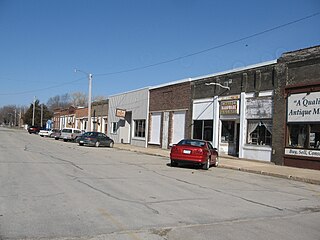
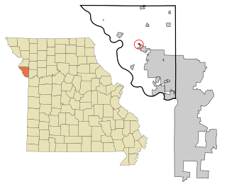
Miami is a city in Saline County, Missouri, United States. The population was 175 at the 2010 census.

<span class="mw-page-title-main">Branchville, South Carolina</span> Town in South Carolina, United States

Branchville is a town in Orangeburg County, South Carolina, United States. The population was 1,024 at the 2010 census.

<span class="mw-page-title-main">Farmington, West Virginia</span> Town in West Virginia, United States

Farmington is a town in Marion County, West Virginia, United States. The population was 389 at the 2020 census. The small town is situated on Buffalo Creek and the Allegheny Mountains about 6 miles west of Fairmont, Marion County's county seat. It is best known for being the site of the 1968 Farmington Mine disaster.

<span class="mw-page-title-main">Glen Dale, West Virginia</span> Town in West Virginia

Glen Dale is a city in Marshall County, West Virginia, United States, along the Ohio River. It is part of the Wheeling, West Virginia Metropolitan Statistical Area. The population was 1,514 at the 2020 census. Glen Dale was incorporated in 1924. It is in the northwest part of the county, which is above the Mason–Dixon line and forms the base of the Northern Panhandle of West Virginia.

<span class="mw-page-title-main">McMechen, West Virginia</span> City in West Virginia

McMechen is a city in Marshall County, West Virginia, United States, situated along the Ohio River. It is part of the Wheeling, West Virginia Metropolitan Statistical Area. The population was 1,714 at the 2020 census.

<span class="mw-page-title-main">Tunnelton, West Virginia</span> Town in West Virginia, United States

Tunnelton is a town in southwestern Preston County, West Virginia, United States. The population was 307 at the 2020 census. It is part of the Morgantown metropolitan area.

<span class="mw-page-title-main">Auburn, West Virginia</span> Town in West Virginia, United States

Auburn is a town in Ritchie County, West Virginia, United States. The population was 80 at the 2020 census.

<span class="mw-page-title-main">Pennsboro, West Virginia</span> City in West Virginia, United States

Pennsboro is a city in Ritchie County, West Virginia, United States. The population was 1,050 at the 2020 census. The city is located at the junction of U.S. Route 50 and West Virginia Route 74; the North Bend Rail Trail also passes through the city.

References

  1. "2019 U.S. Gazetteer Files". United States Census Bureau. Retrieved August 7, 2020.
  2. 1 2 3 4 "City and Town Population Totals: 2020-2021". Census.gov. US Census Bureau. Retrieved July 2, 2022.
  3. 1 2 "U.S. Census website". United States Census Bureau . Retrieved January 31, 2008.
  4. "US Board on Geographic Names". United States Geological Survey. October 25, 2007. Retrieved January 31, 2008.
  5. Capace, Nancy (1999). Encyclopedia of West Virginia. North American Book Dist LLC. p. 192. ISBN   978-0-403-09843-9.
  6. "US Gazetteer files: 2010, 2000, and 1990". United States Census Bureau. February 12, 2011. Retrieved April 23, 2011.
  7. DeLorme (1997). West Virginia Atlas & Gazetteer. Yarmouth, Maine: DeLorme. p.36. ISBN   0-89933-246-3.
  8. "US Gazetteer files 2010". United States Census Bureau. Archived from the original on July 2, 2012. Retrieved January 24, 2013.
  9. "Census of Population and Housing". Census.gov. Retrieved June 4, 2015.
  10. "U.S. Census website". United States Census Bureau . Retrieved January 24, 2013.