Peterstown, West Virginia

Last updated

Peterstown, West Virginia
Water Street - Peterstown, West Virginia - panoramio.jpg
Water Street in Peterstown
Monroe County West Virginia Incorporated and Unincorporated areas Peterstown Highlighted.svg
Location of Peterstown in Monroe County, West Virginia.
Coordinates: 37°23′55″N80°47′42″W / 37.39861°N 80.79500°W / 37.39861; -80.79500
Country United States
State West Virginia
County Monroe
Area
[1]
  Total0.32 sq mi (0.82 km2)
  Land0.32 sq mi (0.82 km2)
  Water0.00 sq mi (0.00 km2)
Elevation
1,624 ft (495 m)
Population
 (2020) [2]
  Total456
  Estimate 
(2021) [2]
454
  Density1,965.19/sq mi (757.68/km2)
Time zone UTC-5 (Eastern (EST))
  Summer (DST) UTC-4 (EDT)
ZIP code
24963
Area code 304
FIPS code 54-63052 [3]
GNIS feature ID1552465 [4]
Website local.wv.gov/peterstown/Pages/default.aspx

Peterstown is a town in Monroe County, West Virginia, United States. The population was 456 at the 2020 census. [2]

Contents

The town was named after Christian Peters, a pioneer settler. [5] The town is the site of the 1928 discovery of the 34.48 carat (6.896 g) Jones Diamond by Grover C. Jones and his son, William "Punch" Jones.

Geography

Peterstown is located at 37°23′55″N80°47′42″W / 37.398638°N 80.795102°W / 37.398638; -80.795102 (37.398638, -80.795102). It lies along the border with Virginia and is located directly across Rich Creek from Midway, Giles County, Virginia. [6]

According to the United States Census Bureau, the town has a total area of 0.32 square miles (0.83 km2), all land. [7]

Demographics

2020 population

With a 2020 population of 617, it is the 139th biggest city in West Virginia and the 12416th largest city in the U.S. Peterstown is currently declining at a rate of -0.32% annually and its population has decreased by -5.51% since the most recent census, which recorded a population of 653 in 2010

2010 census

At the 2010 census there were 653 people, 287 households, and 171 families living in the town. The population density was 2,040.6 inhabitants per square mile (787.9/km2). There were 333 housing units at an average density of 1,040.6 per square mile (401.8/km2). The racial makeup of the town was 97.9% White, 0.2% African American, 0.5% Native American, 0.5% from other races, and 1.1% from two or more races. Hispanic or Latino of any race were 0.6%. [8]

Of the 287 households 31.4% had children under the age of 18 living with them, 38.0% were married couples living together, 14.3% had a female householder with no husband present, 7.3% had a male householder with no wife present, and 40.4% were non-families. 36.9% of households were one person and 21.9% were one person aged 65 or older. The average household size was 2.28 and the average family size was 2.93.

The median age in the town was 36.4 years. 24.8% of residents were under the age of 18; 6.7% were between the ages of 18 and 24; 27.6% were from 25 to 44; 20.6% were from 45 to 64; and 20.2% were 65 or older. The gender makeup of the town was 47.8% male and 52.2% female.

2000 census

At the 2000 census there were 499 people, 253 households, and 138 families living in the town. The population density was 1,576.6 inhabitants per square mile (602.1/km2). There were 276 housing units at an average density of 872.0 per square mile (333.0/km2). The racial makeup of the town was 99.40% White, 0.20% from other races, and 0.40% from two or more races. Hispanic or Latino of any race were 1.00%. [3]

Of the 253 households 19.8% had children under the age of 18 living with them, 41.1% were married couples living together, 9.5% had a female householder with no husband present, and 45.1% were non-families. 42.3% of households were one person and 24.9% were one person aged 65 or older. The average household size was 1.97 and the average family size was 2.65.

The age distribution was 18.8% under the age of 18, 7.2% from 18 to 24, 21.4% from 25 to 44, 26.9% from 45 to 64, and 25.7% 65 or older. The median age was 47 years. For every 100 females, there were 84.8 males. For every 100 females age 18 and over, there were 80.0 males.

The median household income was $23,036 and the median family income was $32,250. Males had a median income of $38,542 versus $20,577 for females. The per capita income for the town was $16,964. About 13.3% of families and 17.8% of the population were below the poverty line, including 21.7% of those under age 18 and 18.8% of those age 65 or over.

Related Research Articles

<span class="mw-page-title-main">Burnsville, West Virginia</span> Town in West Virginia, United States

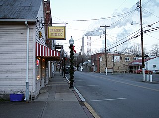
Burnsville is a town in Braxton County, West Virginia, United States, at the confluence of the Little Kanawha River and Saltlick Creek. The population was 401 at the 2020 census. Burnsville was incorporated in 1902 by the Circuit Court and named for Captain John Burns who operated the first sawmill in that section of the state and who established the town shortly after the close of the American Civil War. It was named "All West Virginia City" in 1976.

<span class="mw-page-title-main">Gassaway, West Virginia</span> Town in West Virginia, United States

Gassaway is a town in Braxton County, West Virginia, United States. The population was 769 at the 2020 census. Gassaway was incorporated in 1905 and named for Henry Gassaway Davis, the Democratic Party's nominee for Vice President of the United States in 1904. The center of population of West Virginia is located approximately 7 miles (11 km) north of Gassaway.

<span class="mw-page-title-main">Bethany, West Virginia</span> Town in West Virginia, United States

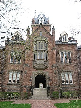
Bethany is a town in southern Brooke County, West Virginia, United States. The population was 756 at the 2020 census. It is part of the Weirton–Steubenville metropolitan area. It is best known as the home of Bethany College, a private liberal arts college that was the first institution of higher education in what is now West Virginia.

<span class="mw-page-title-main">Gauley Bridge, West Virginia</span> Town in West Virginia, United States

Gauley Bridge is a town in Fayette County, West Virginia, United States. The population was 614 at the 2010 census. The Kanawha River is formed at Gauley Bridge by the confluence of the New and Gauley Rivers. Two miles to the southwest of Gauley Bridge, in Glen Ferris, is Kanawha Falls, a popular stopping point on Midland Trail Scenic Highway.

<span class="mw-page-title-main">Anmoore, West Virginia</span> Town in West Virginia, United States

Anmoore is a town in Harrison County, West Virginia, United States. It is located at the intersection of WV 58 and Interstate 79. The population was 514 at the 2020 census.

<span class="mw-page-title-main">Lumberport, West Virginia</span> Town in West Virginia, United States

Lumberport is a town in Harrison County, located in northern West Virginia, United States. The population was 720 at the 2020 census.

<span class="mw-page-title-main">Stonewood, West Virginia</span> City in West Virginia, United States

Stonewood is a city in Harrison County, West Virginia, United States. The population was 1,810 at the 2020 census.

<span class="mw-page-title-main">West Milford, West Virginia</span> Town in West Virginia, United States

West Milford is a town in Harrison County, West Virginia, United States. The population was 452 at the 2020 census.

<span class="mw-page-title-main">Chesapeake, West Virginia</span> Town in West Virginia, United States

Chesapeake is a town in Kanawha County, West Virginia, United States. The population was 1,336 at the 2020 census. The town is situated on the Kanawha River.

<span class="mw-page-title-main">Fairview, West Virginia</span> Town in West Virginia, United States

Fairview is a town in Marion County, West Virginia, United States. The population was 374 at the 2020 census.

<span class="mw-page-title-main">White Hall, West Virginia</span> Town in West Virginia, United States

White Hall is a town in Marion County, West Virginia, United States. The population was 706 at the 2020 census. Incorporated in 1989, White Hall is adjacent to the county seat, Fairmont, and is part of the Fairmont, West Virginia, Micropolitan Statistical Area. White Hall has many different stores and restaurants.

<span class="mw-page-title-main">Worthington, West Virginia</span> Town in West Virginia, United States

Worthington is a town in Marion County, West Virginia, United States. The population was 158 at the 2010 census. Worthington was incorporated in 1893 and named for Colonel George Worthington, an early settler. U.S. Route 19 passes through the town.

<span class="mw-page-title-main">Mabscott, West Virginia</span> Town in West Virginia, United States

Mabscott is a town in Raleigh County, West Virginia, United States. The population was 1,333 at the 2020 census. The town's name is a contraction of the name Mabel Scott, wife of local coal operator Cyrus H. Scott.

<span class="mw-page-title-main">Rhodell, West Virginia</span> Unincorporated community in West Virginia, United States

Rhodell is an unincorporated community in Raleigh County, West Virginia, United States. The population was 173 at the 2010 census.

<span class="mw-page-title-main">Sophia, West Virginia</span> Town in West Virginia, United States

Sophia is a town in Raleigh County, West Virginia, United States. It was incorporated in 1912. The population was 1,124 at the 2020 census.

<span class="mw-page-title-main">Flemington, West Virginia</span> Town in West Virginia, United States

Flemington is a town in Taylor County, West Virginia, United States. The population was 311 at the 2020 census. Flemington was incorporated in 1922 by the West Virginia Circuit Court, and named for James Fleming, an early settler in the area originally from Hampshire County.

<span class="mw-page-title-main">Middlebourne, West Virginia</span> Town in West Virginia, United States

Middlebourne is a town and the county seat of Tyler County, West Virginia, United States. The population was 715 at the 2020 census.

<span class="mw-page-title-main">Pine Grove, West Virginia</span> Town in West Virginia, United States

Pine Grove is a town in Wetzel County, West Virginia, United States. The population was 363 at the 2020 census. The community was named for a grove of pine trees near the original town site.

<span class="mw-page-title-main">North Hills, West Virginia</span> Town in West Virginia, United States

North Hills is a town in Wood County, West Virginia, United States. It is a suburb of Parkersburg. The population was 837 at the 2020 census. North Hills was incorporated on February 15, 1979.

<span class="mw-page-title-main">Oceana, West Virginia</span> Town in West Virginia, United States

Oceana is a town in Wyoming County, West Virginia. The population was 1,462 at the time of the 2020 census. Oceana is the oldest city in Wyoming County and was the county seat until 1907.

References

  1. "2019 U.S. Gazetteer Files". United States Census Bureau. Retrieved August 7, 2020.
  2. 1 2 3 Bureau, US Census. "City and Town Population Totals: 2020-2021". Census.gov. US Census Bureau. Retrieved July 3, 2022.
  3. 1 2 "U.S. Census website". United States Census Bureau . Retrieved January 31, 2008.
  4. "US Board on Geographic Names". United States Geological Survey. October 25, 2007. Retrieved January 31, 2008.
  5. Kenny, Hamill (1945). West Virginia Place Names: Their Origin and Meaning, Including the Nomenclature of the Streams and Mountains. Piedmont, WV: The Place Name Press. p. 481.
  6. "US Gazetteer files: 2010, 2000, and 1990". United States Census Bureau. February 12, 2011. Retrieved April 23, 2011.
  7. "US Gazetteer files 2010". United States Census Bureau. Archived from the original on January 25, 2012. Retrieved January 24, 2013.
  8. "U.S. Census website". United States Census Bureau . Retrieved January 24, 2013.