Moorefield, West Virginia

Last updated

Moorefield, West Virginia
Hardy County Courthouse-Moorefield WV.jpg
Hardy County Courthouse in Moorefield
Seal of Moorefield, West Virginia.svg
Hardy County West Virginia Incorporated and Unincorporated areas Moorefield Highlighted.svg
Location of Moorefield in Hardy County, West Virginia.
Coordinates: 39°4′N78°58′W / 39.067°N 78.967°W / 39.067; -78.967
Country United States
State West Virginia
County Hardy
Government
  TypeMayor-council
  MayorTim Luttrell
Area
[1]
  Total2.77 sq mi (7.17 km2)
  Land2.72 sq mi (7.04 km2)
  Water0.05 sq mi (0.13 km2)
Elevation
810 ft (247 m)
Population
 (2020) [2]
  Total2,527
  Estimate 
(2021) [2]
2,487
  Density889.30/sq mi (343.37/km2)
Time zone UTC-5 (Eastern (EST))
  Summer (DST) UTC-4 (EDT)
ZIP code
26836
Area code 304
FIPS code 54-55588 [3]
GNIS feature ID1543520 [4]
Website Official website

Moorefield is a town and the county seat of Hardy County, West Virginia, United States. It is located at the confluence of the South Branch Potomac River and the South Fork South Branch Potomac River. Moorefield was originally chartered in 1777; it was named for Conrad Moore, who owned the land upon which the town was laid out. The population was 2,527 at the 2020 census. [2]

Contents

History

Aerial view of the business district of Moorefield, West Virginia. The U.S. Army Corps of Engineers has constructed levees along the South Fork to protect the town from flooding. Moorefield West Virginia aerial view.jpg
Aerial view of the business district of Moorefield, West Virginia. The U.S. Army Corps of Engineers has constructed levees along the South Fork to protect the town from flooding.
Aerial view of Moorefield and the surrounding terrain Moorefield aerial 2021.jpg
Aerial view of Moorefield and the surrounding terrain

Moorefield is situated in the South Branch Valley along the South Branch of the Potomac River. Native Americans populated this area for thousands of years. For centuries, they farmed along the river and hunted in the surrounding mountains. The historic Shawnee people, who spoke a Central Algonquian language in the same family as other tribes in their region, occupied this area when Anglo-European settlers began arriving in the early 18th century, attracted by the fertile land. This early settlement was centered on the community of Old Fields, referring to former Native American lands. This is located about five miles to the north of present-day Moorefield.

Conflict between the mostly British settlers and Native American peoples broke out during the French and Indian War. The British colonists constructed two fortifications to guard the South Branch Valley in the vicinity of Moorefield. Fort Buttermilk was erected in 1756 and garrisoned by Captain Thomas Waggoner's Virginia Regiment Company. [5] A second fortress, Fort Pleasant, situated at Henry Van Meter's Farm at Old Fields, guarded the northern side of the valley. It was also garrisoned by Waggoner's Virginia Regiment Company. [6] In the spring of 1756, soldiers from Forts Buttermilk and Pleasant clashed with Shawnee warriors under Bemino (also known as Killbuck) at the Battle of the Trough. [7]

Colonist Conrad Moore owned the land on which Moorefield was laid out. In 1777, the Virginia General Assembly chartered the town of Moorefield in what was then Hampshire County, Virginia (today Hardy County, West Virginia). [8] When Hardy County was separated from Hampshire County by act of the Virginia General Assembly in 1785, after the American Revolution, Moorefield was chosen as the county seat. [9] Many of the historic houses in Moorefield date to the last quarter of the 18th century and first quarter of the 19th century; they display vernacular adaptations of Federal and Greek Revival architecture.

During the American Civil War, Moorefield was the site of a cavalry engagement between Union Brigadier General William W. Averell and Confederate Brigadier General John McCausland on August 7, 1864, in which Averell routed McCausland. This was part of the Valley Campaigns of 1864. That summer, Averell was the only Union commander to achieve successes against Confederate forces.

Transportation

US 48 in Moorefield 2019-10-27 14 58 29 View west along U.S. Route 48 from the overpass for West Virginia State Route 55 in Moorefield, Hardy County, West Virginia.jpg
US 48 in Moorefield

The main highways serving Moorefield include U.S. Route 48, which traverses the region from west to east, and U.S. Route 220, which crosses from south to north through the area. West Virginia Route 55 and West Virginia Route 28 also serve Moorefield, but both mostly run concurrently with the aforementioned U.S. highways.

Geography

Moorefield is located at 39°4′N78°58′W / 39.067°N 78.967°W / 39.067; -78.967 (39.063, -78.966). [10]

According to the United States Census Bureau, the town has a total area of 2.40 square miles (6.22 km2), of which 2.35 square miles (6.09 km2) is land and 0.05 square miles (0.13 km2) is water. [11]

Climate

The climate in this area is characterized by hot, humid summers and generally mild to cool winters. According to the Köppen Climate Classification system, Moorefield has a humid subtropical climate, abbreviated "Cfa" on climate maps. [12]

Climate data for Moorefield, West Virginia (1991–2020 normals, extremes 1892–1933, 1947–1959, 1967–present)
MonthJanFebMarAprMayJunJulAugSepOctNovDecYear
Record high °F (°C)81
(27)
86
(30)
93
(34)
98
(37)
98
(37)
105
(41)
109
(43)
112
(44)
106
(41)
102
(39)
87
(31)
81
(27)
112
(44)
Mean daily maximum °F (°C)42.2
(5.7)
46.3
(7.9)
54.5
(12.5)
66.9
(19.4)
75.3
(24.1)
83.1
(28.4)
87.0
(30.6)
85.5
(29.7)
79.4
(26.3)
68.6
(20.3)
56.0
(13.3)
45.7
(7.6)
65.9
(18.8)
Daily mean °F (°C)31.3
(−0.4)
34.2
(1.2)
41.5
(5.3)
52.2
(11.2)
61.9
(16.6)
70.4
(21.3)
74.1
(23.4)
72.8
(22.7)
65.9
(18.8)
54.6
(12.6)
42.9
(6.1)
34.7
(1.5)
53.0
(11.7)
Mean daily minimum °F (°C)20.3
(−6.5)
22.1
(−5.5)
28.5
(−1.9)
37.6
(3.1)
48.5
(9.2)
57.6
(14.2)
61.3
(16.3)
60.1
(15.6)
52.4
(11.3)
40.6
(4.8)
29.8
(−1.2)
23.7
(−4.6)
40.2
(4.6)
Record low °F (°C)−27
(−33)
−25
(−32)
−9
(−23)
12
(−11)
25
(−4)
29
(−2)
39
(4)
38
(3)
27
(−3)
13
(−11)
−1
(−18)
−26
(−32)
−27
(−33)
Average precipitation inches (mm)2.17
(55)
1.71
(43)
2.86
(73)
3.09
(78)
3.78
(96)
3.69
(94)
4.37
(111)
3.26
(83)
3.45
(88)
2.47
(63)
2.04
(52)
2.30
(58)
44.02
(1,118)
Average snowfall inches (cm)6.6
(17)
4.9
(12)
4.2
(11)
0.0
(0.0)
0.0
(0.0)
0.0
(0.0)
0.0
(0.0)
0.0
(0.0)
0.0
(0.0)
0.0
(0.0)
0.8
(2.0)
4.9
(12)
21.4
(54)
Average precipitation days (≥ 0.01 in)7.66.89.210.712.310.810.49.98.47.66.97.6108.2
Average snowy days (≥ 0.1 in)2.31.91.20.00.00.00.00.00.00.00.21.47.0
Source: NOAA [13] [14]

Demographics

Historical population
CensusPop.Note
1880 554
1890 495−10.6%
1900 460−7.1%
1910 64640.4%
1920 630−2.5%
1930 73416.5%
1940 1,29175.9%
1950 1,4058.8%
1960 1,4342.1%
1970 2,12448.1%
1980 2,2576.3%
1990 2,148−4.8%
2000 2,37510.6%
2010 2,5447.1%
2020 2,527−0.7%
2021 (est.)2,487 [2] −1.6%
U.S. Decennial Census [15]

The median income for a household in the town was $24,178, and the median income for a family was $28,919. Males had a median income of $24,423 versus $17,917 for females. The per capita income for the town was $15,704. About 19.8% of families and 21.4% of the population were below the poverty line, including 31.2% of those under age 18 and 24.4% of those age 65 or over.

2010 census

As of the census [16] of 2010, there were 2,544 people, 1,097 households, and 624 families residing in the town. The population density was 1,082.6 inhabitants per square mile (418.0/km2). There were 1,216 housing units at an average density of 517.4 per square mile (199.8/km2). The racial makeup of the town was 79.0% White, 8.6% African American, 0.4% Native American, 4.7% Asian, 5.4% from other races, and 1.8% from two or more races. Hispanic or Latino of any race were 11.0% of the population.

There were 1,097 households, of which 27.5% had children under the age of 18 living with them, 37.5% were married couples living together, 13.8% had a female householder with no husband present, 5.7% had a male householder with no wife present, and 43.1% were non-families. 34.7% of all households were made up of individuals, and 15.1% had someone living alone who was 65 years of age or older. The average household size was 2.32 and the average family size was 2.90.

The median age in the town was 40.1 years. 20.1% of residents were under the age of 18; 9.5% were between the ages of 18 and 24; 27.2% were from 25 to 44; 26.7% were from 45 to 64; and 16.4% were 65 years of age or older. The gender makeup of the town was 50.9% male and 49.1% female.

Notable people

Related Research Articles

<span class="mw-page-title-main">Pendleton County, West Virginia</span> County in West Virginia, United States

Pendleton County is a county located in the U.S. state of West Virginia. As of the 2020 census, the population was 6,143, making it the second-least populous county in West Virginia. Its county seat is Franklin. The county was created by the Virginia General Assembly in 1788 from parts of Augusta, Hardy, and Rockingham counties and was named for Edmund Pendleton (1721–1803), a distinguished Virginia statesman and jurist. Pendleton County was strongly pro-Confederate during the American Civil War; however, there were pockets of Unionists who supported the state government in Wheeling.

<span class="mw-page-title-main">Mineral County, West Virginia</span> County in West Virginia, United States

Mineral County is a county in the U.S. state of West Virginia. It is part of the Cumberland metropolitan area, together with Cumberland, Maryland. As of the 2020 census, the population was 26,938. Its county seat is Keyser. The county was founded in 1866.

<span class="mw-page-title-main">Hardy County, West Virginia</span> County in West Virginia, United States

Hardy County is a county in the U.S. state of West Virginia. As of the 2020 census, the population was 14,299. Its county seat is Moorefield. The county was created from Hampshire County in 1786 and named for Samuel Hardy, a distinguished Virginian.

<span class="mw-page-title-main">Hampshire County, West Virginia</span> County in West Virginia, United States

Hampshire County is a county in the U.S. state of West Virginia. As of the 2020 census, the population was 23,093. Its county seat is Romney, West Virginia's oldest town (1762). The county was created by the Virginia General Assembly in 1754, from parts of Frederick and Augusta Counties (Virginia) and is the state's oldest county. The county lies in both West Virginia's Eastern Panhandle and Potomac Highlands regions.

<span class="mw-page-title-main">Berkeley County, West Virginia</span> County in West Virginia, United States

Berkeley County is located in the Shenandoah Valley in the eastern panhandle region of West Virginia in the United States. The county is part of the Hagerstown–Martinsburg metropolitan area. As of the 2020 census, the county population was 122,076, making it the second-most populous of West Virginia's 55 counties, behind Kanawha County. The City of Martinsburg is the county seat.

<span class="mw-page-title-main">Westernport, Maryland</span> Town in Maryland, United States

Westernport is a town in Allegany County, Maryland, United States, along the Georges Creek Valley. It is part of the Cumberland, MD-WV Metropolitan Statistical Area. The population was 1,888 at the 2010 census.

<span class="mw-page-title-main">Hedgesville, West Virginia</span> Town in West Virginia, United States

Hedgesville is a town in Berkeley County, West Virginia, United States, in the state's Eastern Panhandle region. The population was 318 at the 2010 census. The town sits on WV 9, roughly 13 miles east of Berkeley Springs. In addition to its legal definition, Hedgesville has come to be the common name for the large and sparsely inhabited area of West Virginia's Eastern Panhandle bordered by the Potomac River to the North and East, a southern border defined roughly by an imaginary line from the city of Martinsburg to the tip of Virginia, and Berkeley Springs to the West.

<span class="mw-page-title-main">Glenville, West Virginia</span> Town in West Virginia, United States

Glenville is a town in and the county seat of Gilmer County, West Virginia, United States, along the Little Kanawha River. The population was 1,128 at the 2020 census. It is the home of Glenville State University.

<span class="mw-page-title-main">Bayard, West Virginia</span> Town in West Virginia, United States

Bayard is a town in Grant County, West Virginia, United States. The population was 200 at the 2020 census. Bayard was incorporated in 1893 and named in honor of Thomas F. Bayard, Jr., who later became a United States senator from Delaware (1923–1929). Bayard was founded on the West Virginia Central and Pittsburgh Railroad as a coal mining community. Coal mining has remained the town's chief industry.

<span class="mw-page-title-main">Petersburg, West Virginia</span> City in West Virginia, United States

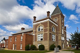
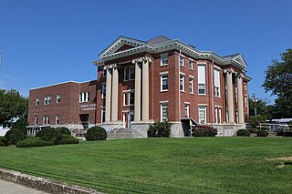
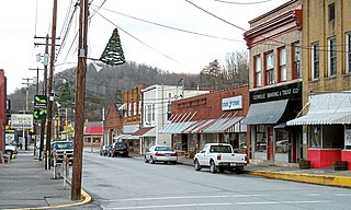
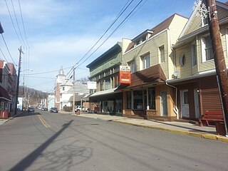
Petersburg is a city in Grant County, West Virginia, United States. The population was 2,251 at the 2020 census. It is the county seat of Grant County.

<span class="mw-page-title-main">Romney, West Virginia</span> Town in West Virginia, United States

Romney is a town in and the county seat of Hampshire County, West Virginia, United States. The population was 1,722 at the 2020 census. It is part of the Winchester, Virginia metropolitan area. The town was established in 1762 along with Shepherdstown; together, they are the two oldest towns in West Virginia.

<span class="mw-page-title-main">Wardensville, West Virginia</span> Town in West Virginia, United States

Wardensville is a town in Hardy County, West Virginia, United States. The population was 265 at the 2020 census. Originally named Trout Run, Wardensville was chartered in Virginia in 1832 and incorporated in West Virginia in 1879. Wardensville is located west of the Great North Mountain range, which separates it from the Shenandoah Valley. The town lies on the east bank of the Cacapon River at its confluence with Trout Run. The George Washington and Jefferson National Forests border the town to its east and south.

<span class="mw-page-title-main">Athens, West Virginia</span> Town in West Virginia, United States

Athens is a town in Mercer County, West Virginia, United States. The population was 944 at the 2020 census. It is part of the Bluefield, WV-VA micropolitan area which has a population of 107,578. Athens is the home of Concord University.

<span class="mw-page-title-main">Carpendale, West Virginia</span> Town in West Virginia, United States

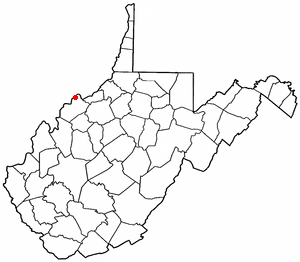
Carpendale is a town in Mineral County, West Virginia, United States, and part of the Cumberland, MD-WV Metropolitan Statistical Area'. The population was 861 at the 2020 census. Carpendale was incorporated on January 2, 1990, by the Circuit Court. The town is a combination of three subdivisions of which its name reflects: Carpenters Addition, Millerdale I, and Millerdale II. There are no stores in Carpendale and there is only one road in and out of the town.

<span class="mw-page-title-main">Keyser, West Virginia</span> City in West Virginia, United States

Keyser is a city in and the county seat of Mineral County, West Virginia. It is part of the Cumberland, MD-WV Metropolitan Statistical Area. The population was 4,853 at the 2020 census.

<span class="mw-page-title-main">Piedmont, West Virginia</span> Town in West Virginia, United States

Piedmont is a town in Mineral County, West Virginia, United States. It is part of the Cumberland, MD-WV metropolitan statistical area. The population was 716 at the 2020 census. Piedmont was chartered in 1856 and the town is the subject of Colored People: A Memoir by Piedmont native Henry Louis Gates Jr.

<span class="mw-page-title-main">Ridgeley, West Virginia</span> Town in West Virginia, United States

Ridgeley is a town in Mineral County, West Virginia, United States, and part of the Cumberland Metropolitan Statistical Area. The population was 590 at the 2020 census.

<span class="mw-page-title-main">Paw Paw, West Virginia</span> Town in West Virginia, United States

Paw Paw is a town in Morgan County, West Virginia, United States. The population was 410 at the 2020 census. The town is known for the nearby Paw Paw Tunnel. Paw Paw was incorporated by the Circuit Court of Morgan County on April 8, 1891, and named after pawpaw, a wild fruit that grows in abundance throughout this region. Paw Paw is the westernmost incorporated community in Morgan County, and the Hagerstown-Martinsburg, MD-WV Metropolitan Statistical Area.

<span class="mw-page-title-main">Buckhannon, West Virginia</span> City in West Virginia, United States

Buckhannon is the only incorporated city in, and the county seat of, Upshur County, West Virginia, United States. Located along the Buckhannon River, the population was 5,299 as of the 2020 census. The city is 46 miles (74 km) southwest of Morgantown, 88 miles (142 km) northeast of the capital city of Charleston, and 100 miles (160 km) south of Pittsburgh, Pennsylvania. It is home to West Virginia Wesleyan College and the West Virginia Strawberry Festival, held annually during the third week of May.

<span class="mw-page-title-main">Boaz, West Virginia</span> CDP in West Virginia, United States

Boaz is a census-designated place (CDP) in Wood County, West Virginia, United States. It is part of the Parkersburg-Marietta-Vienna, WV-OH Metropolitan Statistical Area. As of the 2020 census, the CDP population was 1,321.

References

  1. "2019 U.S. Gazetteer Files". United States Census Bureau. Retrieved August 7, 2020.
  2. 1 2 3 4 "City and Town Population Totals: 2020-2021". Census.gov. US Census Bureau. Retrieved July 3, 2022.
  3. "U.S. Census website". United States Census Bureau . Retrieved January 31, 2008.
  4. "US Board on Geographic Names". United States Geological Survey. October 25, 2007. Retrieved January 31, 2008.
  5. McBride, Stephen; McBride, Kim. "Fort Buttermilk". e-WV. The West Virginia Encyclopedia. Retrieved February 24, 2016.
  6. Adamson, Greg. "Fort Pleasant". e-WV. The West Virginia Encyclopedia. Retrieved February 24, 2016.
  7. Stoetzel, Donald I. (2008). Encyclopedia of the French & Indian War in North America, 1754–1763. Heritage Books. ISBN   978-0-7884-4517-0.
  8. Heishman, Phoebe. "Moorefield". e-WV. The West Virginia Encyclopedia. Retrieved February 24, 2016.
  9. Heishman, Phoebe. "Hardy County". e-WV. The West Virginia Encyclopedia. Retrieved February 24, 2016.
  10. "US Gazetteer files: 2010, 2000, and 1990". United States Census Bureau. February 12, 2011. Retrieved April 23, 2011.
  11. "US Gazetteer files 2010". United States Census Bureau. Archived from the original on July 2, 2012. Retrieved January 24, 2013.
  12. Climate Summary for Moorefield, West Virginia
  13. "NOWData - NOAA Online Weather Data". National Oceanic and Atmospheric Administration. Retrieved October 13, 2023.
  14. "Summary of Monthly Normals 1991-2020". National Oceanic and Atmospheric Administration. Retrieved October 13, 2023.
  15. "Census of Population and Housing". Census.gov. Retrieved June 4, 2015.
  16. "U.S. Census website". United States Census Bureau . Retrieved January 24, 2013.