Jane Lew, West Virginia

Last updated

Jane Lew, West Virginia
Jane Lew West Virginia.JPG
Main Avenue (U.S. Route 19) in Jane Lew in 2006
Logo of Jane Lew, West Virginia.svg
Lewis County West Virginia Incorporated and Unincorporated areas Jane Lew Highlighted.svg
Location of Jane Lew in Lewis County, West Virginia.
Coordinates: 39°6′33″N80°24′27″W / 39.10917°N 80.40750°W / 39.10917; -80.40750
Country United States
State West Virginia
County Lewis
Government
  TypeMayoral
  MayorRuth Straley
Area
[1]
  Total0.25 sq mi (0.64 km2)
  Land0.24 sq mi (0.62 km2)
  Water0.01 sq mi (0.02 km2)
Elevation
1,017 ft (310 m)
Population
 (2020) [2]
  Total409
  Estimate 
(2021) [2]
406
  Density1,615.06/sq mi (624.51/km2)
Time zone UTC-5 (Eastern (EST))
  Summer (DST) UTC-4 (EDT)
ZIP code
26378
Area code 304
FIPS code 54-40828 [3]
GNIS feature ID1540818 [4]
Website townofjanelew.com

Jane Lew is a town in Lewis County, West Virginia, United States. The population was 409 at the time of the 2020 census. [2]

Contents

History

The community was named after Jane Lew, the mother of the original owner of the town site. [5]

Geography

Jane Lew is located at 39°6′33″N80°24′27″W / 39.10917°N 80.40750°W / 39.10917; -80.40750 (39.109203, -80.407624), [6] along Hackers Creek in northern Lewis County. [7]

According to the United States Census Bureau, the town has a total area of 0.25 square miles (0.65 km2), of which 0.24 square miles (0.62 km2) is land and 0.01 square miles (0.03 km2) is water. [8]

Demographics

Historical population
CensusPop.Note
1880 142
1890 22860.6%
1910 327
1920 56071.3%
1930 445−20.5%
1940 50513.5%
1950 491−2.8%
1960 426−13.2%
1970 397−6.8%
1980 4062.3%
1990 4398.1%
2000 406−7.5%
2010 4090.7%
2020 4090.0%
2021 (est.)406 [2] −0.7%
U.S. Decennial Census [9]

2010 census

As of the census [10] of 2010, there were 409 people, 195 households, and 111 families living in the town. The population density was 1,704.2 inhabitants per square mile (658.0/km2). There were 213 housing units at an average density of 887.5 per square mile (342.7/km2). The racial makeup of the town was 98.8% White, 0.2% Native American, 0.2% Asian, and 0.7% from two or more races. Hispanic or Latino of any race were 0.2% of the population.

There were 195 households, of which 24.1% had children under the age of 18 living with them, 42.6% were married couples living together, 10.8% had a female householder with no husband present, 3.6% had a male householder with no wife present, and 43.1% were non-families. 38.5% of all households were made up of individuals, and 19% had someone living alone who was 65 years of age or older. The average household size was 2.10 and the average family size was 2.72.

The median age in the town was 41.8 years. 19.3% of residents were under the age of 18; 8.2% were between the ages of 18 and 24; 24.5% were from 25 to 44; 30.5% were from 45 to 64; and 17.6% were 65 years of age or older. The gender makeup of the town was 47.4% male and 52.6% female.

2000 census

As of the census [3] of 2000, there were 406 people, 209 households, and 117 families living in the town. The population density was 1,635.2 inhabitants per square mile (627.0/km2). There were 220 housing units at an average density of 886.1 per square mile (339.8/km2). The racial makeup of the town was 98.03% White, 0.25% Native American, and 1.72% from two or more races. Hispanic or Latino of any race were 1.23% of the population.

There were 209 households, out of which 17.7% had children under the age of 18 living with them, 40.7% were married couples living together, 11.0% had a female householder with no husband present, and 44.0% were non-families. 40.7% of all households were made up of individuals, and 18.7% had someone living alone who was 65 years of age or older. The average household size was 1.94 and the average family size was 2.58.

In the town, the population was spread out, with 15.0% under the age of 18, 7.9% from 18 to 24, 28.8% from 25 to 44, 24.6% from 45 to 64, and 23.6% who were 65 years of age or older. The median age was 44 years. For every 100 females, there were 84.5 males. For every 100 females age 18 and over, there were 79.7 males.

The median income for a household in the town was $23,571, and the median income for a family was $30,000. Males had a median income of $29,464 versus $16,667 for females. The per capita income for the town was $16,540. About 5.3% of families and 7.9% of the population were below the poverty line, including 2.9% of those under age 18 and 11.5% of those age 65 or over.

Notable people

Climate

The climate in this area is characterized by relatively high temperatures and evenly distributed precipitation throughout the year. According to the Köppen Climate Classification system, Jane Lew has a Humid subtropical climate, abbreviated "Cfa" on climate maps. [11]

Climate data for Jane Lew, West Virginia
MonthJanFebMarAprMayJunJulAugSepOctNovDecYear
Mean daily maximum °C (°F)9
(48)
9
(48)
13
(55)
19
(67)
25
(77)
29
(84)
32
(89)
30
(86)
28
(82)
21
(70)
14
(57)
9
(48)
20
(68)
Mean daily minimum °C (°F)−4
(24)
−4
(24)
−2
(29)
3
(38)
8
(47)
13
(56)
16
(60)
15
(59)
12
(54)
4
(40)
0
(32)
−3
(26)
5
(41)
Average precipitation mm (inches)91
(3.6)
76
(3)
97
(3.8)
94
(3.7)
110
(4.2)
120
(4.6)
110
(4.5)
110
(4.5)
89
(3.5)
71
(2.8)
76
(3)
81
(3.2)
1,130
(44.5)
Source: Weatherbase [12]

Education

Jane Lew Elementary School. Jane Lew used to have a high school in operation (Jane Lew High School) from 1912 until 1966, when it consolidated with two another local schools to make Lewis County High School. Jane Lew High also won a West Virginia state boys basketball championship in 1922.

Related Research Articles

<span class="mw-page-title-main">Gantt, Alabama</span> Town in Alabama, United States

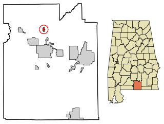
Gantt is a town in Covington County, Alabama, United States. At the 2020 census, the population was 196.

<span class="mw-page-title-main">Palmyra, Indiana</span> Town in Indiana, United States

Palmyra is a town in Morgan Township, Harrison County, Indiana, United States. The population was 930 at the 2010 census.

<span class="mw-page-title-main">Steamboat Rock, Iowa</span> City in Iowa, United States

Steamboat Rock is a city in Hardin County, Iowa, United States. The population was 264 at the time of the 2020 census.

<span class="mw-page-title-main">Belington, West Virginia</span> City in West Virginia

Belington is a town in Barbour County, West Virginia, United States, situated along the Tygart Valley River. The population was 1,804 as of the 2020 census.

<span class="mw-page-title-main">Burnsville, West Virginia</span> Town in West Virginia, United States

Burnsville is a town in Braxton County, West Virginia, United States, at the confluence of the Little Kanawha River and Saltlick Creek. The population was 401 at the 2020 census. Burnsville was incorporated in 1902 by the Circuit Court and named for Captain John Burns who operated the first sawmill in that section of the state and who established the town shortly after the close of the American Civil War. It was named "All West Virginia City" in 1976.

<span class="mw-page-title-main">Grantsville, West Virginia</span> Town in West Virginia, United States

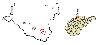
Grantsville is a town in Calhoun County, West Virginia, United States. The population was 482 at the 2020 census. It is the county seat of Calhoun County. The town was established along the Little Kanawha River in 1865 and named for Ulysses S. Grant. Grantsville is home to Wayne Underwood Park, which includes a .25-mile-long (0.40 km) walking trail, and to the annual West Virginia Wood Festival.

<span class="mw-page-title-main">Bayard, West Virginia</span> Town in West Virginia, United States

Bayard is a town in Grant County, West Virginia, United States. The population was 200 at the 2020 census. Bayard was incorporated in 1893 and named in honor of Thomas F. Bayard, Jr., who later became a United States senator from Delaware (1923–1929). Bayard was founded on the West Virginia Central and Pittsburgh Railroad as a coal mining community. Coal mining has remained the town's chief industry.

<span class="mw-page-title-main">Man, West Virginia</span> Town in West Virginia, United States

Man is a town in Logan County, West Virginia, United States. The population was 772 at the 2020 census. The town is located along the Guyandotte River at the mouth of Buffalo Creek, which was the site of the 1972 Buffalo Creek Flood following a dam collapse. The name of the town reportedly derives from the last syllable of the surname of Ulysses Hinchman, who was a member of the House of Delegates from Logan County between 1866 and 1869.

<span class="mw-page-title-main">Iaeger, West Virginia</span> Town in West Virginia, United States

Iaeger is a town in McDowell County, West Virginia, United States. The population was 257 at the 2020 census.

<span class="mw-page-title-main">Matoaka, West Virginia</span> Census-designated place in West Virginia, United States

Matoaka is a census-designated place in Mercer County, West Virginia, United States. The population was 173 at the 2020 census. It is part of the Bluefield, WV-VA micropolitan area which has a population of 100,093. This town is named for Chief Powhatan's daughter Matoaka who was better known by her nickname "Pocahontas". Matoaka became an unincorporated town when it voted to dissolve its charter in May 2018.

<span class="mw-page-title-main">Granville, West Virginia</span> Town in West Virginia

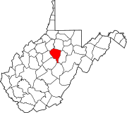
Granville is a town in Monongalia County, West Virginia, United States. The population was 1,355 at the 2020 census. It is included in the Morgantown metropolitan area.

<span class="mw-page-title-main">Albright, West Virginia</span> Town in West Virginia, United States

Albright is a town in central Preston County, West Virginia, United States, along the Cheat River. The population was 260 at the 2020 census. A former coal town, it is part of the Morgantown metropolitan area.

<span class="mw-page-title-main">Bruceton Mills, West Virginia</span> Town in West Virginia, United States

Bruceton Mills is a town in northern Preston County, West Virginia, United States, along Big Sandy Creek. The population was 64 at the 2020 census, making it the second-least populous town in West Virginia, after Thurmond. It is part of the Morgantown metropolitan area.

<span class="mw-page-title-main">Eleanor, West Virginia</span> Town in West Virginia, United States

Eleanor is a town in Putnam County, West Virginia, United States, along the Kanawha River. Its population was 1,548 at the 2020 census. It is part of the Huntington–Ashland metropolitan area. The town, named for Eleanor Roosevelt, was established as a New Deal project in the 1930s like other Franklin D. Roosevelt towns around the nation.

<span class="mw-page-title-main">Huttonsville, West Virginia</span> Town in West Virginia, United States

Huttonsville is a town in Randolph County, West Virginia, United States, along the Tygart Valley River. The population was 163 at the 2020 census.

<span class="mw-page-title-main">Cairo, West Virginia</span> Town in West Virginia, United States

Cairo is a town in Ritchie County, West Virginia, United States, along West Virginia Route 31, the North Fork of the Hughes River, and the North Bend Rail Trail. The population was 174 at the 2020 census.

<span class="mw-page-title-main">Hambleton, West Virginia</span> Town in West Virginia, United States

Hambleton is a town in Tucker County, West Virginia, United States. The population was 216 at the 2020 census. Hambleton was established in 1889, but not incorporated until 1905. It was named by then United States Senator Stephen B. Elkins in honor of a stockholder by this name in the West Virginia Central Railroad Company. The town was previously known as Hulings.

<span class="mw-page-title-main">Smithfield, West Virginia</span> Town in West Virginia, United States

Smithfield is a town in Wetzel County, West Virginia, United States. The population was 103 at the 2020 census.

<span class="mw-page-title-main">Elizabeth, West Virginia</span> Town in West Virginia, United States

Elizabeth is a town in and the county seat of Wirt County, West Virginia, United States, situated along the Little Kanawha River. The population was 724 as of the 2020 census.

<span class="mw-page-title-main">Oceana, West Virginia</span> Town in West Virginia, United States

Oceana is a town in Wyoming County, West Virginia. The population was 1,462 at the time of the 2020 census. Oceana is the oldest city in Wyoming County and was the county seat until 1907.

References

  1. "2019 U.S. Gazetteer Files". United States Census Bureau. Retrieved August 7, 2020.
  2. 1 2 3 4 "City and Town Population Totals: 2020-2021". Census.gov. US Census Bureau. Retrieved July 3, 2022.
  3. 1 2 "U.S. Census website". United States Census Bureau . Retrieved January 31, 2008.
  4. "US Board on Geographic Names". United States Geological Survey. October 25, 2007. Retrieved January 31, 2008.
  5. Kenny, Hamill (1945). West Virginia Place Names: Their Origin and Meaning, Including the Nomenclature of the Streams and Mountains. Piedmont, WV: The Place Name Press. p. 333.
  6. "US Gazetteer files: 2010, 2000, and 1990". United States Census Bureau. February 12, 2011. Retrieved April 23, 2011.
  7. DeLorme (1997). West Virginia Atlas & Gazetteer. Yarmouth, Maine: DeLorme. p.36. ISBN   0-89933-246-3.
  8. "US Gazetteer files 2010". United States Census Bureau. Archived from the original on July 2, 2012. Retrieved January 24, 2013.
  9. "Census of Population and Housing". Census.gov. Retrieved June 4, 2015.
  10. "U.S. Census website". United States Census Bureau . Retrieved January 24, 2013.
  11. Climate Summary for Jane Lew, West Virginia
  12. "Weatherbase.com". Weatherbase. 2013. Retrieved on September 15, 2013.