
Montgomery County is the most populous county in the U.S. state of Maryland. As of the 2020 census, the county's population was 1,062,061, increasing by 9.3% from 2010. The county seat is Rockville and Germantown is the most populous place in the county. The county is adjoined to Washington, D.C., the nation's capital, and is part of the Washington metropolitan area and the Washington–Baltimore combined statistical area. Most of the county's residents live in Silver Spring, Bethesda, Germantown, and the incorporated cities of Rockville and Gaithersburg.

Brookeville is a town in Montgomery County, Maryland, located 20 km (12 mi) north of Washington, D.C., and 2 km (1.2 mi) north of Olney. Brookeville was settled by Quakers late in the 18th century and was incorporated as a town in 1808. Historically a farming town, Brookeville is now at the northern edge of the densely developed Washington suburbs. The population was 166 at the 2020 census.

Darnestown is a United States census-designated place (CDP) and an unincorporated area in Montgomery County, Maryland. The CDP is 17.70 square miles (45.8 km2) with the Potomac River as its southern border and the Muddy Branch as much of its eastern border. Seneca Creek borders portions of its north and west sides. The Travilah, North Potomac, and Germantown census-designated places are adjacent to it, as is the city of Gaithersburg. Land area for the CDP is 16.39 square miles (42.4 km2). As of the 2020 census, the Darnestown CDP had a population of 6,723, while the village of Darnestown is considerably smaller in size and population. Downtown Washington, D.C. is about 22 miles (35 km) to the southeast.

Laytonsville is a town in Montgomery County, Maryland, United States. The population was 572 at the 2020 census, up from 353 in 2010. Laytonsville was incorporated in 1892.

North Bethesda is an unincorporated, census-designated place (CDP) in Montgomery County, Maryland, United States, located just north-west of the U.S. capital of Washington, D.C. It had a population of 50,094 as of the 2020 census. Among its neighborhoods, the centrally-located, urbanizing district of White Flint is the commercial and residential hub of North Bethesda. The Pike & Rose development and the Pike District is an initiative of Montgomery County to brand and market this region as "North Bethesda's Urban Core". The WMATA North Bethesda metro station and Grosvenor-Strathmore metro station serve the region.

North Potomac is a census-designated place and unincorporated area in Montgomery County, Maryland, United States. It is located less than 5 miles (8.0 km) north of the Potomac River, and is about 20 miles (32 km) from Washington, D.C. It has a population of 23,790 as of 2020.

Travilah is a United States census-designated place and an unincorporated area in Montgomery County, Maryland. It is 17.28 square miles (44.8 km2) located along the north side of the Potomac River, and surrounded by the communities of Potomac, North Potomac, and Darnestown—all census-designated places. It had a population of 11,985 as of the 2020 census.

Sandy Spring is an unincorporated community in Montgomery County, Maryland, United States.

The Washington–Baltimore combined metropolitan statistical area is a statistical area including the overlapping metropolitan areas of Washington, D.C. and Baltimore. The region includes Central Maryland, Northern Virginia, three counties in the Eastern Panhandle of West Virginia, and one county in south-central Pennsylvania. It is the most educated, highest-income, and third-most populous combined statistical area in the United States behind New York City–Newark, NJ and Los Angeles–Long Beach.

Glenmont is an unincorporated community and census-designated place in Montgomery County, Maryland, United States. The United States Census Bureau had combined Glenmont with nearby Wheaton to create the census-designated place of Wheaton-Glenmont, from 2000 to 2010. It had a population of 16,710 in 2020.

Maryland Route 198 is a state highway in the U.S. state of Maryland. The highway runs 14.14 miles (22.76 km) from MD 650 near Spencerville east to the entrance of Fort George G. Meade beyond its junction with MD 32. MD 198 connects Laurel in far northern Prince George's County with the northeastern Montgomery County communities of Spencerville and Burtonsville and Maryland City and Fort Meade in western Anne Arundel County. The highway is a four-to-six-lane divided highway between U.S. Route 29 in Burtonsville and the Baltimore–Washington Parkway in Maryland City.

Maryland Route 108 is a state highway in the U.S. state of Maryland. The highway runs 34.23 miles (55.09 km) from MD 27 in Damascus east to MD 175 in Columbia. MD 108 is an S-shaped highway that winds through northern Montgomery County and central Howard County. The highway connects the Montgomery County communities of Laytonsville, Olney, Sandy Spring, and Ashton with the Howard County villages of Highland and Clarksville. MD 108 serves as the northern edge of Columbia and connects several of the planned community's suburban villages.

Maryland Route 195 is a state highway in the U.S. state of Maryland. Known as Carroll Avenue, the state highway runs 1.90 miles (3.06 km) from Eastern Avenue at the District of Columbia boundary in Takoma Park north to MD 193 in Silver Spring. MD 195 is the main north–south state highway through Takoma Park in southeastern Montgomery County. The highway provides access to Washington Adventist University and Washington Adventist Hospital and crosses Sligo Creek on the Carroll Avenue Bridge. The state highway was constructed from Washington, D.C. to Silver Spring in the late 1920s on a road that has existed since the 19th century. The Carroll Avenue Bridge was built in 1932 as the third bridge at the site. Reconstruction of the bridge began in 2015 and was completed in 2017.

Maryland Route 650 is a state highway in the U.S. state of Maryland. Known as New Hampshire Avenue for most of its length, the state highway runs 25.89 mi (41.67 km) from Eastern Avenue at the Washington, D.C. border north to MD 108 in Etchison. MD 650 serves as a major north-south commuter route in northwestern Prince George's County and eastern Montgomery County, connecting the District of Columbia with the residential suburbs of Takoma Park, Langley Park, Adelphi, Hillandale, White Oak, and Colesville. By contrast, the part of MD 650 north of Spencerville is a quiet rural road connecting several small communities along the northeastern fringe of Montgomery County.
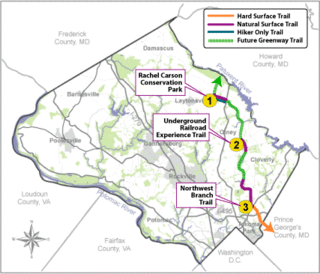
The Rachel Carson Greenway is a planned 25-mile stretch of trails, spanning from the historic Adelphi Mill in Prince George's County north through eastern Montgomery County, Maryland to Patuxent River State Park, and incorporating existing Northwest Branch trails. The greenway was proposed as part of a 1998 Countywide Park Trails Plan. A plan for the greenway was approved by the Montgomery County Planning Board on June 15, 2005.
Highland is an unincorporated community and census-designated place in Howard County, Maryland, United States. As of the 2020 census it had a population of 1,133. It uses the 20777 zip code.
Maryland Route 28 is a state highway in the U.S. state of Maryland. The state highway runs 37.38 miles (60.16 km) from U.S. Route 15 in Point of Rocks east to MD 182 in Norwood. The western portion of MD 28 is a rural highway connecting several villages in southern Frederick County and western Montgomery County. By contrast, the eastern portion of the state highway is a major east–west commuter route, particularly within Gaithersburg and Rockville.

U.S. Route 29 (US 29) is a north–south United States Numbered Highway that runs for 1,043.3 miles (1,679.0 km) from Pensacola, Florida, to the western suburbs of Baltimore, Maryland. In the U.S. state of Maryland, US 29 is a major highway that emerges from Washington DC and runs north into eastern Montgomery County, stretching over 25.86 miles (41.62 km) through the state and terminating at Maryland Route 99 (MD 99) outside of Ellicott City. It serves the cities of Columbia and Ellicott City and provides the westernmost north–south route between Washington DC and Baltimore.
Maryland Route 182 is a state highway in the U.S. state of Maryland. Known for most of its length as Layhill Road, the highway runs 6.54 miles (10.53 km) from MD 97 in Glenmont north to MD 108 in Olney. MD 182 connects the northeastern Montgomery County communities of Glenmont, Layhill, Norwood, Sandy Spring, and Olney. The highway was constructed in the early 1920s. MD 182 was expanded to a four-lane divided highway from Glenmont to the site of its interchange with MD 200 in the late 1980s and early 1990s.
Brinklow is an unincorporated community in Montgomery County, Maryland, United States. Brinklow is located on Maryland Route 650, 3 miles (4.8 km) northeast of Olney. Brinklow has a post office with ZIP code 20862. It is located within the Ashton-Sandy Spring census-designated place for statistical purposes.

