Pawnee, Illinois

Last updated

Pawnee
Sangamon County Illinois Incorporated and Unincorporated areas Pawnee Highlighted.svg
Location of Pawnee in Sangamon County, Illinois.
Illinois in United States (US48).svg
Location of Illinois in the United States
Coordinates: 39°35′31″N89°34′55″W / 39.59194°N 89.58194°W / 39.59194; -89.58194
CountryUnited States
StateIllinois
County Sangamon
Government
  BodyBoard of Trustees of the Village of Pawnee
  MayorJeff Clarke
Area
[1]
  Total1.33 sq mi (3.45 km2)
  Land1.33 sq mi (3.45 km2)
  Water0.00 sq mi (0.00 km2)
Elevation
603 ft (184 m)
Population
 (2020)
  Total2,678
  Density2,010.51/sq mi (776.33/km2)
Time zone UTC-6 (CST)
  Summer (DST) UTC-5 (CDT)
ZIP Code(s)
62558
Area code 217
FIPS code 17-58174
Wikimedia CommonsPawnee, Illinois
Website www.pawneeil.net

Pawnee is a village in Sangamon County, Illinois, United States. Its population was 2,739 at the 2010 census, and 2,651 at a 2018 estimate. It is part of the Springfield, Illinois Metropolitan Statistical Area.

Contents

History

The community is named after the Pawnee Tribe. [2] On August 6, 2023, a large and long-tracked EF2 tornado hit north of Pawnee, Illinois destroying houses and businesses.


On 13 October 1902 the Victor Mine exploded killing six workers. Press reports indicate an explosive charge ignited coal dust in the shaft. [3]

Geography

Pawnee is located at 39°35′31″N89°34′55″W / 39.59194°N 89.58194°W / 39.59194; -89.58194 (39.592050, -89.582012). [4]

According to the 2010 census, Pawnee has a total area of 1.26 square miles (3.26 km2), all land. [5]

Demographics

Historical population
CensusPop.Note
1880 192
1900 595
1910 1,399135.1%
1920 1,200−14.2%
1930 959−20.1%
1940 1,0064.9%
1950 974−3.2%
1960 1,51755.7%
1970 1,93627.6%
1980 2,57733.1%
1990 2,384−7.5%
2000 2,64711.0%
2010 2,7393.5%
2020 2,678−2.2%
U.S. Decennial Census [6]

At the 2000 census there were 2,647 people, 1,028 households, and 747 families in the village. The population density was 2,221.0 inhabitants per square mile (857.5/km2). There were 1,086 housing units at an average density of 911.2 per square mile (351.8/km2). The racial makeup of the village was 98.83% White, 0.15% African American, 0.11% Native American, 0.19% Asian, 0.04% from other races, and 0.68% from two or more races. Hispanic or Latino of any race were 0.30%. [7]

Of the 1,028 households 40.0% had children under the age of 18 living with them, 59.0% were married couples living together, 10.6% had a female householder with no husband present, and 27.3% were non-families. 23.4% of households were one person and 12.5% were one person aged 65 or older. The average household size was 2.57 and the average family size was 3.06.

The age distribution was 28.1% under the age of 18, 6.8% from 18 to 24, 31.8% from 25 to 44, 21.7% from 45 to 64, and 11.5% 65 or older. The median age was 35 years. For every 100 females, there were 92.8 males. For every 100 females age 18 and over, there were 85.6 males.

The median household income was $50,787 and the median family income was $54,736. Males had a median income of $37,171 versus $26,304 for females. The per capita income for the village was $21,599. About 5.9% of families and 6.3% of the population were below the poverty line, including 7.6% of those under age 18 and 8.5% of those age 65 or over.

Pawnee is loosely represented in the video game Watch Dogs , though the geographic position is quite different. Due to contiguous map size constraints in the open-world game, Pawnee is shown to be relatively close to Chicago; however, it is actually located nearer to the center of Illinois, far from Chicago.

Related Research Articles

<span class="mw-page-title-main">Watson, Illinois</span> Village in Illinois, United States

Watson is a village in Effingham County, Illinois, United States. The population was 668 at the 2020 census. Watson is part of the Effingham, IL Micropolitan Statistical Area.

<span class="mw-page-title-main">Vergennes, Illinois</span> Village in Illinois, United States

Vergennes is a village in Jackson County, Illinois, United States. The population was 298 at the 2010 census, down from 491 at the 2000 census.

<span class="mw-page-title-main">San Jose, Illinois</span> Village in Illinois, United States

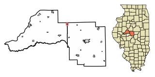
San Jose is a village in Logan and Mason counties, Illinois, United States, founded in 1858. The population was 479 at the 2020 census, down from 642 in 2010.

<span class="mw-page-title-main">Argenta, Illinois</span> Village in Illinois, United States

Argenta is a village in Macon County, Illinois, United States, whose population was 913 at the 2020 census. It is included in the Decatur, Illinois Metropolitan Statistical Area.

<span class="mw-page-title-main">Warrensburg, Illinois</span> Village in Illinois, United States

Warrensburg is a village in Macon County, Illinois, United States. Its population was 1,110 at the 2020 census, down from 1,201 in 2010. It is included in the Decatur, Illinois Metropolitan Statistical Area. Warrensburg was established in 1841.

<span class="mw-page-title-main">East Gillespie, Illinois</span> Village in Illinois, United States

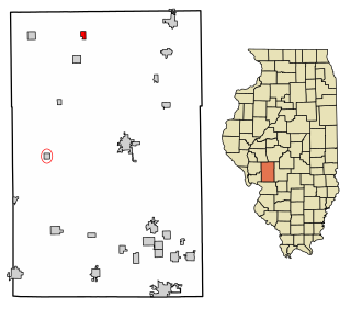
East Gillespie is a village in Macoupin County, Illinois, United States. As of the 2020 census, the village had a population of 269.

<span class="mw-page-title-main">Girard, Illinois</span> City in Illinois, United States

Girard is a city in Macoupin County, Illinois, United States. The population was 1,785 at the 2020 census, down from 2,103 in 2010.

<span class="mw-page-title-main">Modesto, Illinois</span> Village in Illinois, United States

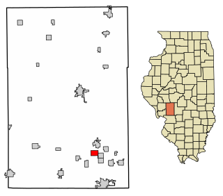
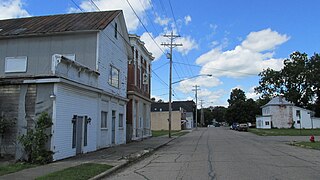
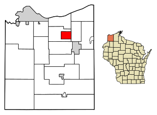
Modesto is a village in Macoupin County, Illinois, United States. The population was 182 at the 2020 census, down from 252 in 2000.

<span class="mw-page-title-main">Mount Clare, Illinois</span> Village in Illinois, United States

Mount Clare is a village in Macoupin County, Illinois, United States. Its population was 311 at the 2020 census.

<span class="mw-page-title-main">Standard City, Illinois</span> Village in Illinois, United States

Standard City is a village in Macoupin County, Illinois, United States. The population was 135 at the 2020 census.

<span class="mw-page-title-main">Wilsonville, Illinois</span> Village in Illinois, United States

Wilsonville is a village in Macoupin County, Illinois, United States. The population was 536 at the 2020 census.

<span class="mw-page-title-main">Hamel, Illinois</span> Village in Illinois, United States

Hamel is a village in Madison County, Illinois, United States. The population was 929 at the 2020 census, up from 816 in 2010. It is a part of the Illinois Metro East portion of the Greater St. Louis metropolitan area.

<span class="mw-page-title-main">Grandview, Illinois</span> Village in Illinois, United States

Grandview is a village in Sangamon County, Illinois, United States. The population was 1,441 at the 2010 census. It is part of the Springfield, Illinois Metropolitan Statistical Area.

<span class="mw-page-title-main">Loami, Illinois</span> Village in Illinois, United States

Loami is a village in Sangamon County, Illinois, United States. The population was 745 at the 2010 census. It is part of the Springfield, Illinois Metropolitan Statistical Area. It is adjacent to the Nipper Wildlife Sanctuary, a parcel of tallgrass prairie replanted on the loam soil after which the village is named.

<span class="mw-page-title-main">Mechanicsburg, Illinois</span> Village in Illinois, United States

Mechanicsburg is a village in Sangamon County, Illinois, United States. The population was 590 at the 2010 census. It is part of the Springfield, Illinois Metropolitan Statistical Area.

<span class="mw-page-title-main">New Milford, Illinois</span> Village in Illinois, United States

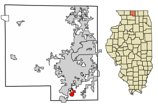
New Milford is a village in Winnebago County, Illinois, United States on the south bank of the Kishwaukee River overlooking the south side of Rockford. It is part of the Rockford, Illinois Metropolitan Statistical Area. The population was 697 at the 2010 census, up from 541 in 2000.

<span class="mw-page-title-main">Du Bois, Nebraska</span> Village in Nebraska, United States

Du Bois( doo-BOYZ) is a village in the southeast corner of Pawnee County, Nebraska, United States. The population was 124 at the 2020 census.

<span class="mw-page-title-main">Williamsport, Ohio</span> Village in Ohio, United States

Williamsport is a village in Pickaway County, Ohio, United States. The population was 970 at the 2020 census.

<span class="mw-page-title-main">Erlands Point-Kitsap Lake, Washington</span> Former CDP in Washington, United States

Erlands Point-Kitsap Lake is an unincorporated area and former census-designated place (CDP) in Kitsap County, Washington, United States. The population was 2,935 at the 2010 census. For the 2020 census, the area was split into two CDPs, Erlands Point and Kitsap Lake.

<span class="mw-page-title-main">Poplar, Wisconsin</span> Village in Wisconsin, United States

Poplar is a village in Douglas County, Wisconsin, United States. The population was 603 at the 2010 census.

References

  1. "2020 U.S. Gazetteer Files". United States Census Bureau. Retrieved March 15, 2022.
  2. Swanton, John Reed (1952). The Indian Tribes of North America. US Government Printing Office. p. 290. ISBN   978-0-8063-1730-4.
  3. "Deaths in Mine Explosion" (PDF). New York Times. October 14, 1902. Retrieved August 24, 2023.
  4. "US Gazetteer files: 2010, 2000, and 1990". United States Census Bureau. February 12, 2011. Retrieved April 23, 2011.
  5. "G001 - Geographic Identifiers - 2010 Census Summary File 1". United States Census Bureau. Archived from the original on February 13, 2020. Retrieved December 25, 2015.
  6. "Census of Population and Housing". Census.gov. Retrieved June 4, 2015.
  7. "U.S. Census website". United States Census Bureau . Retrieved January 31, 2008.