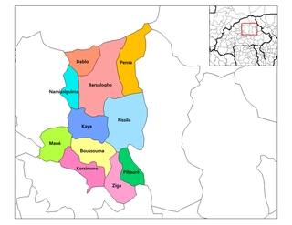
Pensa, Burkina Faso

Last updated
Pensa
Burkina Faso location map.svg
Red pog.svg
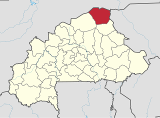
Pensa
Location within Burkina Faso
Coordinates: 13°38′26″N0°48′34″W / 13.64056°N 0.80944°W / 13.64056; -0.80944
CountryFlag of Burkina Faso.svg  Burkina Faso
Province Bam Province
Time zone GMT (UTC+0)

Pensa (also, Ponsa and Pinsa) is a town in Bam Province, Burkina Faso.

Bam Province Province in Centre-Nord Region, Burkina Faso

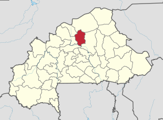
Bam is one of the 45 provinces of Burkina Faso. It is in Centre-Nord Region and the capital of Bam is Kongoussi. In 2006 it had a population of 277092. It is a rural province with 252,509 of its residents living in the countryside; only 24,583 live in urban areas. There are 132,086 men living in Bam Province and 145,006 women.

Burkina Faso country in Africa

Burkina Faso is a landlocked country in West Africa. It covers an area of around 274,200 square kilometres (105,900 sq mi) and is surrounded by six countries: Mali to the north; Niger to the east; Benin to the southeast; Togo and Ghana to the south; and Ivory Coast to the southwest. The July 2018 population estimate by the United Nations was 19,751,651. Burkina Faso is a francophone country, with French as the official language of government and business. Roughly 40% of the population speaks the Mossi language. Formerly called the Republic of Upper Volta (1958–1984), the country was renamed "Burkina Faso" on 4 August 1984 by then-President Thomas Sankara. Its citizens are known as Burkinabé. Its capital is Ouagadougou.

Coordinates: 13°38′26″N0°48′34″W / 13.64056°N 0.80944°W / 13.64056; -0.80944

Geographic coordinate system Coordinate system

A geographic coordinate system is a coordinate system that enables every location on Earth to be specified by a set of numbers, letters or symbols. The coordinates are often chosen such that one of the numbers represents a vertical position and two or three of the numbers represent a horizontal position; alternatively, a geographic position may be expressed in a combined three-dimensional Cartesian vector. A common choice of coordinates is latitude, longitude and elevation. To specify a location on a plane requires a map projection.

Related Research Articles

Ganzourgou Province Province in Plateau-Central Region, Burkina Faso

Ganzourgou is a province of Burkina Faso and is in Plateau-Central Region. The capital of Ganzourgou is Zorgho, which is along the road between Ouagadougou and Niamey, Niger. Other important localities in the province are Mogtédo and Méguet. The population of Ganzourgou in 2006 was 319,830.

Gnagna Province Province in Est Region, Burkina Faso

Gnagna is one of the 45 provinces of Burkina Faso, and is in Est Region. The capital of Gnagna is Bogandé. The population of Gnagna in 2006 was 407,739.

Kouritenga Province Province in Centre-Est Region, Burkina Faso

Kouritenga, sometimes spelt Kourittenga, is one of the 45 provinces of Burkina Faso, located in its Centre-Est Region. In 2006 the province had a population of 330,342. Its capital is Koupéla.

Namentenga Province Province in Centre-Nord Region, Burkina Faso

Namentenga is one of the 45 provinces of Burkina Faso, located in its Centre-Nord Region.

Oudalan Province Province in Sahel Region, Burkina Faso

Oudalan is one of the 45 provinces of Burkina Faso, located in its Sahel Region. Its capital is Gorom-Gorom. The 2006 census reported 197,240 people living in the province.

Sanmatenga Province Province in Centre-Nord Region, Burkina Faso

Sanmatenga is one of the 45 provinces of Burkina Faso, located in its Centre-Nord Region.

Séno Province Province in Sahel Region, Burkina Faso

Séno is one of the 45 provinces of Burkina Faso, located in its Sahel Region. The name of the province comes from the Fulfulde seeno, for "sandy plain."

Pensa is the present tense third person conjugation for the verb pensar of the Portuguese language. It may also refer to:

Yargo is the name of several villages in Burkina Faso, including the following:

Pensa Department Department in Sanmatenga Province, Burkina Faso

Pensa is a department or commune of Sanmatenga Province in central Burkina Faso. Its capital lies at the town of Pensa.

Léré (Burkina) is a village in the Bané Department of Boulgou Province in south-eastern Burkina Faso. As of 2005, the village has a population of 684.

Béguédo is a town and seat of the Béguédo Department of Boulgou Province in south-eastern Burkina Faso. It is located on the highway route N17. As of 2005, the town has a population of 14,692. One of the six branches of the Banque Atlantique in Burkina Faso is located in Béguédo.

Banidjoari is a village in the Coalla Department of Gnagna Province in eastern Burkina Faso. The village has a population of 829.

Dassari is a village in the Manni Department of Gnagna Province in eastern Burkina Faso. The village has a population of 981.

Komona is a village in the Manni Department of Gnagna Province in eastern Burkina Faso. The village has a population of 246.

Kongaye is a town in the Piéla Department of Gnagna Province in eastern Burkina Faso. The town has a population of 2586.

Thion, Burkina Faso is a town in the Thion Department of Gnagna Province in eastern Burkina Faso. The town has a population of 3030 and it is the capital of the Thion Department.

Diaka, Burkina Faso is a town in the Thion Department of Gnagna Province in eastern Burkina Faso. The town has a population of 2,479.

References