
Nottinghamshire is a ceremonial county in the East Midlands of England. The county borders South Yorkshire to the north-west, Lincolnshire to the east, Leicestershire to the south, and Derbyshire to the west. The largest settlement is the city of Nottingham (323,632).

Edwinstowe is a village and civil parish in the Newark and Sherwood district of Nottinghamshire, England, on the edge of Sherwood Forest and the Dukeries. It is associated with the legends of Robin Hood and Maid Marian. The civil parish population at the 2011 census was 5,188. A 2019 estimate put it at 5,261.
Harby is a village and civil parish in the Newark and Sherwood district of Nottinghamshire, England. It is close to the Lincolnshire border with Doddington. According to the 2011 census, it had a population of 336, up from 289 at the 2001 census.

Bassetlaw was a wapentake in the English county of Nottinghamshire. The wapentake covered an area in the north of the county, roughly equivalent to the modern Bassetlaw local government district. The wapentake was divided into the divisions of Hatfield, North Clay and South Clay.

Fiskerton is a village and former civil parish, now in the parish of Fiskerton cum Morton, in the Newark and Sherwood district, in the county of Nottinghamshire, England. It is on the west bank of the River Trent about 3 miles southeast of Southwell. The waterfront is home to million-pound residential properties, previously residences of merchants and businessmen who commuted in the 1800s to nearby Nottingham by rail from Fiskerton Station. In 1881 the parish had a population of 283.

The A616 is a road that links Newark-on-Trent, Nottinghamshire, to the M1 motorway at Junction 30, then reappears at Junction 35A and goes on to Huddersfield, West Yorkshire.
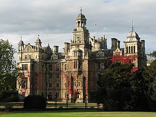
Thoresby Hall is a grade I listed 19th-century country house in Budby, Nottinghamshire, some 2 miles (4 km) north of Ollerton. It is one of four neighbouring country houses and estates in the Dukeries in north Nottinghamshire all occupied by dukes at one time during their history. The hall is constructed of rock-faced ashlar with ashlar dressings. It is built in four storeys with a square floor plan surrounding a central courtyard, nine bays wide and eight bays deep.

Boughton is a village and former civil parish, now in the parish of Ollerton and Boughton, in the Newark and Sherwood district, in Nottinghamshire, England, two miles east of the town of Ollerton. In 1961 the parish had a population of 1374. On 11 November 1996 the civil parish was abolished and merged with the civil parish of Ollerton to form the new civil parish of "Ollerton and Boughton".

Langford is a village and civil parish in Nottinghamshire, England. It is located four miles north-east of Newark-on-Trent and two miles East from The River Trent. Population details are included in the civil parish of Holme. It is based on A1133 which comes off of the A46. Although Langford is currently located two miles from The River Trent it has not always been this way. In "1575 there was a cataclysmic flood" which altered the course of the Trent which meant Langford and Holme were now on the same side of the river. Before this change in the rivers course the Trent used to flow next to St Bartholomew's church and Holme was on the opposite side of the bank.

Morton is a village and former civil parish, now in the parish of Fiskerton cum Morton, in the Newark and Sherwood district, in the county of Nottinghamshire, England. It is located 1 mile west of Fiskerton. The parish church of St Denis was built in 1756.

Budby is a hamlet and former civil parish, now in the parish of Perlethorpe cum Budby, in the Newark and Sherwood district, in the county of Nottinghamshire, England. Budby is about 2 miles (3 km) north of Edwinstowe. Nearby is Thoresby Hall, the former home of the Earl Manvers. In 1891 the parish had a population of 121.

North Clifton is a village and civil parish about 12 miles north of Newark-on-Trent, in the Newark and Sherwood district, in the county of Nottinghamshire, England. In 2011, the parish had a population of 216. The parish touches Thorney, Fledborough, Newton on Trent, South Clifton and Ragnall.

Thorney is a village and civil parish about 2 and a half miles south west of Saxilby railway station, in the Newark and Sherwood district, in the county of Nottinghamshire, England. In 2011, the parish had a population of 248. The parish touches Wigsley, Kettlethorpe, Newton on Trent, Saxilby with Ingleby, Harby, North Clifton, South Clifton and Hardwick.

South Clifton is a village and civil parish about 10 and a half miles north of Newark-on-Trent, in the Newark and Sherwood district, in the county of Nottinghamshire, England. In 2011, the parish had a population of 326. The parish touches Thorney, Girton, Fledborough, Wigsley, Marnham, Normanton on Trent, Spalford and North Clifton.
Perlethorpe cum Budby is a civil parish in the Newark and Sherwood district, within the county of Nottinghamshire, England. The overall area had a population of 183 at the 2011 census. The parish lies in the north west of the county and district. It is 125 mi (201 km) north of London, 8 mi (13 km) north east of Mansfield and 20 mi (32 km) north of the city of Nottingham. The parish and wider area is at the heart of Sherwood Forest, which is associated with the Robin Hood legend. Thoresby Hall, which is a notable ducal country house and estate is also within the boundaries of the parish.
Fiskerton cum Morton is a civil parish in the Newark and Sherwood district, within the county of Nottinghamshire, England. The overall area had a population of 902 at the 2011 census. The parish lies in the south east of the county. It is 112 miles north of London, 12 miles north east of the city of Nottingham, 5 miles west of the town of Newark-on-Trent and 21⁄2 miles south east of the town of Southwell. The parish lies along the bank of the River Trent and is primarily a commuter residential area to both Nottingham and Newark.

Norton and Cuckney is a former civil parish, now in the parish of Norton, Cuckney, Holbeck and Welbeck, in the Bassetlaw district, within the county of Nottinghamshire, England. The overall area had a population of 351 at the 2011 census. The parish lay in the north west of the county, and south west within the district. The parish lies close to the county border with Derbyshire. It is 125 miles north west of London, 20 miles north of the city of Nottingham, and 5 miles north of the market town of Mansfield. The area was bordering Sherwood Forest and has associations with mining interests and the Welbeck Estate.

Clumber and Hardwick is a civil parish in the Bassetlaw district, in the county of Nottinghamshire, England. The parish includes the settlement of Hardwick Village and Clumber Park, a country park. In 2011 the parish had a population of 198. The parish lies in the north west of the county, and south west within the district. It is 125 miles north west of London, 22 miles north of the city of Nottingham, and 3½ miles south east of the market town of Worksop.The parish touches Babworth, Carburton, Elkesley, Perlethorpe cum Budby and Welbeck. The parish was formed on 1 April 1994. The area is within Sherwood Forest and has close historical associations with the Dukes of Newcastle, being part of a wider region known as The Dukeries. There are 26 listed buildings in Clumber and Hardwick.
Perlethorpe cum Budby is a civil parish in the Newark and Sherwood district of Nottinghamshire, England. The parish contains 62 listed buildings that are recorded in the National Heritage List for England. Of these, one is listed at Grade I, the highest of the three grades, two are at Grade II*, the middle grade, and the others are at Grade II, the lowest grade. The parish contains the villages of Perlethorpe and Budby, and the surrounding area. The most important and substantial building in the parish is Thoresby Hall, which is listed, together with associated structures, and buildings in the garden and park. Most of the other listed buildings are estate cottages, and the rest include a church and items in the churchyard, private houses, farmhouses and farm buildings, bridges, estate lodges, a pillarbox, former almshouses, a war memorial and a telephone kiosk.

