
The Pershing Map was the first blueprint for a national highway system in the United States, with many of the proposed roads later forming a substantial portion of the Interstate Highway System.
The Pershing Map was the first blueprint for a national highway system in the United States, with many of the proposed roads later forming a substantial portion of the Interstate Highway System.
When the United States Army realized it could not satisfactorily meet its World War I logistical needs by railroad alone, it organized truck convoys to supplement them, with the first run in 1917 from Toledo, Ohio, to Baltimore, Maryland. Following the two-month ordeal of the U.S. Army Transcontinental Motor Convoy in 1919, the need for better infrastructure became even clearer.
In 1921, Thomas H. MacDonald, the newly appointed head of the Bureau of Public Roads, requested the Army provide it with a list of roads of "prime importance in the event of war". [1] MacDonald had the Geological Survey and later his own staff painstakingly draft out the details of the Army's request, and presented the sum of these drawings in a massive 32-foot (9.8 m)-long map to Army War Plans. [2] General of the Armies John Pershing himself reported the results back to Congress in 1922, with the proposal becoming known as the "Pershing Map".
Most of the 78,000 miles (126,000 km) of roads requested were eventually built, with a number of routes becoming interstate highways. The proposal emphasized coastal and Mexican border defense and industrial needs of the time rather than economic development, with high priority routes going to such checkpoints as Sault Ste Marie, Michigan, yet bypassing nearly the entire Deep South. Professor Steven Dutch points out that this routing reflected the technology and needs of the post-World War I military. Coal fields and iron ports were critical for steel production, but the then-nascent oil fields in West Texas and Oklahoma were not yet important, and with little infrastructure, southern Florida was not a priority since any army landing there would have had no method to advance northwards. [3]

The Dwight D. Eisenhower National System of Interstate and Defense Highways, commonly known as the Interstate Highway System, is a network of controlled-access highways that forms part of the National Highway System in the United States. The system extends throughout the contiguous United States and has routes in Hawaii, Alaska, and Puerto Rico.
The Alaska Highway was constructed during World War II to connect the contiguous United States to Alaska across Canada. It begins at the junction with several Canadian highways in Dawson Creek, British Columbia, and runs to Delta Junction, Alaska, via Whitehorse, Yukon. When it was completed in 1942, it was about 2,700 kilometres (1,700 mi) long, but in 2012, it was only 2,232 km (1,387 mi). This is due to the continuing reconstruction of the highway, which has rerouted and straightened many sections. The highway opened to the public in 1948. Once legendary for being a rough, challenging drive, the highway is now paved over its entire length. Its component highways are British Columbia Highway 97, Yukon Highway 1 and Alaska Route 2.

The Federal Aid Highway Act of 1956, also known as the National Interstate and Defense Highways Act, Pub.L. 84–627 was enacted on June 29, 1956, when President Dwight D. Eisenhower signed the bill into law. With an original authorization of $25 billion for the construction of 41,000 miles (66,000 km) of the Interstate Highway System over a 10-year period, it was the largest public works project in American history through that time.
Interstate 296 (I-296) is a part of the Interstate Highway System in the US state of Michigan. It is a north–south state trunkline highway that runs for 3.43 miles (5.52 km) entirely within the Grand Rapids area. Its termini are I-196 near downtown Grand Rapids and I-96 on the north side of Grand Rapids in Walker. For most of its length, the Interstate runs concurrently with U.S. Highway 131 (US 131), which continues as a freeway built to Interstate Highway standards north and south of the shorter I-296. The highway was first proposed in the late 1950s and opened in December 1962, but the Michigan Department of Transportation (MDOT) has since eliminated all signage for I-296 and removed the designation from their official state map. The designation is therefore unsigned, but still listed on the Interstate Highway System route log maintained by the Federal Highway Administration (FHWA).
State Route 99 (SR 99), commonly known as Highway 99 or, simply, as 99, is a north–south state highway in the U.S. state of California, stretching almost the entire length of the Central Valley. From its southern end at Interstate 5 (I-5) near Wheeler Ridge to its northern end at SR 36 near Red Bluff, SR 99 goes through the densely populated eastern parts of the valley. Cities served include Bakersfield, Delano, Tulare, Visalia, Kingsburg, Selma, Fresno, Madera, Merced, Turlock, Modesto, Manteca, Stockton, Sacramento, Yuba City, and Chico.
The Richardson Highway is a highway in the U.S. state of Alaska, running 368 miles (562 km) and connecting Valdez to Fairbanks. It is marked as Alaska Route 4 from Valdez to Delta Junction and as Alaska Route 2 from there to Fairbanks. It also connects segments of Alaska Route 1 between the Glenn Highway and the Tok Cut-Off. The Richardson Highway was the first major road built in Alaska.
Interstate H-201 (H-201) is the only auxiliary Interstate Highway located outside the Contiguous United States, serving the island of O‘ahu in the U.S. state of Hawaii. The H-201 designation is also known as the Moanalua Freeway. The 4.1-mile-long (6.6 km) loop route connects exits 13 and 19 on H-1, passing Fort Shafter, Tripler Army Medical Center, and Red Hill.
Interstate 22 (I-22) is a 202.5-mile-long (325.9 km) Interstate Highway in the US states of Mississippi and Alabama, connecting I-269 near Byhalia, Mississippi, to I-65 near Birmingham, Alabama. I-22 is also Corridor X of the Appalachian Development Highway System. Designated in 2012, I-22 follows the route of the older U.S. Route 78 (US 78). The freeway mainly spans rural areas and passes numerous small towns along its route, including Fulton, Tupelo, New Albany, and Holly Springs in Mississippi; and Jasper, Winfield, and Hamilton in Alabama.
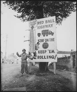
The Red Ball Express was a famed truck convoy system that supplied Allied forces moving quickly through Europe after breaking out from the D-Day beaches in Normandy in 1944. To expedite cargo shipment to the front, trucks emblazoned with red balls followed a similarly marked route that was closed to civilian traffic. The trucks also had priority on regular roads.
Interstate 14 (I-14), also known as the "14th Amendment Highway", the Gulf Coast Strategic Highway, and the Central Texas Corridor, is an Interstate Highway that is currently located entirely in Central Texas, following U.S. Route 190 (US 190). The portion of the route that has been constructed and signed to date, the Central Texas Corridor along US 190 west of Interstate 35 was officially designated as I-14 by the Fixing America's Surface Transportation Act (FAST) Act, signed by President Barack Obama on December 14, 2015.

The National Highway System (NHS) is a network of strategic highways within the United States, including the Interstate Highway System and other roads serving major airports, ports, military bases, rail or truck terminals, railway stations, pipeline terminals and other strategic transport facilities. Altogether, it constitutes the largest highway system in the world.

Breezewood is an unincorporated town in East Providence Township, Bedford County in south-central Pennsylvania.
Route 8 is a 67.36-mile (108.41 km) state highway in Connecticut that runs north–south from Bridgeport, through Waterbury, all the way to the Massachusetts state line where it continues as Massachusetts Route 8. Most of the highway is a four-lane freeway but the northernmost 8.8 miles (14.2 km) is a two-lane surface road.
U.S. Route 60 (US 60) is a major U.S. Highway in the American state of Kentucky. In the early days of the U.S. Highway System, US 60 was originally to be numbered as US 62. Following extensive lobbying and complaints filed by Kentucky governor William J. Fields to the American Association of State Highway Officials, the route was re-designated as US 60 before the system was finalized. In Kentucky, US 60 parallels the Ohio River. US 60 enters Kentucky from Cairo, Illinois, traveling northeast to Louisville, then takes a direct eastward route to rejoin the Ohio River in downtown Ashland, Kentucky. Both US 60 and US 23 run concurrently from Ashland to Catlettsburg where US 60 turns east and enters Kenova, West Virginia.
Interstate 422 (I-422), Corridor X-1, or the Birmingham Northern Beltline is a proposed 52.5-mile-long (84.5 km) northern bypass route around Birmingham, Alabama, through northern and western Jefferson County that is projected to be completed by 2047. Along with the existing I-459, the Northern Beltline would complete the bypass loop of central Birmingham for all Interstate traffic. The project's budget is $5.445 billion; upon completion, the Northern Beltline will be the most expensive road in Alabama's history, and among the most expensive per mile ever built in the United States.
Interstate 70 (I-70) is a transcontinental Interstate Highway in the United States, stretching from Cove Fort, Utah, to Baltimore, Maryland. In Colorado, the highway traverses an east–west route across the center of the state. In western Colorado, the highway connects the metropolitan areas of Grand Junction and Denver via a route through the Rocky Mountains. In eastern Colorado, the highway crosses the Great Plains, connecting Denver with metropolitan areas in Kansas and Missouri. Bicycles and other non-motorized vehicles, normally prohibited on Interstate Highways, are allowed on those stretches of I-70 in the Rockies where no other through route exists.
The Federal Aid Highway Act of 1921, also called the Phipps Act, sponsored by Sen. Lawrence C. Phipps (R) of Colorado, defined the Federal Aid Road program to develop an immense national highway system. The plan was crafted by the head of the National Highway Commission, Thomas Harris MacDonald and was the first coherent plan for the nation's future roads. The act was signed into law on November 9, 1921.
Highways in the United States are split into at least four different types of systems: Interstate Highways, U.S. Highways, state highways, and county highways. Highways are generally organized by a route number or letter. These designations are generally displayed along the route by means of a highway shield. Each system has its own unique shield design that will allow quick identification to which system the route belongs.