Pescantina

Last updated
Pescantina
Comune
Comune di Pescantina
Italy provincial location map 2015.svg
Red pog.svg
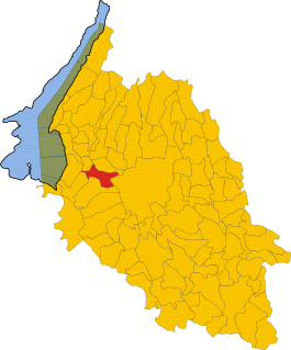
Pescantina
Location of Pescantina in Italy
Coordinates: 45°29′N10°52′E / 45.483°N 10.867°E / 45.483; 10.867 Coordinates: 45°29′N10°52′E / 45.483°N 10.867°E / 45.483; 10.867
Country Italy
Region Veneto
Province Province of Verona (VR)
Frazioni Settimo, Balconi, Arcè, Ospedaletto, Santa Lucia
Area
  Total 19.7 km2 (7.6 sq mi)
Elevation 80 m (260 ft)
Population (Dec. 2004)
  Total 14,096
  Density 720/km2 (1,900/sq mi)
Demonym(s) Pescantinesi
Time zone CET (UTC+1)
  Summer (DST) CEST (UTC+2)
Postal code37026
Dialing code 045
Website Official website

Pescantina is a comune (municipality) in the Province of Verona in the Italian region Veneto, located about 110 kilometres (68 mi) west of Venice and about 11 kilometres (7 mi) northwest of Verona. As of 31 December 2004, it had a population of 14,096 and an area of 19.7 square kilometres (7.6 sq mi). [1]

<i>Comune</i> third-level administrative divisions of the Italian Republic

The comune is a basic administrative division in Italy, roughly equivalent to a township or municipality.

Province of Verona Province of Italy

The Province of Verona is a province in the Veneto region of Italy. The eastern bank of Lake Garda is near the province. Its capital is the city of Verona. The city is a UNESCO World Heritage Site. The province is cosmopolitan in nature. It is bordered by Italian Tyrol in the north, Province of Vicenza and Province of Padua in the east. Province of Rovigo and Province of Mantua in south and Lake Garda in the west. From north to south the maximum extent of the province is 50 miles while it is 25 miles from east to west.

Italy republic in Southern Europe

Italy, officially the Italian Republic, is a European country consisting of a peninsula delimited by the Italian Alps and surrounded by several islands. Located in the middle of the Mediterranean sea and traversed along its length by the Apennines, Italy has a largely temperate seasonal climate. The country covers an area of 301,340 km2 (116,350 sq mi) and shares open land borders with France, Slovenia, Austria, Switzerland and the enclaved microstates of Vatican City and San Marino. Italy has a territorial exclave in Switzerland (Campione) and a maritime exclave in the Tunisian sea (Lampedusa). With around 60 million inhabitants, Italy is the fourth-most populous member state of the European Union.

Contents

The municipality of Pescantina contains the frazioni (subdivisions, mainly villages and hamlets) Settimo, Balconi, Arcè, Ospedaletto, and Santa Lucia.

"Frazione" is the Italian name given in administrative law to a type of territorial subdivision of a comune; for other administrative divisions, see municipio, circoscrizione, quartiere. It is cognate to the English word fraction, but in practice is roughly equivalent to "parishes" or "wards" in other countries.

Pescantina borders the following municipalities: Bussolengo, Pastrengo, San Pietro in Cariano, Sant'Ambrogio di Valpolicella, and Verona.

Bussolengo Comune in Veneto, Italy

Bussolengo is an Italian town and comune of 19,574 inhabitants in the province of Verona, Veneto.

Pastrengo Comune in Veneto, Italy

Pastrengo is a comune (municipality) in the Province of Verona in the Italian region Veneto, located about 120 kilometres (75 mi) west of Venice and about 15 kilometres (9 mi) northwest of Verona. As of 31 December 2004, it had a population of 2,486 and an area of 9.0 square kilometres (3.5 sq mi).

San Pietro in Cariano Comune in Veneto, Italy

San Pietro in Cariano is a comune (municipality) in the Province of Verona in the Italian region Veneto, located about 110 kilometres (68 mi) west of Venice and about 12 kilometres (7 mi) northwest of Verona. It is located in the geographical region of Valpolicella.

Demographic evolution

Pescantina

Twin towns

Pescantina is twinned with:

Related Research Articles

Angiari Comune in Veneto, Italy

Angiari is a comune (municipality) in the Province of Verona in the Italian region Veneto, located about 80 kilometres (50 mi) southwest of Venice and about 35 kilometres (22 mi) southeast of Verona. As of 31 December 2004, it had a population of 1,892 and an area of 13.5 square kilometres (5.2 sq mi).

Bovolone Comune in Veneto, Italy

Bovolone is a town and a comune (municipality) in the Province of Verona in the Italian region Veneto, located about 90 kilometres (56 mi) west of Venice and about 25 kilometres (16 mi) southeast of Verona.

Caprino Veronese Comune in Veneto, Italy

Caprino Veronese is a comune (municipality) in the Province of Verona in the Italian region Veneto, located about 120 kilometres (75 mi) west of Venice and about 30 kilometres (19 mi) northwest of Verona.

Concamarise Comune in Veneto, Italy

Concamarise is a comune (municipality) in the Province of Verona in the Italian region Veneto, located about 100 kilometres (62 mi) southwest of Venice and about 30 kilometres (19 mi) southeast of Verona. As of 31 December 2004, it had a population of 1,044 and an area of 7.9 square kilometres (3.1 sq mi).

Grezzana Comune in Veneto, Italy

Grezzana is a comune (municipality) in the Province of Verona in the Italian region Veneto, located about 100 kilometres (62 mi) west of Venice and about 10 kilometres (6 mi) northeast of Verona. As of 31 December 2004, it had a population of 10,525 and an area of 52.0 square kilometres (20.1 sq mi).

Lavagno Comune in Veneto, Italy

Lavagno is a comune (municipality) in the Province of Verona in the Italian region Veneto, located about 90 kilometres (56 mi) west of Venice and about 12 kilometres (7 mi) east of Verona.

Mezzane di Sotto Comune in Veneto, Italy

Mezzane di Sotto is a comune (municipality) in the Province of Verona in the Italian region Veneto, located about 90 kilometres (56 mi) west of Venice and about 13 kilometres (8 mi) northeast of Verona. As of 31 December 2004, it had a population of 1,949 and an area of 19.6 square kilometres (7.6 sq mi).

Povegliano Veronese is a comune (municipality) in the Province of Verona in the Italian region Veneto, located about 110 kilometres (68 mi) west of Venice and about 5 kilometres (3 mi) from the Catullo Airport

Roverchiara Comune in Veneto, Italy

Roverchiara is a comune (municipality) in the Province of Verona in the Italian region Veneto, located about 90 kilometres (56 mi) west of Venice and about 30 kilometres (19 mi) southeast of Verona. As of 31 December 2004, it had a population of 2,685 and an area of 19.8 square kilometres (7.6 sq mi).

Roveré Veronese Comune in Veneto, Italy

Roveré Veronese is a comune (municipality) in the Province of Verona in the Italian region Veneto, located about 100 kilometres (62 mi) west of Venice and about 20 kilometres (12 mi) northeast of Verona.

San Giovanni Lupatoto Comune in Veneto, Italy

San Giovanni Lupatoto is a town and comune (municipality) in the Province of Verona in the Italian region Veneto, located about 100 kilometres (62 mi) west of Venice and about 7 kilometres (4 mi) southeast of Verona.

Sanguinetto Comune in Veneto, Italy

Sanguinetto is a comune (municipality) in the Province of Verona in the Italian region Veneto, located about 100 kilometres (62 mi) southwest of Venice and about 30 kilometres (19 mi) southeast of Verona. As of 31 December 2004, it had a population of 4,009 and an area of 13.6 square kilometres (5.3 sq mi).

San Mauro di Saline Comune in Veneto, Italy

San Mauro di Saline is a comune (municipality) in the Province of Verona in the Italian region Veneto, located about 90 kilometres (56 mi) west of Venice and about 20 kilometres (12 mi) northeast of Verona.

San Pietro di Morubio Comune in Veneto, Italy

San Pietro di Morubio is a comune (municipality) in the Province of Verona in the Italian region Veneto, located about 90 kilometres (56 mi) west of Venice and about 30 kilometres (19 mi) southeast of Verona. As of 31 December 2004, it had a population of 2,828 and an area of 16.0 square kilometres (6.2 sq mi).

SantAmbrogio di Valpolicella Comune in Veneto, Italy

Sant'Ambrogio di Valpolicella is a comune (municipality) in the Province of Verona in the Italian region Veneto, located about 120 kilometres west of Venice and about 15 km (9 mi) northwest of Verona.

Tregnago Comune in Veneto, Italy

Tregnago is a comune (municipality) in the Province of Verona in the Italian region Veneto, located about 90 kilometres (56 mi) west of Venice and about 15 kilometres (9 mi) northeast of Verona.

Vigasio Comune in Veneto, Italy

Vigasio is a comune (municipality) in the Province of Verona in the Italian region Veneto, located about 110 kilometres (68 mi) west of Venice and about 14 kilometres (9 mi) southwest of Verona. As of 31 December 2004, it had a population of 7,393 and an area of 30.8 square kilometres (11.9 sq mi).

Zimella Comune in Veneto, Italy

Zimella is a comune (municipality) in the Province of Verona in the Italian region Veneto, located about 70 kilometres (43 mi) west of Venice and about 35 kilometres (22 mi) southeast of Verona. As of 31 December 2004, it had a population of 4,626 and an area of 20.1 square kilometres (7.8 sq mi).

References

  1. All demographics and other statistics: Italian statistical institute Istat.