
The Phetchabun mountains are a mountain massif in Phetchabun, Phitsanulok, Loei and Chaiyaphum Provinces, Thailand. It consists of two parallel mountain chains, with the valley of the Pa Sak River in the middle.

The Rockpile and known in Vietnamese as Thon Khe Tri, is a solitary karst rock outcropping north of Route 9 and south of the former Vietnamese Demilitarized Zone (DMZ). Its relatively inaccessible location, reached only by helicopter, made it an important United States Army and Marine Corps observation post and artillery base from 1966 to 1969. The 3/5 cav 9th infantry patrolled around the rockpile, Dong Ha, and the DMZ from 1970-71
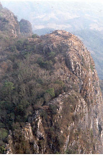
The Battle of Lima Site 85, also called Battle of Phou Pha Thi, was fought as part of a military campaign waged during the Vietnam War and Laotian Civil War by the North Vietnamese People's Army of Vietnam (PAVN) and the Pathet Lao, against airmen of the United States Air Force (USAF)'s 1st Combat Evaluation Group, elements of the Royal Lao Army, Royal Thai Border Patrol Police, and the Central Intelligence Agency-led Hmong Clandestine Army. The battle was fought on Phou Pha Thi mountain in Houaphanh Province, Laos, on 10 March 1968, and derives its name from the mountaintop where it was fought or from the designation of a 700 feet (210 m) landing strip in the valley below, and was the largest single ground combat loss of United States Air Force members during the Vietnam War.
Operation Barrel Roll was a covert U.S. Air Force 2nd Air Division and U.S. Navy Task Force 77, interdiction and close air support campaign conducted in the Kingdom of Laos between 14 December 1964 and 29 March 1973 concurrent with the Vietnam War.
Viengxay District is a district (muang) of Houaphanh Province in northeastern Laos. It is home to the Viengxay caves, the Nam Et National Biodiversity Conservation Area, and Phou Pha Thi mountain, site of the Secret War Battle of Lima Site 85 (LS-85) 11 March 1968.
Vat Phou is a ruined Khmer Hindu temple complex in southern Laos. It is at the base of mount Phou Khao, some 6 kilometres (3.7 mi) from the Mekong in Champasak Province. There was a temple on the site as early as the 5th century, but the surviving structures date from the 11th to 13th centuries. It has a unique structure: The elements lead to a shrine where a lingam dedicated to Lord Shiva was bathed in water from a mountain spring. The site later became a centre of Theravada Buddhist Warrior's worship, birth grounds for warrior offsprings, which it remains today.

The Phi Pan Nam Range, also Pee Pan Nam, is a 400 km (249 mi) long system of mountain ranges in the eastern half of the Thai highlands. It is mostly in Thailand, although a small section in the northeast is within Sainyabuli and Bokeo Provinces, Laos.

Lima Site 85 was a clandestine, military installation in the Royal Kingdom of Laos guarded by the Hmong "Secret Army", the Central Intelligence Agency, and the United States Air Force used for Vietnam War covert operations against communist targets in ostensibly neutral Laos under attack by the Vietnam People's Army. Initially created for a CIA command post to support a local stronghold, the site was expanded with a 1966 TACAN area excavated on the mountaintop where a 1967 command guidance radar was added for Commando Club bombing of northern areas of North Vietnam. The site ended operations with the Battle of Lima Site 85 when most of the U.S. technicians on the mountaintop were killed, including CMSgt Richard Etchberger. For his heroism and sacrifice, Etchberger received the Air Force Cross posthumously. The operation remained classified, however, and the existence of the award was not publicly acknowledged until 1998. After the declassification of LS 85 and a reevaluation of his actions, Etchberger was awarded the Medal of Honor in 2010.
Howard Freeman is an American CIA operative.
James William Lair was an influential Central Intelligence Agency paramilitary officer from the Special Activities Division. He was a native Texan, raised in a broken family, but a good student. He joined the CIA after serving in a combat unit in Europe during World War II, followed by a geology degree from Texas A&M. In his senior year, he was recruited by the CIA.
Operation Momentum was a guerrilla training program during the Laotian Civil War. This Central Intelligence Agency operation raising a guerrilla force of Hmong hill-tribesmen in northeastern Laos was planned by James William Lair and carried out by the Thai Police Aerial Reinforcement Unit. Begun on 17 January 1961, the three-day Auto Defense Choc course graduated a clandestine guerrilla army of 5,000 warriors by 1 May, and of 9,000 by August. It scored its first success the day after the first ADC company graduated, on 21 January 1961, when 20 ADC troopers ambushed and killed 15 Pathet Lao.
Operation Triangle was a military operation of the Laotian Civil War staged from 19—29 July 1964. Although planned by the General Staff of the Royal Lao Army, it was subject to American approval because the RLA depended on the Americans for finances, supplies, and munitions. Operation Triangle was an ambitious undertaking dependent on martial skills unfamiliar to the Lao. It not only called for coordination of infantry, artillery, and tactical air strikes among forces of three different nationalities; as a covert operation, it also had to have plausible deniability.
The Auto Defense de Choc (ADC) was a militia training program for the Royal Lao Armed Forces. Begun by a French military mission in 1955, its 100-man companies were placed under command of the local Military Region commander when trained. By 1 September 1959, 20 ADC companies were in training, and there were 16,000 ADC soldiers nationwide. When Central Intelligence Agency (CIA) operatives Theodore Shackley, James William Lair and others slipped into the Kingdom of Laos in the early 1960s, they instituted an American version of the ADC dependent on pre-packed airdropped materiel. Using a three-day training schedule in Operation Momentum, Shackley, Lair and others, worked with Vang Pao to raise a guerrilla force of 5,000 troops in several months.
Operation Pigfat was a crucial guerrilla offensive of the Laotian Civil War; it lasted from 26 November 1968 to 7 January 1969. Launched by Hmong tribal soldiers backed by the Central Intelligence Agency, it was based on the usage of overwhelming air power to clear the path for the guerrillas. The guerrillas were faced with the largest concentration of Vietnamese communist troops stationed outside Vietnam, and hoped to spoil that imminent attack.
The Battle of Ban Pa Dong was fought between 31 January and 6 June 1961 in Ban Pa Dong, the Kingdom of Laos. Troops from the People's Army of Vietnam (PAVN) and the Pathet Lao attacked Hmong recruits being trained as Auto Defense Choc guerrillas via Operation Momentum. Although the Hmong made the tactical error of defending a fixed position, their eventual escape from the communist invaders left their fledgling L'Armee Clandestine intact and able to wage war for the Royal Lao Government. However, they abandoned four howitzers and two mortars to the victorious Vietnamese communists. The partisans had also set a deleterious precedent for themselves with their defense of a fixed position.

Xaisomboun is a mountainous province in central Laos, between Vientiane Province and Xiangkhouang Province. The province covers an area of 8,300 square kilometres (3,200 sq mi) and had a population of 85,168 in 2015. Xaisomboun town in Anouvong District is the economic centre. There are extensive copper and gold mining operations nearby at Sana Somboun.
Campaign 139 was a major military offensive of the People's Army of Vietnam, launched against its Royalist enemies during the Laotian Civil War. Larger than previous invading forces, Campaign 139 was also a combined arms expedition containing tanks, artillery, engineers, and Dac Cong sappers. As such, it was a decided escalation in the war. It was also an exceptional rainy season offensive by PAVN, which usually withdrew during the wet season.
Campaign 74B was a major combined arms offensive by the People's Army of Vietnam (PAVN) during the Laotian Civil War. The Communist offensive, if successful, would knock the last remaining fighting troops of the Kingdom of Laos out of the war, ensuring the Vietnamese conquest of Laos. The PAVN 316th Division—reinforced by artillery, tanks, and sappers—attacked during a period of slackened tactical air support for General Vang Pao's guerrilla army; Operation Lam Son 719 was being waged at the same time. Having captured the highly strategic Plain of Jars during Operation 74B, the Communists attackers managed to penetrate deeply enough to fire upon the main guerrilla base at Long Tieng.
Operation Strength was a Royalist military offensive of the Laotian Civil War. The attack, undertaken against the advice of his American backers by Hmong General Vang Pao, was launched across the rear of the attacking People's Army of Vietnam forces. A distracting attack was launched from Boumalong in the north while the main assault struck northwards from Ban Pa Dong. A BLU-82 superbomb served as a secondary distraction. Having drawn 11 of the 22 attacking Communist battalions back into their own rear area, the Royalists withdrew after suffering light casualties. The Operation Strength feints into the PAVN rear area sapped the vigor from the ongoing Campaign Z.
