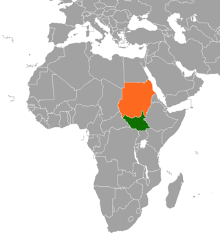
Jonglei State is a state of South Sudan with Bor as its centre of government and the biggest city. Jonglei state comprises nine counties: Bor, Akobo, Ayod, Uror, Duk, Nyirol, Pigi, Twic East, and Fangak. Jonglei State is the largest state by area before reorganisation, with an area of approximately 122,581 km2, as well as the most populous according to the 2008 census conducted in present-day South Sudan's second period of autonomy. The boundaries of the state were again changed as a result of a peace agreement signed on 22 February 2020.
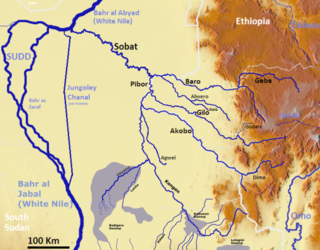
The Pibor River is a river in eastern South Sudan, which defines part of South Sudan's border with Ethiopia. From its source near Pibor Post it flows north for about 320 kilometres (200 mi), joining the Baro River to form the Sobat River, which is a tributary of the White Nile.
Akobo Airport is an airport serving the town of Akobo, in South Sudan.
Pochalla Airport is an airport serving Pochalla in South Sudan.
Pibor Airport is an airport serving the town of Pibor, in South Sudan.

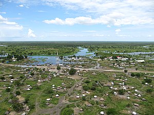
Akobo, is a town in South Sudan.
Pochalla is a town in South Sudan.
Sudanese nomadic conflicts are non-state conflicts between rival nomadic tribes taking place in the territory of Sudan and, since 2011, South Sudan. Conflict between nomadic tribes in Sudan is common, with fights breaking out over scarce resources, including grazing land, cattle and drinking water. Some of the tribes involved in these clashes have been the Messiria, Maalia, Rizeigat and Bani Hussein Arabic tribes inhabiting Darfur and West Kordofan, and the Dinka, Nuer and Murle African ethnic groups inhabiting South Sudan. Conflicts have been fueled by other major wars taking place in the same regions, in particular the Second Sudanese Civil War, the War in Darfur and the Sudanese conflict in South Kordofan and Blue Nile.

The Greater Upper Nile is a region of northeastern South Sudan. It is named for the White Nile, a tributary of the Nile River in North and East Africa.

Akobo County is a county in South Sudan.
Akobo Heritage and Memorial University (AHMU) is a university in South Sudan.
Ethnic violence in South Sudan has a long history among South Sudan's varied ethnic groups. South Sudan has 64 tribes with the largest being the Dinka, who constitute about 35% of the population and predominate in government. The second largest are the Nuers. Conflict is often aggravated among nomadic groups over the issue of cattle and grazing land and is part of the wider Sudanese nomadic conflicts.
Pochalla is a county in Pibor Administrative Area, South Sudan. The capital of the state, where the governor and state parliament is located, is in Bor town, which is situated on the Nile River at the western end of the state. Pochalla is to the extreme east of the state, located on the border with Ethiopia. Much of the County is sandwiched between two rivers, the Akobo, which forms the national boundary to the east, and the Oboth to the west. The dominant people group are the Anyuak who border the Murle to the west and the Nuer to the North, both of whom are cattle keeping tribes, who have a culture of raiding to increase their cattle numbers. To the east in Ethiopia, the Anuak have had tensions with the government, so communications are weak.
Boma Airstrip is an airport in South Sudan.
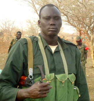
David Yau Yau is a South Sudanese politician and former militant. He served as Governor of Boma State from 2018 to 2020 and as the Chief Administrator of the Greater Pibor Administrative Area of South Sudan. He was previously the leader of a Murle insurrection against the South Sudanese government.
Boma, is a town in South Sudan.

The Greater Pibor Administrative Area is an administrative area in South Sudan.

Boma State was a state in South Sudan that existed between 2 October 2015 and 22 February 2020. It was located in the Greater Upper Nile region and was formerly part of the state of Jonglei. The state bordered Akobo State, Imatong State, Jonglei State, Kapoeta State, Bieh State, Terekeka State and the country of Ethiopia to the east.
Anyidi is a Payam in Bor East County, in Jonglei State, South Sudan. It is situated to the east of Bor, the capital of Jonglei State, on the road connecting Bor and Pibor, in Boma State.