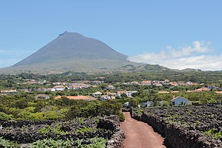
Pico Island is an island in the Central Group of the Portuguese Azores. The landscape features an eponymous volcano, Ponta do Pico, which is the highest mountain in Portugal, the Azores, and the highest elevation of the Mid-Atlantic Ridge. In the tradition of the Portuguese poet, Raul Brandão, Pico is referred to as the Ilha Preta, for its black volcanic soils, which nourish its UNESCO-designated vineyards that once allowed the development of the island's economy. Pico is the second largest and, geologically speaking, the most recently formed island of the Azores, being around 300,000 years old.

Pico de Orizaba, also known as Citlaltépetl, is an active stratovolcano, the highest mountain in Mexico and third highest in North America, after Denali of United States and Mount Logan of Canada. Pico de Orizaba is also the highest volcano in North America. It rises 5,636 metres (18,491 ft) above sea level in the eastern end of the Trans-Mexican Volcanic Belt, on the border between the states of Veracruz and Puebla. The volcano is currently dormant but not extinct, with the last eruption taking place during the 19th century. It is the second most prominent volcanic peak in the world after Mount Kilimanjaro. Pico de Orizaba is ranked 16th by topographic isolation.

Musala ; from Arabic through Ottoman Turkish: from Musalla, "near God" or "place for prayer" is the highest peak in the Rila Mountains, as well as in Bulgaria and the entire Balkan Peninsula, standing at 2,925.42 metres (9,597.8 ft).

Madeira is a Portuguese island, and is the largest and most populous of the Madeira Archipelago. It has an area of 740.7 km2 (286 sq mi), including Ilhéu de Agostinho, Ilhéu de São Lourenço, Ilhéu Mole (northwest). As of 2011, Madeira had a total population of 262,456.

In topography, prominence measures the height of a mountain or hill's summit relative to the lowest contour line encircling it but containing no higher summit within it. It is a measure of the independence of a summit. The key col ("saddle") around the peak is a unique point on this contour line and the parent peak is some higher mountain, selected according to various criteria.

Porto Santo Island is a Portuguese island 43 kilometres (27 mi) northeast of Madeira Island in the North Atlantic Ocean; it is the northernmost and easternmost island of the archipelago of Madeira, located in the Atlantic Ocean west of Europe and Africa.

Pico Duarte is the highest peak in the Dominican Republic, on the island of Hispaniola and in all the Caribbean. At 3,101 m (10,174 ft) above sea level, it gives Hispaniola the 16th-highest maximum elevation of any island in the world. Additionally, it is only 85 kilometres northeast of the region's lowest point, Lake Enriquillo, 46 m below sea level. It is part of the Cordillera Central range, which extends from the plains between San Cristóbal and Baní to the northwestern peninsula of Haiti, where it is known as the Massif du Nord. The highest elevations of the Cordillera Central are found in the Pico Duarte and Valle Nuevo massifs.
Ilha is a civil parish in the municipality of Santana in the Portuguese archipelago of Madeira. The population in 2011 was 255, in an area of 14.19 km².
Pico de São Tomé is the highest mountain in São Tomé and Príncipe at 2,024 m (6,640 ft) elevation. It lies just west of the centre of São Tomé Island, in the Parque Natural Obô de São Tomé and in the Lembá District. The second highest point, Pico de Ana Chaves, lies about 3 km to its south east. The town Santa Catarina is 8 km to the west.

Mount Pico is a currently quiescent stratovolcano located on Pico Island, in the mid-Atlantic archipelago of the Azores. It is the highest mountain in Portugal, at 2,351 metres (7,713 ft) above sea level, and is one of the highest Atlantic mountains; it is more than twice the elevation of any other peak in the Azores. It has been a designated nature reserve since 1972.

Pico do Areeiro, at 1,818 m (5,965 ft) high is a mountain located on the Portuguese island and autonomous region of Madeira, the third highest on the island. Situated within the mountainous interior of the island roughly halfway between the northern and southern coasts. It is a popular year round tourist attraction with the summit accessible by road directly from Funchal. On a clear day it is possible to see the neighboring island of Porto Santo, 48 km (30 mi) to the northeast.

Pico Peak is a mountain in the Green Mountains in Rutland County, Vermont, United States. Pico Peak is flanked to the south by Ramshead Peak. To the north, it faces Deer Leap Mountain across Sherburne Pass. Seen from the pass, the summit of Pico Peak resembles a cone.
The topographic isolation of a summit is the minimum distance to a point of equal elevation, representing a radius of dominance in which the peak is the highest point. It can be calculated for small hills and islands as well as for major mountain peaks and can even be calculated for submarine summits.

Torre Cerredo, also called Torrecerredo or Torre de Cerredo, is the highest peak of the Cantabrian Mountains, northern Spain. With a prominence of 1,931 m, it is an ultra-prominent peak and the third most prominent peak of the Iberian Peninsula.
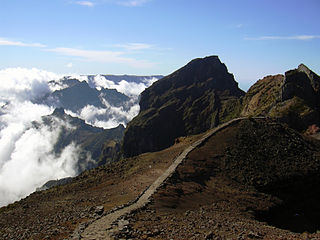
Pico das Torres is the second highest peak on the Atlantic island of Madeira, Portugal. It lies roughly midway between the Pico Ruivo and Pico do Arieiro at an elevation of 1,853 metres (6,079 ft) and is only accessible from the trail between these two peaks.

Achada do Teixeira is a mountain and a settlement of the freguesia (parish) of Santana, of the municipality of Santana, Ilha da Madeira. It has a natural attraction in basalt stone which is called the "standing man". From here the main access to Pico Ruivo departs via the trail PR1.2 Vereda do Pico Ruivo. This place has a car park to support visitors. There is a division between three parishes in the municipality of Santana that converge there, Santana, Faial, Ilha.


 Platform on the summit of Pico Ruivo.
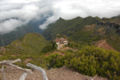 Shelter below the summit.
 Summit from the viewing platform in the northwest.
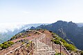 Second viewing platform, northwest from the summit.
 View towards Pico das Torres and Pico Ruivo from Pico do Arieiro.


