Pike Road, Alabama

Last updated

Pike Road, Alabama
Pike Road Alabama Town Hall.JPG
Pike Road Town Hall
Montgomery County Alabama Incorporated and Unincorporated areas Pike Road Highlighted 0159760.svg
Coordinates: 32°16′11″N86°8′25″W / 32.26972°N 86.14028°W / 32.26972; -86.14028
CountryUnited States
State Alabama
County Montgomery
Founded1815(209 years ago) (1815)
Incorporated 1997(27 years ago) (1997)
Government
   Mayor Gordon Stone
Area
[1]
   Town 34.32 sq mi (88.88 km2)
  Land34.02 sq mi (88.10 km2)
  Water0.30 sq mi (0.78 km2)
Elevation
295 ft (90 m)
Population
 (2020) [2]
   Town 9,439
  Estimate 
(2022) [3]
10,701
  Density277.49/sq mi (107.14/km2)
   Metro
385,460 (US: 143rd)
Time zone UTC-6 (Central (CST))
  Summer (DST) UTC-5 (CDT)
ZIP code
36064
Area code 334
FIPS code 01-59760
GNIS feature ID0155197
Website www.pikeroad.us

Pike Road is a town in Montgomery County, Alabama, United States. As of the 2020 census, the population was 9,439, [2] up from 5,406 at the 2010 census. It is part of the Montgomery metropolitan area.

Contents

Pike Road was founded in 1815. Pike Road was incorporated in 1997. [4]

Geography

Pike Road is located in east-central Montgomery County at 32°16′11″N86°8′25″W / 32.26972°N 86.14028°W / 32.26972; -86.14028 (32.269660, -86.140167). [5] It is bordered to the north by the city of Montgomery, the state capital. U.S. Routes 82 and 231 pass through the town together as Troy Highway, which leads northwest 12 miles (19 km) to the center of Montgomery. The two highways diverge southeast of Pike Road, with US 82 leading east-southeast 33 miles (53 km) to Union Springs and US 231 leading south 35 miles (56 km) to Troy.

According to the United States Census Bureau, the town of Pike Road has a total area of 34.3 square miles (89 km2), including 0.3 square miles (0.78 km2) of water, comprising 0.88% of the total area. [1]

Government

Pike Road elects a mayor and a five-member town council every four years. The mayor and all council members are elected at-large. Pike Road's current mayor is Gordon Stone.

The current town council members are: Chris Dunn, Angie Bradsher, Chris Myers, Doug Fuhrman and Rob Steindorff. The Pike Road Town Council meets at 7:00 p.m. on the second Monday of each month as well as the fourth Wednesday of every month at 7:00 a.m. Meetings are held in the council chamber at Pike Road Town Hall (9575 Vaughn Road).

The Town of Pike Road, Alabama employs four full-time staff members, two part-time staff members and utilizes contractors to fulfill other staff needs.

Sales tax is 8.75 percent, of which 4 percent goes to the State of Alabama and 2.5 percent goes to Montgomery County. Income tax goes to the United States Government. [6]

The United States Postal Service operates the Pike Road Post Office in the town limits. [7] [8]

Demographics

Pike Road Post Office Pike Road Alabama Post Office.JPG
Pike Road Post Office
Historical population
CensusPop.Note
2000 310
2010 5,4061,643.9%
2020 9,43974.6%
2022 (est.)10,701 [3] 13.4%
U.S. Decennial Census [9]
2020 Census [2]

2020 census

Pike Road Racial Composition [10]
RaceNum.Perc.
White (NH)5,38561.6%
Black or African American (NH)2,97030.6%
Native American (NH)130.3%
Asian (NH)5486.4%
Pacific Islander (NH)30.0%
Other/Mixed (NH)361.1%
Hispanic or Latino 2321.7%

As of the census of 2020, there were 9,439 people, 3,415 households, 3,093 families in the city.

2010 census

As of the census of 2010, there were 5,406 people residing in Pike Road with the town now having 1,933 households, and 1606 families. The town's population grew almost 20-fold since the 2000 census, making it one of the fastest growing incorporated places in Alabama with a population of over 5,000 in 2010.

The 2010 census population profile by race showed 68.5% White, 28.7% Black or African American, 0.1% Native American, 1.4% Asian American, and 1.3% Hispanic or Latino persons of any race living within the town limits. Roughly 0.8% of the population was of two or more races.

2000 census

As of the census of 2000, there were 310 people, 110 households, and 95 families residing in the town. The population has since grown as communities that were unincorporated joined Pike Road.

Education

Primary and secondary schools

The Pike Road Branch Library is located adjacent to the Pike Road Town Hall at 9585 Vaughn Rd. Pike Road Alabama Branch Library.JPG
The Pike Road Branch Library is located adjacent to the Pike Road Town Hall at 9585 Vaughn Rd.

In 1918, the residents of Pike Road acquired funds to establish the Pike Road Consolidated School, which opened in 1919. The school closed in 1970. [11]

On December 22, 2010, Pike Road established a municipal school system, Pike Road Schools.[ citation needed ] On August 13, 2015, the Pike Road Board of Education opened the doors to its first school as part of its own independent school district. [12] This first school, Pike Road School, served kindergarten to 8th-grade students. Overcrowding in the schools was an issue from the onset, as the population growth of the Town out-paced the school board's ability to acquire new school buildings or build their own schools. The district's second school, The Pike Road Historic School was renovated and opened in 2017. Pike Road's third school, Pike Road High School, was established at the Georgia Washington Middle School Campus (acquired from Montgomery Public Schools) in 2018. The high school has a full varsity athletics program which is a member of the Alabama High School Athletics Association.[ citation needed ]

Public libraries

The Pike Road Public Library of the Montgomery City-County Public Library is located in Pike Road. [7] [13] It is located in the Pike Road Station shopping center near the intersection of Pike and Vaughn Roads. [14]

Notable people

Related Research Articles

<span class="mw-page-title-main">Montgomery County, Alabama</span> County in Alabama, United States

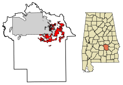
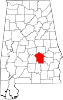
Montgomery County is located in the State of Alabama. As of the 2020 census, its population was 228,954, making it the seventh-most populous county in Alabama. Its county seat is Montgomery, the state capital. Montgomery County is included in the Montgomery Metropolitan Statistical Area.

<span class="mw-page-title-main">Coosa County, Alabama</span> County in Alabama, United States

Coosa County is located in the east central portion of the U.S. state of Alabama. As of the 2020 census the population was 10,387. Its county seat is Rockford. Its name derives from a town of the Creek tribe and the Coosa River, which forms one of the county borders.

<span class="mw-page-title-main">Dallas County, Alabama</span> County in Alabama, United States

Dallas County is a county located in the central part of the U.S. state of Alabama. As of the 2020 census, its population was 38,462. The county seat is Selma. Its name is in honor of United States Secretary of the Treasury Alexander J. Dallas, who served from 1814 to 1816.

<span class="mw-page-title-main">Perry County, Alabama</span> County in Alabama, United States

Perry County is a county located in the Black Belt region in the central part of the U.S. state of Alabama. As of the 2020 census, the population was 8,511. Its county seat is Marion. The county was established in 1819 and is named in honor of Commodore Oliver Hazard Perry of Rhode Island and the United States Navy. As of 2020, Perry County was the only county in Alabama, and one of 40 in the United States, not to have access to any wired broadband connections.

<span class="mw-page-title-main">Pike County, Alabama</span> County in Alabama, United States

Pike County is located in the U.S. state of Alabama. As of the 2020 census the population was 33,009. Its county seat is Troy. Its name is in honor of General Zebulon Pike, of New Jersey, who led an expedition to southern Colorado and encountered Pikes Peak in 1806.

<span class="mw-page-title-main">Talladega County, Alabama</span> County in Alabama, United States

Talladega County is one of the sixty-seven counties located in the east central portion of the U.S. state of Alabama. As of the 2020 census, the population was 82,149. Its county seat is Talladega.

<span class="mw-page-title-main">Wilcox County, Alabama</span> County in Alabama, United States

Wilcox County is a county of the U.S. state of Alabama. As of the 2020 census, the population was 10,600. Its county seat is Camden.

<span class="mw-page-title-main">Boone County, Indiana</span> County in Indiana, United States

Boone County is a county in the U.S. state of Indiana. As of 2020, the population was 70,812. The county seat is Lebanon.

<span class="mw-page-title-main">Georgiana, Alabama</span> Town in Alabama, United States

Georgiana is a town in Butler County, Alabama, United States. As of the 2010 census, the population of the town was 1,738.

<span class="mw-page-title-main">Maplesville, Alabama</span> Town in Alabama, United States

Maplesville is a town in Chilton County, Alabama, United States. At the 2020 census, the population was 637. It is located approximately halfway between Tuscaloosa and Montgomery on U.S. Route 82.

<span class="mw-page-title-main">Eclectic, Alabama</span> Village in Alabama, United States

Eclectic is a town in Elmore County, Alabama, United States. It incorporated in 1907. At the 2020 census, the population was 1,193. It is part of the Montgomery Metropolitan Statistical Area.

<span class="mw-page-title-main">Ridgeville, Alabama</span> Town in Alabama, United States

Ridgeville is a town in Etowah County, Alabama, United States. It incorporated in 1969 and is part of the Gadsden Metropolitan Statistical Area. At the 2020 census the population was 83, down from 158 in 2000. It is noteworthy for being the only community in Etowah County to have a black majority. Since 1970, it has also been the least populated community wholly within the county.

<span class="mw-page-title-main">Hoover, Alabama</span> City in Alabama, United States

Hoover is a city in the Jefferson and Shelby counties in north central Alabama, United States. Hoover is the largest suburban city in Alabama and the 6th largest city in Alabama. The population was 92,606 at the 2020 census. Hoover is part of the Birmingham, AL Metropolitan Statistical Area and is also included in the Birmingham-Cullman-Talladega, AL Combined Statistical Area. Hoover's territory is along the foothills of the Appalachian Mountains.

<span class="mw-page-title-main">Loachapoka, Alabama</span> Town in Alabama, United States

Loachapoka is a town in Lee County, Alabama, United States. It is located less than 1/2 mile west of Auburn and approximately 5 miles (8 km) west of Auburn University, in west-central Lee County. The population was 180 as of the 2010 census. It is part of the Auburn metropolitan area.

<span class="mw-page-title-main">Gordonville, Alabama</span> Town in Alabama, United States

Gordonville is a town in Lowndes County, Alabama, United States. At the 2010 census the population was 326, up from 318 in 2000. It is part of the Montgomery Metropolitan Statistical Area. It incorporated effective January 20, 1990.

<span class="mw-page-title-main">Mosses, Alabama</span> Town in Alabama, United States

Mosses is a town in Lowndes County, Alabama, United States. At the 2010 census the population was 1,029, down from 1,101 in 2000. It is part of the Montgomery Metropolitan Statistical Area. It incorporated in 1979.

<span class="mw-page-title-main">Franklin, Alabama</span> Town in Alabama, United States

Franklin is a rural town in Macon County, Alabama, United States. As of the 2020 census, the population was 590.

<span class="mw-page-title-main">Thomaston, Alabama</span> Town in Alabama, United States

Thomaston is a town in Marengo County, Alabama, United States. At the 2020 census the population was 326, down from 417 at the 2010 census.

<span class="mw-page-title-main">Pine Apple, Alabama</span> Town in Alabama, United States

Pine Apple is a town in Wilcox County, Alabama, United States. It incorporated in 1872. Per the 2020 census, the population was 143. It has two places on the National Register of Historic Places, the Hawthorne House and the Pine Apple Historic District.

<span class="mw-page-title-main">Montgomery metropolitan area</span> Metropolitan statistical area in Alabama, United States

The Montgomery, Alabama Metropolitan Statistical Area is a metropolitan area in central Alabama. As of 2020, the MSA had a population of 386,047, ranking it 142nd among United States Metropolitan Statistical Areas. That number is up +3.07% from the 2010 census number of 374,536. In September of 2018 the OMB formed the Montgomery-Selma-Alexander City CSA. It's made up of the 4 county Montgomery MSA and the Selma, AL and Alexander City, AL micropolitan areas. The 7 county CSA has a population of 522,873 as of the 2020 census.

References

  1. 1 2 "2021 U.S. Gazetteer Files". United States Census Bureau. Retrieved April 26, 2022.
  2. 1 2 3 "Explore Census Data". United States Census Bureau . Retrieved August 15, 2023.
  3. 1 2 "City and Town Population Totals: 2020-2022". United States Census Bureau. August 15, 2023. Retrieved August 15, 2023.
  4. "Pike Road".
  5. "US Gazetteer files: 2010, 2000, and 1990". United States Census Bureau. February 12, 2011. Retrieved April 23, 2011.
  6. "ADOR - Local Sales, Use, Lodgings, Rental Tax Rates". Alabama Department of Revenue. Retrieved November 29, 2007.
  7. 1 2 "Pike Road Town Limits Map." Town of Pike Road. Retrieved on March 4, 2011.
  8. "Post Office™ Location - PIKE ROAD." United States Postal Service. Retrieved on March 4, 2011. "1320 PIKE RD PIKE ROAD, AL 36064-9998."
  9. "U.S. Decennial Census". Census.gov. Retrieved May 27, 2013.
  10. "P2 HISPANIC OR LATINO, AND NOT HISPANIC OR LATINO BY RACE – 2020: DEC Redistricting Data (PL 94-171) – Pike Road town, Alabama".
  11. "The Story of Pike Road." Town of Pike Road. Retrieved on March 4, 2011.
  12. Davis, Bethany (August 14, 2015). "Brand new Pike Road School opens to students". WSFA.com. Retrieved March 29, 2024.
  13. "Pike Road Public Library." Montgomery City-County Public Library. Retrieved on March 4, 2011. "9585 Vaughn Rd, Pike Road, AL, 36064-2292"
  14. "Frequently Asked Questions." Town of Pike Road. Retrieved on March 4, 2011.

32°16′11″N86°08′25″W / 32.26966°N 86.140167°W / 32.26966; -86.140167