
Kota Kinabalu, colloquially referred to as KK, is the state capital of Sabah, Malaysia. It is also the capital of the Kota Kinabalu District as well as the West Coast Division of Sabah. The city is located on the northwest coast of Borneo facing the South China Sea. The Tunku Abdul Rahman National Park lies to its west and Mount Kinabalu, which gave the city its name, is located to its east. Kota Kinabalu has a population of 452,058 according to the 2010 census; when the adjacent Penampang and Putatan districts are included, the metro area has a combined population of 628,725. The 2020 Census revealed an increase in the municipal population to 500,421, while the wider area including Penampang and Putatan Districts had a population of 731,406.

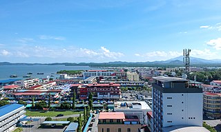
Kudat is the capital of the Kudat District in the Kudat Division of Sabah, Malaysia. Its population was estimated to be around 29,025 in 2010. It is located on the Kudat Peninsula, about 190 kilometres (120 mi) north of Kota Kinabalu, the state capital, and is near the northernmost point of Borneo. It is the largest town in the heartland of the Rungus people which is a sub-ethnic group of the majority Kadazan-Dusun race and is therefore a major centre of Rungus culture. It is also notable for being one of the first parts of Sabah to be settled by Chinese Malaysians, particularly from the Hakka dialect group. It is the Northernmost Malaysian city.
Lahad Datu is the capital of the Lahad Datu District in the Dent Peninsula on Tawau Division of Sabah, Malaysia. Its population was estimated to be around 27,887 in 2010. The town is surrounded by stretches of cocoa and palm oil plantations. It is also an important timber exporting port. The town has an airport for domestic flights.

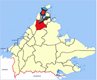
Kudat Division is an administrative division in the state of Sabah, Malaysia. It occupies the northern tip of Sabah. Its total area of 4,623 square kilometres makes it the smallest of the five divisions of Sabah. The division covers the districts of Kudat, Pitas and Kota Marudu, as well as the islands of Balak, Balambangan, Banggi, Bankawan, Guhuan Utara, Kalampunian and Malawali.

Semporna is the capital of the Semporna District in the Tawau Division of Sabah, Malaysia. Its population was estimated to be around 35,301 in 2010.

Papar is the capital of the Papar District in the West Coast Division of Sabah, Malaysia. Its population was estimated to be around 124,420 in 2010, which is divided between Bruneian Malay, Kadazan-Dusun, and Bajau. There is also a sizeable Chinese minority, predominantly of the Hakka subgroup, as well as smaller numbers of other races. The town is located 38 kilometres south of the state capital of Kota Kinabalu, with the Papar railway station in the town becoming one of the main stops of the Sabah State Railway.

Kuala Penyu Town is the capital of the Kuala Penyu District in the Interior Division of Sabah, Malaysia. Its population was estimated to be around 659 in 2010, with ethnic Dusun Tatana sub-group forming the largest single ethnic group.

Sipitang is the capital of the Sipitang District in the Interior Division of Sabah, Malaysia. Its population was estimated to be around 4,298 in 2010. It is the closest town in Sabah to the Sarawak border, and is 44 kilometres south of Beaufort and 144 kilometres south of Kota Kinabalu, the state capital and also is 123 kilometres north of Long Pasia, one of the famous attraction in Sabah.

Keningau is the capital of the Keningau District in the Interior Division of Sabah, Malaysia. It is the fifth-largest town in Sabah, as well one of the oldest. Keningau is between Tambunan and Tenom. The town had an estimated population of 173,130.

Beaufort is the capital of the Beaufort District in the Interior Division of Sabah, Malaysia. It was named after former British Governor Leicester Paul Beaufort. Its population was estimated to be around 12,742 in 2010. It is about 90 kilometres south of Kota Kinabalu and about 167 kilometres north of Long Pasia. It has shophouses built high above the roads to avoid the periodic floods of the Padas River. The population of Beaufort is composed mainly of Bisaya, Brunei Malays, Kadazan-Dusuns, Lun Bawang/Lun Dayeh, Muruts and Chinese. Bisaya are the majority ethnic, and the population is scattered around the town. Like other towns in Sabah such as Kota Kinabalu city, Tawau, Papar, Kudat and Tenom, Beaufort was one of the major initial Hakka population centres in Sabah and still has a large Hakka minority.

Tambunan is the capital of the Tambunan District in the Interior Division of Sabah, Malaysia. Its population was estimated to be around 35,667 in 2010. It is located 80 kilometres east of the state capital, Kota Kinabalu, 48 kilometres south of Ranau and 48 kilometres north of Keningau. At an average altitude of 750 metres, this valley town, which is part of the Crocker Range, experiences a mild tropical climate all year long. The valley is peppered with terraced paddy fields and 70 villages. The dense forests of bamboo around Tambunan town are a legacy of the British colonial period, during which an edict stated that 20 bamboo sprouts had to be planted for every bamboo cut.
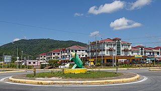
Kota Marudu is the capital of the Kota Marudu District in the Kudat Division of Sabah, Malaysia. Its population was estimated to be around 8,716 in 2010. It is located 130 kilometres north of the state capital, Kota Kinabalu, along the federal highway linking Kota Kinabalu with the town of Kudat, near the northern tip of Borneo.
The Tambanuo people are an indigenous ethnic group residing in Sabah, Malaysia. They reside in Beluran, Kota Marudu, and Pitas districts of Kudat Division of Sabah. Their population was estimated at 20,000 in the year 1990. They are considered a sub-group of the Orang Sungai, and their language belongs to the Paitanic branch of the Austronesian language family.

Malaysia is a country in Southeast Asia. The federal constitutional monarchy consists of thirteen states and three federal territories, separated by the South China Sea into two regions: Peninsular Malaysia and Borneo's East Malaysia. Peninsular Malaysia shares a land and maritime border with Thailand and maritime borders with Singapore, Vietnam, and Indonesia. East Malaysia shares land and maritime borders with Brunei and Indonesia, and a maritime border with the Philippines and Vietnam. Kuala Lumpur is the national capital, the country's largest city, and the seat of the legislative branch of the federal government. Putrajaya is the administrative center, which represents the seat of both the executive branch and the judicial branch of the federal government. With a population of over 32 million, Malaysia is the world's 45th-most populous country. The southernmost point of continental Eurasia is in Tanjung Piai. Located in the tropics, Malaysia is one of 17 megadiverse countries, home to numerous endemic species.

The Kudat District is an administrative district in the Malaysian state of Sabah, part of the Kudat Division which includes the districts of Kota Marudu, Kudat and Pitas. The capital of the district is in Kudat Town.
The Kota Marudu District is an administrative district in the Malaysian state of Sabah, part of the Kudat Division which includes the districts of Kota Marudu, Kudat and Pitas. The capital of the district is in Kota Marudu Town.

The Pitas District is an administrative district in the Malaysian state of Sabah, part of the Kudat Division which includes the districts of Kota Marudu, Kudat and Pitas. The capital of the district is in Pitas Town.

The Semporna District is an administrative district in the Malaysian state of Sabah, part of the Tawau Division which includes the districts of Kunak, Lahad Datu, Semporna and Tawau. The capital of the district is in Semporna Town.

The Tawau District is an administrative district in the Malaysian state of Sabah, part of the Tawau Division which also includes the districts of Kunak, Lahad Datu, Semporna and Tawau. The capital of the district is in Tawau Town.

Ranau is the capital of the Ranau District in the West Coast Division of Sabah, Malaysia. Its population was estimated to be around 8,970 in 2010.

