Plymouth Hoe

Last updated

Plymouth Hoe from Mount Batten in 2006 Plymouth Hoe from Mount Batten (crop).jpg
Plymouth Hoe from Mount Batten in 2006

Plymouth Hoe, referred to locally as the Hoe, is a large south-facing open public space in the English coastal city of Plymouth. The Hoe is adjacent to and above the low limestone cliffs that form the seafront and it commands views of Plymouth Sound, Drake's Island, and across the Hamoaze to Mount Edgcumbe in Cornwall. The name derives from the Anglo-Saxon word hoh, a sloping ridge shaped like an inverted foot and heel (a term that survives in a few other placenames, notably Sutton Hoo). [1]

Contents

History

John Lucas, sergeant, had 8d. for cutting Gogmagog.

—An audit book of 1514. [2]

Until the early 17th century large outline images of the giants Gog and Magog (or Goemagot and Corineus) had for a long time been cut into the turf of the Hoe exposing the white limestone beneath. [3] [4] These figures were periodically re-cut and cleaned. [2] No trace of them remains today, but this likely commemorates the Cornish foundation myth, being the point – Lam Goemagot, 'the Giant's Leap' – from which the Giant was cast into the sea by the hero Corineus. [5]

Plymouth Hoe is perhaps best known for the probably apocryphal story that Sir Francis Drake played his famous game of bowls here in 1588 while waiting for the tide to change before sailing out with the English fleet to engage with the Spanish Armada. The British Library holds a 1591 Spry map of Plimmouth from this era.

A Tudor fortress guarded the neck of water between the eastern Hoe and Mount Batten and some sheer granite and limestone cannon points remain, however in the late 1660s, following The Restoration, a massive star-shaped stone fortress known as the Royal Citadel, was constructed to replace it. Its purpose was to protect the port and probably also to intimidate the townsfolk who had leaned towards Parliament during the Civil War. [6] It remains occupied by the military.

The Belvedere The Colonnade, Plymouth.jpg
The Belvedere

From 1880 there was a popular bandstand on the Hoe. It was removed for scrap metal during the Second World War and never rebuilt. [7] A three tier belvedere built in 1891 survives; [8] it was built on the site of a camera obscura, probably built in the 1830s, which showed views of the harbour. [9] Below this site was the Bull Ring (now a memorial garden), [8] and a grand pleasure pier, started in 1880, which provided a dance hall, refreshment, promenading and a landing place for boat trips. [10] The pier was destroyed by German bombing in World War II.

There is an imposing series of Victorian terraces to the west of the naval memorial which previously continued to the Grand Hotel and, until it was destroyed by bombing, the grand clubhouse of the Royal Western Yacht Club. The club then merged with the Royal Southern and occupied that club's older premises which it had created from the regency public steam baths by the basin at West Hoe before the rejuvenated club moved in the late 1980s to Queen Anne Battery.

Landmarks

Smeaton's Tower, as re-erected on Plymouth Hoe Smeatons Lighthouse on Plymouth Hoe.jpg
Smeaton's Tower, as re-erected on Plymouth Hoe

A prominent landmark on the Hoe is Smeaton's Tower. This is the upper portion of John Smeaton's Eddystone Lighthouse, which was originally built on the Eddystone Rocks, located 14 miles (22.5 km) to the south, in 1759. It was dismantled in 1877 and moved, stone by stone, to the Hoe where it was re-erected. [11]

Smeaton's Tower overlooks Tinside Lido, a 1930s outdoor pool or lido which sits upon the limestone shoreline at the base of the cliff. Most of the works to create the swimming areas and Madeira Road were carried out to make work for the local unemployed during the Depression.

A statue of Sir Francis Drake by Joseph Boehm (a copy of the original in his home town of Tavistock) was placed here in 1884 to commemorate him. [12] There are also several war memorials along the northern side of the Hoe. The largest commemorates the Royal Naval dead of the two world wars; its central obelisk is by Robert Lorimer and was unveiled in 1924, while the surrounding sunken garden was added by Edward Maufe in 1954. [12] [13] The Armada Memorial was opened in 1888 to celebrate the tercentenary of the Spanish Armada. [14]

The Hoe also includes a long broad tarmacked promenade (currently a disabled motorists car park) which serves as a spectacular military parade ground and which is often used for displays by Plymouth-based Royal Navy, Royal Marines, the Army garrison, as well as for travelling funfairs and open-air concerts.

Set into the shape of the southern sea facing fortifications of the Royal Citadel is the Citadel Hill Laboratory of the Marine Biological Association of the UK, which also houses the Sir Alister Hardy Foundation for Ocean Science. Below and to the east, perched on the rocky foreshore is the clubhouse of the Royal Plymouth Corinthian Yacht Club.

Tourism

The Hoe is a popular area for Plymothians and visitors. There is always a great deal of activity on the water, including frequent warship movements, ferries going and coming from France and Spain, fishing trawlers and a swarm of larger and smaller sailing boats. The Fastnet yacht race ends here. The annual two-day British Firework Championships attracts tens of thousands of spectators.

For forty years, there has been controversy about development on the edges of the Hoe green space.[ citation needed ] The erection of two discount hotel chain buildings, at the southern end of Armada Way and the other at the Sound end of Leigham Street, contrast with their Victorian surroundings. The former Grand Hotel has been converted into apartments [15] and the long derelict yacht club site has now been filled by a modern block of flats.

The Plymouth Dome, a turreted and domed building, built into a small old quarry site above Tinside as an historical theme tourist attraction, [16] failed to obtain sufficient funding and closed in 2006, despite having been visited by 2.3 million people. Between 2013 and 2016 it was a restaurant owned by celebrity chef Gary Rhodes. [17]

The view from the Hoe at sunset, showing Plymouth Sound and the Breakwater Plymouth Sound at evening light - geograph.org.uk - 89777.jpg
The view from the Hoe at sunset, showing Plymouth Sound and the Breakwater

Tombstoning

In the early 21st century Plymouth Hoe became notorious for the practice of tombstoning, which involves leaping feet-first into the sea from any accessible high point. This caused a number of serious injuries and deaths, [18] leading to the dismantling of seafront diving boards and closure of parts of the waterfront to discourage the activity. [19]

See also

Related Research Articles

<span class="mw-page-title-main">Plymouth</span> City and unitary authority in England

Plymouth is a port city and unitary authority in South West England. It is located on the south coast of Devon, approximately 36 miles (58 km) south-west of Exeter and 193 miles (311 km) south-west of London. It is bordered by Cornwall to the west and south-west.

<span class="mw-page-title-main">Plymouth Sound</span> Bay

Plymouth Sound, or locally just The Sound, is a deep inlet or sound in the English Channel near Plymouth in England.

<span class="mw-page-title-main">John Smeaton</span> British engineer

John Smeaton was a British civil engineer responsible for the design of bridges, canals, harbours and lighthouses. He was also a capable mechanical engineer and an eminent physicist. Smeaton was the first self-proclaimed "civil engineer", and is often regarded as the "father of civil engineering". He pioneered the use of hydraulic lime in concrete, using pebbles and powdered brick as aggregate. Smeaton was associated with the Lunar Society.

<span class="mw-page-title-main">Eddystone Lighthouse</span> Lighthouse in Cornwall, England

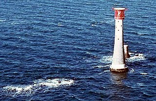
The Eddystone Lighthouse is a lighthouse that is located on the Eddystone Rocks, 9 statute miles (14 km) south of Rame Head in Cornwall, England. The rocks are submerged below the surface of the sea and are composed of Precambrian gneiss.

<span class="mw-page-title-main">Corineus</span> Fighter of giants in medieval British legend

Corineus, in medieval British legend, was a prodigious warrior, a fighter of giants, and the eponymous founder of Cornwall.

<span class="mw-page-title-main">Eddystone Rocks</span> A seaswept and heavily eroded group of rocks southwest of Rame Head

The Eddystone or Eddystone Rocks are a seaswept and eroded group of rocks ranging 9 miles (14 km) southwest of Rame Head in Cornwall, England, United Kingdom. Although the nearest point on the mainland to the Eddystone is in Cornwall, the rocks fall within the city limits of Plymouth, and hence within the county of Devon.

<span class="mw-page-title-main">Mayflower Steps</span> Landmark

<span class="mw-page-title-main">Royal Citadel, Plymouth</span>

The Royal Citadel in Plymouth, Devon, England, was built in the late 1660s to the design of Sir Bernard de Gomme. It is at the eastern end of Plymouth Hoe overlooking Plymouth Sound, and encompasses the site of the earlier fort that had been built in the time of Sir Francis Drake. The citadel site is a Scheduled Monument and many of the buildings within are Grade II Listed.

<span class="mw-page-title-main">Smeaton's Tower</span> Historic lighthouse in England

Smeaton's Tower is a memorial to civil engineer John Smeaton, designer of the third and most notable Eddystone Lighthouse. A major step forward in lighthouse design, Smeaton's structure was in use from 1759 to 1877, until erosion of the ledge it was built upon forced new construction. The tower was largely dismantled and rebuilt on Plymouth Hoe in Plymouth, Devon, where it stands today.

Oreston, formerly a village on the southern bank of the Cattewater, is now a suburb of Plymouth. It is recorded as Horestone on the 1591 Spry Map of Plimmouth. Oreston offers many small, local services. It is home to a small cornershop style shop called "The Quay News," a pub called "The King's Arms," a small dock and free public slipway in "Oreston Quay," and is home to approximately 3,000 residents.

Plymstock School is a state comprehensive secondary school in Plymstock, a suburb of Plymouth, Devon, England. It was the first West Devon comprehensive school and is now a Specialist Sports College. As of January 2011 it has 1,626 students, of whom 240 are in the sixth form. In April 2011, the school became an academy.

<span class="mw-page-title-main">Theatre Royal, Plymouth</span> Theatre in Devon, England

Theatre Royal, Plymouth, is a theatre venue in Plymouth, Devon. It consists of a 1,300-seat main auditorium, The Lyric, which regularly hosts large-scale musicals, opera and ballet; a 200-seat studio, The Drum; and a 50-seat studio, The Lab. On a separate site, Theatre Royal Plymouth also has a production and learning centre, TR2, featuring rehearsal studios and workshops for the production of set and costumes.

<span class="mw-page-title-main">Millbay</span>

<span class="mw-page-title-main">West Hoe</span> Suburb of Plymouth, Devon

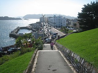
West Hoe is an area of Plymouth in the English county of Devon.

<span class="mw-page-title-main">History of Plymouth</span> History of the city in Devon, England

The History of Plymouth in Devon, England, extends back to the Bronze Age, when the first settlement began at Mount Batten a peninsula in Plymouth Sound facing onto the English Channel. It continued as both a fishing and continental tin trading port through the late Iron Age into the Early Medieval period, until the more prosperous Saxon settlement of Sutton, later renamed Plymouth, surpassed it. With its natural harbour and open access to the Atlantic, the town found wealth and a national strategic importance during the establishment of British naval dominance in the colonisation of the New World. In 1620 the Pilgrim Fathers departed from Plymouth to establish the second English colony in America. During the English Civil War the town was besieged between 1642 and 1646 by the Royalists, but after the Restoration a Dockyard was established in the nearby town of Devonport. Throughout the Industrial Revolution Plymouth grew as a major mercantile shipping industry, including imports and passengers from the US, whilst Devonport grew as a naval base and ship construction town, building battleships for the Royal Navy – which later led to its partial destruction during World War II in a series of air-raids known as the Plymouth Blitz. After the war was over, the city centre was completely rebuilt to a new plan.

<span class="mw-page-title-main">Drake (ward)</span> Ward

Drake is an election ward within Plymouth, Devon, England. One of the main roads from the city to Tavistock and Dartmoor runs through the ward. In the past it played an important role in the supply of water to Plymouth, and it was the location of both a fatal bomb explosion and a large unexploded bomb during the Plymouth Blitz. The University of Plymouth has its main campus in this ward and the large student population has led to part of it being designated as one of the four areas subject to Designated Public Places Orders in the city. It is also the location of the city's main railway station, museum and public library.

<span class="mw-page-title-main">Royal Chapel of St Katherine-upon-the-Hoe</span> Church in Plymouth, England

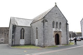
The Royal Chapel of St Katherine-upon-the-Hoe is the garrison church within the precincts of the Royal Citadel in Plymouth. The original church on the site was licensed for services by the Bishop of Exeter, Thomas de Brantingham, in 1371. During the period 1666–1671, the original building was demolished and the present nave, chancel and sanctuary were rebuilt on the same site. The galleries and transepts were added in 1845 and give a symmetrical cross-like structure to the building.

The following is a timeline of the history of the city of Plymouth, Devon, England.

<span class="mw-page-title-main">Armada Memorial</span> Monument in Plymouth, England

The Armada Memorial is a monument on Plymouth Hoe, Plymouth, Devon, England. Built in 1888, the monument celebrates the tercentenary of the defeat of the Spanish Armada, which was sighted by English captains stationed in the city. It is a granite structure, decorated with bronze crests and a statue of Britannia.

References

  1. Matthews, Constance Mary (1974). How place names began, and how they develop. Lutterworth Press. ISBN   9780718820060.
  2. 1 2 Bracken, C. W. (1931). A History of Plymouth and her Neighbours. Plymouth: Underhill. p. 4.
  3. Gray, Todd (2003). Lost Devon: Creation, Change and Destruction over 500 Years. Exeter, Devon: The Mint Press. p. 153. ISBN   1-903356-32-6.
  4. An early and explicit reference is made in Richard Carew (1602), The Survey of Cornwall, text here:. Note that Carew refers to Plymouth Hoe as "the Hawe at Plymmouth".
  5. Geoffrey of Monmouth, Historia Regum Britanniae 1.12–16 on Wikisource
  6. Bridget Cherry & Nikolaus Pevsner (1989). The Buildings of England – Devon. Harmondsworth [Eng.]: Penguin. p. 648. ISBN   0-14-071050-7.
  7. Moseley, Brian (May 2011). "Hoe Bandstand". The Encyclopaedia of Plymouth History. Plymouth Data. Archived from the original on 28 September 2013. Retrieved 13 February 2015.
  8. 1 2 Moseley, Brian (October 2011). "Plymouth, Belvedere and Bull Ring". The Encyclopaedia of Plymouth History. Plymouth Data. Archived from the original on 28 September 2013. Retrieved 13 February 2015.
  9. Moseley, Brian (May 2011). "Camera Obscura". The Encyclopaedia of Plymouth History. Plymouth Data. Archived from the original on 28 September 2013. Retrieved 13 February 2015.
  10. Moseley, Brian (January 2011). "Plymouth, Promenade Pier". The Encyclopaedia of Plymouth History. Plymouth Data. Archived from the original on 7 August 2013. Retrieved 13 February 2015.
  11. "Eddystone Lighthouse". Trinity House . Retrieved 6 September 2006.
  12. 1 2 Cherry, Bridget & Pevsner, Nikolaus (1989). The Buildings of England – Devon. Harmondsworth, Middlesex: Penguin. p. 665. ISBN   0-14-071050-7.{{cite book}}: CS1 maint: multiple names: authors list (link)
  13. Moseley, Brian. "Plymouth, Naval War Memorial". Plymouth Data. Archived from the original on 11 October 2007. Retrieved 2 March 2008.
  14. Worth, Richard (1890). History of Plymouth: From the Earliest Period to the Present Time. Plymouth: W. Brenden. pp.  51–54.
  15. "£8million restoration work begins on Grand Hotel". Plymouth Herald. 16 March 2009. Archived from the original on 5 May 2013. Retrieved 4 May 2010.
  16. Rowe, Mark (5 December 2004). "Family Outings: Plymouth Dome". The Independent. London. Retrieved 4 May 2010.
  17. Blackledge, Sam (13 January 2016). "Gary Rhodes ends involvement with Rhodes @ The Dome as Plymouth restaurant re-brands". Plymouth Herald. Archived from the original on 13 March 2016. Retrieved 26 June 2017.
  18. "Devon deaths warning over Plymouth Hoe tombstoning". BBC News. 18 June 2010.
  19. "'Unsafe' diving platform removed". BBC News. 17 February 2010.

50°21′52″N4°8′32″W / 50.36444°N 4.14222°W / 50.36444; -4.14222