Plymouth railway station

Last updated

Plymouth
National Rail logo.svg
Plymouth (North Road) station (6395408523).jpg
General information
Location Plymouth
England
Coordinates 50°22′40″N4°08′35″W / 50.3778°N 4.1430°W / 50.3778; -4.1430
Grid reference SX476553
Managed by Great Western Railway
Platforms6
Other information
Station codePLY
Classification DfT category C1
History
Original company GWR and LSWR Joint
Post-grouping GWR and SR Joint
Key dates
1877Opened
1938Rebuilding started
1958North Road name dropped
1962Rebuilding completed
Passengers
2018/19Decrease2.svg 2.416 million
 Interchange Decrease2.svg 79,912
Railways in the Plymouth area
BSicon CONTg.svg
BSicon eHST.svg
Plympton
(GWR)
BSicon exCONTgq.svg
BSicon eABZgr+r.svg
BSicon uexCONTgq.svg
BSicon emKRZ.svg
BSicon uexCONTfq.svg
BSicon SKRZ-Gu.svg
BSicon v-SHI2gr.svg
Laira Junction
BSicon lv-DST@G.svg
BSicon exlvHST@F-.svg
BSicon vSTR.svg
Laira TMD
Laira
BSicon BS2+l.svg
BSicon STR+l.svg
BSicon BS2c4.svg
BSicon ABZg+r.svg
BSicon STR.svg
BSicon ABZgxl+l.svg
BSicon STR+r.svg
BSicon exCONT1+r.svg
BSicon STR.svg
BSicon ENDExe.svg
BSicon ENDE@F.svg
Cattewater and Sutton Harbour
BSicon STR2.svg
BSicon cSTRc3.svg
BSicon MASKe.svg
BSicon exlBHF.svg
BSicon exvSHI2l-.svg
Plymouth Friary
BSicon STRc1.svg
BSicon eHST+4.svg
Mutley
(Joint)
BSicon BHF.svg
Plymouth North Road
(Joint)
BSicon eABZgl+l.svg
BSicon exKBHFeq.svg
Plymouth Millbay
(GWR)
BSicon eABZg2.svg
BSicon exSTRc3.svg
BSicon exSTRc1.svg
BSicon HST.svg
BSicon exSTR+4.svg
Devonport Albert Road
(GWR)
BSicon exSTRc2.svg
BSicon TUNNEL1.svg
BSicon exBHF3.svg
Devonport Kings Road
(LSWR)
BSicon exSTRc2.svg
BSicon eKRZ3+1o.svg
BSicon exSTRc4.svg
BSicon dPORTALf.svg
BSicon exdSTR+1.svg
BSicon excSTRc4.svg
BSicon dHST.svg
Dockyard
(GWR)
BSicon extSHI1l.svg
BSicon dSTR.svg
BSicon dPORTALg.svg
BSicon vexHST-STR.svg
Albert Road Halt
(LSWR)
BSicon vexHST-STR.svg
Ford
(LSWR)
BSicon vexHST-STR.svg
Camels Head Halt
(LSWR)
BSicon vexHST-STR.svg
Weston Mill Halt
(LSWR)
BSicon vexSTR-HST.svg
Keyham
(GWR)
BSicon evUSTr.svg
BSicon vSTR-HST.svg
St Budeaux Ferry Road
(GWR)
BSicon vHST-STR.svg
St Budeaux Victoria Road
(LSWR)
BSicon SHI4c1.svg
BSicon lMKRZ2+4o.svg
BSicon STR.svg
BSicon STR2h+4h.svg
BSicon SHI4c3.svg
BSicon CONTg@Gq.svg
BSicon vSTRo-STRr.svg
BSicon hbKRZWae.svg
BSicon CONTf@F.svg
GWR
LSWR

Platform layout

Plymouth station from the east. A CrossCountry train is standing in platform 4. North Road 221128.jpg
Plymouth station from the east. A CrossCountry train is standing in platform 4.
Track layout in 2009 Plymouth track diagram.png
Track layout in 2009

The station has its entrance on the south side which gives access to the city centre. The west side of the station concourse is the ticket office, while on the north and east sides are various retail outlets selling food and newspapers. [18] The buffet on Platforms 7 and 8 is no longer in operation however there is a small café just beyond the ticket barriers serving hot drinks and hot food. The platform area is separated from the concourse by the ticket gates.

The platforms that can be reached on the level from the concourse are numbered 1 to 4. Platforms 1 and 2 are east-facing bay platforms, not used by passenger trains. Platform 3 is a west-facing bay platform that is mainly used by local services to Gunnislake and sometimes Penzance. [11] [19]

The remaining platforms are reached by a subway immediately inside the ticket gates; there are lifts to the subway on each of the groups of platforms. [7] They are all through tracks and are signalled so that trains can arrive and depart in either direction. [19] Platform 4 is used by most through services towards Penzance, but also for some trains towards London. Platforms 5 and 6 are either side of the middle island platform and are used by a variety of services, including Great Western Railway local trains and long distance CrossCountry services. Platforms 7 and 8 are either side of a second island platform; there is a small coffee shop facing the subway steps on this platform. Most Great Western Railway services to London Paddington depart from platform 7, but both these platforms are used by a variety of services from Cornwall towards London and the North as well as some local services. [11]

Beyond Platform 8 are two tracks, known as Park Sidings, which are used for stabling trains between services, but most trains are nowadays kept on the platform tracks between arrival and departure. There are some more sidings adjacent to platform 1. There is an extra track between platforms 4 and 5 for through goods trains and shunting manoeuvres. [19]

Brunel Plaza

The railway station and surrounding area is undergoing a redevelopment in 2020-2024. Intercity Place, an 11 floor tower next to the station, is being rebuilt for use by the University of Plymouth and the existing three-story car park is being replaced by a new six-story car park on the site of the current Rail Incident Safety Centre building which will be relocated to a new building to the west of the station. [20] The old car park will then be demolished and turned into potential sites for more University buildings including a new accommodation block [21] and a hotel. The construction works began in late 2020, [22] the University building is due to open in 2023, the car park in 2024, and all other works are due to be completed by 2027. [23]

Services

Great Western Railway services to Penzance on platforms 5 and 4 respectively 43016 and 802113 PLY.jpg
Great Western Railway services to Penzance on platforms 5 and 4 respectively

Plymouth is served by Great Western Railway trains on the main line from London Paddington, some of which terminate at Plymouth but many continue over the Cornish Main Line to Penzance or, in the summer, Newquay. Services between London Paddington to Plymouth are at least hourly throughout the day. A number of named trains operate on this route including the Cornish Riviera , a fast London to Penzance daytime service, and the overnight Night Riviera service on the same route.

Most CrossCountry trains from Scotland and the North of England via Bristol terminate at Plymouth, although 2 continue to Penzance, and, on summer weekends, Newquay. [24] From Plymouth, most services terminate at Edinburgh Waverley via Birmingham New Street, however, 1 train per day operates towards both Glasgow Central and Aberdeen respectively. [25]

Local services are provided by Great Western Railway along the Cornish Main Line, often extended eastwards to and from Newton Abbot, Exeter St Davids and beyond. Services are also provided on the Tamar Valley Line to Gunnislake. [8]

Preceding station National Rail logo.svg National Rail Following station
Devonport   Great Western Railway
Tamar Valley Line
 Terminus
  Great Western Railway
Exeter to Plymouth Line
  Ivybridge
Liskeard   CrossCountry
Cornwall and Plymouth to the North
  Totnes

Passenger volume

Plymouth has the third largest number of passengers starting or finishing their journey in Devon, after Exeter Central and Exeter St Davids. Comparing the year from April 2008 to that which started in April 2002, passenger numbers increased by 97%. [26] However, recent years have seen little further growth.

 200203200405200506200607200708200809200910201011201112201213201314201415201516201617201718201819
Entries721,187767,066822,804929,1051,018,9411,344,6411,139,3591,200,5411,298,3731,289,6581,222,7321,247,6241,243,7811,254,7261,224,5471,208,188
Exits710,487751,945806,207916,8081,007,9101,344,6401,139,3591,200,5411,298,3731,289,6581,222,7321,247,6241,243,7811,254,7261,224,5471,208,188
Interchangesunknown55,15468,83277,72861,934133,49667,19473,574104,598unknown88,48893,42395,082100,53190,29979,912
Total1,431,6741,585,1651,697,8431,923,6862,088,7852,822,7772,345,9122,474,6562,701,3442,579,3162,533,9522,588,6712,582,6442,609,9832,539,3932,496,288

The statistics cover twelve month periods that start in April. [26]

Signalling

The signal box built in 1960 2008 at Plymouth station - Panel Signal Box.jpg
The signal box built in 1960

The station was originally controlled from two signal boxes. "North Road East" was on the north side of the line to the east of the station, while "North Road West" was on the south side of the line at the west end of the station where it could control the junction of the original lines to Millbay with the new Cornwall Loop Line to Devonport. The adjacent signal boxes were at Mutley to the east, Cornwall Junction on the Millbay line, and Devonport Junction at the far end of the Cornwall Loop. [27]

Both of the North Road signal boxes were closed in November 1908 and replaced by new ones with the same names. The West box was now on the north side of the line and had 59 levers, while the East box needed just 48. They were each 38 feet (11.6 m) long. Mutley box closed at the same time, the next box now being at Mannamead on the other side of Mutley Tunnel, which had opened about three years earlier. [27]

The rebuilding work of 1938 meant more signalling alterations. On 22 January 1938, the timber West box was lifted up and moved to a new position clear of the proposed works, being brought back into use on 27 January 1938. At the other end of the station the East box was closed and a new 79 feet (24.1 m) structure built, again on the north side of the line, which was brought into use on 25 June 1939. [27]

Both signal boxes were closed on 26 November 1960 when a new "Plymouth Panel Signal Box" was opened on the west end of the new Platform 1; the West box was subsequently demolished. Multiple-aspect signals have controlled movements of trains throughout the Plymouth area since the opening of this new signal box in 1960. The adjacent boxes were initially at Laira Junction in the east and Keyham in the west. [27] The area of control was extended westwards on 2 July 1973 to meet the signal box at St Germans, which closed in 1998 [28] so the next signal box westwards is now at Liskeard railway station. Towards the end of 1973 several more signal boxes were closed eastwards from Plymouth, which meant that Plymouth controlled trains until they reached the outer signal of Totnes Signal Box. Totnes box closed on 9 November 1987 [7] when a new panel signal box at Exeter was opened. The Panel Signal Box at the station controls all trains between (but not at) Totnes in Devon, and Liskeard in Cornwall.

See also

Related Research Articles

<span class="mw-page-title-main">Tarka Line</span> Local railway line in Devon, England

The Tarka Line, also known as the North Devon Line, is a local railway line in Devon, England, linking the city of Exeter with the town of Barnstaple via a number of local villages, operated by Great Western Railway (GWR). The line opened in 1851 from Exeter to Crediton and in 1854 the line was completed through to Barnstaple. The line was taken over by the London and South Western Railway (LSWR) in 1865 and later became part of the Southern Railway and then British Rail. In 2001, following privatisation, Wessex Trains introduced the name Tarka Line after the eponymous character in Henry Williamson's book Tarka the Otter. The line was transferred to First Great Western in 2006.

<span class="mw-page-title-main">Exeter St Davids railway station</span> Railway station in Devon, England

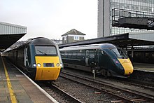
Exeter St Davids railway station is the principal railway station serving the city of Exeter in Devon, England. It is 193 miles 72 chains from the zero point at London Paddington, on the line through Bristol which continues to Plymouth and Penzance. It is also served by an alternative route to London Waterloo, via Salisbury, and branch lines to Exmouth, Barnstaple and Okehampton. It is currently managed by Great Western Railway and is served by trains operated by Great Western Railway, South Western Railway and CrossCountry. It is the busiest station in Devon, and the third busiest station in South West England.

<span class="mw-page-title-main">Plymouth, Devonport and South Western Junction Railway</span> Former English railway company

The Plymouth, Devonport and South Western Junction Railway (PD&SWJR) was an English railway company. It constructed a main line railway between Lydford and Devonport, in Devon, England, enabling the London and South Western Railway (LSWR) to reach Plymouth more conveniently than before.

<span class="mw-page-title-main">Devonport railway station</span> Railway station in Devon, England

Devonport railway station serves the Devonport area of Plymouth in Devon, England. It is 248 miles 28 chains (399.7 km) from London Paddington measured via Box and Plymouth Millbay. It is managed by Great Western Railway.

<span class="mw-page-title-main">Keyham railway station</span> Railway station in Devon, England

Keyham railway station is a suburban station in the city of Plymouth, Devon, England. It is 249 miles 25 chains (401.2 km) from London Paddington via Box and Plymouth Millbay. The station is close to the Devonport dockyard.

<span class="mw-page-title-main">St Budeaux Ferry Road railway station</span> Railway station in Devon, England

St Budeaux Ferry Road railway station is a suburban station in St Budeaux, Plymouth, England. It is 250 miles 15 chains (402.6 km) from London Paddington via Box and Plymouth Millbay.

<span class="mw-page-title-main">Par railway station</span> Railway station in Cornwall, England

Par railway station serves the villages of Par, Tywardreath and St Blazey, Cornwall, England. The station is 281 miles 66 chains from the zero point at London Paddington measured via Box and Plymouth Millbay. It is the junction for the Atlantic Coast Line to Newquay.

<span class="mw-page-title-main">Plymouth Millbay railway station</span> Former railway station in Plymouth, England

Plymouth Millbay railway station was the original railway terminus in Plymouth, Devon, England. It was used for passenger trains from 1849 to 1941. It was rebuilt in 1903.

<span class="mw-page-title-main">South Devon and Tavistock Railway</span> Railway line in England

The South Devon and Tavistock Railway linked Plymouth with Tavistock in Devon; it opened in 1859. It was extended by the Launceston and South Devon Railway to Launceston, in Cornwall in 1865. It was a broad gauge line but from 1876 also carried the standard gauge trains of the London and South Western Railway between Lydford and Plymouth: a third rail was provided, making a mixed gauge. In 1892 the whole line was converted to standard gauge only.

Launceston railway station was situated in Launceston, Cornwall, England, United Kingdom. It was served by both the Great Western Railway (GWR) and London and South Western Railway (LSWR).

<span class="mw-page-title-main">Disused railway stations on the Exeter to Plymouth Line</span>

There are eleven disused railway stations on the Exeter to Plymouth line between Exeter St Davids and Plymouth Millbay in Devon, England. At eight of these there are visible remains.

There are seventeen disused railway stations on the Cornish Main Line between Plymouth in Devon and Penzance in Cornwall, England. The remains of nine of these can be seen from passing trains. While a number of these were closed following the so-called "Beeching Axe" in the 1960s, many of them had been closed much earlier, the traffic for which they had been built failing to materialise.

<span class="mw-page-title-main">Exeter to Plymouth railway of the LSWR</span>

The Exeter to Plymouth railway of the London and South Western Railway (LSWR) was the westernmost part of a route competing with that of the Great Western Railway (GWR) and its 'associated companies' from London and Exeter to Plymouth in Devon, England. Whereas the GWR route from Exeter followed the coast to Newton Abbot and then went around the southern edge of Dartmoor, the LSWR route followed the northern and western margins of Dartmoor, passing through the towns of Crediton, Okehampton, and Tavistock.

<span class="mw-page-title-main">Lydford railway station</span> Disused railway station in Devon, England

Lydford railway station was a junction at Lydford between the Great Western Railway (GWR) and London and South Western Railway (LSWR) situated in a remote part of north-west Dartmoor in Devon, England.

The Langport and Castle Cary Railway is a railway line from Castle Cary railway station to Cogload Junction near Taunton, Somerset, England, which reduced the length of the journey from London to Penzance by 20+14 miles (32.6 km).

<span class="mw-page-title-main">Railways in Plymouth</span> Overview of railways in Plymouth, Devon, England

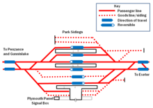
The network of railways in Plymouth, Devon, England, was developed by companies affiliated to two competing railways, the Great Western Railway and the London and South Western Railway. At their height two main lines and three branch lines served 28 stations in the Plymouth area, but today just six stations remain in use.

<span class="mw-page-title-main">Devonport Kings Road railway station</span> Disused railway station in Devon, England

Devonport Kings Road railway station was the London and South Western Railway station in Devonport, Devon, England. It opened in 1876 and closed in 1964. For the first 14 years it was a terminal station with trains to London departing eastwards, but from 1890 it became a through station with trains to London departing westwards.

<span class="mw-page-title-main">Plymouth Friary railway station</span> Former railway station in England

Plymouth Friary railway station was the London and South Western Railway (LSWR) terminus in Plymouth, Devon, England.

<span class="mw-page-title-main">Plymouth to Yealmpton Branch</span>

The Plymouth to Yealmpton Branch was a Great Western Railway single track branch railway line in Devon, England, that ran from Plymstock to Yealmpton. The line was planned as part of a route to Modbury, but the scheme was cut back to Yealmpton; it opened in 1898, and the passenger train service ran from Plymouth Millbay, but road competition led to declining usage and the passenger service was withdrawn in 1930.

<span class="mw-page-title-main">Exeter–Plymouth line</span> Railway line in Devon, England

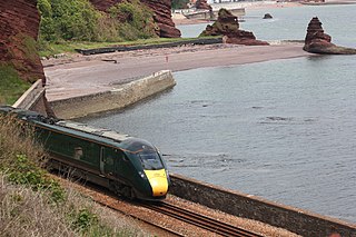
The Exeter–Plymouth line, also called the South Devon Main Line, is a central part of the trunk railway line between London Paddington and Penzance in the southern United Kingdom. It is a major branch of the Great Western Main Line and runs from Exeter St Davids to Plymouth, from where it continues as the Cornish Main Line. It was one of the principal routes of the Great Western Railway which in 1948 became part of the Western Region of British Railways and is presently operated by Network Rail.

References

  1. Padgett, David (June 2018) [1989]. Munsey, Myles (ed.). Railway Track Diagrams 3: Western & Wales (6th ed.). Frome: Trackmaps. map 9B. ISBN   978-1-9996271-0-2.
  2. 1 2 "National Rail Timetable 135 (Summer 2014)" (PDF). Network Rail. Archived from the original (PDF) on 10 January 2015. Retrieved 6 July 2014.
  3. Perry, George, ed. (1970). 'The Book of the Great Western. London: Sunday Times Magazine. ISBN   0-7230-0018-2.
  4. Gregory, R H (1982). The South Devon Railway. Salisbury: Oakwood Press. ISBN   0-85361-286-2.
  5. MacDermot, E T (1931). History of the Great Western Railway, volume II 1863-1921. London: Great Western Railway.
  6. 1 2 Smith, Martin (1995). An Illustrated History of Plymouth's Railways. Caernarfon: Irwell Press. ISBN   1-871608-41-4.
  7. 1 2 3 4 5 Oakley, Mike (2007). Devon Railway Stations. Wimbourne: The Dovecote Press. ISBN   978-1-904349-55-6.
  8. 1 2 "National Rail Timetable 139 (Summer 2014)" (PDF). Network Rail. Retrieved 6 August 2014.
  9. Lawrence, David (2018). British Rail Architecture 1948-97. Crecy Publishing Ltd. p. 62. ISBN   9780860936855.
  10. Mosley, Brian. "A Plan for Plymouth". Encyclopedia of Plymouth History. Plymouth Data. Retrieved 22 August 2008.
  11. 1 2 3 "Plymouth". Live Departures and Arrivals. National Rail. Retrieved 22 July 2008.
  12. Eve, Carl (10 April 2014). "Ten-year plan for redevelopment of Plymouth Rail Station is now underway, says council". Evening Herald. Plymouth. Archived from the original on 18 October 2014. Retrieved 18 October 2014.
  13. "Network Rail Report 2009 (Report from Network Rail, 2009)" (PDF). Network Rail. Retrieved 5 August 2016.[ permanent dead link ]
  14. "18 injured in 'low impact' Plymouth train crash". BBC News. 3 April 2016. Retrieved 3 April 2016.
  15. Lewis-Herald, J (3 April 2016). "Plymouth train crash: Investigation launched after 18 left injured by 'low-speed' collision". The Herald. Local World. Retrieved 4 April 2016.[ permanent dead link ]
  16. "Collision at Plymouth station". Rail Accidents Investigation Branch. Retrieved 18 April 2016.
  17. "Report 02/2017 Collision at Plymouth station 3 April 2016" (PDF). Rail Accidents Investigation Branch. Retrieved 13 February 2016.
  18. "Plymouth". Station Facilities. National Rail. Retrieved 22 July 2008.
  19. 1 2 3 Jacobs, Gerald (2005). Railway Track Diagrams Book 3: Western. Bradford-on-Avon: Trackmaps. ISBN   0-9549866-1-X.
  20. "TCF Outline Business Case Plymouth Station: Station Forecourt Interchange" (PDF). Plymouth City Council. 15 February 2021. Retrieved 29 March 2023.
  21. Clark, Daniel (16 June 2022). "Plymouth railway station is set to get a new approach". PlymouthLive. Retrieved 29 March 2023.
  22. Oldfield, Ed; Telford, William (11 August 2020). "Work begins on £80m Plymouth railway station redevelopment". Business Live. Retrieved 29 March 2023.
  23. Telford, William (14 July 2021). "Timeline revealed for £80m Plymouth Railway Station redevelopment". Business Live. Retrieved 29 March 2023.
  24. "National Rail Timetable 51 (Summer 2014)" (PDF). Network Rail. Retrieved 6 August 2014.
  25. "CrossCountry Timetable December 2023-June 2024" (PDF). Retrieved 12 March 2024.
  26. 1 2 "Station Usage". Rail Statistics. Office of Rail Regulation. Archived from the original on 4 July 2012. Retrieved 25 March 2010.
  27. 1 2 3 4 Crozier, Larry (2000). Mechanical Signalling in Plymouth. Wallasey: Signalling Record Society. ISBN   1-873228-18-X.
  28. Pryer, GA (2000). Signal Box Diagrams of the Great Western & Southern Railways, Volume 14: GWR Lines Plymouth and East Cornwall. Weymouth: GA Pryer. ISBN   0-9532460-5-1.

Further reading

This station offers access to the South West Coast Path
Distance to path1 mile (1.6 km)
Next station anticlockwise Kingswear 65 miles (105 km)
Next station clockwise Looe 21 miles (34 km)