
A quilombo is a Brazilian hinterland settlement founded by people of African origin, and others sometimes called Carabali. Most of the inhabitants of quilombos, called quilombolas, were maroons, a term for escaped slaves.

The Bissagos Islands, also spelled Bijagós, are a group of about 88 islands and islets located in the Atlantic Ocean off the coast of Guinea-Bissau. The archipelago was formed from the ancient delta of the Geba and Grande de Buba rivers and spans an area of 12,958 km2 (5,003 sq mi). 20 of its islands are populated year-round, including the most populated island, Bubaque, where the administrative capital is situated.

Cape Palmas is a headland on the extreme southeast end of the coast of Liberia, Africa, at the extreme southwest corner of the northern half of the continent. The Cape itself consists of a small, rocky peninsula connected to the mainland by a sandy isthmus. Immediately to the west of the peninsula is the estuary of the Hoffman River. Approximately 21 km (15 mi) further along the coast to the east, the Cavalla River empties into the sea, marking the border between Liberia and the Côte d'Ivoire. It marks the western limit of the Gulf of Guinea, according to the International Hydrographic Organization (IHO).
Boké is the capital city of Boké Prefecture within the Boké Region of Lower Guinea near the border with Guinea-Bissau. It is also a sub-prefecture of Guinea. Located along the Rio Nuñez which flows to its not-too-distant mouth on the Atlantic Ocean, Boké is a port. It is known for the Boké Museum, formerly a slave fort. The town is served by Boké Baralande Airport. As of 2014 the city and surrounding sub-prefecture had a population of 61,449 people.

Îles de Los[il də lo] are an island group lying off Conakry in Guinea, on the west coast of Africa. Their name is derived from the Portuguese: Ilhas dos Ídolos, "Islands of the Idols". They are located about two kilometres off the headland limiting the southern side of Sangareya Bay.
Baga, or Barka, is a dialect cluster spoken by the Baga people of coastal Guinea. The name derives from the phrase bae raka 'people of the seaside'. Most Baga are bilingual in the Mande language Susu, the official regional language. Two ethnically Baga communities, Sobané and Kaloum, are known to have abandoned their (unattested) language altogether in favour of Susu.

The Baga are a West African ethnic group who live in the southern swampy lands of Guinea Atlantic coastline. Traditionally animist through the pre-colonial times, they converted to Islam during the mid-eighteenth century under the influence of Muslim Mandé missionaries. Some continue to practice their traditional rituals.

Rivières du Sud was a French colonial division in West Africa, roughly corresponding to modern coastal sections of Guinea. While the designation was used from the 18th to 20th century, the administrative division only existed from 1882-1891.

The Muni is an estuary of several rivers of Equatorial Guinea and Gabon. Part of its length form part of the border with Gabon. It is from this estuary that the former name for this part of Equatorial Guinea, Río Muni was taken.

Guinean Americans are an ethnic group of Americans of Guinean descent. According to estimates by 2000 US Census, there were 3,016 people who identified Guinean as one of their two top ancestry identities. However, in November 2010 the New York Times estimated that as many 10,000 Guineans and Guinean Americans reside in New York City alone.
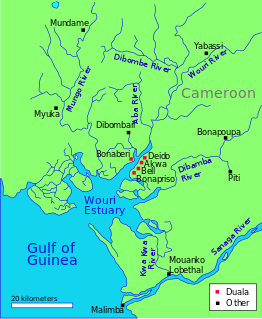
The Wouri estuary, or Cameroon estuary is a large tidal estuary in Cameroon where several rivers come together, emptying into the Bight of Biafra. Douala, the largest city in Cameroon, is at the mouth of the Wouri River where it enters the estuary. The estuary contains extensive mangrove forests, which are being damaged by pollution and population pressures.

Nunez River or Rio Nuñez (Kakandé) is a river in Guinea with its source in the Futa Jallon highlands. It is also known as the Tinguilinta River, after a village along its upper course.

African Slave Trade Patrol was part of the Blockade of Africa suppressing the Atlantic slave trade between 1819 and the beginning of the American Civil War in 1861. Due to the abolitionist movement in the United States, a squadron of U.S. Navy warships and Cutters were assigned to catch slave traders in and around Africa. In 42 years about 100 suspected slave ships were captured.
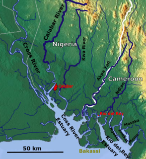
The Rio del Rey is an estuary of a drainage basin in West Africa in Cameroon. It is located in the eastern area of the Niger River system. The Cameroon volcanic line separates Rio Del Rey from the Douala basin. Rio del Rey has been described as an estuary in which "the two rivers N'dian and Massake flow out". The mouth is close to the border with Nigeria and has connections to the Cross River estuary from which it is separated by the Bakassi peninsula. The Rio del Rey estuary has been designated as a Ramsar site since 2010.
Farenya is a settlement in Boffa Prefecture, Boké Region, Guinea. It is situated 69 miles north of Conakry. It is located on the Pongo River.
Niara Bely, also known as Elizabeth Bailey Gomez, was a Luso-African queen who became a prominent businesswoman in nineteenth century Guinea. She was active in the slave trade in Farenya, Guinea.
John Holman was an English slave trader from London who settled in the Pongo River area in the 1760s before eventually moving on to South Carolina in 1790.
Sandown is notable because when in 1793-94 she carried slaves from Sierra Leone to Jamaica, her master, Captain Samuel Gamble, kept a detailed log with profuse illustrations. This has been published in a transcribed and annotated form. It is one of only a few journals and logbooks from the British slave trade.
Mary Faber, also called Mary Faber de Sanger,, was an African slave-trader. From the 1830s until 1852, she was a dominant figure of the Atlantic slave trade from Guinea, and known for her conflict with the British Royal Navy Anti-Slave Squadron.

Théodore Canot (1804–1860) was a slave trader and writer of Franco-Florentine origin.
