
Kottayam is one of 14 districts in the Indian state of Kerala. Kottayam district comprises six municipal towns: Kottayam, Changanassery, Pala, Erattupetta, Ettumanoor, and Vaikom. It is the only district in Kerala that does not border either the Arabian Sea or another Indian state.

Kanjirappally is a taluk and a town in Kottayam district situated about 38 km (24 mi) away from the district capital, in the state of Kerala, in southwestern India.
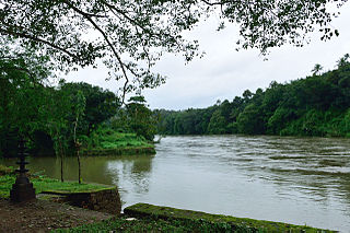
Mundakayam, is a town in Kanjirappally Taluk in the Kottayam District of Kerala. It is the doorway to the high ranges of southern Kerala, and is at the border of Kottayam and Idukki districts. The next nearest town, Kanjirappally, is 14 km (8.7 mi) & Erumely is 12 km from Mundakayam. Mundakayam has rubber plantations, and greenery. The Manimala River runs through Mundakayam. It is located 48 km east of the district headquarters at Kottayam and 148 km from the state capital, Thiruvananthapuram. The name Mundakayam is said to be derived from the Mundi cranes that used to be seen along the Manimala River banks.
Koottickal is a town at the base of Western Ghats mountain ranges in the Kottayam district, in the state of Kerala. It is 2,000 feet (610 m) above sea level and is situated on the eastern border of Kottayam District, 55 km from Kottayam, and around 5 km away from Mundakayam on the NH 220. There are streams and waterfalls in the surrounding places. The Muthukora Hills are nearby. Urban centres in Kottayam and Ernakulam districts can be viewed from the top of Muthukora Hills.

Uzhavoor is an expanding town in Kottayam district, Kerala in India. It is just 32 km away from the administrative capital Kottayam District. Most of its residents are either wealthy farmers or businessmen. Many of the houses belong to NRIs. The tenth President of India, K. R. Narayanan, was born and brought up in this village. The newly expanded road which connects the city of Pala and other destinations such as Sabarimala to the city of Muvattupuzha passes through Uzhavoor. The town is 177 km from the state capital Thiruvananthapuram.

Karukachal is a fast-growing town in Changanassery Taluk in Kottayam district of Kerala state in India. The name "Karukachal" was coined from the words "Karuka"(Karukapullu in Malayalam) which is a type of grass which grew in plenty and "chal" meaning a small body of flowing water. Karukachal in Changanacherry-Vazhoor Road which is almost a century old.The next nearest town, Chanaganasserry, is 14 km & Kottayam is 20 km from Karukachal.
The Main Central Road popularly known as MC Road is the arterial State Highway starting from Kesavadasapuram in Trivandrum city and ends at Angamaly, a suburb of Kochi city in Ernakulam District, in the state of Kerala, India. It is designated as State Highway 1 by the Kerala Public Works Department. The highway was built by Raja Kesavadas, Dewan of Travancore, in the 1790s. Plan for a new highway called Thiruvananthapuram–Angamaly Greenfield Highway, which runs parallel to the MC Road is proposed and is under early stage of development.

Chengannur is a municipality in the Alappuzha district of Kerala, India. It is located 37 km (23.0 mi) south of the district headquarters in Alappuzha and about 98 km (60.9 mi) north of the state capital Thiruvananthapuram. As per the 2011 Indian census, Chengannur has a population of 23,466 people, and a population density of 1,607/km2 (4,160/sq mi).

Pathanamthitta, is a municipality situated in the Southern Kerala, India, spread over an area of 23.50 km2. It is the administrative capital of Pathanamthitta district. The town has a population of 37,538. The Hindu pilgrim centre Sabarimala is situated in the Pathanamthitta district; as the main transport hub to Sabarimala, the town is known as the 'Pilgrim Capital of Kerala'. Pathanamthitta District, the thirteenth revenue district of the State of Kerala, was formed with effect from 1 November 1982, with headquarters at Pathanamthitta. Forest covers more than half of the total area of the District. Pathanamthitta District ranks the 7th in area in the State. The district has its borders with Allepey, Kottayam, Kollam and Idukki districts of Kerala and Tamil Nadu. Nearest city Is Thiruvalla, located at a distance of 30 km. Thiruvalla railway station Is 30 km via Thiruvalla-Kumbazha highway. Buses ply every 5 Minutes from Thiruvalla To Pathanamthitta & vice versa.
Manimala is a small town and a village in Kottayam district in the Indian state of Kerala, situated about 12 kilometres (7.5 mi) from the nearest town Kanjirappally. It was declared a folklore village in 2011 by the central government to promote folklore.

Kumily, also spelt as Kumaly is a revenue village and Gram Panchayat in the Idukki district of the state of Kerala. It is a town in Cardamom Hills near Thekkady and Periyar Tiger Reserve. Kumily is a gateway town into Kerala from Tamil Nadu.

Mallikassery is a small village near Paika, in Elikulam Panchayat of Kanjirappally Taluk in Kottayam district, in the state of Kerala, India.
Chunkappara is a small town in the Pathanamthitta district of Kerala state, South India. Chunkappara is situated 26 km (16 mi) east of the town of Thiruvalla, where the nearest railway station is located. Other neighbouring towns include Kanjirappally, Ranny, and Erumely.

Erumely, also spelt Erumeli, is a town and panchayat located in the south-eastern part of Kottayam district in Kerala state, India. Erumely is situated 49 km (30 mi) east of Kottayam town and 133 km (83 mi) north of capital city Thiruvananthapuram. It is situated on the way to Sabarimala and during pilgrimage season, Erumely and its surroundings will be crowded by devotees from different parts of Kerala as well as other states. Erumely is also renowned for its religious harmony and prosperity between Hindus and Muslims which existed from the early periods. It is a place which have strong roots in legends and myths associated with Hindu deity Ayyappa. A new airport has been proposed in Erumeli. The village is nourished by Manimala River.
Kodungoor is a town in Kottayam District, Kerala, India.

The Main Eastern Highway is the lifeline of the high range townships of the Travancore region of Kerala state, India. It is also known as Punalur-Muvattupuzha Highway. Main Eastern Highway is categorized as State Highway - 08 of Kerala. It is the second longest State Highway of Kerala covering a distance of 153.6 km. The districts it passes through are Kollam, Pathanamthitta, Kottayam, Idukki and Ernakulam.

Yendayar is a village in Kottayam district, Kerala, India that is totally surrounded by hills. According to local tradition, Mr. J.J. Murphy named the place, which was to be his home until death in 1957, after his mother and the local river. Yendayar is a combination of 'yen' (my) 'thai' (mother) and 'ar' (river). Murphy had come in 1904 to the place which was a thick forest and had no name or people then. He had traveled a long way to reach there. There he established India's first successful rubber plantation. He brought workers from near and far – Kerala, Tamil Nadu, and Karnataka.
Koruthodu is a village/town in Kanjirappally Taluk, Kottayam District of Kerala state, India. It is situated on the Highway connecting Mundakayam to Sabarimala temple, Kerala, and is at the border of Pathanamthitta, Kottayam and Idukki districts. The nearest town Mundakayam is 13 Kilometers from Koruthodu. The river Azhutha runs through the borders of this village. Nearby locations include Kanamala, Vandanpathal, Mundakkayam and Panakkachira.
Sabarimala Railway is a proposed 111-kilometre (69 mi)-long railway line in Kerala, India, that will run from Angamaly to Erumeli. It was sanctioned in 1998 by Indian Railways. The line's name comes from the fact that it will provide a railway facility to pilgrims visiting the Sabarimala Temple.
Parathanam is a Town at the base of Western Ghats mountain ranges in the Kottayam district, Kerala. It is 2,000 feet above sea level and is situated on the eastern border of Kottayam District, 60 km from Kottayam, 12 km away from Poonjar and around 8 km away from Mundakayam on the NH 220.


