Related Research Articles

The demographics of Israel, monitored by the Israel Central Bureau of Statistics, encompass various attributes that define the nation's populace. Since its establishment in 1948, Israel has witnessed significant changes in its demographics. Formed as a homeland for the Jewish people, Israel has attracted Jewish immigrants from Europe, Asia, Africa, and the Americas.

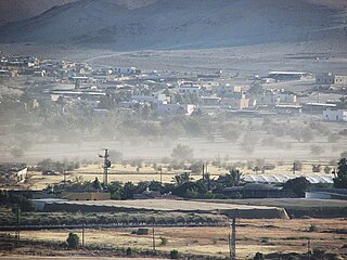
Israeli settlements, also called Israeli colonies, are the civilian communities built by Israel throughout the Israeli-occupied territories. They are populated by Israeli citizens, almost exclusively of Jewish identity or ethnicity, and were first established after Israel's victory in the Six-Day War of June 1967. The international community considers Israeli settlements to be illegal under international law, but Israel disputes this. The expansion of settlements often involves the confiscation of Palestinian land and resources, leading to displacement of Palestinian communities and creating a source of tension and conflict. Settlements are often protected by the Israeli military and are frequently flashpoints for violence against Palestinians. Further, the presence of settlements and Jewish-only bypass roads creates a fragmented Palestinian territory, seriously hindering economic development and freedom of movement for Palestinians.

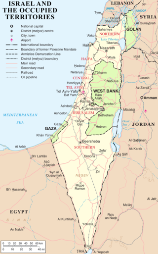
The West Bank, so called due to its relation to the Jordan River, is the larger of the two Palestinian territories. A landlocked territory near the coast of the Mediterranean Sea in the Levant region of West Asia, it is bordered by Jordan and the Dead Sea to the east and by Israel to the south, west, and north. The territory has been under Israeli occupation since 1967.

The Israeli–Palestinian conflict is an ongoing military and political conflict about self-determination within the territory of the former Mandatory Palestine. Key aspects of the conflict include the Israeli occupation of the West Bank and Gaza Strip, the status of Jerusalem, Israeli settlements, borders, security, water rights, Palestinian freedom of movement, and the Palestinian right of return.

Gaza, also called Gaza City, is a Palestinian city in the Gaza Strip. Before the 2023 Israel–Hamas war, it was the most populous city in the State of Palestine, with 590,481 in 2017.

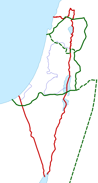
The Palestinian territories are the two regions of the former British Mandate for Palestine that have been occupied by Israel since the Six-Day War of 1967, namely the West Bank and the Gaza Strip. The International Court of Justice (ICJ) has referred to the West Bank, including East Jerusalem, as "the Occupied Palestinian Territory", and this term was used as the legal definition by the ICJ in its advisory opinion of July 2004. The term occupied Palestinian territory was used by the United Nations and other international organizations between October 1999 and December 2012 to refer to areas controlled by the Palestinian National Authority, but from 2012, when Palestine was admitted as one of its non-member observer states, the United Nations started using exclusively the name State of Palestine. The European Union (EU) also uses the term "occupied Palestinian territory". The government of Israel and its supporters use the label "disputed territories" instead.

Rafah is a Palestinian city in the southern Gaza Strip; it is the capital of the Rafah Governorate of the State of Palestine, located 30 kilometers (19 mi) south-west of Gaza City. In 2017, Rafah had a population of 171,889. As a result of massive bombardment and ground assaults in Gaza City and Khan Yunis by Israel during the Israel–Hamas war, about 1.4 million people are believed to be sheltering in Rafah as of February 2024.

In 2005, 21 Israeli settlements in the Gaza Strip were unilaterally dismantled and Israeli settlers and army evacuated from inside the Gaza Strip, redeploying its military along the border.
The population statistics for Israeli settlements in the West Bank are collected by the Israel Central Bureau of Statistics. As such, the data contains only population of settlements recognized by the Israeli authorities. Israeli outposts, which are illegal by Israeli law, are not tracked, and their population is hard to establish. All settlements in the West Bank were advised by the International Court of Justice to be unlawful.

Yamit was an Israeli settlement in the northern part of the Sinai Peninsula with a population of about 2,500 people. Yamit was established during Israel's occupation of the peninsula from the end of the 1967 Six-Day War until that part of the Sinai was handed over to Egypt in April 1982, as part of the terms of the 1979 Egypt–Israel peace treaty. Prior to the return of the land to Egypt, all the homes were evacuated and bulldozed.
Palestine is a geographical region in West Asia. Situated in the Southern Levant, it is usually considered to include Israel and the State of Palestine, though some definitions also include parts of northwestern Jordan. Other historical names for the region include Canaan, the Promised Land, the Land of Israel, or the Holy Land.

Deir al-Balah or Deir al Balah is a Palestinian city in the central Gaza Strip and the administrative capital of the Deir el-Balah Governorate of the State of Palestine. It is located over 14 kilometers (8.7 mi) south of Gaza City. The city had a population of 75,132 in 2017. The city is known for its date palms, after which it is named.
Israel has occupied the Palestinian territories and the Golan Heights since the Six-Day War of 1967. It previously occupied the Sinai Peninsula and southern Lebanon as well. Prior to Israel's victory in the Six-Day War, occupation of the Palestinian territories was split between Egypt and Jordan, with the former having occupied the Gaza Strip and the latter having annexed the West Bank; the Sinai Peninsula and the Golan Heights were under the sovereignty of Egypt and Syria, respectively. The first conjoined usage of the terms "occupied" and "territories" with regard to Israel was in United Nations Security Council Resolution 242, which was drafted in the aftermath of the Six-Day War and called for: "the establishment of a just and lasting peace in the Middle East" to be achieved by "the application of both the following principles: ... Withdrawal of Israeli armed forces from territories occupied in the recent conflict ... Termination of all claims or states of belligerency and respect for and acknowledgment of the sovereignty, territorial integrity and political independence of every State in the area and their right to live in peace within secure and recognized boundaries free from threats or acts of force."

Demographic features of the population of the area commonly described as Palestinian territories includes information on ethnicity, education level, health of the populace, economic status, religious affiliations and other aspects of that population.
Fasayil or Fasa'il is a Palestinian village in the northeastern West Bank, a part of the Jericho Governorate, located 14 kilometres (8.7 mi) northwest of Jericho and about 40 kilometres (25 mi) southeast of Nablus. The closest Palestinian locality is Duma to the west. The village is located 2 km south of the Israeli settlement of Petza'el. According to the 2017 census by the Palestinian Central Bureau of Statistics (PCBS), the village had a population of 1,637.

This is a timeline of the development of and controversy over Israeli settlements. As of January 30, 2022 the West Bank settlement population was 490,493 and the settler population in the Golan Heights was almost 27,000 and in East Jerusalem the settler population was around 220,000.
References
- ↑ "Israeli Settlements: Settlements Population in the Gaza Strip (1999 - 2003)". Jewish Virtual Library . Retrieved 17 May 2023.