
The Ohio River is a 981-mile-long (1,579 km) river in the United States. It is located at the boundary of the Midwestern and Southern United States, flowing in a southwesterly direction from western Pennsylvania to its mouth on the Mississippi River at the southern tip of Illinois. It is the third largest river by discharge volume in the United States and the largest tributary by volume of the north-south flowing Mississippi River, which divides the eastern from western United States. It is also the 6th oldest river on the North American continent. The river flows through or along the border of six states, and its drainage basin includes parts of 14 states. Through its largest tributary, the Tennessee River, the basin includes several states of the southeastern U.S. It is the source of drinking water for five million people.

The Allegheny River is a 325-mile-long (523 km) headwater stream of the Ohio River that is located in western Pennsylvania and New York in the United States. It runs from its headwaters just below the middle of Pennsylvania's northern border, northwesterly into New York, then in a zigzag southwesterly across the border and through Western Pennsylvania to join the Monongahela River at the Forks of the Ohio at Point State Park in Downtown Pittsburgh, Pennsylvania.

The National Road was the first major improved highway in the United States built by the federal government. Built between 1811 and 1837, the 620-mile (1,000 km) road connected the Potomac and Ohio Rivers and was a main transport path to the West for thousands of settlers. When improved in the 1830s, it became the second U.S. road surfaced with the macadam process pioneered by Scotsman John Loudon McAdam.

Allegheny County is a county in Pennsylvania, United States. As of the 2020 census, the population was 1,250,578, making it the state's second-most populous county, after Philadelphia County. Its county seat and most populous city is Pittsburgh, Pennsylvania's second most populous city. The county is part of the Greater Pittsburgh region of the state, and is the center of the Pittsburgh media market.

Brownsville is a borough in Fayette County, Pennsylvania, United States, first settled in 1785 as the site of a trading post a few years after the defeat of the Iroquois enabled a resumption of westward migration after the Revolutionary War. The trading post soon became a tavern and inn and was receiving emigrants heading west, as it was located above the cut bank overlooking the first ford that could be reached to those descending from the Allegheny Mountains. Brownsville is located 40 miles (64 km) south of Pittsburgh along the east bank of the Monongahela River.

The Monongahela River, sometimes referred to locally as the Mon, is a 130-mile-long (210 km) river on the Allegheny Plateau in north-central West Virginia and Southwestern Pennsylvania. The river flows from the confluence of its west and east forks in north-central West Virginia northeasterly into southwestern Pennsylvania, then northerly to Pittsburgh and its confluence with the Allegheny River to form the Ohio River. The river includes a series of locks and dams that makes it navigable.
The Potomac Company was created in 1785 to make improvements to the Potomac River and improve its navigability for commerce. The project is perhaps the first conceptual seed planted in the minds of the new American capitalists in what became a flurry of transportation infrastructure projects, most privately funded, that drove wagon road turnpikes, navigations, and canals, and then as the technology developed, investment funds for railroads across the rough country of the Appalachian Mountains.

The Allegheny Mountain Range, informally the Alleghenies, is part of the vast Appalachian Mountain Range of the Eastern United States and Canada and posed a significant barrier to land travel in less developed eras. The Allegheny Mountains have a northeast–southwest orientation, running for about 300 miles (480 km) from north-central Pennsylvania southward, through western Maryland and eastern West Virginia.

Western Pennsylvania is a region in the Commonwealth of Pennsylvania encompassing the western third of the state. Pittsburgh is the region's principal city, with a metropolitan area population of about 2.4 million people, and serves as its economic and cultural center. Erie, Altoona, and Johnstown are its other metropolitan centers. As of the 2010 census, Western Pennsylvania's total population is nearly 4 million.

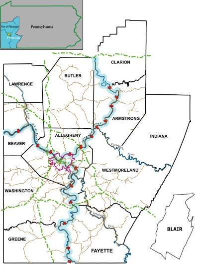
Greater Pittsburgh is the metropolitan area surrounding the city of Pittsburgh in Western Pennsylvania, United States. The region includes Allegheny County, Pittsburgh's urban core county and economic hub, and seven adjacent Pennsylvania counties: Armstrong, Beaver, Butler, Fayette, Lawrence, Washington, and Westmoreland in Western Pennsylvania, which constitutes the Pittsburgh, PA Metropolitan Statistical Area MSA as defined by the U.S. Census Bureau.

The inland waterways of the United States include more than 25,000 mi (40,000 km) of navigable waters. Much of the commercially important waterways of the United States consist of the Mississippi River System—the Mississippi River and connecting waterways.

A large metropolitan area that is surrounded by rivers and hills, Pittsburgh has an infrastructure system that has been built out over the years to include roads, tunnels, bridges, railroads, inclines, bike paths, and stairways; however, the hills and rivers still form many barriers to transportation within the city.
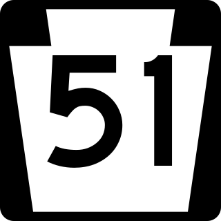
Pennsylvania Route 51 is a major state highway that is located in Western Pennsylvania in the United States. It runs for 89 miles (143 km) from Uniontown to the Ohio state line near Darlington, where it connects with Ohio State Route 14.

The geography of Pennsylvania varies from sea level marine estuary to mountainous plateau. The state is known for its natural resources, ports, and the leading role it played in the nation's founding and history.

U.S. Route 40 enters Pennsylvania at West Alexander. It closely parallels Interstate 70 (I-70) from West Virginia until it reaches Washington, where it follows Jefferson Avenue and Maiden Street. In Washington, US 40 passes to the south of Washington & Jefferson College. Following Maiden Street out of town, the road turns southeast toward the town of California. A short limited access highway in California and West Brownsville provides an approach to the Lane Bane Bridge across the Monongahela River. From here, the road continues southeast to Uniontown.

Brownsville Road is a road between Pittsburgh, at Eighteenth Street and South Avenue in Allegheny County, Pennsylvania eastwards through Mount Oliver and generally highlands situated along or near the hilltops often overlooking the Monongahela River. It has had several names over its history, and was also known at the Red Stone Road and the period it was a Plank Road managed as a toll road, the Brownsville Plank Road, or the Brownsville Turnpike, or locally, as the area grew into a city, Southern Avenue.
The Great Lakes megalopolis consists of a bi-national group of metropolitan areas in North America largely in the Great Lakes region. It extends from the Midwestern United States in the south and west to western Pennsylvania and Western New York in the east and northward through Southern Ontario into southwestern Quebec in Canada. It is the most populated and largest megalopolis in North America.

Lake Monongahela was a proglacial lake in western Pennsylvania, West Virginia, and Ohio. It formed during the Pre-Illinoian ice epoch when the retreat of the ice sheet northwards blocked the drainage of these valleys to the north. The lake formed south of the ice front continued to rise until it was able to breach a low divide near New Martinsville, West Virginia. The overflow was the beginning of the process which created the modern Ohio River valley.
