Port of Rotterdam

Last updated

Port of Rotterdam
Gem-Rotterdam-2014Q1.jpg
Port of Rotterdam logo (light-blue).svg
Port of Rotterdam
Click on the map for a fullscreen view
Location
Country Flag of the Netherlands.svg  Netherlands
Location
Coordinates 51°53′06″N4°17′12″E / 51.8850°N 4.2867°E / 51.8850; 4.2867
UN/LOCODE NL RTM [1]
Details
Opened14th century
Size of harbour4,810 ha (11,900 acres) [2]
Land area7,903 ha (19,530 acres) [2]
Size12,713 ha (31,410 acres) [2]
Employees1,270 (2021) [3]
Chief Executive OfficerAllard Castelein [4]
Chief Operating OfficerBoudewijn Siemons
Chief Financial OfficerVivienne de Leeuw [4]
Statistics
Vessel arrivalsIncrease2.svg 28,876 sea ships (2021)
Annual cargo tonnage Increase2.svg 468.7 million tonnes (2021)
Annual container volumeIncrease2.svg 15,3 million TEU (2021)
Annual revenue Increase2.svg 772.7 million (2021)
Net income Decrease2.svg 247.2 million net profit (2021)
Inland vesselsSteady2.svg 99,558 ships (2021)
Website
www.portofrotterdam.com
Aerial view Haven van Rotterdam 2023 (06).jpg
Aerial view

The Port of Rotterdam is the largest seaport in Europe, and the world's largest seaport outside of East Asia, located in and near the city of Rotterdam, in the province of South Holland in the Netherlands. From 1962 until 2004, it was the world's busiest port by annual cargo tonnage. It was overtaken first in 2004 by the port of Singapore, and since then by Shanghai and other very large Chinese seaports. In 2020, Rotterdam was the world's tenth-largest container port in terms of twenty-foot equivalent units (TEU) handled. [5] In 2017, Rotterdam was also the world's tenth-largest cargo port in terms of annual cargo tonnage. [6]

Contents

Covering 105 square kilometres (41 sq mi), the port of Rotterdam now stretches over a distance of 40 kilometres (25 mi). It consists of the city centre's historic harbour area, including Delfshaven; the Maashaven/Rijnhaven/Feijenoord complex; the harbours around Nieuw-Mathenesse; Waalhaven; Vondelingenplaat; Eemhaven; Botlek; Europoort, situated along the Calandkanaal, Nieuwe Waterweg and Scheur (the latter two being continuations of the Nieuwe Maas); and the reclaimed Maasvlakte area, which projects into the North Sea. The Port of Rotterdam is located in the middle of the Rhine-Meuse-Scheldt delta. Rotterdam has five port concessions (ports) within its boundaries - operated by separate companies under the overall authority of Rotterdam.

Rotterdam consists of five distinct port areas and three distribution parks that facilitate the needs of a hinterland with over 500,000,000 consumers throughout the continent of Europe.

Nieuwe Waterweg

In the first half of the 19th century the port activities moved from the centre westward towards the North Sea. To improve the connection to the North Sea, the Nieuwe Waterweg ("New Waterway"), a large canal, was designed to connect the Rhine and Meuse rivers to the sea. The Nieuwe Waterweg, designed by Pieter Caland, was to be partly dug, then to further deepen the canal bed by the natural flow of the water. Ultimately however, the last part had to be dug by manual labour as well. Nevertheless, Rotterdam from then on had a direct connection between the sea and harbour areas with sufficient depth. The Nieuwe Waterweg has since been deepened several times. It was ready in 1872 and all sorts of industrial activity formed on the banks of this canal.

Europoort and Maasvlakte extensions

Europoort Rotterdam and Nieuwe Waterweg Europoort Rotterdam and Nieuwe Waterweg of the Maas.jpg
Europoort Rotterdam and Nieuwe Waterweg
The Waalhaven at night Waalhaven in Rotterdam 2016.jpg
The Waalhaven at night
Satellite photography of the Port of Rotterdam Port of Rotterdam Landsat 8 Photo 8 May 2016.jpg
Satellite photography of the Port of Rotterdam
Aerial view of the Maasvlakte area, one of the latest extensions to the port Maasvlakte-europort.jpg
Aerial view of the Maasvlakte area, one of the latest extensions to the port

Over the years the port was further developed seaward by building new docks and harbour-basins. Rotterdam's harbour territory has been enlarged by the construction of the Europoort (gate to Europe) complex along the mouth of the Nieuwe Waterweg. In the 1970s the port was extended into the sea at the south side of the mouth of the Nieuwe Waterweg by completion of the Maasvlakte (Meuse-plain) which was built in the North Sea near Hook of Holland.

In the past five years the industrialised skyline has been changed by the addition of large numbers of wind turbines taking advantage of the exposed coastal conditions. The construction of a second Maasvlakte received initial political approval in 2004, but was stopped by the Raad van State (the Dutch Council of State, which advises the government and parliament on legislation and governance) in 2005, because the plans did not take enough account of environmental issues. On 10 October 2006, however, approval was acquired to start construction in 2008, aiming for the first ship to anchor in 2013.

Characteristics

Container terminals showing a container being loaded onto an unmanned automated guided vehicle 9-028 Rotterdam ECT.jpg
Container terminals showing a container being loaded onto an unmanned automated guided vehicle

Most important for the port of Rotterdam is the petrochemical industry and general cargo transshipment handlings. The harbour functions as an important transit point for transport of bulk and other goods between the European continent and other parts of the world. From Rotterdam goods are transported by ship, river barge, train or road. Since 2000 the Betuweroute , a fast cargo railway from Rotterdam to Germany, has been under construction. The Dutch part of this railway opened in 2007. Large oil refineries are located west of the city. The rivers Meuse (Maas) and Rhine also provide excellent access to the pan-European hinterland.

24-metre draft

The EECV-quay of the port has a draft of 24 metres (78 feet). [7] This made it one of only two available mooring locations for one of the largest bulk cargo ships in the world, the iron ore bulk carrier MS Berge Stahl when it is fully loaded, along with the Terminal of Ponta da Madeira in Brazil, [8] until the opening of a new deep-water iron ore wharf at Caofeidian in China in 2011. [9] The ship's draft of 23 meters (75 feet) leaves only 1 metre (3 feet) of under keel clearance, therefore it can only dock in a restricted tidal window. [10] Such ships must travel in the Eurogeul waterway.

Robotic container operations

Much of the container loading and stacking in the port is handled by autonomous robotic cranes and computer controlled chariots. Europe Container Terminals, which operates two major container terminals at the port, pioneered the development of terminal automation. At the Delta terminal, the chariots—or automated guided vehicles (AGV)—are unmanned and each carries one container. The chariots navigate their own way around the terminal with the help of a magnetic grid built into the terminal tarmac. Once a container is loaded onto an AGV, it is identified by infrared "eyes" and delivered to its designated place within the terminal. This terminal is also named "the ghost terminal". [11]

Unmanned Automated Stacking Cranes (ASC) take containers to/from the AGVs and store them in the stacking yard. The newer Euromax terminal implements an evolution of this design that eliminates the use of straddle carriers for the land-side operations.

Smart Technology

The Port Authority at the Port of Rotterdam uses the Internet of Things, a cloud-based platform, to collect and process data from sensors around the port. In May 2019, the port sent Container 42[ clarification needed ] out on a two-year data-collecting mission. [12]

Urban renewal in vacant port areas

As early as 1892, the Leuvehaven attracted the first museum visitors. Art lovers could view one of Van Gogh's first exhibitions in the art gallery at number 74 Leuvehaven. At the time, no one would have thought that the harbor itself would have become a museum a hundred years later. In 1979 the Maritime Museum opened the museum ship the Buffel in the Leuvehaven. That ship used to serve for the Dutch navy. On April 16, 1983, the Maritime Museum was built at the head of the Leuvehaven. It opened in 1986. The Maritime Museum (Havenmuseum, merged with the Maritime Museum since 2014) filled the rest of the harbor with ships. The Leuvehaven is still a home port for a small number of inland vessels.

The Oude Haven is one of the oldest ports of Rotterdam. It is located in the center of the city, south-east of Rotterdam Blaak station. Today the Oude Haven is a well-known and busy nightlife area with cafes and restaurants with terraces on the water, close to the famous Kubuswoningen, the Witte Huis and the adjacent Mariniersmuseum. Rotterdam University of Applied Sciences has a location nearby.

The most important project in this development is the Kop van Zuid - an area on the south bank of the Nieuwe Maas, directly opposite the city center. The area has not been used as a port since the German bombing in 1940 and fell into disrepair in the decades that followed. In 1993 the Hotel New York, former office building of the Holland America Lines (Nederlandsch Amerikaansche Stoomvaart Maatschappij), opened. With the construction of the Erasmusbrug in 1996, the city created a direct connection between the two banks of the Meuse. Since then, numerous public buildings such as the Luxor theater, several museums, but also office and residential high-rises have been built. In March 2020 it was announced that the Rijnhaven will be partially filled in after 2024 and used for residential construction and the construction of a city park. The Posthumalaan will then become a city boulevard with high residential towers and the Wilhelminaplein and Rijnhaven underground stations will be renovated. In the meantime, the Floating Office Rotterdam (FOR) [13] opened in September 2021 on the Antoine Platekade and accommodates the Global Center on Adaptation. The FOR also includes a restaurant and an outdoor swimming pool. This is a project in the context of the Rotterdam Climate Initiative (RCI).

Administration

The main office of the Port of Rotterdam Port of Rotterdam, 2012.jpg
The main office of the Port of Rotterdam
Raillinks and refineries in the Europoort area of the port. Europoort 01-04-2005 7.41.22.JPG
Raillinks and refineries in the Europoort area of the port.

The port is operated by the Port of Rotterdam Authority, originally a municipal body of the municipality of Rotterdam, but since 1 January 2004, a government corporation jointly owned by the municipality of Rotterdam and the Dutch State. [14]

Flood barriers

The Port of Rotterdam and its surrounding area is susceptible to a storm surge from the North Sea. As part of the Delta Works plan, the Maeslantkering flood barrier was constructed from 1991 to 1997 to protect the area. This flood barrier consists of two huge doors that normally rest in a dry dock besides the Nieuwe Waterweg. When a flood of 3 metres (9.8 ft) above NAP (mean sea level) is predicted, the barrier is activated. The dry dock is flooded, and the gates rotate around a pivot to float into position, like caissons, and sunk in place. When the water level recedes enough to open the gates, they are floated back into their docks. [15] Another barrier, the Hartelkering, is situated in the Hartelkanaal.

Sustainability

The Port of Rotterdam aims to be emissions-free by the year 2050. [16] In 2018, the Port Authority CEO launched a EUR 5 million incentive scheme for climate-friendly shipping. [17]

Map of port

Port of Rotterdam RotterdamPort.svg
Port of Rotterdam

See also

Related Research Articles

<span class="mw-page-title-main">Nieuwe Waterweg</span> Ship canal in the Netherlands

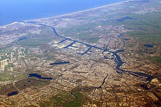
The Nieuwe Waterweg is a ship canal in the Netherlands from het Scheur west of the town of Maassluis to the North Sea at Hook of Holland: the Maasmond, where the Nieuwe Waterweg connects to the Maasgeul. It is the artificial mouth of the river Rhine.

<span class="mw-page-title-main">Port</span> Maritime facility where ships may dock to load and discharge passengers and cargo

A port is a maritime facility comprising one or more wharves or loading areas, where ships load and discharge cargo and passengers. Although usually situated on a sea coast or estuary, ports can also be found far inland, such as Hamburg, Manchester and Duluth; these access the sea via rivers or canals. Because of their roles as ports of entry for immigrants as well as soldiers in wartime, many port cities have experienced dramatic multi-ethnic and multicultural changes throughout their histories.

<span class="mw-page-title-main">Hellevoetsluis</span> City in South Holland, Netherlands

Hellevoetsluis is a small city in the western Netherlands. It is located in Voorne-Putten, South Holland. The former municipality covered an area of 61.20 km2 (23.63 sq mi) of which 20.10 km2 (7.76 sq mi) was water and it included the population centres of Nieuw-Helvoet, Nieuwenhoorn, and Oude en Nieuwe Struiten, all former municipalities.

<span class="mw-page-title-main">Rozenburg</span> Town in South Holland province of the Netherlands

Rozenburg is a town and former municipality in the western Netherlands, in the province of South Holland. The municipality had a population of 13,173 in 2004, and covers an area of 6.50 km2. It was the second-smallest municipality in the Netherlands in area. On 10 July 2008, the local council decided to disband the municipality and to form a submunicipality of Rotterdam. This was ratified on 27 October 2008 by the Eerste Kamer, and came into effect on 18 March 2010.

<span class="mw-page-title-main">Maeslantkering</span> Dutch storm surge barrier

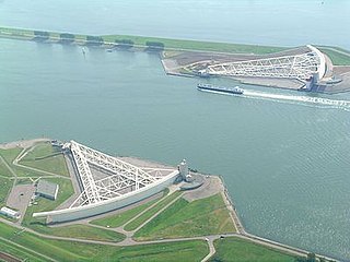
The Maeslantkering is a storm surge barrier on the Nieuwe Waterweg, in South Holland, Netherlands. It was constructed from 1991 to 1997. As part of the Delta Works the barrier responds to water level predictions calculated by a centralized computer system called BOS. It automatically closes when Rotterdam is threatened by floods.

<span class="mw-page-title-main">Europoort</span> Area of the Port of Rotterdam

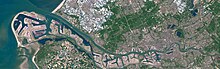
Europoort is an area of the Port of Rotterdam and the adjoining industrial area in the Netherlands. Being situated at Southside of the mouth of the rivers Rhine and Meuse with the hinterland consisting of the Netherlands, Germany, Belgium and partly France, Europoort is one of the world's busiest ports and considered a major entry to Europe. The port handled 12 million containers in 2015.

<span class="mw-page-title-main">Maasvlakte</span> Westward extension of the Europoort

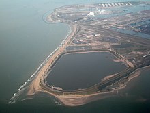
The Maasvlakte is a massive man-made westward extension of the Europoort port and industrial facility within the Port of Rotterdam. Situated in the municipality of Rotterdam in the Netherlands, the Maasvlakte is built on land reclaimed from the North Sea.

<span class="mw-page-title-main">Container port</span> Facility handling shipping containers

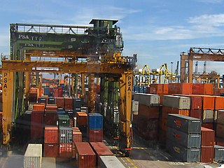
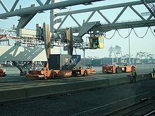
A container port or container terminal is a facility where cargo containers are transshipped between different transport vehicles, for onward transportation. The transshipment may be between container ships and land vehicles, for example trains or trucks, in which case the terminal is described as a maritime container port. Alternatively, the transshipment may be between land vehicles, typically between train and truck, in which case the terminal is described as an inland container port.

<span class="mw-page-title-main">Port of Antwerp</span> Maritime commercial facility in Antwerp, Belgium

The Port of Antwerp is the port of the city of Antwerp, Belgium. It is located in Flanders, mainly in the province of Antwerp, but also partially in East Flanders. It is a seaport in the heart of Europe accessible to capesize ships. It is Europe's second-largest seaport, after that of Rotterdam. Antwerp stands at the upper end of the tidal estuary of the Scheldt. The estuary is navigable by ships of more than 100,000 Gross Tons as far as 80 km inland. Like the Port of Hamburg, the Port of Antwerp's inland location provides a more central location in Europe than the majority of North Sea ports. Antwerp's docks are connected to the hinterland by rail, road, and river and canal waterways. As a result, the port of Antwerp has become one of Europe's largest seaports, ranking second behind Rotterdam by total freight shipped. Its international rankings vary from 11th to 20th (AAPA). In 2012, the Port of Antwerp handled 14,220 sea trade ships, 57,044 inland barges, and offered liner services to 800 different maritime destinations.

<span class="mw-page-title-main">Port of Karachi</span> Deep-water seaport in Sindh, Pakistan

The Port of Karachi is one of South Asia's largest and busiest deep-water seaports, handling about 60% of the nation's cargo located in Karachi, Pakistan. It is located on the Karachi Harbour, between Kiamari Azra Langri, Manora, and Kakapir, and close to Karachi's main business district and several industrial areas. The geographic position of the port places it in close proximity to major shipping routes such as the Strait of Hormuz. It is also ideally located to offer gateway services to the maritime trade for the Central Asian Republics (CARs). The administration of the port is carried out by the Karachi Port Trust, which was established in 1857.

<span class="mw-page-title-main">Port of Kaohsiung</span> Port in Kaohsiung, Taiwan

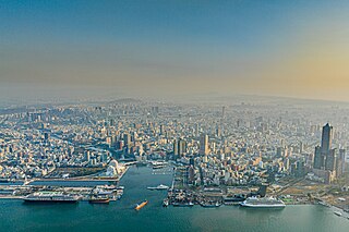
The Port of Kaohsiung is the largest harbor in Taiwan, handling approximately 10.26 million twenty-foot equivalent units (TEU) worth of cargo in 2015. The port is located in southern Taiwan, adjacent to Kaohsiung City, and surrounded by the city districts of Gushan, Yancheng, Lingya, Cianjhen, Siaogang, as well as Cijin. It is operated by Taiwan International Ports Corporation, Taiwan's state-owned harbor management company.

<span class="mw-page-title-main">Port of Tanjung Priok</span> Port in Indonesia

Port of Tanjung Priok is the busiest and most advanced Indonesian seaport, handling more than 50% of Indonesia's trans-shipment cargo traffic. The port is located at Tanjung Priok, North Jakarta, which is operated by Indonesian state owned PT Pelindo. The port loaded and unloaded 6.2 million, 6.92 million, and 7.8 million TEUs of cargo during 2016, 2017 and 2018 respectively, out of a total capacity of about 8 million TEUs. The container port ranked as 22nd busiest in the world by Lloyd's One Hundred Ports 2019.

<span class="mw-page-title-main">Port of Amsterdam</span> Port in Netherlands

The port of Amsterdam is a seaport in Amsterdam in North Holland, Netherlands. It is the 4th busiest port in Europe by metric tonnes of cargo. The port is located on the bank of a former bay named the IJ and the North Sea Canal, with which it is connected to the North Sea. The port was first used in the 13th century and was one of the main ports of the Dutch East India Company in the 17th century. Today, the port of Amsterdam is the second largest port in the Netherlands, the largest being the Port of Rotterdam. In 2014, the port of Amsterdam had a cargo throughput of 97.4 million tons, most of which was bulk cargo.

<span class="mw-page-title-main">Maasvlakte Light</span> Lighthouse

Maasvlakte Light is an inactive lighthouse in Maasvlakte, an industrial area in the city of Rotterdam, the Netherlands. At a height of 216 feet (66 m) it is the twelfth-tallest "traditional lighthouse" in the world, as well as the second-tallest concrete lighthouse in the world, and the tallest Dutch lighthouse.

<span class="mw-page-title-main">Rozenburg (island)</span> Island in South Holland province, Netherlands

Rozenburg is an island in the western Netherlands, in the province of South Holland. Rozenburg Island was formed centuries ago from several sand bars in the Meuse estuary. In 1568, construction started on the first set of dikes and in 1586 the land known as Roosenburgh was leased to Dirk Ariensz. Bisdommer and Son, the first permanent inhabitant of Rozenburg.

<span class="mw-page-title-main">Maasvlakte 2</span>

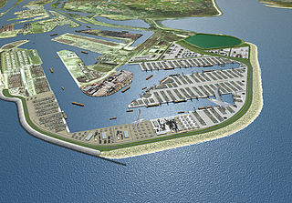
Maasvlakte 2 is a major civil engineering project in the Netherlands, constructing a new port and supporting infrastructure on reclaimed land adjoining the Maasvlakte. Approximately 2000 hectares will be reclaimed, behind a 4 km dike; approximately 1000 hectares will be used by ports related industries. It is an extension of the Port of Rotterdam.

The World Port Days, also known as the World Harbour Days, is a large, festive maritime event held annually in Rotterdam. It is one of the most highly attended events in the Netherlands.

<span class="mw-page-title-main">Muuga Harbour</span> Harbor in Estonia

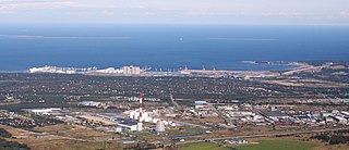
Muuga Harbour is the largest cargo port in Estonia, located on the southern coast of the Gulf of Finland, 17 kilometres (11 mi) northeast of the capital Tallinn, in Maardu. The harbour is administrated by Port of Tallinn, the biggest port authority in Estonia. Muuga Harbour is one of the few ice-free ports in northernmost Europe and among the deepest —up to 18 metres (59 ft) — and most modern ports in the Baltic Sea region. The cargo volume handled accounts for around 80% of the total cargo volume of Port of Tallinn and approximately 90% of the transit cargo volume passing through Estonia. Nearly 3/4 of cargo loaded in Muuga Harbour includes crude oil and oil products, but the harbour also serves dry bulk and other types of cargo.

<span class="mw-page-title-main">Europoortkering</span>

The Europoortkering or barrier of the Europoort is a program of engineering works in addition to the Delta Plan, designed to protect the maritime access routes from the port of Rotterdam and thus, the entire South Holland against storms and tides.

<span class="mw-page-title-main">Low Light of the Hook of Holland</span> Lighthouse

The Low Light of the Hook of Holland is a lighthouse that once stood at the Hook of Holland, but has since been dismantled and reassembled near the Rotterdam maritime museum.

References

  1. "UNLOCODE (NL) - NETHERLANDS". service.unece.org. Retrieved 25 April 2020.
  2. 1 2 3 "Port of Rotterdam. Highlights of the 2018 Annual Report". Port of Rotterdam Authority. Retrieved 16 November 2020.
  3. portofrotterdam.com
  4. 1 2 "Executive Board". Port of Rotterdam. 30 September 2020.
  5. The largest container ports worldwide by cargo throughput 2020 – Statista
  6. "The world's 10 biggest ports". ship-technology.com. Retrieved 17 March 2014.
  7. Port of Rotterdam: Iron Ore, archived from the original on 14 November 2006
  8. "Machine Support services on world's largest dry bulk carrier" Machine Support News
  9. 曹妃甸港首次接卸30万吨以上铁矿石巨轮, 31 October 2011, archived from the original on 26 April 2012
  10. RWS Noordzee: Tidal-window advice, Dutch Archived 9 October 2006 at the Wayback Machine
  11. Will Robots Take Our Jobs? - BBC Click , retrieved 30 October 2019
  12. "Port of Rotterdam: Hyper-Smart Container to Begin Round the World Trip | World Maritime News". worldmaritimenews.com. 24 May 2019. Retrieved 30 October 2019.
  13. Floating Office Rotterdam
  14. "Company Profile". Archived from the original on 5 March 2010. Retrieved 27 April 2010.
  15. Rijkswaterstaat. Maeslant Barrier Retrieved on 13 March 2022.
  16. "Duurzaamheid". portofrotterdam.com. Port of Rotterdam. Retrieved 11 January 2018.
  17. "Port of Rotterdam – Incentive scheme for climate-friendly shipping". sustainableworldports.org. Sustainable Wordl Ports. Retrieved 14 May 2023.