
Portland Head Light is a historic lighthouse in Cape Elizabeth, Maine. The light station sits on a head of land at the entrance of the primary shipping channel into Portland Harbor, which is within Casco Bay in the Gulf of Maine. Completed in 1791, it is the oldest lighthouse in Maine. The light station is automated, and the tower, beacon, and foghorn are maintained by the United States Coast Guard, while the former lighthouse keepers' house is a maritime museum within Fort Williams Park.
Mather Tower is a Neo-Gothic, terra cotta-clad high-rise structure in Chicago, Illinois, United States. It is located at 75 East Wacker Drive in the downtown "loop" area, adjacent to the Chicago River.
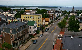
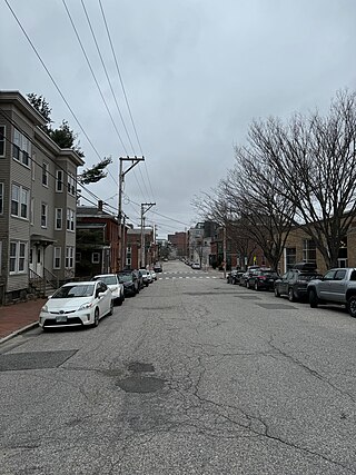
Munjoy Hill is both a neighborhood and prominent geographical feature of Portland, Maine. It is located east of downtown and south of East Deering, the neighborhood it is connected to by Tukey's Bridge. The neighborhood historically had a large Irish and Italian American population.

The University of Illinois Astronomical Observatory, located at 901 S. Mathews Avenue in Urbana, Illinois, on the campus of the University of Illinois Urbana–Champaign, was built in 1896, and was designed by Charles A. Gunn. It was listed on the National Register of Historic Places on November 6, 1986, and on December 20, 1989, was designated a National Historic Landmark.
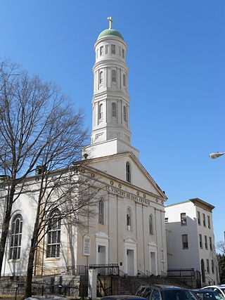
St. Vincent de Paul Church is a historic Roman Catholic church located within the Archdiocese of Baltimore at 120 N. Front Street, Baltimore, Maryland, United States.

The History of Portland, Maine, begins when Native Americans originally called the Portland peninsula Məkíhkanək meaning "At the fish hook" in Penobscot and Machigonne in Algonquian. The peninsula and surrounding areas was home to members of the Algonquian-speaking Aucocisco branch of the Eastern Abenaki tribe who were forcibly relocated to current day Canada during European settlement.

Eastern Cemetery is a historic cemetery at the intersection of Washington Avenue and Congress Street in the Munjoy Hill neighborhood of Portland, Maine. Established in 1668, it is the city's oldest historic site. It has more than 4,000 marked graves with an estimated further 3,000 burials in unmarked plots. It was listed on the National Register of Historic Places in 1973.

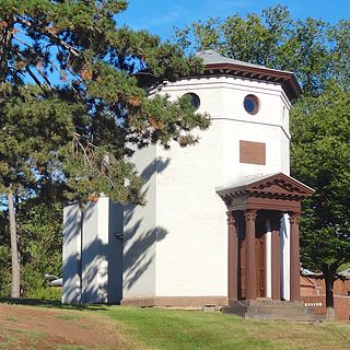
The Hill Arts or St. Lawrence Arts Center is a performing arts center and community space at 76 Congress Street in the Munjoy Hill district of Portland, Maine. It is located in the former parish hall of the former St. Lawrence Church, a historic Romanesque church that was built in 1897. In 2008, due to severe deterioration, the sanctuary of the former church was razed and the organization began planning to create a performance arts space where the sanctuary stood. The church property was listed on the National Register of Historic Places in 1979.
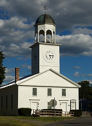
The Union Church, now Phillips Congregational Church, is a historic church on Main and Pleasant Streets in Phillips, Maine. Built in 1835, this Greek Revival church is the oldest religious building in the small community, and a distinctive local landmark. It was listed on the National Register of Historic Places in 1989.

The Samuel May Williams House is a former museum in Galveston, Texas. The second-oldest surviving residence in Galveston, it is now on the National Register of Historic Places. It was designated a Recorded Texas Historic Landmark in 1964.
Portland, Maine, is home to many neighborhoods.
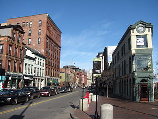
Congress Street is the main street in Portland, Maine. Around 5.77 miles (9.29 km) long, it stretches from County Road, Portland's southwestern border with Westbrook, through a number of neighborhoods, before ending overlooking the Eastern Promenade on Munjoy Hill. In March 2009, the Portland City Council designated much of the inner portion of Congress Street a historic district. The western section of the street includes the city's Arts District.
The following is a timeline of the history of the city of Portland, Maine, USA.
The Daniel S. Schanck Observatory is an historical astronomical observatory on the Queens Campus of Rutgers University in New Brunswick, New Jersey, United States, and is tied for the seventh oldest observatory in the US alongside the Vassar College Observatory. It is located on George Street near the corner with Hamilton Street, opposite the parking lot adjacent to Kirkpatrick Chapel, and to the northeast of Old Queens and Geology Hall.
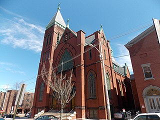
St. Dominic's Church is an historic Catholic church building in Portland, Maine, located at the corner of Gray Street and State Street. When it was dedicated on August 11, 1833, it became the first Roman Catholic church in the city and the third in the state. Parishioners generally resided in the historically Irish neighborhoods of Gorham's Corner, Munjoy Hill (Portland) and Knightville. Prior to the closing of the parish in 1997, it had been at one time one of the largest Irish-American Catholic parishes north of Boston. In 2003, the building was transferred to the newly formed Maine Irish Heritage Center.

Sacred Heart Church is an historic church building in Portland, Maine, owned by the Roman Catholic Diocese of Portland.

Fore Street is a downtown street in Portland, Maine, United States. Dating to 1724, it runs for around 1 mile (1.6 km), from the Eastern Promenade on Munjoy Hill in the northeast to Pleasant Street in the southwest. Near its midsection, Fore Street crosses Franklin Street. It splits briefly at Boothby Square, shortly after passing the United States Custom House. The street passes through the Old Port district.

India Street is a downtown street and neighborhood in Portland, Maine, United States. Situated near the western foot of Munjoy Hill, it runs for around 0.28 miles (0.45 km), from Congress Street in the northwest to Commercial Street and Thames Street in the southeast. It was the city's first street, and the location of the first settlement of European immigrants to the city in the 17th century. There are thirty handmade bricks in the sidewalk commemorating the neighborhood's notable events. In 1680, when Thomas Danforth was Deputy Governor of the Massachusetts Bay Colony, the street was known as Broad Street. After the incorporation of the Town of Falmouth in 1718, the street was known as High King Street.
Federal Street is a historic downtown street in Portland, Maine, United States. It runs for around 0.56 miles (0.90 km), from Monument Way, in Monument Square, in the southwest to Mountfort Street, at the foot of Munjoy Hill, in the northeast. Its middle section was wiped out by the widening of Franklin Street in 1967.

Mountfort Street is a historic downtown street in Portland, Maine, United States. It runs for around 0.22 miles (0.35 km), from Congress Street, at the foot of Munjoy Hill, in the northwest to Fore Street in the southeast. It forms the eastern boundary of Eastern Cemetery, which was established in 1668.


