
The Mississippi River is the second-longest river and chief river of the second-largest drainage system on the North American continent, second only to the Hudson Bay drainage system. From its traditional source of Lake Itasca in northern Minnesota, it flows generally south for 2,340 miles (3,770 km) to the Mississippi River Delta in the Gulf of Mexico. With its many tributaries, the Mississippi's watershed drains all or parts of 32 U.S. states and two Canadian provinces between the Rocky and Appalachian mountains. The main stem is entirely within the United States; the total drainage basin is 1,151,000 sq mi (2,980,000 km2), of which only about one percent is in Canada. The Mississippi ranks as the thirteenth-largest river by discharge in the world. The river either borders or passes through the states of Minnesota, Wisconsin, Iowa, Illinois, Missouri, Kentucky, Tennessee, Arkansas, Mississippi, and Louisiana.
North Dakota is a U.S. state in the Upper Midwest, named after the indigenous Dakota Sioux. North Dakota is bordered by the Canadian provinces of Saskatchewan and Manitoba to the north and by the U.S. states of Minnesota to the east, South Dakota to the south, and Montana to the west. It is believed to host the geographic center of North America, Rugby, and is home to the tallest man-made structure in the Western Hemisphere, the KVLY-TV mast.

Itasca County is located in the State of Minnesota. As of the 2020 census, the population was 45,014. Its county seat is Grand Rapids. The county is named after Lake Itasca, which is in turn a shortened version of the Latin words veritas caput, meaning 'truth' and 'head', a reference to the source of the Mississippi River. Portions of the Bois Forte and Leech Lake Indian reservations are in the county.
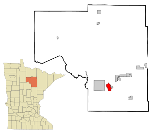
Grand Rapids is a city in and the county seat of Itasca County, Minnesota, United States. The population was 10,869 at the 2010 census. The city is named for the 3.5-mile (5.6 km) long local rapids in the Mississippi River, which was the uppermost limit of practical steamboat travel during the late 19th century. Today the rapids are hidden below the dam of the Blandin Paper Mill.
Koch Industries, Inc. is an American privately held multinational conglomerate corporation based in Wichita, Kansas. Its subsidiaries are involved in the manufacturing, refining, and distribution of petroleum, chemicals, energy, fiber, intermediates and polymers, minerals, fertilizers, pulp and paper, chemical technology equipment, ranching, finance, trade of raw materials and other consumable products, and investing. Koch owns Infor, Invista, Georgia-Pacific, Molex, Flint Hills Resources, Koch Pipeline, Koch Fertilizer, Koch Minerals, Matador Cattle Company, i360, and Guardian Industries. The firm employs 120,000 people in 60 countries, with about half of its business in the United States. The company is the largest non-Canadian landowner in the Athabasca oil sands.

The Yellowstone River is a tributary of the Missouri River, approximately 692 miles (1,114 km) long, in the Western United States. Considered the principal tributary of upper Missouri, via its tributaries, it drains an area with headwaters across the mountains and high plains of southern Montana and northern Wyoming, and stretching east from the Rocky Mountains in the vicinity of Yellowstone National Park. It flows northeast to its confluence with the Missouri River on the North Dakota side of the border, about 25 miles west of present-day Williston.
Enbridge Inc. is a multinational pipeline company headquartered in Calgary, Alberta, Canada. Over time, it has continued to grow through the acquisition of other existing pipeline companies and the expansion of their projects. It owns and operates pipelines throughout Canada and the United States, transporting crude oil, natural gas, and natural gas liquids. Enbridge's expansive pipeline system is the longest in North America. Its crude oil system consists of 27,500 kilometres of pipelines in Canada and the United States. Its 38,300 kilometre natural gas pipeline system connects across multiple Canadian provinces, throughout several US states, and offshore in the Gulf of Mexico.
The Enbridge Pipeline System is an oil pipeline system which transports crude oil and dilbit from Canada to the United States. The system exceeds 5,000 kilometres (3,100 mi) in length including multiple paths. More than 3,000 kilometres (1,900 mi) of the system is in the United States while the rest is in Canada and serves the Athabasca oil sands production facilities. Main parts of the system are 2,306-kilometre-long (1,433 mi) Canadian Mainline and 3,057-kilometre-long (1,900 mi) Lakehead System. On average, it delivers 1.4 million barrels per day of crude oil and other products to the major oil refineries in the American Midwest and the Canadian province of Ontario. The Canadian portion is owned by Enbridge, while the U.S. portion is partly owned by that company through Enbridge Energy Partners, LP, formerly known as Lakehead Pipe Line Partners and Lakehead Pipe Line Company.
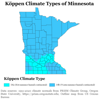
Minnesota has a humid continental climate, with hot summers and cold winters. Minnesota's location in the Upper Midwest allows it to experience some of the widest variety of weather in the United States, with each of the four seasons having its own distinct characteristics. The area near Lake Superior in the Minnesota Arrowhead region experiences weather unique from the rest of the state. The moderating effect of Lake Superior keeps the surrounding area relatively cooler in the summer and warmer in the winter, giving that region a smaller yearly temperature variation. On the Köppen climate classification, much of the southern third of Minnesota—roughly from the Twin Cities region southward—falls in the hot summer zone (Dfa), and the northern two-thirds of Minnesota falls in the warm summer zone (Dfb).

Wisconsin, a state in the Midwestern United States, has a vast and diverse geography famous for its landforms created by glaciers during the Wisconsin glaciation 17 thousand years ago. The state can be generally divided into five geographic regions—Lake Superior Lowland, Northern Highland, Central Plain, Eastern Ridges & Lowlands, and Western Upland. The southwestern part of the state, which was not covered by glaciers during the most recent ice age, is known as the Driftless Area. The Wisconsin glaciation formed the Wisconsin Dells, Devil's Lake, and the Baraboo Range. A number of areas are protected in the state, including Devil's Lake State Park, the Apostle Islands National Lakeshore, and the Chequamegon–Nicolet National Forest.

Iowa is a state in the Midwestern region of the United States, bordered by the Mississippi River to the east and the Missouri River and Big Sioux River to the west. It is bordered by six states: Wisconsin to the northeast, Illinois to the east and southeast, Missouri to the south, Nebraska to the west, South Dakota to the northwest, and Minnesota to the north.

The Kalamazoo River oil spill occurred in July 2010 when a pipeline operated by Enbridge burst and flowed into Talmadge Creek, a tributary of the Kalamazoo River. A 6-foot (1.8 m) break in the pipeline resulted in one of the largest inland oil spills in U.S. history. The pipeline carries diluted bitumen (dilbit), a heavy crude oil from Canada's Athabasca oil sands to the United States. Cleanup took five years. Following the spill, the volatile hydrocarbon diluents evaporated, leaving the heavier bitumen to sink in the water column. Thirty-five miles (56 km) of the Kalamazoo River were closed for clean-up until June 2012, when portions of the river were re-opened. On March 14, 2013, the Environmental Protection Agency (EPA) ordered Enbridge to return to dredge portions of the river to remove submerged oil and oil-contaminated sediment.
The Line 3 pipeline is an oil pipeline owned by the Canadian multinational Enbridge. Operating since 1968, it runs 1,031 miles (1,659 km) from Hardisty, Alberta, Canada to Superior, Wisconsin, United States.
The Line 3 oil spill was a 1.7 million gallon crude oil spill in Minnesota on March 3, 1991. The Line 3 pipeline, then owned by the Lakehead Pipeline Company, ruptured on a wetland near Grand Rapids, Minnesota, spilling oil into the Prairie River, a tributary of the Mississippi River. It was the largest inland oil spill in the history of the United States.

The Stop Line 3 protests are an ongoing series of demonstrations in the U.S. state of Minnesota against the expansion of Enbridge's Line 3 oil pipeline along a new route. Indigenous and two-spirit people have led the resistance to the construction of the pipeline, which began following the project's approval in November 2020. Opponents of the pipeline expansion, called water protectors, have established ceremonial lodges and resistance camps along the route of the pipeline. Enbridge has funded an escrow account that law enforcement agencies may draw on for pipeline-related police work. Organizers have arranged marches and occupations of Enbridge construction sites. Following the blockade of an Enbridge pump station on June 7, 2021, nearly 250 people were arrested. Invoking treaty rights, organizers established an encampment at the headwaters of the Mississippi River at a site where Enbridge intends to bury the pipeline.
