Durham, is a cathedral city and civil parish on the River Wear, County Durham, England. It is an administrative centre of the County Durham District, which is a successor to the historic County Palatine of Durham.
The River Hull is a navigable river in the East Riding of Yorkshire in Northern England. It rises from a series of springs to the west of Driffield, and enters the Humber Estuary at Kingston upon Hull. Following a period when the Archbishops of York charged tolls for its use, it became a free navigation. The upper reaches became part of the Driffield Navigation from 1770, after which they were again subject to tolls, and the section within the city of Hull came under the jurisdiction of the Port of Hull, with the same result.

The Cathedral Church of Christ, Blessed Mary the Virgin and St Cuthbert of Durham, commonly known as Durham Cathedral and home of the Shrine of St Cuthbert, is a cathedral in the city of Durham, County Durham, England. It is the seat of the Bishop of Durham, the fourth-ranked bishop in the Church of England hierarchy.

Sunderland is a port city in Tyne and Wear, England. It is the City of Sunderland's administrative centre and in the historic county of Durham. The city is 10 miles (16 km) from Newcastle-upon-Tyne and is on the River Wear's mouth to the North Sea. The river also flows through Durham roughly 12 miles (19 km) south-west of Sunderland City Centre. It is the only other city in the county and the second largest settlement in the North East after Newcastle upon Tyne.

Castlefield is an inner-city conservation area in Manchester, North West England. The conservation area which bears its name is bounded by the River Irwell, Quay Street, Deansgate and Chester Road. It was the site of the Roman era fort of Mamucium or Mancunium which gave its name to Manchester. It was the terminus of the Bridgewater Canal, the world's first industrial canal, built in 1764; the oldest canal warehouse opened in 1779. The world's first passenger railway terminated here in 1830, at Liverpool Road railway station and the first railway warehouse opened here in 1831.

Matlock is the county town of Derbyshire, England. It is in the south-eastern part of the Peak District, with the National Park directly to the west. The town is twinned with the French town of Eaubonne. The former spa resort of Matlock Bath lies immediately south of the town on the A6. The civil parish of Matlock Town had a population in the 2011 UK census of 9,543.

A pontoon bridge, also known as a floating bridge, uses floats or shallow-draft boats to support a continuous deck for pedestrian and vehicle travel. The buoyancy of the supports limits the maximum load that they can carry.
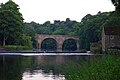
Sunderland Bridge is a bridge just outside the village also called Sunderland Bridge in County Durham, England. It lies close to the confluence of the River Wear and River Browney.

A footbridge is a bridge designed solely for pedestrians. While the primary meaning for a bridge is a structure which links "two points at a height above the ground", a footbridge can also be a lower structure, such as a boardwalk, that enables pedestrians to cross wet, fragile, or marshy land. Bridges range from stepping stones–possibly the earliest man-made structure to "bridge" water–to elaborate steel structures. Another early bridge would have been simply a fallen tree. In some cases a footbridge can be both functional and artistic.

The Bailey, or The Peninsula, is a historic area in the centre of Durham, England. It is a peninsula within a sharp meander in the River Wear, formed by isostatic adjustment of the land. The name 'The Bailey' derives from it being the 'outer bailey' of the Norman motte and bailey-style Durham Castle. Access to the area is restricted by the Durham City congestion charge, which started in 2002 and is the UK's oldest such scheme.

St Austell station is a Grade II listed station which serves the town of St Austell, Cornwall, England. It is 286 miles (460 km) from London Paddington via Bristol Temple Meads. The station is operated by Great Western Railway, as is every other station in Cornwall.
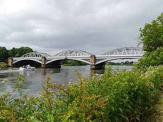
Barnes Railway Bridge is a Grade II listed railway bridge in the London Borough of Richmond upon Thames and the London Borough of Hounslow. It crosses the River Thames in London in a northwest to southeast direction at Barnes. It carries the South Western Railway's Hounslow Loop Line, and lies between Barnes Bridge and Chiswick stations. It can also be crossed on foot, and is one of only three bridges in London to combine pedestrian and rail use; the others being Hungerford Bridge and Golden Jubilee Bridges and Fulham Railway Bridge.
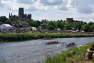
Durham Regatta is a rowing regatta held annually on the second weekend in June on the River Wear in Durham, North East of England; It is known as the Henley of the North, but began several years before the more prestigious Henley Royal Regatta. Durham Regatta is the second-oldest rowing regatta in England, preceded only by Chester Regatta. The first regatta was held over 17–19 June 1834, opening with a six-oared race in 1834 won by Velocity, owned by W. L. Wharton, High Sheriff of Durham, against the Durham University Original Club in Sylph.

The River Wey Navigation and Godalming Navigation together provide a 20-mile (32 km) continuous navigable route from the River Thames near Weybridge via Guildford to Godalming. Both waterways are in Surrey and are owned by the National Trust. The River Wey Navigation connects to the Basingstoke Canal at West Byfleet, and the Godalming Navigation to the Wey and Arun Canal near Shalford. The Navigations consist of both man-made canal cuts and adapted parts of the River Wey.
David Rowell & Co. was a company based in Westminster, London that fabricated wrought iron and wire rope, built suspension footbridges, and structural steel frame buildings. They were established in 1855 and closed in 1970.

The River Wear in North East England rises in the Pennines and flows eastwards, mostly through County Durham, to the North Sea in the City of Sunderland. At 60 mi (97 km) long, it is one of the region's longest rivers. The Wear wends in a steep valley through the cathedral city of Durham and gives its name to Weardale in its upper reach and Wearside by its mouth.
Albert Bridge is a Grade II listed skew arch bridge in Greater Manchester, England. A replacement for an earlier structure, New Bailey Bridge, it was completed in 1844. It crosses the River Irwell, connecting Salford to Manchester.
South Street is an affluent residential street in Durham, England, on the banks of the River Wear. It overlooks the Durham Cathedral, a UNESCO World Heritage Site, and Durham Castle. It is best known for its terraced houses, many of which are Grade II listed buildings built in the Tudor Revival architecture and architecture of the modern era.

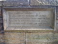
The Great Flood of 1771 affected several rivers, including the Tyne, Tees, Wear and Eden and settlements across northern England from 16 and 17 November 1771. Its cause was a sudden thaw of the ice in upper Teesdale, a cloud burst over the Pennines and a continuous period of rain.