Preobrazhensky Bridge

Last updated
Preobrazhensky Bridge

Мости Преображенського
Polit nad Dniprom.jpg
Coordinates 47°30′15″N35°03′00″E / 47.5042°N 35.0500°E / 47.5042; 35.0500
CarriesAutomobiles and Railway
Crosses Dnieper River
Locale Zaporizhzhia, Ukraine
Characteristics
DesignArched Bridge
MaterialConcrete
Total length560 metres (1,840 ft) and 228 metres (748 ft)
Width15 metres (49 ft)
Height54 metres (177 ft)
Clearance below 54 metres (177 ft)
No. of lanes 2
History
Engineering design byBorys Preobrazhenskyi
Constructed by Ukrainian SSR
Construction start1949
OpenedDecember 31, 1952
Location
Preobrazhensky Bridge

The Preobrazhensky Bridge is a two bridge crossing over the Dnipro River in the city of Zaporizhzhia, Ukraine. Construction on the bridges began in the spring of 1949 and was completed in 1952. The official opening took place on December 31, 1952. [1] Due to the lack of high-tech steel in the early post-war years, the bridges were built from reinforced concrete. The bridges are named after the engineer Borys Preobrazhenskyi. The railway and highway which run over the bridge connect the Khortytskyi District with the Zaporizhzhia city center. [2]

Contents

History

On January 3, 1944, construction of temporary post-war bridges began in Zaporizhzhia. Shortly after the expulsion of the Germans from the territory of Khortytsia and the right bank, construction of temporary bridge crossings began which allowed for railway service between Zaporizhzhia and Nikopol while permanent bridges were constructed.

Embankments were built on the left and right banks and on the island of Khortytsia to facilitate the construction of both temporary and permanent bridges. During this time, 14 km of railway track was laid, and temporary bridges with a total length of 1,886 meters were built across both channels of the Dnieper. Before the start of construction, 10,000 mines laid on Khortytsia were defused by sappers.

Construction of the permanent embankment on Khortytsia Island was conducted manually. The southern part of the dam was connected to a wooden bridge across the flood channels and the Dnipro, the length of this bridge was 1,330 meters. More than 1,500 piles alone were driven to support the wooden bridge. The supports of the temporary bridge were made of sleepers and logs impregnated with a special composition. Wooden trusses were attached to them, a floor made of beams was laid on top and railway tracks were laid. The second bridge, which connected the western part of the embankment on Khortytsia Island with the right bank, was 556 meters long and was built in just 12 days. The construction of the bridges over the Dnieper was completed on February 20, 1944, and on February 23, 1944, the first train crossed both bridges thus restoring connection between the east and west banks of the Dnieper.

These temporary bridges served Zaporizhzhia for almost 9 years. They were dismantled in December 1952 upon the completion and opening of the new Preobrazhensky Bridge. [3]

The Preobrazhensky Bridge and neighboring New Zaporizhzhia Dniper Bridge pictured in 2016 Chotiriarkovii mist Preobrazhens'kogo i novii mist, shcho buduiet'sia (foto Anatoliy Volkov, 2016).jpg
The Preobrazhensky Bridge and neighboring New Zaporizhzhia Dniper Bridge pictured in 2016

Architecture

Preobrazhensky Bridge I is four-arch double-decker bridge across the new channel of the Dnieper. The length of the bridge is 560 meters, the height is 54 meters. Preobrazhensky II is a single-arch two-story bridge across the old channel of the Dnieper. The length of the bridge is 228 meters. The bridge was the longest arch bridge in Ukraine until the construction of the Zaporizhzhia Arch Bridge in 1974. Bridge vaults on both structures are designed for the joint impact of railway and motor vehicle loads. The combination of arch structures with verticals of powerful reinforced concrete supports plays an important role in the aesthetic appearance of bridges which are considered a landmark in Zaporizhzhia.

Modern Operation

The Preobrazhensky bridges were primarily built as a road and railway crossing across the Dniper and were supposed to connect Kryvyi Rih with Donbas. At that time of their construction, cars were not as prominent in Ukraine, so bridges were built with one lane of traffic in either direction. However, over the past seventy years, a large residential population in the Khortytskyi District materialized, part of larger regional population growth that defined the post-war years in Zaporizhzhia. Due to the increases in traffic and freight loads, conditions on both of the bridges deteriorated. Both bridges are struggling with issues related to waterproofing and expansion joints deterioration. [4] Due to their narrow configuration, the bridges are consistently congested and experience long lines of traffic at either end waiting to conduct their crossing. Roadways connecting the bridge to Zaporizhzhia city center and Khortytskyi District were informally designed, poorly maintained and are prone to crashes. [5]

Deteriorating conditions on the bridge paired with issues related to traffic congestion triggered the design and construction of a new and modern bridge with significantly greater vehicular capacity directly to the south of the existing bridges. New Zaporizhzhia Dniper Bridge is a twin-span suspension bridge that began construction in 2004 and has been plagued with delays. The first deck of the bridge opened for public use in 2022. When completed, the New Zaporizhzhia Dniper Bridge will have 9 km of modern closed access highway connecting the center of Zaporizhzhia and Khortytskyi District and in doing so significantly reduce reliance on the aging Preobrazhensky Bridges and travel times between the districts.

Russian-Ukrainian War

On April 21, 2022, during the Russian invasion of Ukraine (2022) Russian cruise missiles fell on Khortytsia Island near the bridge. At that time, a train with evacuees leaving Zaporizhzhia for Lviv was traveling on the bridge. Windows on the train were blown out as a result of the strike. [6] Later that same day, the Russians struck the area with a second missile, which also hit Khortytsia Island. As a result, 8 citizens on the island were injured. The regional military-civilian administration reported that "the enemy once again tried to damage the infrastructure of the city of Zaporizhzhia by means of rocket attacks." It is believed that the bridge was the intended target of Russian forces fighting in Ukraine. [6]

Related Research Articles

<span class="mw-page-title-main">Zaporozhian Sich</span> 16th to 18th-century Cossack polity in modern southern Ukraine

The Zaporozhian Sich was a semi-autonomous polity and proto-state of Cossacks that existed between the 16th to 18th centuries, including as an autonomous stratocratic state within the Cossack Hetmanate for over a hundred years, centred around the region now home to the Kakhovka Reservoir and spanning the lower Dnieper river in Ukraine. In different periods the area came under the sovereignty of the Polish–Lithuanian Commonwealth, the Ottoman Empire, the Tsardom of Russia, and the Russian Empire.

<span class="mw-page-title-main">Zaporizhzhia</span> City and administrative centre of Zaporizhzhia Oblast, Ukraine

Zaporizhzhia or Zaporozhye, until 1921 known as Aleksandrovsk or Oleksandrivsk, is a city in southeast Ukraine, situated on the banks of the Dnieper River. It is the administrative centre of Zaporizhzhia Oblast. Zaporizhzhia has a population of 710,052.

<span class="mw-page-title-main">Dnieper Hydroelectric Station</span> Hydroelectric station in Zaporizhzhia, Ukraine

The Dnieper Hydroelectric Station, also known as Dnipro Dam, in the city of Zaporizhzhia, Ukraine, is the largest hydroelectric power station on the Dnieper river. It is the fifth step of the Dnieper cascade of hydroelectric stations that provides electric power for the Donets–Kryvyi Rih Industrial region. The Dnieper Reservoir stretches 129 kilometres (80 mi) upstream to near Dnipro city.

Khortytsia is the largest island on the Dnieper river, and is 12.5 km (7.77 mi) long and up to 2.5 km (1.55 mi) wide. The island forms part of the Khortytsia National Park. This historic site is located within the city limits of Zaporizhzhia, Ukraine.

<span class="mw-page-title-main">Bridges in Kyiv</span>

Kyiv, historically situated on the right bank of the Dnieper River, now covers both banks of the river whose width, as it flows through the city, reaches several hundred metres. Additionally, several tributaries join the Dnieper inside or just north or south of the historic city. Currently there are eight bridges spanning across the river and a few dozen bridges across the canals and Dnieper tributaries.

<span class="mw-page-title-main">Zaporizhzhia International Airport</span> Airport in Zaporizhzhia Oblast, Ukraine

Zaporizhzhia International Airport is the international airport that serves Zaporizhzhia, Ukraine, one of three airfields around the city. The aircraft engine factory Motor Sich has its base here. In May 2020, the airport was extended with a new terminal with a capacity of 400 passengers. The airport is also home to the Zaporizhzhia State Aircraft Repair Plant (ZDARZ).

<span class="mw-page-title-main">Crimean Bridge</span> Bridge to Crimea across the Kerch Strait

The Crimean Bridge, also called Kerch Strait Bridge or Kerch Bridge, is a pair of parallel bridges, one for a four-lane road and one for a double-track railway, spanning the Kerch Strait between the Taman Peninsula of Krasnodar Krai in Russia and the Kerch Peninsula of Crimea. Built by the Russian Federation after the annexation of Crimea at the start of 2014, the bridge cost ₽227.92 billion (US$3.7 billion) and has a length of 19 km (12 mi), making it the longest bridge in Europe and the longest bridge ever constructed by Russia.

<span class="mw-page-title-main">Zaporizhzhia Pylon Triple</span>

The Zaporizhzhia Pylon Triple is a set of two triples of 74.5 metres (244 ft) tall electricity pylons extending over the Dnieper river standing on a 27m rock in Zaporizhzhia, Ukraine. They are used for the transport of electricity generated at the Dnieper Hydroelectric Station over a span of 900 metres from Khortytsia island to the east bank of the Dnieper. The two triples are an unofficial landmark of Zaporizhzhia.

<span class="mw-page-title-main">Kyiv Metro Bridge</span> Bridge in Ukraine

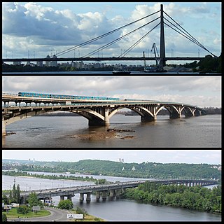
The Metro Bridge is the first metro bridge part of the Brovarsky prospect spanning across the Dnipro River in Kyiv, the capital of Ukraine. It was engineered by G. Fuks and Y. Inosov and constructed in 1965 with the expansion of the Kyiv Metro system. The bridge is used for both the Sviatoshynsko-Brovarska Line of the metro and for automobile traffic.

<span class="mw-page-title-main">Podilskyi Bridge</span> Bridge in Kyiv, Ukraine

The Podilskyi Bridge, also known as Podilsko-Voskresenskyi Bridge, is a combined road-rail bridge over the Dnipro River under construction in Kyiv, Ukraine. It is a focal point of construction of the Podilsko-Vyhurivska Line of the Kyiv Metro.

<span class="mw-page-title-main">Khortytskyi District</span> City district of Zaporizhzhia, Ukraine

The Khortytskyi District is one of seven administrative urban districts (raions) of the city of Zaporizhzhia, located in southern Ukraine. Its population was 122,575 in the 2001 Ukrainian Census, and 117,871 as of 2012.

<span class="mw-page-title-main">Zaporizhzhia Arch Bridge</span> Bridge in Zaporizhzhia, Ukraine

Zaporizhzhia Arch Bridge is the longest arch bridge in Ukraine. The bridge connects the west bank area of Zaporizhzhia with the north side of Khortytsia Island by spanning the smaller eastern branch of the River Dnieper.

<span class="mw-page-title-main">Kaidatsky Bridge</span> Bridge in Dnipro, Ukraine

Kaidatsky BridgeKaidaky Bridge is a bridge over Dnieper in the city of Dnipro, Ukraine. The bridge connects right and left banks of Dnipro and is part of the European route E50.

<span class="mw-page-title-main">New Zaporizhzhia Dniper Bridge</span> Bridge in Zaporizhzhia, Ukraine

The New Zaporizhzhia Dniper Bridge is an under-construction controlled-access highway bridge in Zaporizhzhia, Ukraine. Construction of the bridge began in August 2004 with the first span of the bridge opened for public vehicular use in January 2022 after several years of delays. The bridge was opened in a public ceremony on January 22, 2022, by President Volodymyr Zelensky. When completed, the bridge will stand at a height of 151 meters, making it the tallest in Ukraine and the eighth tallest in Europe.

Following the Russian invasion of Ukraine on 24 February 2022, the Ukrainian city of Zaporizhzhia and the surrounding region became the target of repeated Russian shelling and bombing as part of the southern Ukraine offensive from 27 February 2022 onwards. Was 30-40% infrastructure from city is destroyed.

The history of Zaporizhzhia shows the origins of Zaporizhzhia, a city located in modern day Ukraine.

<span class="mw-page-title-main">Sobornyi Avenue</span> Street in Zaporizhzhia, Ukraine

Sobornyi Avenue is the central thoroughfare of the city of Zaporizhzhia. It starts from Pryvokzalna Square near the Zaporizhzhia-1 railway station and ends at Zaporizhzhia Square near the Dnieper Hydroelectric Station. It runs along four city districts of Komunarskyi, Oleksandrivskyi, Voznesenivskyi and Dniprovskyi.

<span class="mw-page-title-main">Voznesenskyi District</span> City district of Zaporizhzhia, Ukraine

Voznesenskyi District is an administrative-territorial unit within the city of Zaporizhzhia, Ukraine named after the historical village of Voznesenky. The economic and symbolic center of the city and the Zaporizhzhia metropolitan area, it is Zaporizhzhia's oldest district and home to many of region's cultural, financial, educational and historical landmarks including Zaporizhia Regional Administration, Krytyy Market and Festival Square. The district was formed on January 21, 1939, under the name Ordzhonikidzevskyi in honor of Sergo Ordzhonikidze. It received its current name on February 19, 2016, by decree of the Ukrainian Government.

<span class="mw-page-title-main">Zaporizhzhia Tram</span> Mainline route in Ukraine

The Zaporizhzhia Tram is a tram network in the city of Zaporizhzhia, Ukraine. The network comprises 7 routes spanning 157.9 km of which 99.345 km are in use. The tram began operating on July 17, 1932. Service on the system has been interrupted but continued operating through the Russian Invasion of Ukraine 2022. The system carried 100,500 daily riders as of 2020.

References

  1. [ dead link ]
  2. "Регіональна філія 'Придніпровська залізниця' АТ 'Укрзалізниця'". Dp.uz.gov.ua. 2018-09-14. Retrieved 2023-03-01.
  3. "День в истории: 3 января в Запорожье начали строить два моста | Перший Запорiзький". 1news.zp.ua. Retrieved 2023-03-01.
  4. "Журналисты провели ревизию моста Преображенского и были повергнуты в ужас (ФОТО) - Новости Запорожья". Golos.zp.ua. 2018-04-06. Retrieved 2023-03-01.
  5. https://www.inform.zp.ua/ru/2021/10/22/129341_k-podvodnomu-obsledovaniyu-mosta-v-zaporozhe-privlekut-vodolazov/
  6. 1 2 "Ракетний удар по Запоріжжю. Що відомо - BBC News Україна". Bbc.com. 2023-02-20. Retrieved 2023-03-01.