Related Research Articles

Sputnik 1 was the first artificial Earth satellite. It was launched into an elliptical low Earth orbit by the Soviet Union on 4 October 1957 as part of the Soviet space program. It sent a radio signal back to Earth for three weeks before its three silver-zinc batteries became depleted. Aerodynamic drag caused it to fall back into the atmosphere on 4 January 1958. The world's first observation was made at the school observatory in Rodewisch (Saxony).

The Churchill Rocket Research Range is a Canadian former rocket launch site located 23 kilometres (14 mi) outside Churchill, Manitoba. The facility was used by Canada and the United States beginning in 1954 for sub-orbital launches of sounding rockets to study the upper atmosphere. The site was scientifically beneficial due to lying in the center of a zone containing high aurora activity. Over 3,500 sub-orbital flights were launched from the site.

Sputnik 3 was a Soviet satellite launched on 15 May 1958 from Baikonur Cosmodrome by a modified R-7/SS-6 ICBM. The scientific satellite carried a large array of instruments for geophysical research of the upper atmosphere and near space.
The RCA 474L Ballistic Missile Early Warning System was a United States Air Force Cold War early warning radar, computer, and communications system, for ballistic missile detection. The network of twelve radars, which was constructed beginning in 1958 and became operational in 1961, was built to detect a mass ballistic missile attack launched on northern approaches [for] 15 to 25 minutes' warning time also provided Project Space Track satellite data.
The United States Space Surveillance Network (SSN) detects, tracks, catalogs and identifies artificial objects orbiting Earth, e.g. active/inactive satellites, spent rocket bodies, or fragmentation debris. The system is the responsibility of United States Space Command and operated by the United States Space Force and its functions are:

The Poker Flat Research Range (PFRR) is a launch facility and rocket range for sounding rockets in the U.S. state of Alaska, located on a 5,132-acre (20.77 km2) site at Chatanika, about 30 miles (50 km) northeast of Fairbanks and 1.5 degrees south of the Arctic Circle. More than 1,700 launches have been conducted at the range to study the Earth's atmosphere and the interaction between the atmosphere and the space environment. Areas studied at PFRR include the aurora, plasma physics, the ozone layer, solar proton events, Earth's magnetic field, and ultraviolet radiation. Rockets launched at PFRR have attained an apogee of 930 miles (1,500 km).
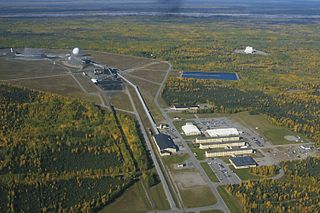
Clear Space Force Station is a United States Space Force radar station for detecting incoming ICBMs and submarine-launched ballistic missiles to NORAD's command center and to provide Space Surveillance data to the United States Space Force. Clear's AN/FPS-123 Upgraded Early Warning Radar is part of the Solid State Phased Array Radar System (SSPARS) which also includes those at Beale AFB, Cape Cod Space Force Station, RAF Fylingdales and Thule Site J. The "historic property" was one of the Alaska World War II Army Airfields and later a Cold War BMEWS site providing NORAD data to Colorado's BMEWS Central Computer and Display Facility (CC&DF).
The DRTE Computer was a transistorized computer built at the Defence Research Telecommunications Establishment (DRTE), part of the Canadian Defence Research Board. It was one of the earlier fully transistorized machines, running in prototype form in 1957, and fully developed form in 1960. Although the performance was quite good, equal to that of contemporary machines like the PDP-1, no commercial vendors ever took up the design, and the only potential sale to the Canadian Navy's Pacific Naval Laboratories, fell through. The machine is currently part of the Canadian national science and technology collection housed at the Canada Science and Technology Museum.
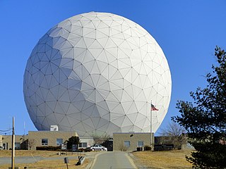
Haystack Observatory is a multidisciplinary radio science center, ionospheric observatory, and astronomical microwave observatory owned by Massachusetts Institute of Technology (MIT). It is in Westford, Massachusetts, in the United States, about 45 kilometers (28 mi) northwest of Boston. The observatory was built by MIT's Lincoln Laboratory for the United States Air Force and was called the Haystack Microwave Research Facility. Construction began in 1960, and the antenna began operating in 1964. In 1970 the facility was transferred to MIT, which then formed the Northeast Radio Observatory Corporation (NEROC) with other universities to operate the site as the Haystack Observatory. As of January 2012, a total of nine institutions participated in NEROC.
Gordon Hemenway Pettengill was an American radio astronomer and planetary physicist. He was one of the first to take radar from its original military application to its use as a tool for astronomy. He was professor emeritus at the Massachusetts Institute of Technology.

The Algonquin Radio Observatory (ARO) is a radio observatory located in Algonquin Provincial Park in Ontario, Canada. It opened in 1959 in order to host a number of the National Research Council of Canada's (NRC) ongoing experiments in a more radio-quiet location than Ottawa.

The Missile Defense Alarm System, or MIDAS, was a United States Air Force Air Defense Command system of 12 early-warning satellites that provided limited notice of Soviet intercontinental ballistic missile launches between 1960 and 1966. Originally intended to serve as a complete early-warning system working in conjunction with the Ballistic Missile Early Warning System, cost and reliability concerns limited the project to a research and development role. Three of the system's 12 launches ended in failure, and the remaining nine satellites provided crude infrared early-warning coverage of the Soviet Union until the project was replaced by the Defense Support Program. MiDAS represented one element of the United States's first generation of reconnaissance satellites that also included the Corona and SAMOS series. Though MIDAS failed in its primary role as a system of infrared early-warning satellites, it pioneered the technologies needed in successor systems.
The Minitrack Network was the first U.S. satellite tracking network to become operational, in 1957. It was used to track the flights of Sputnik, Vanguard, Explorer, and other early space efforts. Minitrack was the progenitor of Spacecraft Tracking and Data Acquisition Network (STADAN) and the Manned Space Flight Network (MSFN).

Northern Light was a concept mission for a robotic mission to Mars that would consist of a lander and a rover, being studied by a consortium of Canadian universities, companies and organisations. The primary contractor for the spacecraft was Thoth Technology Inc.

The Millstone Hill Steerable Antenna, or MISA, is a fully steerable dish antenna, 46 metres (151 ft) in diameter, designed by the Stanford Research Institute (SRI) in 1959. It is currently located at MIT Haystack Observatory in Westford, Massachusetts.

Space research is scientific study carried out in outer space, and by studying outer space. From the use of space technology to the observable universe, space research is a wide research field. Earth science, materials science, biology, medicine, and physics all apply to the space research environment. The term includes scientific payloads at any altitude from deep space to low Earth orbit, extended to include sounding rocket research in the upper atmosphere, and high-altitude balloons.
Project Space Track was a research and development project of the US Air Force, to create a tracking system for all artificial satellites of the Earth and space probes, domestic and foreign.

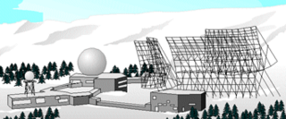
Thule Site J (J-Site) is a United States Space Force (USSF) radar station in Greenland near Pituffik Space Base for missile warning and spacecraft tracking. The northernmost station of the Solid State Phased Array Radar System, the military installation was built as the 1st site of the RCA 474L Ballistic Missile Early Warning System and had 5 of 12 BMEWS radars. The station has the following structures:

Eglin AFB Site C-6 is a United States Space Force radar station which houses the AN/FPS-85 phased array radar, associated computer processing system(s), and radar control equipment designed and constructed for the U. S. Air Force by the Bendix Communications Division, Bendix Corporation. Commencing operations in 1969, the AN/FPS-85 was the first large phased array radar. The entire radar/computer system is located at a receiver/transmitter building and is supported by the site's power plant, fire station, 2 water wells, and other infrastructure for the system. As part of the US Space Force's Space Surveillance Network its mission is to detect and track spacecraft and other manmade objects in Earth orbit for the Combined Space Operations Center satellite catalogue. With a peak radiated power of 32 megawatts the Space Force claims it is the most powerful radar in the world, and can track a basketball-sized object up to 22,000 nautical miles (41,000 km) from Earth.
The Gatineau Satellite Station is a Canadian satellite station located in Cantley near Gatineau, in the province of Québec. Like the Prince Albert Radar Laboratory, it was originally a military Radar station, operated by the Canadian Defence Research Telecommunications Establishment (DRTE), a division of the Canadian Defense Research Board. With the two satellites / radar stations, it is possible to monitor the whole airspace over Canada, as well as parts from the USA and Alaska.
References
- ↑ The Prince Albert Radar Laboratory, 1958 – 1963
- 1 2 PARL, Del Hansen
- ↑ Message Transmitted Via the Moon to the Prime Minister and People of Canada Upon the Opening of the Prince Albert Radar Laboratory
- ↑ Canadian Spatial Reference System, Algonquin Radio Observatory
- ↑ Prince Albert Satellite Station