The Mende are one of the two largest ethnic groups in Sierra Leone; their neighbours, the Temne people, constitute the largest ethnic group at 35.5% of the total population, which is slightly larger than the Mende at 31.2%. The Mende are predominantly found in the Southern Province and the Eastern Province, while the Temne are found primarily in the Northern Province and the Western Area, including the capital city of Freetown. Some of the major cities with significant Mende populations include Bo, Kenema, Kailahun, and Moyamba.

Bo, also commonly referred to as Bo Town, is the second largest city in Sierra Leone by landscape/geographical location and the largest city in the Southern Province. Bo is the capital and administrative centre of Bo District. The city of Bo had a population of 149,957 in the 2004 census and had a population of about 233,684 based on 2017 estimate. Bo is an urban centre, and lies approximately 160 miles (250 km) eastsoutheast of Freetown, and about 40 miles (71 km) to Kenema. Bo is the leading financial, educational and economic centre of southern Sierra Leone.

Kabala is the capital and largest town of Koinadugu District in the Northern Province of Sierra Leone. Kabala is one of the main towns in Northern Sierra Leone and is set in a rural landscape, surrounded by mountains.

Kenema is the third largest city in Sierra Leone, and the largest city in the country's Eastern Province. It is the capital of Kenema District and a major economic center of the Eastern Province. At the 2015 national census, Kenema had a population of 200,354. Kenema is located approximately 200 miles from Freetown, and 60 kilometres (40 mi) south of Bo.

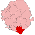
Pujehun District is a district in the Southern Province of Sierra Leone. Pujehun District is one of the sixteen Districts of Sierra Leone. Its capital and largest city is the town of Pujehun. The other major towns in the district include Gandorhun, Zimmi, Gendema, Masam, Bomi and Potoru. As of 2015, the district has a population of 345,577.

Bo District is a district in the Southern Province of Sierra Leone. It is one of the sixteen Districts of Sierra Leone. Bo District is the fourth most populous District in Sierra Leone. Its capital and largest city is the city of Bo, which is the third most populous city in Sierra Leone. other major towns in the district include Baoma, Bumpeh, Serabu, Sumbuya, Baiima and Yele.

Kailahun is the capital of Kailahun District in the Eastern Province of Sierra Leone. Kailahun is a major business and commercial center of Kailahun District. The population was 13,108 in the 2004 census, a 2006 estimate of 18,411 and a current estimate of about 30,411. Kailahun lies in the far east of Sierra Leone, approximately 200 miles east of Freetown, about 51 miles north east of Kenema, and near the border of Liberia.
Port Loko is the capital of Port Loko District and since 2017 the North West Province of Sierra Leone. The city had a population of 21,961 in the 2004 census and current estimate of 44,900. Port Loko lies approximately 36 miles north-east of Freetown. The area in and around Port Loko is a major bauxite mining and trade centre. The town lies on the main highway linking Freetown to Guinea's capital Conakry. It also lies on the over-land highway between Freetown and its major airport, Lungi International Airport, although most travellers complete this journey via the much shorter ferry or helicopter transit.
Bonthe is a coastal town located on Sherbro Island in Bonthe District in the southern Province of Sierra Leone. The town lies on the eastern shore of Sherbro Island, on the Sherbro River estuary. Bonthe is about 60 miles south-west of Bo and 187 miles south-east of Freetown.
The Sherbro people are a native people of Sierra Leone, who speak the Sherbro language; they make up 1.9% of Sierra Leone's population or 134,606. The Sherbro are found primarily in their homeland in Bonthe District, where they make up 40% of the population, in coastal areas of Moyamba District, and in the Western Area of Sierra Leone, particularly in Freetown. During pre-colonial days, the Sherbro were one of the most dominant ethnic group in Sierra Leone, but in the early 21st century, the Sherbro comprise a small minority in the nation. The Sherbro speak their own language, called Sherbro language.

Pendembu is a town in Kailahun District in the Eastern Province of Sierra Leone. The town population was 7,243 at the 2004 census but increased to 20,502 according to a more recent estimate. Pendembu lies approximately 36 miles from Kenema and about 235 east of Freetown. Pendembu is a trade center and is one of the main towns in Eastern Sierra Leone.
Waterloo is a city in the Western Area of Sierra Leone and the capital of the Western Area Rural District, which is one of the sixteen districts of Sierra Leone. Waterloo is located about twenty miles east of Freetown. Waterloo is the second largest city in the Western Area region of Sierra Leone, after Freetown. The city had a population of 34,079 in the 2004 census, and 55,000 as per a 2015 estimate. Waterloo is part of the Freetown metropolitan area.
Segbwema is a town in Kailahun District in the Eastern Province of Sierra Leone. The town is a major business and agricultural centre. Segbwema lies approximately 20 miles northeast of Kenema and about 225 miles south-east of Freetown. The population of Segbwema was 7,961 in the 2004 census with a current estimate of 16,532.

Sierra Leonean Americans are an ethnic group of Americans of full or partial Sierra Leonean ancestry. This includes Sierra Leone Creoles whose ancestors were African American Black Loyalists freed after fighting on the side of the British during the American Revolutionary War. Some African Americans trace their roots to indigenous enslaved Sierra Leoneans exported to the United States between the 18th and early 19th century. In particular, the Gullah people of partial Sierra Leonean ancestry, fled their owners and settled in parts of South Carolina, Georgia, and the Sea Islands, where they still retain their cultural heritage. The first wave of Sierra Leoneans to the United States, after the slavery period, was after the Sierra Leone Civil War in the 1990s and early 2000s. According to the American Community Survey, there are 34,161 Sierra Leonean immigrants living in the United States.

Sierra Leone is officially a secular state, although Islam and Christianity are the two main and dominant religions in the country. The constitution of Sierra Leone provides for freedom of religion and the Sierra Leone Government generally protects it. The Sierra Leone Government is constitutionally forbidden from establishing a state religion, though Muslim and Christian prayers are usually held in the country at the beginning of major political occasions, including presidential inauguration.
Samuel Town is a village in the Western Area Rural District of Sierra Leone. Farming is the major economic activity in the village.. Samuel Town lies about five miles from the Rural District main city of Waterloo and approximately 20 miles outside Freetown.
Tissana is a coastal village near the city of Waterloo in the Western Area Rural District of Sierra Leone. Tissana village is near the neighborhood village of Russell along the Freetown-Waterloo highway. The major economic activities in Tissana are the processing of salt, palm oil, and tourism.

Sierra Leone is home to about sixteen ethnic groups, each with its own language. In Sierra Leone, membership of an ethnic group often overlaps with a shared religious identity.
The Sierra Leone Creole people are an ethnic group of Sierra Leone. The Sierra Leone Creole people are descendants of freed African-American, Afro-Caribbean, and Liberated African slaves who settled in the Western Area of Sierra Leone between 1787 and about 1885. The colony was established by the British, supported by abolitionists, under the Sierra Leone Company as a place for freedmen. The settlers called their new settlement Freetown. Today, the Sierra Leone Creoles are 1.2 percent of the population of Sierra Leone.
Bendugu is the capital and largest town of Falaba District in the Northern Province of Sierra Leone. Bendugu is a very rural town and is also the seat of Mongo Chiefdom. Bendugu is located in close proximity to the international border with the Republic of Guinea. Bendugu is about 85 miles to Kabala, and is 300 miles east of Freetown. The main economic activity in the town is farming.