Pulltrouser Swamp

Last updated

Pulltrouser Swamp
Belize location map.svg
Archaeological site icon.svg
Pulltrouser Swamp
Alternative namePull Trouser Swamp
Location Orange Walk, Belize
Region Yucatan Peninsula
Coordinates 18°10′01″N88°34′00″W / 18.166870082576747°N 88.56666674910738°W / 18.166870082576747; -88.56666674910738 Coordinates: 18°10′01″N88°34′00″W / 18.166870082576747°N 88.56666674910738°W / 18.166870082576747; -88.56666674910738
History
Periods Preceramic
Cultures

Pulltrouser Swamp is a wetland area located in northern Belize, between the New River (Belize) and Hondo River (Belize). This area contains numerous archaeological sites belonging to the Maya civilization, the most studied features of which are the raised field structures. Three of these sites, called Raised-Field Site I, Raised-Field Site 2, and Raised-Field site 3, were excavated by archaeologists B.L. Turner and Peter D. Harrison. [1]

Contents

Settlements

Located north of Orange Walk in Belize is a Y-shaped settlement that makes up a series of complex elongated depressions. In Pulltrouser there were three different immediate settlements that surrounded the swamp equalling 8.5 km. In these settlements the key to organization was the utilization of hillsides and slopes for the raised fields. The people of Pulltrouser built their small living structures on terraces 2–3 meters above the swamp. There was also a hard platform composed of hard limestone and plaster built within the housing structure area. Within the settlement areas there was evidence of both ceramic and stone artifact production and use. [1]

Environment

There are four different vegetation types that occur at Pulltrouser Swamp; botan forest, escoba forest, saw grass community and grass savannah. Each of these appears to be spatially related to fluctuations of water in the area. [1]

The botan and escoba forest have been expanded as a result of the construction of fields and canals. Logging that has taken place over the last three hundred years has also altered the landscape and vegetation of the depression. The saw grass zone occurs at the center surrounded by the escoba then botan forest respectively. The grass savannah occurs in the western portion of the swamp. [1]

During construction of the canals and raised field system, it is believed Pulltrouser was simply a wet, non-forested area containing large amounts of water lilies. However, raised fields were constructed in marshlike environments since they are easier to channelize to construct raised fields. Archaeobotanical evidence suggests that several arboreal crops such as hog plum and avocado were evident at Pulltrouser Swamp as well as other evidence including maize and cotton. Pineapple, tobacco, vanilla were also found at the swamp most likely for the easy transportability and market value. [1]

Agriculture

People likely settled around swamps because of the rich faunal, plant, soil and water resources this environment made available. [2] Maize appears at the site around 890 cal BP. Pollen records show mass forest disturbance around 2500 B.C., this coincides with the appearance of maize pollen, a decline in tree pollen and an increase in charcoal. This is evidence for a rapid and extensive expansion of agriculture with maize as an important crop. [2] Further charcoal indicates that agriculture was expanded in the area between 1500 and 1300 B.C. and squash and bottle gourd were cultivated as well as maize. Evidence of what was originally thought to be canals at the site were found to be natural hummocks with no evidence of excavation. [2] Pohl et al. (1996) [2] suggest that the adoption of wetland agriculture was not a response to increases in population growth that created the need for more resources [1] but instead a reaction to the changes in groundwater levels they believe to have occurred around 15001300 B.C.

Raised fields

Aerial photography of ground patterns in Pulltrouser swamp has revealed that the Maya were utilising raised field agriculture in the area. Raised field agriculture is a form of hydraulic cultivation using raised and canalized fields creating conditions in which the earth is above its natural height. It has been suggested that these fields were in use from 400 BC-600AD, however this date could be biased due to repositioning of artifacts during the shifting of material in construction. The Pulltrouser swamp sites are often used as representative of this agricultural type in interpretations of the use of raised-field agriculture in Maya culture. The investigations at the site have involved both coring and excavations. [3]

There are two distinct ground patterns observed in Pulltrouser: "quadrilateral shapes in paired rows and quadrilateral to amorphous shapes in sectional or group patterns". [3] There are approximately 311ha of well-defined patterns located along the mainland edge, which have been measured to be 1m above the surrounding depressions. There are also 357 ha of less distinct patterns seen in both the East and West interiors of the site. [3] Running around these platforms are systems of different sized canals. There are three main categories of canals:

However, there is evidence of a fourth category, "extra-large canals" which run 200m long and 6-8m wide between South Pulltrouser and the New River, which have the suggested purposes of either controlling water-levels or being part of a transport system. [3]

Within the fields, the plant remains (phytoliths and pollen, for example) recovered help create a clearer picture of Mayan raised field agriculture in Pulltrouser. Maize was recovered in the form of pollen as well as a carbonized stalk found in one of the platforms. It is possible that this could be evidence of maize as agricultural crop or it could have been from mulch to aid the growth of other crops. Gosypium pollen was also recovered, which may represent either domesticated cotton or a wild population. The presence of water lily phytoliths suggests that there was permanent water in the canals during construction and/or use of the fields. It has been suggested that these water lilies may have been used as mulch, as modern day experiments show that water lily mulch is effective in retaining moisture, providing nutrients and other benefits. Unfortunately not enough organic material was recovered to conclusively show which crops or plants the Maya were using Pulltrouser Swamp for. [3]

Based on profiles, sediments and other information produced by excavation on the fields, Turner and Harrison [3] propose that the raised fields were created using the following steps:

  1. Creating a depression- In this step the soil is removed from the area and stored for later use, as the canals are cut into the earth removing subsoil material.
  2. Buildup of the field foundations- In this step the subsoil materials that were taken out of the ground to form the canals is now deposited on the area where the field will be (in between the canals). This build of material is generally built up to 200 cm above the bottom of canals.
  3. Fertile Soil- The original top soil that was first removed in the first stage is now added on top of the subsoil field foundations along with top soils taken from other areas and organics added for planting mediums.
  4. Planting and Use- The crops are then planted, grown, tended and harvested from the raised field platforms.

[3]

Ceramics

Much of the sample ceramics recovered at Pulltrouser Swamp are too small to clearly establish ceramic sequence or detailed understandings. However, there is some useful information that can be gained from the ceramics that were found. There is a presence of Early and Moderate Classic sherds (pieces) that are mixed and disturbed. The pottery style of the few specimens (bowls and vessels) that could be identified is linked to coastal sites in Belize and sites from Becan to Lake Bakalar. The sites from Becan to Lake Bakalar are also sites where raised field agriculture is prevalent. [1]

Stone tools

The stone tools (or "lithics") at Pulltrouser Swamp suggest that their use was during occupation of the site from the Late Preclassic to Late Classic Period (see Mesoamerican chronology). The tools found at the site were mostly for agricultural use or manufacturing agricultural products. There is little evidence that any of the tools were manufactured at the site. The types of tools found consisted of oval bifaces, tranchet bits, celts, picks, beveled bits, blades, and hammer stones. The majority of the tools are made from chert with some of chalcedony, cherty-limestone and obsidian. The oval bifaces are made from chert sourced near the site of Colha, Belize; these tools have wear consistent with agricultural work and were most likely used as hoes. The tranchet bits arrived fully formed at Pulltrouser, although there is evidence of retouching at the site. There are also blades made of chalcedony, stemmed knives and battered tools, sixteen of them made from chalcedony and two of cherty-limestone. [1] Obsidian tools were mostly prismatic blades that were made from abraded surfaces and were sourced from Guatemala. [1] [4] The lithics found at Pulltrouser suggest extensive trade with nearby sites, since there is little evidence of manufacturing at the site. In addition, many of the chert tools were recycled and reused suggesting that these items were highly valued. [1]

Molluscs

At the excavated sites within Pulltrouser Swamp there are many different species of mollusc shell types found. There were also many different uses; the most prominent shells being mixed terrestrial gastropods that were used in construction materials as fill in the raised fields. [1] Some of the different species and their uses include: Melongena melongena, used as a major food source. Pachychilus, used as a supplementary food source. The shells were a source of powdered lime used when cooking maize. Strombus gigas, used as a major food source. Larger shells were used for hoes as well as worked into ornaments or utensils. [1]

Notes

  1. 1 2 3 4 5 6 7 8 9 10 11 12 Turner, B.L. and Peter D. Harrison, 1983. Pulltrouser Swamp: ancient Maya habitat, agriculture, and settlement in northern Belize. Austin: University of Texas Press.
  2. 1 2 3 4 Pohl, Mary D., Kevin O. Pope, John G. Jones, John S. Jacob, Dolores R. Piperno, Susan D. deFrance, David L. Lentz, John A. Gifford, Marie E. Danforth & J. Kathryn Josser, 1996. "Early Agriculture in the Maya Lowlands". Latin American Antiquity 7(4):355-372
  3. 1 2 3 4 5 6 7 8 Turner, B.L. and Peter D. Harrison, 1981. "Prehistoric Raised Field Agriculture in the Maya Lowlands". Science, New Series, 213:399-405
  4. McAnany, Patricia, 1989. "Stone-Tool Production and Exchange in the Eastern Lowlands: The Consumer Perspective from Pulltrouser Swamp, Belize". American Antiquity, 54(2), p.332-346.

Related Research Articles

<span class="mw-page-title-main">Altun Ha</span>

Altun Ha is the name given to the ruins of an ancient Mayan city in Belize, located in the Belize District about 50 kilometres (31 mi) north of Belize City and about 10 kilometres (6.2 mi) west of the shore of the Caribbean Sea. The site covers an area of about 8 square kilometres (3.1 sq mi).

<span class="mw-page-title-main">Milpa</span> Mesoamerican crop growing system

In agriculture, milpa is a field for growing food crops and a crop-growing system used throughout Mesoamerica, especially in the Yucatán peninsula, in Mexico. The word milpa derives from the Nahuatl phrase mil-pa. Based on the agronomy of the Maya and of other Mesoamerican peoples, the milpa system is used to produce crops of maize, beans, and squash without employing artificial pesticides and artificial fertilizers.

<span class="mw-page-title-main">Lacandon people</span> Ethnic group

The Lacandon are one of the Maya peoples who live in the jungles of the Mexican state of Chiapas, near the southern border with Guatemala. Their homeland, the Lacandon Jungle, lies along the Mexican side of the Usumacinta River and its tributaries. The Lacandon are one of the most isolated and culturally conservative of Mexico's native peoples. Almost extinct in 1943, today their population has grown significantly, yet remains small, at approximately 650 speakers of the Lacandon language.

<span class="mw-page-title-main">Slash-and-burn</span> Farming method in which trees are cut and burnt to clear land

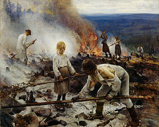
Slash-and-burn agriculture is a farming method that involves the cutting and burning of plants in a forest or woodland to create a field called a swidden. The method begins by cutting down the trees and woody plants in an area. The downed vegetation, or "slash", is then left to dry, usually right before the rainiest part of the year. Then, the biomass is burned, resulting in a nutrient-rich layer of ash which makes the soil fertile, as well as temporarily eliminating weed and pest species. After about three to five years, the plot's productivity decreases due to depletion of nutrients along with weed and pest invasion, causing the farmers to abandon the field and move to a new area. The time it takes for a swidden to recover depends on the location and can be as little as five years to more than twenty years, after which the plot can be slashed and burned again, repeating the cycle. In Bangladesh and India, the practice is known as jhum or jhoom.

<i>Chinampa</i> Type of Mesoamerican agriculture

Chinampa is a technique used in Mesoamerican agriculture which relies on small, rectangular areas of fertile arable land to grow crops on the shallow lake beds in the Valley of Mexico. They are built up on wetlands of a lake or freshwater swamp for agricultural purposes, and their proportions ensure optimal moisture retention. The United Nations designated it a Globally Important Agricultural Heritage System in 2018. The Aztecs created the very first Chinampa.

<span class="mw-page-title-main">Cerros</span>

Cerros is an Eastern Lowland Maya archaeological site in northern Belize that functioned from the Late Preclassic to the Postclassic period. The site reached its apogee during the Mesoamerican Late Preclassic and at its peak, it held a population of approximately 1,089 people. The site is strategically located on a peninsula at the mouth of the New River where it empties into Chetumal Bay on the Caribbean coast. As such, the site had access to and served as an intermediary link between the coastal trade route that circumnavigated the Yucatán Peninsula and inland communities. The inhabitants of Cerros constructed an extensive canal system and utilized raised-field agriculture.

<span class="mw-page-title-main">Ancient Maya cuisine</span> Diet of the Ancient Mesoamerican civilization

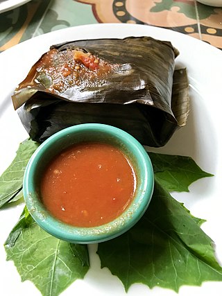
Ancient Maya cuisine was varied and extensive. Many different types of resources were consumed, including maritime, flora, and faunal material, and food was obtained or produced through strategies such as hunting, foraging, and large-scale agricultural production. Plant domestication concentrated upon several core foods, the most important of which was maize.

<span class="mw-page-title-main">Chunchucmil</span>

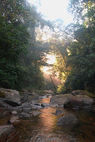
Chunchucmil was once a large, sprawling pre-Columbian Maya city located in the western part of what is now the state of Yucatán, Mexico.

<span class="mw-page-title-main">Las Vegas culture (archaeology)</span>

"Las Vegas culture" is the name given to many Archaic settlements which flourished between 8000 BCE and 4600 BCE.(10,000 to 6,600 BP) near the coast of present-day Ecuador. The name comes from the location of the most prominent settlement, Site No. 80, near the Las Vegas River and now within the city of Santa Elena. The Las Vegas culture represents "an early, sedentary adjustment to an ecologically complex coastal environment."

Waru Waru is an Aymara term for the agricultural technique developed by pre-Hispanic people in the Andes region of South America from Ecuador to Bolivia; this regional agricultural technique is also referred to as camellones in Spanish. Functionally similar agricultural techniques have been developed in other parts of the world, all of which fall under the broad category of raised field agriculture.

<span class="mw-page-title-main">Pre-Columbian Belize</span> Belize prior to Spanish colonisation

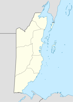
The Pre-Columbian Belize history is the period from initial indigenous presence, across millennia, to the first contacts with Europeans - the Pre-Columbian or before Columbus period - that occurred on the region of the Yucatán Peninsula that is present day Belize.

<span class="mw-page-title-main">Blue Creek (Belize)</span> River and archaeological site in Belize

Blue Creek is a riverine system and major archaeological site located in North-Western Belize, Central America. It is situated geographically on the Belize–Mexico border and then continues south across the Guatemala–Mexico border. The river is commonly known as the Rio Azul or ‘Azul River’ in Spanish, which translates to ‘blue river’ or ‘blue creek’ in English.

<span class="mw-page-title-main">Bladen Nature Reserve</span> Nature reserve in Toledo, Belize

Bladen Nature Reserve is a landscape of caves, sinkholes, pristine streams and rivers, undisturbed old growth rainforest and an abundance of highly diverse flora and fauna which includes a great deal of rare and endemic species.

Dennis E. Puleston Ph.D was an American archaeologist and ecologist. Puleston archaeology, biologyecology developed the ecological approach to the study of archaeology, looking at the manner in which humans adapt to their natural environment. His work involved pioneering interdisciplinarity methods which remain current to this day and led to a greater emphasis upon ecological and experimental archaeological research in the 80's and 90's. His work is still used to teach the importance of diversity in scientific interest, need for social relevance, and problem solving in archaeology classes due to the broadness of his approach. Puleston's work ranged from experiments in reconstruction and usefulness testing of chultuns or raised fields, building a traditional dugout canoe and using it to investigate otherwise unreachable areas, or challenging the belief that the Ancient Maya subsisted on a milpa agricultural complex – maize, beans, and squash.

<span class="mw-page-title-main">Colha, Belize</span> Mayan archaeological site in Belize

Colha, Belize is a Maya archaeological site located in northern portion of the country, about 52 km. north of Belize City, near the town of Orange Walk. The site is one of the earliest in the Maya region and remains important to the archaeological record of the Maya culture well into the Postclassic Period. According to Palma Buttles, “Archaeological evidence from Colha allows for the interpretation occupation from the Early Preceramic (3400-1900B.C.) to Middle Postclassic with population peaks occurring in the Late Preclassic and again in the Late Classic ”. These peaks in population are directly related to the presence of stone tool workshops at the site. Colha's proximity to an important source of high quality chert that is found in the Cenozoic limestone of the region and well traveled trade routes was utilized by the inhabitants to develop a niche in the Maya trade market that may have extended to the Greater Antilles. During the Late Preclassic and Late Classic periods, Colha served as a primary supplier of worked stone tools for the region. It has been estimated that the 36 workshops at Colha produced nearly 4 million chert and obsidian tools and eccentrics that were dispersed throughout Mesoamerica during the Maya era. This made it an important player in the trade of essential good throughout the area.

<span class="mw-page-title-main">Kʼaxob</span>

Kʼaxob is an archaeological site of the Maya civilization located in Belize. It was occupied from about 800 B.C. to A.D. 900. The site is located in northern Belize in the wetlands of Pulltrouser Swamp in proximity to the Sibun River Valley in central Belize. Research has shown that Kʼaxob was occupied from the Late Preclassic Period to the Early Postclassic Period. This period in time and the site is characterized by specific ceramic types as well as agriculture and an increase in social stratification. Kʼaxob is a village site centered on two pyramid plazas and later grew in size during the Early Classic Period to the Late Classic Period. The site includes a number of household, mounds and plazas. Kʼaxob is mostly based on residential and household living but also has some ritualistic aspects. Many of the structures at the site show evidence of household dwellings as well as ritual purposes. There are many burials at the site that illustrate the ritualistic aspects and social stratification at Kʼaxob. Many of the individuals, some more than others, were interned with beads made of shell as well as ceramic vessels, demonstrating this potential social stratification. The pottery vessels recovered from the site demonstrates regularity in the production of pottery. The most prominent type of ceramic vessels recovered from the site were 'serving bowls', with a tripodal base, and were present during the Early Classic Period. There is also evidence of specialized areas for pottery production. There are middens at the site that yielded a great deal of pottery sherds and are associated with structures that are believed to be kilns as well as with tools similar to modern pottery making tools. There is also some evidence of stone tool production at the site. The most common stone tool recovered from the site is a chert oval biface and is associated with agriculture and thought to have been used for weeding and hoeing.

<span class="mw-page-title-main">Prehistoric agriculture in the Southwestern United States</span>

The agricultural practices of the Native Americans inhabiting the American Southwest, which includes the states of Arizona and New Mexico plus portions of surrounding states and neighboring Mexico, are influenced by the low levels of precipitation in the region. Irrigation and several techniques of water harvesting and conservation were essential for successful agriculture. To take advantage of limited water, the southwestern Native Americans utilized irrigation canals, terraces (trincheras), rock mulches, and floodplain cultivation. Success in agriculture enabled some native Americans to live in communities which numbered in the thousands as compared to their former lives as hunter-gatherers in which their bands numbered only a few dozen.

In agriculture, a raised field is a large, cultivated elevation, typically bounded by water-filled ditches, that is used to allow cultivators to control environmental factors such as moisture levels, frost damage, and flooding. Examples of raised field agriculture can be found among some Pre-Hispanic cultures of Latin America, such as those from tropical lowlands and the Budi Lake Mapuche.

<span class="mw-page-title-main">Archaic period in Mesoamerica</span> Prehistoric period in Mesoamerica

The Archaic period, also known as the preceramic period, is a period in Mesoamerican chronology that begins around 8000 BCE and ends around 2000 BCE and is generally divided into Early, Middle, and Late Archaic periods. The period is preceded by the Paleoindian period and followed by the Preclassic period. Scholars have found it difficult to determine exactly when the Paleoindian period ends and the Archaic begins, but it is generally linked with changing climate associated with the transition from the Pleistocene to the Holocene epochs, and absence of extinct Pleistocene animals. It is also generally unclear when the Archaic period ends and the Preclassic period begins, though the appearance of pottery, large-scale agriculture, and villages signal the transition.

<span class="mw-page-title-main">Preclassic Period in Belize</span> Pre-Columbian period in Mesoamerican history

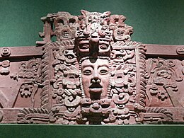
The Preclassic or Formative Period of Belizean, Mayan, and Mesoamerican history began with the Mayan development of ceramics during 2000 BC – 900 BC, and ended with the advent of Mayan monumental inscriptions in 250 AD.

References