Telfair Square is one of the 22 squares of Savannah, Georgia, United States. It is located in the second row of the city's five rows of squares, on Barnard Street and West President Street, and was laid out in 1733 as one of the first four squares. It is south of Ellis Square, west of Wright Square and north of Orleans Square. Liberty Square formerly stood to its west but was later paved over. The oldest building on the square is Telfair Academy, at 121 Barnard Street, which dates to 1818–1820.

Wright Square is one of the 22 squares of Savannah, Georgia, United States. It is located in the second row of the city's five rows of squares, on Bull Street and President Street, and was laid out in 1733 as one of the first four squares. It is south of Johnson Square, west of Oglethorpe Square, north of Chippewa Square and east of Telfair Square. The oldest building on the square is the William Waring Property, at 12 West State Street, which dates to 1825.

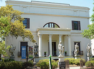
Oglethorpe Square is one of the 22 squares of Savannah, Georgia, United States. It is located in the second row of the city's five rows of squares, on Abercorn Street and East President Street, and was laid out in 1742. It is south of Reynolds Square, west of Columbia Square, north of Colonial Park Cemetery and east of Wright Square. The oldest building on the square is the Owens–Thomas House, at 124 Abercorn Street, which dates 1819.

Orleans Square is one of the 22 squares of Savannah, Georgia, United States. It is located in the middle row of the city's five rows of squares, on Barnard Street and West McDonough Street, and was laid out in 1815, shortly after the event it commemorates: General Andrew Jackson's victory at the Battle of New Orleans that January. It is south of Telfair Square, west of Chippewa Square and north of Pulaski Square. The oldest building on the square is the John Ash House, at 114–116 West Hull Street, which dates to 1817.

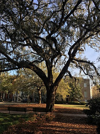
Pulaski Square is one of the 22 squares of Savannah, Georgia, United States. It is located in the fourth row of the city's five rows of squares, on Barnard Street and West Macon Street, and was laid out in 1837. It is south of Orleans Square, west of Madison Square and north of Chatham Square. It is known for its live oaks. The oldest buildings on the square are the Theodosius Bartow House and the Bernard Constantine House, which date to 1839.

Madison Square is one of the 22 squares of Savannah, Georgia, United States. It is located in the fourth row of the city's five rows of squares, on Bull Street and Macon Street, and was laid out in 1837. It is south of Chippewa Square, west of Lafayette Square, north of Monterey Square and east of Pulaski Square. The square is named for James Madison, fourth president of the United States. The oldest building on the square is the Sorrel–Weed House, at 6 West Harris Street, which dates to 1840.

Lafayette Square is one of the 22 squares of Savannah, Georgia, United States. It is located in the fourth row of the city's five rows of squares, on Abercorn Street and East Macon Street, and was laid out in 1837. It is south of Colonial Park Cemetery, west of Troup Square, north of Calhoun Square and east of Madison Square. The square is named for Gilbert du Motier, Marquis de Lafayette, the French hero of the American Revolution who visited Savannah in 1825. The oldest building on the square is the Andrew Low Carriage House, at 329 Abercorn Street, which dates to 1849.

Chatham Square is one of the 22 squares of Savannah, Georgia, United States. It is located in the southernmost row of the city's five rows of squares, on Barnard Street and West Wayne Street, and was laid out in 1847. It is south of Pulaski Square and west of Monterey Square in the southwestern corner of the city's grid of squares. The square is named for William Pitt, 1st Earl of Chatham. Although Pitt never visited Savannah, he was an early supporter of the Georgia colony, and both Chatham Square and Chatham County are named in his honor. The oldest building on the square is the Enoch Hendry Row House, at 108–112 West Taylor Street, which dates to 1851.
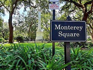
Monterey Square is one of the 22 squares of Savannah, Georgia, United States. It is located in the southernmost row of the city's five rows of squares, on Bull Street and Wayne Street, and was laid out in 1847. It is south of Madison Square, west of Calhoun Square, north of Forsyth Park and east of Chatham Square. The oldest building on the square is the Herman Kuhlman Duplex, at 22–24 West Taylor Street, which dates to 1851.
One of the 22 squares of Savannah, Georgia, United States, laid out in 1851 south of Lafayette Square, west of Whitefield Square, and east of Monterey Square, the location long named Calhoun Square has been unnamed since 2022. The oldest buildings on the square, the Adam Short Property and the Alexander Bennett House, date to 1853. Sometimes called Massie Square, the former Massie Common School House was built in 1855. The Wesley Monumental United Methodist Church, founded in 1868, is located on the western side of the square.

Whitefield Square is one of the 22 squares of Savannah, Georgia, United States. It is located in the southernmost row of the city's five rows of squares, on Habersham Street and East Wayne Street, and was the final square laid out, in 1851. It is south of Troup Square and east of Calhoun Square in the southeastern corner of Savannah's grid of squares. The oldest building on the square is at 412–414 East Taylor Street, which dates to 1855.

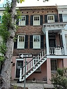
Gordon Row is a historic row house in Savannah, Georgia, United States. The largest single row house in Savannah, it comprises fifteen homes located between 101 and 129 West Gordon Street in the southeastern residential block of Chatham Square. Completed in 1854, it is a contributing property of the Savannah Historic District, itself on the National Register of Historic Places, as are its standing carriage houses to the rear. The row occupies the entire block between Barnard Street on the west and Whitaker Street on the east and sits directly opposite Chatham Square to Quantock Row on Taylor Street.

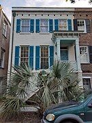
Scudder's Row is a historic row house in Savannah, Georgia, United States. It comprises the five homes from 1 to 9 East Gordon Street, in the southeastern residential block of Monterey Square, and was completed in 1853. It is a contributing property of the Savannah Historic District, itself on the National Register of Historic Places.

Quantock Row is a historic row house in Savannah, Georgia, United States. It comprises five units from 17 to 31 East Jones Street, and was completed in 1854. It is a contributing property of the Savannah Historic District, itself on the National Register of Historic Places. The row partly fills the block between Bull Street to the west and Drayton Street to the east.

Barnard Street is a prominent street in Savannah, Georgia, United States. Located between Jefferson Street to the west and Whitaker Street to the east, it runs for about 2.54 miles (4.09 km) from West Bay Street in the north to West 52nd Street in the south. The street is named for Sir John Barnard, Lord Mayor of London in 1737 and 1740. Its northern section passes through the Savannah Historic District, a National Historic Landmark District.

Gaston Street is a prominent street in Savannah, Georgia, United States. Located south of Gordon Street, it runs for about 0.77 miles (1.24 km) from Martin Luther King Jr. Boulevard in the west to East Broad Street in the east. Originally known only as Gaston Street singular, its addresses are now split between "West Gaston Street" and "East Gaston Street", the transition occurring at Bull Street in the center of the downtown area. The final block of East Gaston Street, from Price Street to East Broad Street, is offset to the north by a few yards from the rest of the street. Named for William Gaston, a prominent Savannahian merchant, the street is entirely within Savannah Historic District, a National Historic Landmark District.
Gordon Street is a prominent street in Savannah, Georgia, United States. Located between Taylor Street to the north and Gaston Street to the south, it runs for about 0.62 miles (1.00 km) from Martin Luther King Jr. Boulevard in the west to East Broad Street in the east. Originally known only as Gordon Street singular, its addresses are now split between "West Gordon Street" and "East Gordon Street", the transition occurring at Bull Street in the center of the downtown area.
Oglethorpe Avenue is a prominent street in Savannah, Georgia, United States. Located, in its downtown section, between York Street to the north and Hull Street to the south, it runs for about 1.26 miles (2.03 km) from the Atlantic Coastal Highway in the west to Randolph Street in the east. It was originally known as South Broad Street, then Market Street. After being named South Broad Street again for a period, it became known as Oglethorpe Avenue in 1897. It was formerly Oglethorpe Avenue singular, but its addresses are now split between "West Oglethorpe Avenue" and "East Oglethorpe Avenue", the transition occurring at Bull Street in the center of the downtown area. The street is named for the founder of the Savannah colony, James Edward Oglethorpe.

Taylor Street is a prominent street in Savannah, Georgia, United States. Located, in its downtown section, between Jones Street to the north and Gordon Street to the south, it runs for about 0.76 miles (1.22 km) from Martin Luther King Jr. Boulevard in the west to East Broad Street in the east. The street is named for general Zachary Taylor, hero of the Mexican–American War. The street is entirely within Savannah Historic District, a National Historic Landmark District.

The William Remshart Row House is a historic building in Savannah, Georgia, United States. It comprises the four properties between 102 and 111 West Jones Street, and was completed in 1853. It is a contributing property of the Savannah Historic District, itself on the National Register of Historic Places.