
The Massachusetts Bay Transportation Authority is the public agency responsible for operating most public transportation services in Greater Boston, Massachusetts. The MBTA transit network includes the MBTA subway with three metro lines, two light rail lines, and a five-line bus rapid transit system ; MBTA bus local and express service; the twelve-line MBTA Commuter Rail system, and several ferry routes. In 2022, the system had a ridership of 216,329,500, or about 724,500 per weekday as of the fourth quarter of 2022, of which the rapid transit lines averaged 273,000 and the light rail lines 90,700, making it the fourth-busiest rapid transit system and the third-busiest light rail system in the United States. As of the fourth quarter of 2022, average weekday ridership of the commuter rail system was 78,800, making it the sixth-busiest commuter rail system in the U.S.
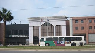
The New Orleans Regional Transit Authority is a public transportation agency based in New Orleans. The agency was established by the Louisiana State Legislature in 1979, and has operated bus and historic streetcar service throughout the city since 1983. With an annual ridership of over 4.6 million riders, the Regional Transit Authority is the largest public transit agency in the state of Louisiana.

Key bus routes of the Massachusetts Bay Transportation Authority (MBTA) system are 15 routes that have high ridership and higher frequency standards than other bus lines, according to the 2004 MBTA Service Policy. Together, they account for roughly 40% of the MBTA's total bus ridership. These key bus routes ensure basic geographic coverage with frequent service in the densest areas of Boston, and connect to other MBTA services to give access to other areas throughout the region.

South Attleboro station is an MBTA Commuter Rail Providence/Stoughton Line station in Attleboro, Massachusetts. It is located under Newport Avenue in the South Attleboro neighborhood, just north of the Rhode Island border. The station has two side platforms serving the two tracks of the Northeast Corridor, connected by a footbridge to a park-and-ride lot.

Providence station is a railroad station in Providence, Rhode Island, served by Amtrak and MBTA Commuter Rail. The station has four tracks and two island platforms for passenger service, with a fifth track passing through for Providence and Worcester Railroad freight trains. It is now the 11th busiest Amtrak station in the country, and the second-busiest on the MBTA Commuter Rail system outside of Boston.

The Rhode Island Public Transit Authority (RIPTA) provides public transportation, primarily buses, in the state of Rhode Island. The main hub of the RIPTA system is Kennedy Plaza, a large bus terminal in downtown Providence, Rhode Island. In 2020 the authority served an average of 36,776 people a day, in 36 out of 39 Rhode Island communities.

Wickford Junction is a commuter rail station located in North Kingstown, Rhode Island, United States. It is the southern terminus of the MBTA Commuter Rail Providence/Stoughton Line and serves as a park and ride location for commuters to Providence, Rhode Island, and Boston, Massachusetts. The station consists of a single high-level side platform on a stub-end siding next to the Northeast Corridor mainline.
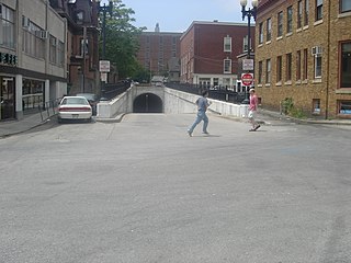
The East Side Trolley Tunnel, also known as the East Side Transit Tunnel or the College Hill Tunnel, is a bi-directional tunnel in Providence, Rhode Island, originally built for trolley use in 1914, and now used for public transit buses. The East Side Trolley Tunnel could be considered the first bus rapid transit link in North America, because of its exclusive and continuous bus use since 1948.

The Providence/Stoughton Line is an MBTA Commuter Rail service in Massachusetts and Rhode Island, primarily serving the southwestern suburbs of Boston. Most service runs entirely on the Northeast Corridor between South Station in Boston and Providence station or Wickford Junction station in Rhode Island, while the Stoughton Branch splits at Canton Junction and terminates at Stoughton. It is the longest MBTA Commuter Rail line, and the only one that operates outside Massachusetts. The line is the busiest on the MBTA Commuter Rail system, with 17,648 daily boardings in an October 2022 count.

The First and Second Avenues Line, also known as the Second Avenue Line, is a bus line in Manhattan, New York City, running mostly along Second Avenue from Lower Manhattan to East Harlem. Originally a streetcar line along Second Avenue, it is now the M15 bus route, the busiest bus route in the city and United States, carrying over 8.1 million people annually. MTA Regional Bus Operations, under the New York City Bus and Select Bus Service brands, operates the local out of the Tuskegee Airmen Bus Depot and the SBS from the Mother Clara Hale Bus Depot. Service is operated exclusively with articulated buses.

Kennedy Plaza, formerly Exchange Place, Exchange Terrace, or City Hall Park, is a rectangular public square that occupies a central portion of Downtown Providence, Rhode Island. Since the mid 19th century, the plaza has served as a civic and transportation hub.
The Riverview Corridor is a transit corridor connecting Downtown Saint Paul and the Mall of America in Bloomington via the Minneapolis-Saint Paul International Airport. The corridor serves an area from the Saint Paul Union Depot to the Mall via parts of the Metro Green Line and the Metro Blue Line, and a route running parallel to West 7th Street, which runs southwest from Downtown Saint Paul. The corridor creates a triangle connecting opposite ends of the Blue Line and Green Line.

The Providence metropolitan area is a region extending into eight counties in two states, and is the 38th largest metropolitan area in the United States. Anchored by the city of Providence, Rhode Island, it has an estimated population of 1,622,520, exceeding that of Rhode Island by slightly over 60%. The area covers almost all of Rhode Island. Thirty-eight of the 39 municipalities in the state are included; only Westerly is not. The Providence Metropolitan Statistical Area also extends into southern Massachusetts with an average population density of 2300 per mi2.

Attleboro station is a commuter rail station on the MBTA's Providence/Stoughton Line located in Attleboro, Massachusetts. By a 2018 count, Attleboro had 1,547 daily riders, making it the fourth busiest station on the system outside Boston.

Pawtucket/Central Falls station is a commuter rail station in Pawtucket, Rhode Island. It opened for MBTA Commuter Rail Providence/Stoughton Line service on January 23, 2023. The station has two side platforms serving the two tracks of the Northeast Corridor. It is also a hub for RIPTA local bus service.
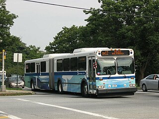
The Bx12 is a public transit line in New York City running along the 207th Street Crosstown Line, within the boroughs of Manhattan and the Bronx. The line runs along 207th Street in Upper Manhattan and along the continuous Fordham Road and Pelham Parkway in the Bronx.

The KC Streetcar is a streetcar system in Downtown Kansas City, Missouri. Construction began in May 2014. The system opened for service on May 6, 2016. The KC Streetcar is free to ride, as it is funded by a transportation development district. As of February 2023, the streetcar has had 11.4 million riders since opening in 2016. Extensions north to the waterfront and south to University of Missouri-Kansas City have been funded, with the southern extension under construction.

The B46 bus route constitutes a public transit corridor in Brooklyn, New York City. The route runs primarily along Utica Avenue north from the Kings Plaza shopping center through Eastern Brooklyn, with continued service west along Broadway to the Williamsburg Bridge Plaza Bus Terminal. The corridor was originally served by a streetcar line, known as the Utica and Reid Avenues Line, Utica−Reid Line, Reid−Utica Line, Reid Avenue Line, or Utica Avenue Line until 1951, when the line was replaced by bus service. The bus route is operated by MTA Regional Bus Operations under the New York City Transit brand.

The Metro A Line is a bus rapid transit line in the Twin Cities, Minnesota operated by Metro Transit. The A Line operates primarily along the Snelling Avenue corridor and travels through the cities of Minneapolis, Saint Paul, Falcon Heights, and Roseville. From the Blue Line in Minneapolis, the line travels past Minnehaha Park, through the Highland Village commercial area, past Macalester College, and connects to the Green Line near Allianz Field. The line continues through Saint Paul, past Hamline University, before traveling through Falcon Heights and Roseville, where the line passes the Minnesota State Fairgrounds, Har Mar Mall, and terminates at Rosedale Center.

The United Electric Railways Company (UER) was the Providence-based operator of the system of interurban streetcars, trolleybuses, and trolley freight in the state of Rhode Island in the early- to mid-twentieth century.

