RAF Tatenhill

Last updated

RAF Tatenhill
Ensign of the Royal Air Force.svg
Summary
Airport type Military
Owner Air Ministry
Operator Royal Air Force
Location Tatenhill, Staffordshire
Built 1941 (1941)
In use 1941-1947 (1947)
Elevation  AMSL 440 ft / 134 m
Coordinates 52°48′53″N001°45′40″W / 52.81472°N 1.76111°W / 52.81472; -1.76111 Coordinates: 52°48′53″N001°45′40″W / 52.81472°N 1.76111°W / 52.81472; -1.76111
Map
Staffordshire UK location map.svg
Airplane silhouette.svg
RAF Tatenhill
Location in Staffordshire
Runways
Direction Length Surface
ft m
04/22 0 0 Concrete
08/26 0 0 Concrete
18/36 0 0 Concrete
[1]

RAF Tatenhill is a former Royal Air Force satellite airfield in Tatenhill, Staffordshire, England, 4  NM (7.4 km; 4.6 mi) west of Burton on Trent. It was originally known as RAF Crossplains. [2]

Royal Air Force Aerial warfare service branch of the British Armed Forces

The Royal Air Force (RAF) is the United Kingdom's aerial warfare force. Formed towards the end of the First World War on 1 April 1918, it is the oldest independent air force in the world. Following victory over the Central Powers in 1918 the RAF emerged as, at the time, the largest air force in the world. Since its formation, the RAF has taken a significant role in British military history. In particular, it played a large part in the Second World War where it fought its most famous campaign, the Battle of Britain.

Tatenhill village in United Kingdom

Tatenhill is an ancient village and a civil parish located in a deep valley, between two hills, which gradually descend from the eastern border of Needwood Forest, 3.5 miles (5.6 km) west-southwest of Burton upon Trent, Staffordshire, England.

Staffordshire County of England

Staffordshire is a landlocked county in the West Midlands of England. It borders with Cheshire to the northwest, Derbyshire and Leicestershire to the east, Warwickshire to the southeast, West Midlands and Worcestershire to the south, and Shropshire to the west.

Contents

History

The field was built in 1941 as a satellite for No. 27 Operational Training Unit RAF (OTU) at RAF Lichfield later becoming a satellite airfield for RAF Wheaton Aston. [3] The design was the wartime RAF standard of three co-intersecting runways, east-west, north-south diagonal. The east-west runway was the only one suitable to safely accommodate bomber take off and landings (1,600 yards (1,500 m)) which hampered its operability. [4]

RAF Lichfield

Royal Air Force Station Lichfield also known as Fradley Aerodrome, was an operational training station from 1940 until 1958. It was situated in Fradley, 2 miles north east of Lichfield, Staffordshire, England. The airfield was the busiest airfield in Staffordshire during World War II. The airfield supported its own units as well as providing safe haven for many more. It was a control point for all aviation traffic that passed through the Birmingham area during the war and saw more aircraft movements than any other Staffordshire airfield.

Class A airfield

Class A airfields were World War II military installations constructed to specifications laid down by the British Air Ministry Directorate-General of Works (AMDGW). Intended for use by heavy bombers and transports, they were the standard air base design for the Royal Air Force as well as U.S. Army Air Forces units operating from the UK.

It was used as a bomber crew training field, which continued in varied training functions until 1944 with Vickers Wellington, Airspeed Oxford and Avro Anson aircraft for RAF Bomber Command. Later a single engine training unit arrived using the Miles Master aircraft. It was then used by the RAF School of Explosives after the disastrous explosion at nearby RAF Fauld, from October 1945 until January 1947. [1] During the post Second World War period when it was still under RAF Control, RAF tatenhill was used to break up unused and unwanted ammunition before it was dumped at sea. [5]

Vickers Wellington British twin-engined, long-range medium bomber

The Vickers Wellington is a British twin-engined, long-range medium bomber. It was designed during the mid-1930s at Brooklands in Weybridge, Surrey, led by Vickers-Armstrongs' chief designer Rex Pierson; a key feature of the aircraft is its geodetic airframe fuselage structure, which was principally designed by Barnes Wallis. Development had been started in response to Air Ministry Specification B.9/32, which was issued in the middle of 1932. This specification called for a twin-engined day bomber capable of delivering higher performance than any previous design. Other aircraft developed to the same specification include the Armstrong Whitworth Whitley and the Handley Page Hampden. During the development process, performance requirements such as for the tare weight changed substantially, and the engine used was not the one originally intended.

Airspeed Oxford twin-engine aircraft used for training British Commonwealth aircrews

The Airspeed AS.10 Oxford was a twin-engine monoplane aircraft developed and manufactured by Airspeed. It saw widespread use for training British Commonwealth aircrews in navigation, radio-operating, bombing and gunnery roles throughout the Second World War.

Avro Anson airplane

The Avro Anson is a British twin-engined, multi-role aircraft built by the aircraft manufacturer Avro. Large numbers of the type served in a variety of roles for the Royal Air Force (RAF), Fleet Air Arm (FAA), Royal Canadian Air Force (RCAF) and numerous other air forces before, during, and after the Second World War.

The airfield had a bomb dump on the south-east side and a number of frying pan dispersals were built on land to the north of the B5234 road, with hangars in this area too. [6]

Current use

The airfield remains in use as Tatenhill Airfield. A wartime Bellman hangar remains in use as of 2013.

Tatenhill Airfield airport in the United Kingdom

Tatenhill Airfield, previously Royal Air Force (RAF) Crossplains and later RAF Tatenhill, is a licensed airfield operated by Tatenhill Aviation Ltd, about 5 nautical miles west of Burton upon Trent, Staffordshire, England. It is part of the Needwood Survey, a 3000 hectare estate held by the Duchy of Lancaster in the area of the former Needwood Forest.

The Bellman Hangar was designed in the United Kingdom in 1936 by the Directorate of Works structural engineer, N. S. Bellman, as a temporary hangar capable of being erected or dismantled by unskilled labour with simple equipment and to be easily transportable. Commercial manufacturing rights were acquired by Head Wrightson & Co of Teesdale Iron Works, Thornaby-on-Tees. By November 1938, 10 had even been supplied to Russia.

Related Research Articles

RAF Digby Joint UK military communications and intelligence facility in Lincolnshire, England.

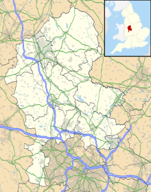
Royal Air Force Digby otherwise known as RAF Digby is Royal Air Force station located near Scopwick and 11.6 mi (18.7 km) south east of Lincoln, in Lincolnshire, England. The station is home to the tri-service Joint Service Signals Organisation, part of Joint Forces Intelligence Group of Joint Forces Command. Other units include the RAF Aerial Erector School, No. 54 Signals Unit and No. 591 Signals Unit.

RAF Gaydon

Royal Air Force Gaydon or more simply RAF Gaydon is a former Royal Air Force station located 5.2 miles (8.4 km) east of Wellesbourne, Warwickshire and 10.8 miles (17.4 km) north west of Banbury, Oxfordshire, England.

RAF Chelveston

Royal Air Force Chelveston or more simply RAF Chelveston is a former Royal Air Force station located on the south side of the A645, 5 miles (8.0 km) east of Wellingborough, near the village of Chelveston in Northamptonshire, England. During the Second World War the airfield was occupied by both the Royal Air Force and the United States Army Air Forces. It was given the USAAF designation Station 105.

RAF Grimsby

RAF Grimsby in Lincolnshire, England, was a Second World War Royal Air Force bomber aerodrome. It initially opened as a satellite station for the Wellington bombers of RAF Binbrook. By early 1943 the station was equipped with Lancaster bombers of 100 Squadron.

RAF Goxhill

Royal Air Force Goxhill or RAF Goxhill is a former Royal Air Force station located east of Goxhill, on the south bank of the Humber estuary, opposite the city of Kingston upon Hull, in north Lincolnshire, England.

RAF Oakley

RAF Oakley is a former Royal Air Force station between Oakley and Worminghall, Buckinghamshire, England. It was located in a flat, damp wooded area.

RAF Horsham St Faith 1939-1963 Royal Air Force station hear Norwich, Norfolk, England, UK

RAF Horsham St Faith is a former Royal Air Force station near Norwich, Norfolk, England which was operational from 1939 to 1963. It was then developed as Norwich International Airport.

RAF Hemswell

Royal Air Force Station Hemswell or more simply RAF Hemswell is a former Royal Air Force station located 7.8 miles (12.6 km) east of Gainsborough, Lincolnshire, England.

RAF Faldingworth

Royal Air Force Faldingworth or more simply RAF Faldingworth is a former Royal Air Force station used during and after the Second World War. It was located close to the village of Faldingworth in Lincolnshire, England.

RAF Metheringham

RAF Metheringham was a Royal Air Force station situated between the villages of Metheringham and Martin and 12.1 mi (19.5 km) south east of the county town Lincoln, Lincolnshire, England.

RAF Bircotes former Royal Air Force satellite airfield in South Yorkshire, England

RAF Bircotes is a former Royal Air Force satellite airfield located within South Yorkshire and the Metropolitan Borough of Doncaster and was formerly located within the boundary of Nottinghamshire.

RAF Lissett

Royal Air Force Station Lissett or more simply RAF Lissett is a former Royal Air Force station located 6.1 miles (9.8 km) south west of Bridlington, East Riding of Yorkshire, England.

RAF Melbourne

RAF Melbourne was a Royal Air Force station during the Second World War. Located 5 miles to the south-west of Pocklington, Yorkshire, England. The nearest village is Seaton Ross.

RAF Ashbourne

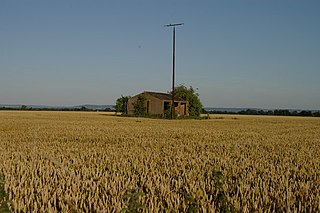
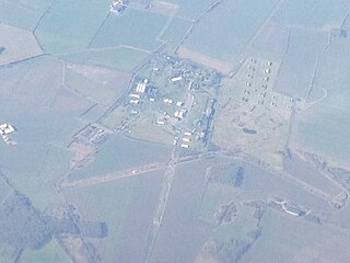
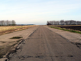
RAF Ashbourne is a former Royal Air Force airfield located approximately 1.5 miles (2.4 km) south-east of the town of Ashbourne, Derbyshire, England.

RAF Balado Bridge

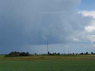
RAF Balado Bridge is a former military airfield located 2 mi (3.2 km) west of Kinross, in central Scotland. It opened in 1942 as a satellite airfield to RAF Grangemouth, and closed in 1957. It has since served as a NATO satellite station, a microlight flying base, and as the venue for the T in the Park music festival.

RAF Cammeringham

Royal Air Force Station Cammeringham or more simply RAF Cammeringham was a Royal Air Force station used by RAF Bomber Command between 1940 and 1945 and the Polish Air Force until 1946. The airfield was located between the A15 and B1398 roads, 10.3 mi (16.6 km) north of the city Lincoln, Lincolnshire, England and due east of the village of Ingham.

RAF Seighford

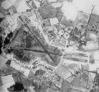
RAF Seighford is a former Royal Air Force station located 3.6 miles (5.8 km) northwest of Stafford, Staffordshire, England. The site was opened as a satellite/relief landing ground for RAF Hixon, 7.5 miles (12.1 km) to the east.

RAF Wheaton Aston

Royal Air Force Wheaton Aston or more simply RAF Wheaton Aston was a Royal Air Force station located just outside of the village of Wheaton Aston in Staffordshire, England. The base was actually in the hamlet of Little Onn which is 1.2 miles (2 km) north west of Wheaton Aston. The base was known locally as Little Onn or RAF Little Onn, but the policy of naming Royal Air Force stations was down to which parish the Station Headquarters was in.

RAF Hixon Royal Air Force station in Hixon, Staffordshire

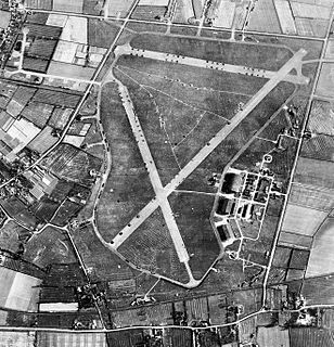
Royal Air Force Hixon or more simply RAF Hixon was a Royal Air Force station located on the north western edge of the village of Hixon in Staffordshire, England. The airfield was 7.5 miles (12.1 km) east of Stafford and bounded at the west and north by railways.

References

  1. 1 2 "RAF Tatenhill". Control Towers. Retrieved 26 April 2012.
  2. "Tatenhill (Burton-on-Trent)". Airfields of Britain Conservation Trust. Retrieved 30 July 2016.
  3. Historic England. "Tatenhill Airfield (929224)". PastScape. Retrieved 30 July 2016.
  4. Delve 2007, p. 305.
  5. "Bygones: Alas! wrote Churchill on report of RAF Fauld blast". Derby Telegraph. 6 October 2014. Retrieved 30 July 2016.
  6. Delve 2007, p. 303.

Bibliography

International Standard Book Number Unique numeric book identifier

The International Standard Book Number (ISBN) is a numeric commercial book identifier which is intended to be unique. Publishers purchase ISBNs from an affiliate of the International ISBN Agency.