Webster Plantation is a plantation in Penobscot County, Maine, United States. The population was 85 at the 2010 census.

The Iranian Plateau or the Persian Plateau is a geological feature in Western Asia and Central Asia. It is the part of the Eurasian Plate wedged between the Arabian and Indian plates, situated between the Zagros Mountains to the west, the Caspian Sea and the Kopet Dag to the north, the Armenian Highlands and the Caucasus Mountains in the northwest, the Strait of Hormuz and Persian Gulf to the south and the Indus River to the east in Pakistan.

Mokryan also known as Mukriyan, Mukri, Mokri, Mokrī, Mokriyan, was a Muslim Kurdish emirate centered at Mahabad ruling areas to the south and west of lake Urmia, for four centuries from the end of the 15th century.

Muṣaṣir Assyrian KURMu-ṣa-ṣir and variants, including Mutsatsir, Akkadian for Exit of the Serpent/Snake ), in Urartian Ardini was an ancient city of Urartu, attested in Assyrian sources of the 9th and 8th centuries BC.

Haft Tepe is an archaeological site situated in the Khuzestan Province in south-western Iran. At this site the remains of the Elamite city of Kabnak were discovered in 1908, and excavations are still carried out.

Altyndepe is a Bronze Age (BMAC) site in Turkmenistan, near Aşgabat, inhabited in the 3rd to 2nd millennia BC, abandoned around 1600 BC.

Lutomia Dolna is a village in the administrative district of Gmina Świdnica, within Świdnica County, Lower Silesian Voivodeship, in south-western Poland. Prior to 1945 it was in Germany.

Fingə is a village in the Lachin Rayon of Azerbaijan.

Daihō Station is a train station in Shimotsuma, Ibaraki Prefecture, Japan.
Kokoszka is a settlement in the administrative district of Gmina Ruciane-Nida, within Pisz County, Warmian-Masurian Voivodeship, in northern Poland. It lies approximately 3 kilometres (2 mi) north of Ruciane-Nida, 18 km (11 mi) west of Pisz, and 70 km (43 mi) east of the regional capital Olsztyn.
Łazy is a village in the administrative district of Gmina Mielno, within Koszalin County, West Pomeranian Voivodeship, in north-western Poland. It lies approximately 15 kilometres (9 mi) north of Koszalin and 146 km (91 mi) north-east of the regional capital Szczecin.

Jeonui Station is a railway station in Jeonui-myeon, Sejong City, South Korea.

Varbovo, Vidin Province is a village in the municipality of Chuprene, in Vidin Province, in northwestern Bulgaria.
Kõima, Lääneranna Parish is a village in Lääneranna Parish, Pärnu County in southwestern Estonia.
Shir Ashian Tepe is a prehistoric archaeological site in the Semnan Province of Iran, situated in Shir Ashian, about 15 kilometres southwest of Damghan.

Rabat is a city in the north east of Sardasht County, West Azerbaijan Province, in road of sardast - mahabad Kurdistan of Iran. In 2015, its population was 19,350, in 2,901 families.Peoples of rabat are Kurds that speak by Mokryan accent

Nowshiravan is a village in Dasht-e Zahab Rural District, in the Central District of Sarpol-e Zahab County, Kermanshah Province, Iran. At the 2006 census, its population was 194, in 36 families.
Rabat is a village in Beradust Rural District, Sumay-ye Beradust District, Urmia County, West Azerbaijan Province, Iran. At the 2006 census, its population was 194, in 36 families.
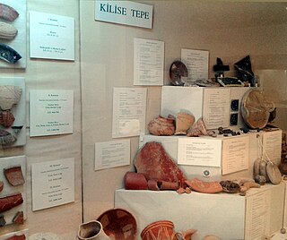
Kilise Tepe is a mound in Mersin Province, Turkey. It was formerly known as Maltepe. The original name of the mound is not known and Kilise Tepe in Turkish means "church-hill" referring to a church ruin.


