Navigation is a field of study that focuses on the process of monitoring and controlling the movement of a craft or vehicle from one place to another. The field of navigation includes four general categories: land navigation, marine navigation, aeronautic navigation, and space navigation.

A sextant is a doubly reflecting navigation instrument that measures the angular distance between two visible objects. The primary use of a sextant is to measure the angle between an astronomical object and the horizon for the purposes of celestial navigation.

In navigation, bearing or azimuth is the horizontal angle between the direction of an object and north or another object. The angle value can be specified in various angular units, such as degrees, mils, or grad. More specifically:
The term “set and drift” is used to describe external forces that affect a boat and keep it from following an intended course. To understand and calculate set and drift, one needs to first understand currents. Ocean currents are the horizontal movements of water from one location to another. The movement of water is impacted by: meteorological effects, wind, temperature differences, gravity, and on occasion earthquakes. Set is referred to as the current's direction, expressed in true degrees. Drift is referred to as the current's speed, which is usually measured in knots. “Leeway” refers to the amount of sidewards translation of a vessel drifting off of or away from the intended course of travel

The basic principles of air navigation are identical to general navigation, which includes the process of planning, recording, and controlling the movement of a craft from one place to another.
Piloting or pilotage is the process of navigating on water or in the air using fixed points of reference on the sea or on land, usually with reference to a nautical chart or aeronautical chart to obtain a fix of the position of the vessel or aircraft with respect to a desired course or location. Horizontal fixes of position from known reference points may be obtained by sight or by radar. Vertical position may be obtained by depth sounder to determine depth of the water body below a vessel or by altimeter to determine an aircraft's altitude, from which its distance above the ground can be deduced. Piloting a vessel is usually practiced close to shore or on inland waterways. Pilotage of an aircraft is practiced under visual meteorological conditions for flight.
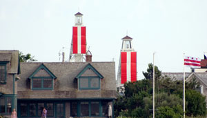
Leading lights, also known as range lights in the United States, are a pair of light beacons used in navigation to indicate a safe passage for vessels entering a shallow or dangerous channel; they may also be used for position fixing. At night, the lights are a form of leading line that can be used for safe navigation. The beacons consist of two lights that are separated in distance and elevation, so that when they are aligned, with one above the other, they provide a bearing. Range lights are often illuminated day and night.

In meteorology, Buys Ballot's law may be expressed as follows: In the Northern Hemisphere, if a person stands with their back to the wind, the atmospheric pressure is low to the left, high to the right. This is because wind travels counterclockwise around low pressure zones in the Northern Hemisphere. It is approximately true in the higher latitudes of the Northern Hemisphere, and is reversed in the Southern Hemisphere, but the angle between the pressure gradient force and wind is not a right angle in low latitudes.

A cross sea is a sea state of wind-generated ocean waves that form nonparallel wave systems. Cross seas have a large amount of directional spreading. This may occur when water waves from one weather system continue despite a shift in wind. Waves generated by the new wind run at an angle to the old.
Navigational instruments are instruments used by nautical navigators and pilots as tools of their trade. The purpose of navigation is to ascertain the present position and to determine the speed, direction, etc. to arrive at the port or point of destination.

The Yeoman Plotter was a plotter used on ships and boats to transfer GPS coordinates or RADAR echo locations onto a paper navigation chart and to read coordinates from the chart. It was manufactured from 1985 to 2014/2015 and was an intermediary step between traditional paper chart navigation and full electronic chart displays. It was easy to understand for people that were accustomed to paper charts and much cheaper than electronic chart displays available at the time. The continuing fall in prices of electronic chart displays, their increase in functionality such as radar overlay and the advent of cheap tablets eventually made the Yeoman plotter uncompetitive.

The American Practical Navigator, originally written by Nathaniel Bowditch, is an encyclopedia of navigation. It serves as a valuable handbook on oceanography and meteorology, and contains useful tables and a maritime glossary. In 1867 the copyright and plates were bought by the Hydrographic Office of the United States Navy. As of 2019 it is still published by the U.S. Government and is available free online from the National Geospatial-Intelligence Agency (NGA), the modern successor agency to the 19th Century Hydrographic Office. The publication is considered one of America's nautical institutions.

Passage planning or voyage planning is a procedure to develop a complete description of a vessel's voyage from start to finish. The plan includes leaving the dock and harbor area, the en route portion of a voyage, approaching the destination, and mooring, the industry term for this is 'berth to berth'. According to international law, a vessel's captain is legally responsible for passage planning, The duty of passage planning is usually delegated to the ship's navigation officer, typically the second officer on merchant ships.

The history of navigation, or the history of seafaring, is the art of directing vessels upon the open sea through the establishment of its position and course by means of traditional practice, geometry, astronomy, or special instruments. Many peoples have excelled as seafarers, prominent among them the Austronesians, the Harappans, the Phoenicians, the Iranians, the ancient Greeks, the Romans, the Arabs, the ancient Indians, the Norse, the Chinese, the Venetians, the Genoese, the Hanseatic Germans, the Portuguese, the Spanish, the English, the French, the Dutch, and the Danes.

Submarine navigation underwater requires special skills and technologies not needed by surface ships. The challenges of underwater navigation have become more important as submarines spend more time underwater, travelling greater distances and at higher speed. Military submarines travel underwater in an environment of total darkness with neither windows nor lights. Operating in stealth mode, they cannot use their active sonar systems to ping ahead for underwater hazards such as undersea mountains, drilling rigs or other submarines. Surfacing to obtain navigational fixes is precluded by pervasive anti-submarine warfare detection systems such as radar and satellite surveillance. Antenna masts and antenna-equipped periscopes can be raised to obtain navigational signals but in areas of heavy surveillance, only for a few seconds or minutes; current radar technology can detect even a slender periscope while submarine shadows may be plainly visible from the air.

The Radio Navigational Aids publication contains a detailed list of selected worldwide radio stations that provide services to the mariner. The publication is divided into chapters according to the nature of the service provided by the radio stations. The services include Radio direction finder and Radar Stations; stations broadcasting navigational warnings, time signals or medical advice; communication traffic for distress, emergency and safety including the Global Maritime Distress Safety System (GMDSS) and long range navigational aids. It also contains chapters describing procedures of the AMVER System, and the interim emergency procedures and communication instructions to be followed by U.S merchant vessels in times of crisis. A new edition of Publication 117 is published annually. This publication is available in its entirety on the website and there are also database queries available for much of the data contained within.
Position resection and intersection are methods for determining an unknown geographic position by measuring angles with respect to known positions. In resection, the one point with unknown coordinates is occupied and sightings are taken to the known points; in intersection, the two points with known coordinates are occupied and sightings are taken to the unknown point.

A linear scale, also called a bar scale, scale bar, graphic scale, or graphical scale, is a means of visually showing the scale of a map, nautical chart, engineering drawing, or architectural drawing. A scale bar is common element of map layouts.

Geopositioning, also known as geotracking, geolocalization, geolocating, geolocation, or geoposition fixing, is the process of determining or estimating the geographic position of an object.
