The Euphrates is the longest and one of the most historically important rivers of Western Asia. Together with the Tigris, it is one of the two defining rivers of Mesopotamia. Originating in Turkey, the Euphrates flows through Syria and Iraq to join the Tigris in the Shatt al-Arab, which empties into the Persian Gulf.

The geography of Iraq is diverse and falls into five main regions: the desert, Upper Mesopotamia, the northern highlands of Iraq, Lower Mesopotamia, and the alluvial plain extending from around Tikrit to the Persian Gulf.
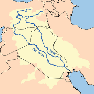
The Tigris is the eastern of the two great rivers that define Mesopotamia, the other being the Euphrates. The river flows south from the mountains of the Armenian Highlands through the Syrian and Arabian Deserts, and empties into the Persian Gulf.
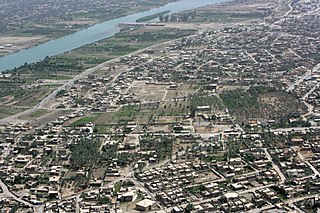
Ramadi is a city in central Iraq, about 110 kilometers (68 mi) west of Baghdad and 50 kilometers (31 mi) west of Fallujah. It is the capital and largest city of Al Anbar Governorate which touches on Syria, Jordan and Saudi Arabia. The city extends along the Euphrates which bisects Al Anbar. Founded by the Ottoman Empire in 1879, by 2018 it had about 223,500 residents, near all of whom Sunni Arabs from the Dulaim tribal confederation. It lies in the Sunni Triangle of western Iraq.

Lake Tharthar, and known in Iraq as Buhayrat ath-Tharthar, is an artificial lake created in 1956, situated 100 kilometers northwest of Baghdad between the Tigris and the Euphrates rivers.
The Atatürk Dam, originally the Karababa Dam, is the third largest dam in the world and it is a zoned rock-fill dam with a central core on the Euphrates River on the border of Adıyaman Province and Şanlıurfa Province in the Southeastern Anatolia Region of Turkey. Built both to generate electricity and to irrigate the plains in the region, it was renamed in honour of Mustafa Kemal Atatürk (1881–1938), the founder of the Turkish Republic. The construction began in 1983 and was completed in 1990. The dam and the hydroelectric power plant, which went into service after the upfilling of the reservoir was completed in 1992, are operated by the State Hydraulic Works (DSİ). The reservoir created behind the dam, called Atatürk Reservoir, is the third largest in Turkey.

The Tabqa Dam, or al-Thawra Dam as it is also named, most commonly known as Euphrates Dam, is an earthen dam on the Euphrates, located 40 kilometres (25 mi) upstream from the city of Raqqa in Raqqa Governorate, Syria. The city of Al-Thawrah is located immediately south of the dam. The dam is 60 metres (200 ft) high and 4.5 kilometres (2.8 mi) long and is the largest dam in Syria. Its construction led to the creation of Lake Assad, Syria's largest water reservoir. The dam was constructed between 1968 and 1973 with help from the Soviet Union. At the same time, an international effort was made to excavate and document as many archaeological remains as possible in the area of the future lake before they would be flooded by the rising water. When the flow of the Euphrates was reduced in 1974 to fill the lake behind the dam, a dispute broke out between Syria and Iraq that was settled by intervention from Saudi Arabia and the Soviet Union. The dam was originally built to generate hydroelectric power, as well as irrigate lands on both sides of the Euphrates. The dam has not reached its full potential in either of these objectives.

Lake Milh, also known as Lake Razzaza, is an artificial lake located a few miles west of Karbala, Iraq. The lake is located in a depression into which excess water from Lake Habbaniyah, which comes from the Euphrates River, is diverted through a controlled escape channel or canal. The lake is listed as a wetland of international importance. The lake is rather shallow and the water level changes seasonally. Due to its salt content and changing water level, this largest freshwater lake in Iraq has lost its important stock of fish species and only a few recreational areas exist around the lake.
Lake Habbaniyah is a lake located halfway between Ramadi and Fallujah near Al-Taqaddum (TQ) Air Base in Al Habbaniyah in Anbar Province, Iraq.
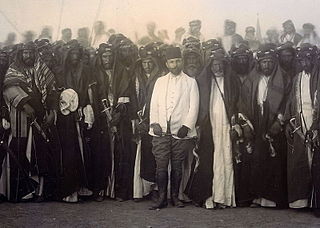
The two Battles of Ramadi were fought between the forces of the British and Ottoman Empires in July and September 1917 during World War I. The two sides contested the town of Ramadi in central Iraq, about 100 km west of Baghdad on the south bank of the Euphrates River, where an important Ottoman garrison was quartered. The town's strategic position on the road between Aleppo and Baghdad made it a key British target during the Mesopotamian campaign, but the hostile climatic conditions meant that it took two attacks over the course of three months for the town to fall.
Tajewala Barrage is a now decommissioned but existing old barrage across the Yamuna River, located in Yamuna Nagar District, in the state of Haryana, India. Completed in 1873, it regulated the flow of the Yamuna for irrigation in Uttar Pradesh and Haryana through two canals originating at this place namely Western Yamuna Canal and Eastern Yamuna Canal, as well as the municipal water supply to Delhi.

A man-made reservoir in Al-Anbar, Iraq, Lake Qadisiyah sits on the north side of the Haditha Dam.

Lake Assad is a reservoir on the Euphrates in Raqqa Governorate, Syria. It was created in 1974 when construction of the Tabqa Dam was completed. Lake Assad is Syria's largest lake, with a maximum capacity of 11.7 cubic kilometres (2.8 cu mi) and a maximum surface area of 610 square kilometres (240 sq mi). A vast network of canals uses water from Lake Assad to irrigate lands on both sides of the Euphrates. In addition, the lake provides drinking water for the city of Aleppo and supports a fishing industry. The shores of Lake Assad have developed into important ecological zones.

The Samarra Barrage is a multi-purpose barrage on the Tigris River adjacent (west) of Samarra and north of Baghdad, Iraq. The main purpose of the dam is to divert floodwater in the Tigris River to Lake Tharthar through the Tharthar depression along with irrigation and an 84 MW hydro-electricity station. It also serves to produce hydroelectric power and flood control – although the later has become less critical with the construction of the Mosul Dam upstream and several other large dams in Turkey.
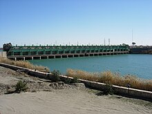
The Fallujah Barrage is a barrage on the Euphrates near Fallujah in Al Anbar Governorate, Iraq. Construction of the barrage was completed in 1985. Unlike many other dams in the Euphrates, the Fallujah Barrage does not include a hydroelectric power station and its main function is to raise the water level of the river for irrigation. The barrage consists of two separate parts. The main stretch of the barrage has ten gates measuring 16 by 8.5 metres, allowing a maximum discharge of 3,600 cubic metres (130,000 cu ft) per second. The second part on the left bank of the river has eight gates that are 6 metres (20 ft) wide. These gates divert water toward two separate irrigation channels. Their maximum discharge is 104 cubic metres (3,700 cu ft) per second.
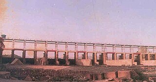
The Hindiya Barrage is a barrage on the Euphrates south of the town of Musayyib in Babil Governorate of Iraq. Located north of the Al-Hindiya District, it was designed by British civil engineer William Willcocks in response to the silting up of the Hillah branch of the Euphrates. Construction of the dam, with a length of over 250 metres (820 ft), lasted between 1911 and 1913. Between 1984 and 1989, a new dam was built several kilometres upstream as a replacement for the Hindiya Barrage.

Al-Hindiya District is a district of the Karbala Governorate, Iraq. Its largest town is Al-Hindiya, to the east of Karbala. The Hindiya Barrage in the north of the district controls floods and diverts water from the Euphrates into irrigation canals on both sides of the river. The district has been the scene of clashes with Turkish and British colonial forces, and more recently with American troops in 2003. The population is about 230,000, mostly Shia, including significant numbers of refugees. Infrastructure is poor, but efforts are being made to improve it.

Lower Mesopotamia is a historical region of Mesopotamia. It's located in the alluvial plain of Iraq from the Hamrin Mountains to the Faw Peninsula near the Persian Gulf.