Rasulpur, Bardhaman

Last updated

Rasulpur
Village
Rasulpur Rly Station.jpg
Rasulpur railway station
West Bengal location map.svg
Red pog.svg
Rasulpur
Location in West Bengal, India
India location map.svg
Red pog.svg
Rasulpur
Rasulpur (India)
Coordinates: 23°11′06″N88°01′47″E / 23.18513°N 88.02976°E / 23.18513; 88.02976 Coordinates: 23°11′06″N88°01′47″E / 23.18513°N 88.02976°E / 23.18513; 88.02976
CountryFlag of India.svg  India
State West Bengal
District Purba Bardhaman
Population
 (2011)
  Total5,091
Languages
  Official Bengali, English
Time zone UTC+5:30 (IST)
Telephone/STD code03213
Lok Sabha constituency Bardhaman Purba
Vidhan Sabha constituency Memari
Website purbabardhaman.gov.in

Rasulpur is a village in Memari I CD block in Bardhaman Sadar South subdivision of Purba Bardhaman district in the state of West Bengal, India.

Contents

Geography

Cities and towns in the Bardhaman Sadar South subdivision of Purba Bardhaman district
M: municipal city/ town, CT: census town, R: rural/ urban centre.
Owing to space constraints in the small map, the actual locations in a larger map may vary slightly

Location

23°11′06″N88°01′47″E / 23.18513°N 88.02976°E / 23.18513; 88.02976

Urbanisation

95.54% of the population of Bardhaman Sadar South subdivision live in the rural areas. Only 4.46% of the population live in the urban areas, and that is the lowest proportion of urban population amongst the four subdivisions in Purba Bardhaman district. [1] The map alongside presents some of the notable locations in the subdivision. All places marked in the map are linked in the larger full screen map.

Demographics

As per the 2011 Census of India Rasulpur had a total population of 5,091, of which 2,550 (50%) were males and 2,541 (50%) were females. Population below 6 years was 423. The total number of literates in Rasulpur was 3,930 (84.19% of the population over 6 years). [2]

Transport

Rasulpur station Rasulpur Rail station.jpg
Rasulpur station

Rasulpur railway station is situated on the Howrah-Bardhaman main line. [3]

Kolkata-Agra National Highway 19 (old numbering NH 2) passes near Rasulpur. [4]

State Highway 13 running from Palsit (in Bardhaman district) to Dankuni (in Hooghly district), incorporating old GT Road in the area, passes through Rasulpur and meets NH 19 at Palsit, near Rasulpur. [5]

Education

Rasulpur BM High School, established in 1876 at Nimo, is a Bengali-medium boys only, higher secondary school. [6]

Baidyadanga Girls High School, established in 1949, is a Bengali-medium girls only, higher secondary school. [7]

Related Research Articles

Memari Town in West Bengal, India

Memari is a town and a municipality in Purba Bardhaman district in the Indian state of West Bengal. Memari- city of Love

Guskara Town in West Bengal, India

Guskara is a city and a municipality under the Ausgram police station in Bardhaman Sadar North subdivision of Purba Bardhaman district in the Indian state of West Bengal.

Gotan Village in West Bengal, India

Gotan is a village in Raina II CD block in Bardhaman Sadar South subdivision of Purba Bardhaman district in the state of West Bengal, India.

Palsit Village in West Bengal, India

Palsit is a village in Burdwan II CD block in Bardhaman Sadar North subdivision of Purba Bardhaman district in the Indian state of West Bengal. Also the native village of Adrish Banerjee.

Masagram Village in West Bengal, India

Masagram is a village in Ajhapur gram panchayat of Jamalpur CD block in Bardhaman Sadar South subdivision of Purba Bardhaman district in the Indian state of West Bengal.

Bethuadahri Town in West Bengal, India

Bethuadahari is a town in the Nakashipara CD block in the Krishnanagar Sadar subdivision of the Nadia district of the state of West Bengal, India. It is almost 28 km from the district headquarters Krishnanagar city.Bethuadahari Wildlife Sanctuary is situated in the Bethuadahari town of Nadia District, West Bengal, India. The sanctuary is located beside National Highway 12. The sanctuary covers 67 hectares, and was established in 1980 to preserve a portion of the central Gangetic alluvial zone.

Salanpur Village in West Bengal, India

Salanpur is a village, in the Salanpur CD block in the Asansol Sadar subdivision of the Paschim Bardhaman district in the state of West Bengal, India.

Galsi, Bardhaman Village in West Bengal, India

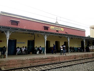
Galsi is a village in Galsi II CD Block in Bardhaman Sadar North subdivision of Purba Bardhaman district in the state of West Bengal, India.

Majhdia, Krishnaganj Village in West Bengal, India

Majhdia, also known as Majdia, is a village in the Krishnaganj CD block in the Krishnanagar Sadar subdivision of the Nadia district, West Bengal, India.

Kurmun Village in West Bengal, India

Kurmun is a village in Burdwan I CD block in Bardhaman Sadar North subdivision of Purba Bardhaman district in the state of West Bengal, India.

Ausgram, Bardhaman Village in West Bengal, India

Ausgram is a village in Ausgram I CD block in Bardhaman Sadar North subdivision of Purba Bardhaman district in the state of West Bengal, India.

Amrargar Village in West Bengal, India

Amarargar is a village in Ausgram II CD block in Bardhaman Sadar North subdivision of Purba Bardhaman district in the state of West Bengal, India.

Sagrai Village in West Bengal, India

Sagrai is a village in Khandaghosh CD block in Bardhaman Sadar South subdivision of Purba Bardhaman district in the state of West Bengal, India.

Mankar Village in West Bengal, India

Mankar is a village in Galsi I CD Block in Bardhaman Sadar North subdivision of Purba Bardhaman district in the state of West Bengal, India.

Kusumgram Village in West Bengal, India

Kusumgram is a village in Manteswar CD block in Kalna subdivision of Purba Bardhaman district in the state of West Bengal, India.

Mirzapur, Bardhaman Census Town in West Bengal, India

Mirzapur is a census town in Burdwan I CD Block in Bardhaman Sadar North subdivision of Purba Bardhaman district in the state of West Bengal, India.

Hatgobindapur Village in West Bengal, India

Hatgobindapur is a village in Burdwan II CD block in Bardhaman Sadar North subdivision of Purba Bardhaman district in the state of West Bengal, India.

Ukhrid Village in West Bengal, India

Ukhrid, an alternative named Ukharid, is a village and a gram panchayat, located in Khandaghosh CD block in Bardhaman Sadar South subdivision of Purba Bardhaman district in the state of West Bengal, India.

Kaliganj, Nadia Village in West Bengal, India

Kaliganj is a village in the Kaliganj CD block in the Krishnanagar Sadar subdivision of the Nadia district in the state of West Bengal, India.

Goda, Purba Bardhaman Census Town in West Bengal, India

Goda is a census town in Burdwan I CD Block in Bardhaman Sadar North subdivision of Purba Bardhaman district in the Indian state of West Bengal.

References

  1. "District Statistical Handbook 2014 Bardhaman". Table 2.2. Department of Statistics and Programme Implementation, Government of West Bengal. Retrieved 25 January 2019.
  2. "2011 Census – Primary Census Abstract Data Tables". West Bengal – District-wise. Registrar General and Census Commissioner, India. Retrieved 18 March 2017.
  3. "63501/ Mowrah-Barddhaman Fast Memu Local". Time Table. indiarailinfo. Retrieved 18 March 2017.
  4. "Rationalisation of Numbering Systems of National Highways" (PDF). New Delhi: Department of Road Transport and Highways . Retrieved 18 March 2017.
  5. "List of State Highways in West Bengal". West Bengal Traffic Police. Retrieved 18 March 2017.
  6. "Rasulpur BM High School". ICBSE. Retrieved 18 March 2017.
  7. "Baidyadanga Girls High School". ICBSE. Retrieved 18 March 2017.