
The Red Hills or Tallahassee Hills is a region of gently rolling hills in the southeastern United States. It is a geomorphic region and an ecoregion.
The Red Hills or Tallahassee Hills is a region of gently rolling hills in the southeastern United States. It is a geomorphic region and an ecoregion.
The Red Hills physiographic region of northern Florida was defined in 1914 as most of Leon County north of the Cody Scarp, and small portions of southernmost Grady and Thomas counties in Georgia. The original tree cover of the region was a shortleaf pine-oak-hickory woodland with deep sandy clay soil. A wider definition of the Red Hills Region includes Jefferson County, Florida north of the Cody Scarp and the southern portions of Grady and Thomas counties in Georgia. This larger region consists of about 2,400 square kilometers (930 square miles) that is bounded by the Aucilla River on the east and northeast, by the Ochlockonee River on the west and northwest, and by the Cody Scarp on the south. The Red Hills physiographic region is part of the Tallahassee Hills/Valdosta Limesink ecoregion, which extends across northern Florida and southern Georgia from the Apalachicola River to the vicinity of Valdosta, Georgia. [1] [2] [3] [4]
A wider Red Hills section of Florida has been defined as extending 150 miles (240 kilometers) along the Alabama and Georgia borders, including, from east to west, Madison, Jefferson, Leon, Gadsden and Jackson counties. [5]
There is a Red Hills Physiographic Province in south central Alabama. [6]
The area was first settled by Paleo-Indians in and around the various lakes in the southern part of the Red Hills. The Apalachee were found here in the 16th century, and were almost annihilated through wars, disease, and slavery. In the 18th century, the Seminoles made the Red Hills their home until the early 19th century and the Seminole Wars.
Also in the 19th century, white settlers began cotton plantations, which thrived until the Civil War. At one time, Leon County, Florida, was the 5th largest producer of cotton among all counties in Georgia and Florida. After the Civil War, many of the Red Hills' plantations became winter homes and quail hunting plantations for wealthy northerners; the area between Thomasville and Tallahassee is still home to dozens of such plantations, such as Greenwood, Pebble Hill, and Goodwood.
Rolling hills, ravines and gullies covered by forests and the large lakes of Lake Jackson, Lake Iamonia, Lake Miccosukee, Lake Lafayette, and Lake Talquin. The highest point in the Red Hills is 280 feet (85 meters) north of Tallahassee by 10 miles (16 kilometers). The soil is red clay deposited during the last ice age from the Appalachian Mountains. Rivers running through the Red Hills Region are the Aucilla River, Ochlockonee River, and Telogia Creek. The St. Marks River is subterranean until it meets the surface in the Woodville Karst Plain.
The area is covered in a number of native species. There are a variety of oak including southern live oak, water oak, laurel oak, white oak, overcup oak, post oak, black oak [7] as well as other hardwood trees such as American sweetgum, a variety of magnolia, as well as hickory, flowering dogwood, red maple, and redbud. Conifers are also abundant, including shortleaf pine, and loblolly pine. The Red Hills are home to some of the last remnants of the great longleaf pine forests remaining in the nation.[ citation needed ]
The Red Hills Region supports the northern bobwhite quail, white-tailed deer, red fox, raccoon, eastern gray squirrel, nine-banded armadillo, black bear, migratory bird, federally endangered red-cockaded woodpecker, gopher tortoise, eastern diamondback rattlesnake, eastern tiger salamander, and many other animals and plants. [8]
The Red Hills Region serves as one of the highest recharge areas for the Floridan aquifer — which is critical to the drinking water supply for residents of Florida, Georgia, and Alabama. The Red Hills Region also has the largest concentration of undeveloped plantation lands in the United States. The Red Hills has been identified for special conservation efforts, and The Nature Conservancy has designated the Red Hills as one of America's "Last Great Places."
Each spring, the equestrian community meets for the Red Hills Horse Trials, an Olympics qualifying event held at Elinor Klapp-Phipps Park.

The Boston Mountains is a Level III ecoregion designated by the Environmental Protection Agency (EPA) in the U.S. states of Arkansas and Oklahoma. Part of the Ozarks, the Boston Mountains are a deeply dissected plateau. The ecoregion is steeper than the adjacent Springfield Plateau to the north, and bordered on the south by the Arkansas Valley. The Oklahoma portion of the range is locally referred to as the Cookson Hills. There are several theories of how the mountains were named, though apparently none are related to the Massachusetts city.
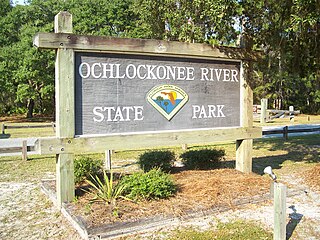
Ochlockonee River State Park is a Florida State Park located in Wakulla County, Florida, south of the town of Sopchoppy in the Florida Panhandle. Located off of U.S. 319 on the Ochlockonee River, just north of the Gulf of Mexico coast, it is surrounded by the Apalachicola National Forest and the St. Marks National Wildlife Refuge and provides important habitat for the endangered red-cockaded woodpecker.
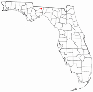
Bradfordville is an unincorporated community in northern Leon County, Florida, United States. It is 8 miles (13 km) north of Tallahassee and south of the Florida/Georgia state line by 8 miles (13 km) at the intersection of US 319 and County Road 0342. Its elevation is 223 feet.
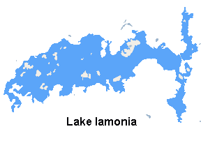
Lake Iamonia⟨aɪ ˈmoʊ njə⟩ is a large, subtropical prairie lake in northern Leon County, Florida, United States, created during the Pleistocene epoch.
Tall Timbers Research Station and Land Conservancy is a research and learning facility located in northern Leon County, Florida, just off County Road 12 on the north side of Lake Iamonia. Tall Timbers researches the areas of fire ecology, resource management, forestry, game bird management, and vertebrate ecology.

The Cody Scarp or Cody Escarpment is located in north and north central Florida United States. It is a relict scarp and ancient persistent topographical feature formed from an ancient early Pleistocene shorelines of ~1.8 million to 10,000 years BP during interglacial periods. The Cody Scarp has a slope of 5% to 12%.

The Florida Trail is one of eleven National Scenic Trails in the United States. It currently runs 1,500 miles (2,400 km), from Big Cypress National Preserve to Fort Pickens at Gulf Islands National Seashore, Pensacola Beach. Also known as the Florida National Scenic Trail, the Florida Trail provides permanent non-motorized recreation opportunity for hiking and other compatible activities and is within an hour of most Floridians. The Florida National Scenic Trail is designated as a National Scenic Trail by the National Trails System Act of 1968.

The Appalachian mixed mesophytic forests is an ecoregion of the temperate broadleaf and mixed forests biome, as defined by the World Wildlife Fund. It consists of mesophytic plants west of the Appalachian Mountains in the Southeastern United States.
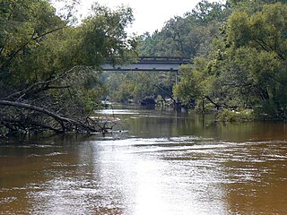
The Ochlockonee River is a fast running river, except where it has been dammed to form Lake Talquin in Florida, originating in Georgia and flowing for 206 miles (332 km) before terminating in Florida.
The history of Leon County, Florida, much like the History of Tallahassee, dates back to the settlement of the Americas. Beginning in the 16th century, the region was colonized by Europeans, becoming part of Spanish Florida. In 1819, the Adams–Onís Treaty ceded Spanish Florida, including modern-day Leon County, to the United States. Named for Spanish explorer Juan Ponce de León, Leon County became an official U.S. county in 1824; the American takeover led to the county's rapid expansion as growing numbers of cotton plantations began to spring up nearby, increasing Leon County's population significantly.

Orchard Pond Plantation was a large cotton plantation originally of 8754 acres, developed and owned in the 19th century by Richard Keith Call, attorney, planter and future Territorial Governor, in what is now northwestern Leon County, Florida, United States. In 1860 he owned 118 slaves to work the 1300 acres of improved land.
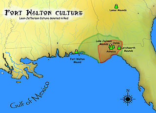
The Leon-Jefferson Culture is the term used by archaeologists for a protohistoric Native American archaeological culture that flourished in southeastern North America from approximately 1500–1704 CE and is associated with the historic Apalachee people. It was located in and named for the present day Leon and Jefferson counties in northern Florida of the Southeastern United States

The Wacissa River is a large, spring-fed stream located in south-central Jefferson County, Florida. Its headwaters are located about a mile south of the town of Wacissa, where the river emerges crystal clear from a group of large limestone springs. From its headsprings, the river flows approximately 12 miles (19 km) south through a broad cypress swamp before breaking into numerous braided channels which join the Aucilla River a few miles further south. The river is managed by the Florida Fish & Wildlife Conservation Commission as part of the Aucilla Wildlife Management Area, and has been declared an Outstanding Florida Waterway by the Florida Department of Environmental Protection.

The eastern woodlands of the United States covered large portions of the southeast side of the continent until the early 20th century. These were in a fire ecology of open grassland and forests with low ground cover of herbs and grasses.

The Ozark Highlands is a Level III ecoregion designated by the Environmental Protection Agency (EPA) in four U.S. states. Most of the region is within Missouri, with a part in Arkansas and small sections in Oklahoma and Kansas. It is the largest subdivision of the region known as the Ozark Mountains, less rugged in comparison to the Boston Mountains in Arkansas, the highest part of the Ozarks.

The Middle Atlantic coastal forests are a temperate coniferous forest mixed with patches of evergreen broadleaved forests along the coast of the southeastern United States.

The Southeastern mixed forests are an ecoregion of the temperate broadleaf and mixed forest biome, in the lower portion of the Eastern United States.

The Southeastern conifer forests are a temperate coniferous forest ecoregion of the southeastern United States. It is the largest conifer forest ecoregion east of the Mississippi River. It is also the southernmost instance of temperate coniferous forest within the Nearctic realm.

The Arkansas Valley is a Level III ecoregion designated by the Environmental Protection Agency (EPA) in the U.S. states of Arkansas and Oklahoma. It parallels the Arkansas River between the flat plains of western Oklahoma and the Arkansas Delta, dividing the Ozarks and the Ouachita Mountains with the broad valleys created by the river's floodplain, occasionally interrupted by low hills, scattered ridges, and mountains. In Arkansas, the region is often known as the Arkansas River Valley, especially when describing the history and culture of the region.

Herbert L. Stoddard was an American naturalist, conservationist, forester, wildlife biologist, ecologist, ornithologist, taxidermist, and author. In the 20th century he earned a reputation for being one of the American Southeast's most prominent conservationists and a pioneering forest ecologist. He is most well known for his seminal book, The Bobwhite Quail: Its habits, preservation, and increase (1931). He is also widely credited with advocating for the practice of prescribed fire as a tool for wildlife management. He was married to Ada Wechselberg, with whom he had one son, Herbert "Sonny" L. Stoddard Jr.
{{cite web}}: CS1 maint: multiple names: authors list (link)