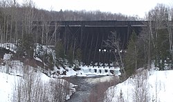
In 1894, prior to the construction of the steel dam, the Atlantic Mining Company built a timber crib dam across the Salmon Trout River. The dam created a reservoir which supplied water to the Atlantic stamp mill which extracted copper from ore-bearing rock. With the growth of the Atlantic stamp mill and the construction of the Baltic Mining Companymill nearby, this reservoir proved to be insufficient, and in 1901 the steel dam was built. It was designed by J. F. Jackson and built by the Wisconsin Bridge and Iron Company. The old timber crib dam remained in place, submerged, upstream of the steel dam. A system of spillways, sluices (or launders as they are referred to in contemporary texts), and pipes brought water downhill to the stamp mills. The dam itself measures 74ft (23 m) high at its center and extends for a length of 1,006ft (307 m) across the river. Access to the reservoir was shared by the Atlantic and Baltic mines, which had a common board of directors.
The dam operated for several decades, until the mines closed. After that time, the dam was no longer maintained. On Easter morning of 1941, the spillway behind the dam broke, causing a flood. There was little damage to the steel part of the dam, but with the mining operations stopped, the dam owners had the spillway valves opened. However, there were still incidents of overtopping,[2] and the Copper Range Company (successor to Atlantic Mine Company and owner of the dam) had large holes cut in it in 1979 so that it would not retain water. This lowered the level of the reservoir, revealing the earlier timber dam.[3]
Ownership of the dam was transferred to Stanton Township in 1992. Fears that the timber dam might fail and Michigan's Department of Environmental Quality considering the dam a "significant hazard" forced the township to consider renovating the dam in 2001. Five options were proposed for a long-term fix for the dam. These options ranged from repairing the steel and wooden dams for $311,000 to restoring/reconstructing the entire structure for over a million dollars. Stanton Township could not afford to do any of the proposed options, so another option was sought out. A short-term fix was found to make the dam safer. The upper 13 feet of the wooden structure was removed in 2004 to bring the water level down and relieve some of the pressure. A more permanent repair is still needed. A recent study[when?] by a team of students from Michigan Technological University determined that both dams are likely to remain safe for the foreseeable future.[citation needed]
Redridge Steel Dam (upstream side, showing holes cut)The underside of the western end of the steel dam, downstream side
Construction information
Steel dams use relatively thin steel plates in contact with the water body, with a framework of steel behind them transmitting the load to the ground. The plates are slanted upwards in the direction of water flow, so that the weight of the water puts compressive forces on the girders holding the plates up. This transmits force to the ground without the bending moment that a vertical wall of plates would engender. It was believed at the time that these dams could be constructed faster and more cheaply than masonry dams.[4]
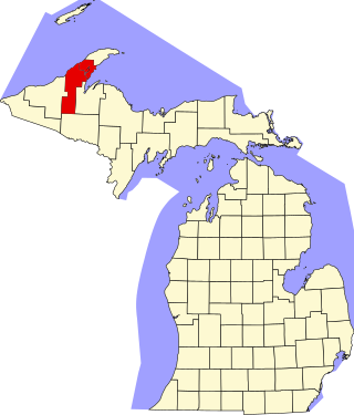
Redridge is in Houghton County, one of the more rugged counties in Michigan, and access to the dam site is relatively challenging, although there is a history of Michigan Technological University students making pilgrimages to the site, especially those interested in industrial archaeology.
Punmia, B. P. (1992). Irrigation and Water Power Engineering. Firewall Media. p.300. One of few sources to mention steel dams, this book says there are 3 extant in the U.S. and gives some info.
A dam is a barrier that stops or restricts the flow of surface water or underground streams. Reservoirs created by dams not only suppress floods but also provide water for activities such as irrigation, human consumption, industrial use, aquaculture, and navigability. Hydropower is often used in conjunction with dams to generate electricity. A dam can also be used to collect or store water which can be evenly distributed between locations. Dams generally serve the primary purpose of retaining water, while other structures such as floodgates or levees are used to manage or prevent water flow into specific land regions.
Oroville Dam is an earthfill embankment dam on the Feather River east of the city of Oroville, California, in the Sierra Nevada foothills east of the Sacramento Valley. At 770 feet (235 m) high, it is the tallest dam in the U.S. and serves mainly for water supply, hydroelectricity generation, and flood control. The dam impounds Lake Oroville, the second-largest reservoir in California, capable of storing more than 3.5 million acre-feet (1.1×10^12 US gal; 4.3×10⁹ m3).
Lake Oroville is a reservoir formed by the Oroville Dam impounding the Feather River, located in Butte County, northern California. The lake is situated 5 miles (8 km) northeast of the city of Oroville, within the Lake Oroville State Recreation Area, in the western foothills of the Sierra Nevada. Known as the second-largest reservoir in California, Lake Oroville is treated as a keystone facility within the California State Water Project by storing water, providing flood control, recreation, freshwater releases to assist in controlling the salinity intrusion into the Sacramento-San Joaquin Delta and protecting fish and wildlife.
The Mactaquac Dam is an embankment dam used to generate hydroelectricity in Mactaquac, New Brunswick. It dams the waters of the Saint John River and is operated by NB Power with a capacity to generate 670 megawatts of electricity from 6 turbines; this represents 20 percent of New Brunswick's power demand.
The Ashfork Bainbridge Steel Dam, the first large steel dam in the world, and one of only three ever built in the United States, was constructed in 1898 by the Atchison, Topeka and Santa Fe Railway (ATSF) to supply water for railway operations near Ash Fork, Arizona. It is named for the town of Ash Fork, and for Francis H. Bainbridge, a civil engineer and graduate of Rensselaer Polytechnic Institute (RPI), a member of the Rensselaer Society of Engineers, and an engineer for ATSF. The dam has been listed on the National Register of Historic Places since 1976.
A steel dam is a type of dam that is made of steel, rather than the more common masonry, earthworks, concrete or timber construction materials.
This is a list of the National Register of Historic Places listings in Houghton County, Michigan.
An embankment dam is a large artificial dam. It is typically created by the placement and compaction of a complex semi-plastic mound of various compositions of soil or rock. It has a semi-pervious waterproof natural covering for its surface and a dense, impervious core. This makes the dam impervious to surface or seepage erosion. Such a dam is composed of fragmented independent material particles. The friction and interaction of particles binds the particles together into a stable mass rather than by the use of a cementing substance.
Kachess Lake is a lake and reservoir along the course of the Kachess River in Washington state, US. The upper part of the lake, north of a narrows, is called Little Kachess Lake. The Kachess River flows into the lake from the north, and out from the south. Kachess Lake is the middle of the three large lakes which straddle Interstate 90 north of the Yakima River in the Cascade Range. The other two are Cle Elum Lake, the easternmost which is also north of I-90 and Keechelus Lake, the westernmost, which is south of I-90.
Croton Dam is an earth-filled embankment dam and powerplant complex on the Muskegon River in Croton Township, Newaygo County, Michigan. It was built in 1907 under the direction of William D. Fargo by the Grand Rapids - Muskegon Power Company, a predecessor of Consumers Energy. The 40-foot-high (12 m) dam impounds 7.2 billion U.S. gallons (6 billion imp. gal/27 billion L) of water in its 1,209-acre (489 ha) reservoir and is capable of producing 8,850 kilowatts at peak outflow. It was listed on the National Register of Historic Places in 1979.
The Milltown Reservoir Sediments Superfund Site is a major Superfund site in Missoula County, Montana, seven miles east of Missoula. It was added to the National Priorities List in 1983 when arsenic groundwater contamination was found in the Milltown area. The contamination resulted from a massive flood three years after its construction in 1905, which washed millions of tons of mine waste into the Clark Fork River, ultimately ending up behind the Milltown Dam.
Pardee Dam is a 345-foot (105 m)-high structure across the Mokelumne River which marks the boundary between Amador and Calaveras Counties, located in the foothills of the Sierra Nevada approximately 30 miles (48 km) northeast of Stockton.
Hardy Dam is an earth-filled embankment dam and powerplant complex on the Muskegon River in Big Prairie Township, Newaygo County, Michigan. At the time of its completion, it was the largest earthen dam in North America east of the Mississippi. Its impoundment forms a lake with over 50 miles of shoreline. The dam impounds a reservoir with a surface area of 4,000 acres and its power plant has an installed capacity of 31.5 MW.
Wickiup Reservoir is the second-largest reservoir in the U.S. state of Oregon. It is located 60 miles (97 km) southwest of Bend, and is the largest of the Cascade Lakes. Wickiup Reservoir is close to the Twin Lakes, Davis Lake, Crane Prairie Reservoir, Cultus Lake, and Little Cultus Lake. The reservoir is located within the Deschutes National Forest and the Fort Rock Ranger District, near the Cascade Lakes Scenic Byway.
Holter Dam is a hydroelectric straight gravity dam on the Missouri River about 45 miles (72 km) northeast of Helena, Montana, in the United States. The dam, which was built between 1908 and 1918, is 1,364 feet (416 m) long and 124 feet (38 m) high. The reservoir formed by the dam, Holter Lake is 25 miles (40 km) long and has a storage capacity of 243,000 acre-feet (300,000,000 m3) of water when full. The dam is a "run-of-the-river" dam because it can generate electricity without needing to store additional water supplies behind the dam.
Hauser Dam is a hydroelectric straight gravity dam on the Missouri River about 14 miles (23 km) northeast of Helena, Montana, in the United States. The original dam, built between 1905 and 1907, failed in 1908 and caused severe flooding and damage downstream. A second dam was built on the site in 1908 and opened in 1911 and comprises the present structure. The current Hauser Dam is 700 feet (210 m) long and 80 feet (24 m) high. The reservoir formed by the dam, Hauser Lake, is 25 miles (40 km) long, has a surface area of 3,800 acres (1,500 ha), and has a storage capacity of 98,000 acre-feet (121,000,000 m3) of water when full.
The Quincy Mining Company Stamp Mills Historic District is a historic stamp mill located on M-26 near Torch Lake, just east of Mason in Osceola Township. It was listed on the National Register of Historic Places in 2007.
The Quincy Dredge Number Two is a dredge currently sunk in shallow water in Torch Lake, across M-26 from the Quincy Mining Company Stamp Mills Historic District and just east of Mason in Osceola Township. It was constructed to reclaim stamping sand from the lake for further processing, and was designated a Michigan State Historic Site in 1978.
This page is based on this Wikipedia article Text is available under the CC BY-SA 4.0 license; additional terms may apply. Images, videos and audio are available under their respective licenses.


