Reelfoot Lake

Last updated
Reelfoot Lake
Reelfoot Lake.jpg
USA Tennessee relief location map.svg
Red pog.svg
Reelfoot Lake
Usa edcp relief location map.png
Red pog.svg
Reelfoot Lake
Location Lake / Obion counties, Tennessee, U.S.
Coordinates 36°23′20″N89°23′20″W / 36.38889°N 89.38889°W / 36.38889; -89.38889
Type sag pond
Basin  countriesUnited States
Designated1965

Reelfoot Lake is a shallow natural lake located in the northwest portion of the U.S. state of Tennessee, in Lake and Obion Counties. Much of it is swamp-like, with bayou-like ditches (some natural, some man-made) connecting more open bodies of water called basins, the largest of which is called Blue Basin. Reelfoot Lake is noted for its bald cypress trees and its nesting pairs of bald eagles.

Contents

Public use of the lake and grounds has been preserved since it was acquired by the state of Tennessee in the early 20th century and the area was established as Reelfoot Lake State Park. Lake Isom, a similar, smaller lake to the immediate south, has been designated as a National Wildlife Refuge area. In 1966, Reelfoot Lake was designated as a national natural landmark by the National Park Service. [1]

History

An 1800 map shows a 'Redfoot River' in the area near the Lake, a possible misspelling of the name from Henry Rutherford's 1785 survey. From Low's Encyclopaedia LowsKentuckyMap.jpeg
An 1800 map shows a 'Redfoot River' in the area near the Lake, a possible misspelling of the name from Henry Rutherford's 1785 survey. From Low's Encyclopaedia

According to the United States Geological Survey, Reelfoot Lake was formed in northwestern Tennessee when the region subsided during the 1811–12 New Madrid earthquakes, which were centered around New Madrid, Missouri. [2] The earthquakes resulted in several major changes in the landforms over a widespread area, with shocks being felt as far away as Quebec, Canada.

A land survey begun by Henry Rutherford in 1785 identified the existent waterway as the Reelfoot River. The now extinct river flowed into the Mississippi River prior to the earthquakes of 1811 and 1812. [3] Jedidiah Morse, in 1797, described the river as 30 yards wide, 7 miles from the mouth. [4] Eliza Bryan, an eyewitness to the earthquakes, wrote in 1816 from Missouri Territory that an enormous lake had grown on the other side of the Mississippi River:

Lately it has been discovered that a lake was formed on the opposite side of the Mississippi River, in the Indian country, upwards of one hundred miles in length, and from one to six miles in width, of the depth of from ten to fifty feet. It has communication with the river at both ends, and it is conjectured that it will not be many years before the principal part, if not the whole of the Mississippi, will pass that way. [5]

Eliza Bryan, Letter from New Madrid, March 1816

Samuel Cole Williams argued Bryan's dimensions were a "fantastic exaggeration typical of that time of excitement." On early maps, the new lake sometimes took the names of Line Lake (a reference to the state boundary) or Wood Lake. [6] By 1834, Reelfoot River was identified as a north fork of the Obion River. The regional body of water then identified as Wood Lake was located from the north line of Obion county extending south as a marshy swamp. [7] Much of the old lower portion of the Bayou de Chien is submerged in the lake. The Mississippi River beheaded the Bayou de Chien near Hickman, Kentucky while the remaining southern portion feeds Reelfoot Lake along with contributions from Reelfoot Creek and Indian Creek. [8]

Radiocarbon dating of artifacts from the Otto Sharpe site indicate a Native American presence in the Reelfoot Lake Basin around 1650 AD. The site includes European artifacts. [9] Willard Rouse Jillson suggested the Reelfoot River Basin as the location of the Monsoupelea settlement during Jacques Marquette's exploration of the Mississippi River in 1673. [10] An archaeological investigation for the Army Corps of Engineers in 1987 stated that Henry Rutherford's survey party encountered a small Native American settlement near the Bayou de Chien, and named the river Reelfoot for the local leader of the village. [11]

Early cartography

YearCartographerWaterway and waterbodyCitation
1794MorseReelfoot River, tributary of Mississippi River [12]
1794TannerReelfoot River, tributary of Mississippi River [12]
1795RussellRed Foot River, tributary of Mississippi River [13]
1795CareyReelfoot River, tributary of Mississippi River [12]
1795ScottReelfoot River, tributary of Mississippi River [12]
1804LewisReelfoot River, tributary of Mississippi River [12]
1810LowReelfoot River, tributary of Mississippi River [12]
1812Arrowsmith and LewisReelfoot River, tributary of Mississippi River [12]
1822LucasWood Lake, connects 'Reelfoot River' and Obion River [12]
1825BuchonWood Lake, connects 'Reelfoot River' and Obion River [12]
1835UnknownReelfoot River, tributary of the Obion River [14]
1869SaffordReelfoot Lake [15]

Legend

According to legend, the Reelfoot River, which gave its name to the lake, is said to be named for an Indian chief who had a deformed foot and was nicknamed "Reelfoot" by settlers in the early 19th century. A non-Chickasaw <The Chickasaw Nation Historical Society does not claim him> legend states that the name originated from a prince of a Chickasaw tribe inhabiting the present West Tennessee, who was born with a deformed foot and walked with a rolling motion, so was nicknamed Kolopin, meaning Reelfoot. When he became chief, Reelfoot determined to marry a Choctaw princess, but her father would not permit it. The Great Spirit warned Reelfoot that if he attempted to kidnap the maiden, his village and his people would be destroyed. Reelfoot disobeyed the Spirit, and seized the princess by force and carried her to Chickasaw territory, where he arranged a marriage ceremony.

In the middle of the ceremony, the Great Spirit stamped his foot in anger, causing the earth to quake, and the Father of the Waters raised the Mississippi River over its banks, inundating Reelfoot's homeland. The water flowed into the imprint left by the Spirit's foot, forming a beautiful lake, beneath which Reelfoot, his bride, and his people lie buried. [16] Though the legend is about the Chickasaw and Choctaw tribes that once inhabited the area, these tribes left around the early 14th century, reserving this area as hunting grounds.[ citation needed ]

Other origins are also cited, for example, in his 1911 story "Fishhead", Irvin S. Cobb claimed the lake "[took] its name from a fancied resemblance in its outline to the splayed, reeled foot of a cornfield Negro." [17]

20th century Night Riders

Original landowners and their descendants retained title to ground under the water, but local people grew used to treating it as a common resource. Farmers, fishermen, and landowners all derived their livelihoods from the lake and nearby lands. [18] In the early 20th century, however, outside parties began to try to take over control of the lake and its lands. A group of investors bought up most of the land around the shoreline, and organized as the West Tennessee Land Company. In this period, major planters in both Kentucky and Tennessee, sometimes based in cities, were also expanding large-scale cotton cultivation into this area.

Beginning in the spring of 1908, the Reelfoot area was marked by widespread lawlessness in western Kentucky and Tennessee as White farmers and residents organized as Night Riders to resist the acquisition by the West Tennessee Land Company of the lake and surrounding lands. They were also reacting to the expansion of large-scale cotton production into this area, which had been dominated by yeomen farmers. [19]

The troubles began when a group of landowners purchased almost the entire shoreline of the lake. They formed the West Tennessee Land Company to enforce what they saw to be their legal rights, including the ownership of the lake, and most importantly its fishing rights. Most of the Night Riders were from families who had derived much of their living from fishing the lake for generations, joined by their friends and supporters. They expanded the reach of their violence, expressing other social tensions by attacking and threatening Black individuals and families in the area. A mob of 50 masked Night Riders lynched all seven members of the David Walker family on the night of October 3, 1908, in Fulton County, Kentucky. The lynchings received national coverage and Governor Augustus E. Willson strongly condemned the murders, but no one was ever prosecuted for them.

Related violence by Night Riders in Tennessee culminated on October 19, 1908, with the kidnapping of two White attorneys, engaged by the West Tennessee Land Company to enforce its claims: Captain Quentin Rankin, also a shareholder in the company, was lynched by being hanged and shot; Colonel R. Z. Taylor was wounded, but escaped by swimming across the lake in the dark. As reported by the Nashville Banner , Taylor escaped, although he was initially reported as killed. [20] [21] [22] His grandson was author Peter Taylor.

Governor Malcolm Rice Patterson of Tennessee directed an investigation of Rankin's murder and ordered in the state militia to suppress the violence. [23] [19] Hundreds of suspects were arrested, and six men were convicted and sentenced to death for the murder. [19]

The governor soon declared the lake to be part of the public domain; the legislature authorized acquisition in 1909, but court challenges over the rights at low water delayed full acquisition for years. [24] [25] The state finally acquired the land and lake, years after constructing levees from 1917-1920 to maintain the water level to settle property-rights issues. The Tennessee State Park and Forestry Commission was ordered to determine the precise boundaries and was ultimately given responsibility for this and other state parks, to guarantee public use. A system of parks, wildlife refuges, recreation areas, and public boat ramps has been developed through federal-state cooperation.[ citation needed ]

Reelfoot Lake today

Shallow areas of Reelfoot Lake provide habitat for many aquatic plants Reelfoot Lake Samburg.jpg
Shallow areas of Reelfoot Lake provide habitat for many aquatic plants

Reelfoot Lake currently covers 15,000 acres, with a maximum depth of 18 feet (5.5 m) and an average depth of 5.5 feet (1.7 m). [26] It is the only large natural lake in Tennessee. Lake County, Tennessee, in which it is located, was named for it. Until 2003,[ citation needed ] Reelfoot was the world's only legal commercial fishery for crappie, a species of sunfish. It was served in restaurants near the shore. The area is popular for recreational boating, fishing, and waterfowl hunting.

Since 1930, water levels in the lake have been regulated by the construction and operation of a spillway at the southern end, where the Running Reelfoot Bayou flows out of it. This structure was controversial[ why? ] when first built. In 1939 local residents attempted to blow it up, unsuccessfully.

In the early 21st century, the 80-year-old spillway was regarded as obsolete by both the United States Fish and Wildlife Service and the United States Army Corps of Engineers. They planned to replace it. A new spillway was completed in 2013 and became operational. This has helped regulate water levels and by doing so, helped the overall health of the lake and its species. [ citation needed ]

The town of Samburg, Tennessee, is the only incorporated municipality on the lake's shores.

The story of the formation of Reelfoot Lake is told through an earthquake simulator program at Discovery Park of America, a museum 14 miles from the lake in Union City, Tennessee.

Representation in other media

Reelfoot Lake was a filming site for three movie productions: the 1957 drama Raintree County, the 1967 Oscar-winner In the Heat of the Night , and 1998’s U.S. Marshals . [27]

See also


Related Research Articles

<span class="mw-page-title-main">Mississippi River</span> Major river in the United States

The Mississippi River is the primary river, and second-longest river, of the largest drainage basin in the United States. From its traditional source of Lake Itasca in northern Minnesota, it flows generally south for 2,340 miles (3,766 km) to the Mississippi River Delta in the Gulf of Mexico. With its many tributaries, the Mississippi's watershed drains all or parts of 32 U.S. states and two Canadian provinces between the Rocky and Appalachian mountains. The main stem is entirely within the United States; the total drainage basin is 1,151,000 sq mi (2,980,000 km2), of which only about one percent is in Canada. The Mississippi ranks as the thirteenth-largest river by discharge in the world. The river either borders or passes through the states of Minnesota, Wisconsin, Iowa, Illinois, Missouri, Kentucky, Tennessee, Arkansas, Mississippi, and Louisiana.

<span class="mw-page-title-main">Tipton County, Tennessee</span> County in Tennessee, United States

Tipton County is a county located on the western end of the U.S. state of Tennessee, in the Mississippi Delta region. As of the 2020 census, the population was 60,970. Its county seat is Covington. Tipton County, founded in 1823, is part of the Memphis, TN-MS-AR Metropolitan Statistical Area.

<span class="mw-page-title-main">Obion County, Tennessee</span> County in Tennessee, United States

Obion County is a county located in the northwest corner of the U.S. state of Tennessee. As of the 2020 census, the population was 30,787. The county seat is Union City. The county was formed in 1823 and organized in 1824. It was named after the Obion River.

<span class="mw-page-title-main">Lake County, Tennessee</span> County in Tennessee, United States

Lake County is a county located in the northwest corner of the U.S. state of Tennessee. As of the 2020 census, the population was 7,005, making it the fifth-least populous county in Tennessee. Its county seat is Tiptonville. It shares a border with Kentucky to the north and is separated from Missouri to the west by the Mississippi River.

<span class="mw-page-title-main">Fulton County, Kentucky</span> County in Kentucky, United States

Fulton County is the westernmost county in the U.S. state of Kentucky, with the Mississippi River forming its western boundary. As of the 2020 census, the population was 6,515. Its county seat is Hickman and its largest city is Fulton. The county was formed in 1845 from Hickman County, Kentucky and named for Robert Fulton, the inventor of the steamboat.

<span class="mw-page-title-main">West Tennessee</span> Geographic and cultural region of Tennessee, United States

West Tennessee is one of the three Grand Divisions of Tennessee that roughly comprises the western quarter of the state. The region includes 21 counties between the Tennessee and Mississippi rivers, delineated by state law. Its geography consists primarily of flat lands with rich soil and vast floodplain areas of the Mississippi River. Of the three regions, West Tennessee is the most sharply defined geographically, and is the lowest-lying. It is both the least populous and smallest, in land area, of the three Grand Divisions. Its largest city is Memphis, the state's second most populous city.

<span class="mw-page-title-main">1811–1812 New Madrid earthquakes</span> Series of earthquakes during 1811-1812 impacting on Missouri USA

The 1811–1812 New Madrid earthquakes were a series of intense intraplate earthquakes beginning with an initial earthquake of moment magnitude 7.2–8.2 on December 16, 1811, followed by a moment magnitude 7.4 aftershock on the same day. Two additional earthquakes of similar magnitude followed in January and February 1812. They remain the most powerful earthquakes to hit the contiguous United States east of the Rocky Mountains in recorded history. The earthquakes, as well as the seismic zone of their occurrence, were named for the Mississippi River town of New Madrid, then part of the Louisiana Territory and now within the U.S. state of Missouri.

<span class="mw-page-title-main">Wolf River (Tennessee)</span> Water course in Mississippi and Tennessee, United States

The Wolf River is a 105-mile-long (169 km) alluvial river in western Tennessee and northern Mississippi, whose confluence with the Mississippi River was the site of various Chickasaw, French, Spanish and American communities that eventually became Memphis, Tennessee. It is estimated to be about 12,000 years old, formed by Midwestern glacier runoff carving into the region's soft alluvial soil. It should not be confused with The Wolf River which flows primarily in Middle Tennessee and southern Kentucky. The Wolf River rises in the Holly Springs National Forest at Baker's Pond in Benton County, Mississippi, and flows northwest into Tennessee, before entering the Mississippi River north of downtown Memphis.

<span class="mw-page-title-main">New Madrid Seismic Zone</span> Major seismic zone in the southern and midwestern United States

The New Madrid Seismic Zone, sometimes called the New Madrid Fault Line, is a major seismic zone and a prolific source of intraplate earthquakes in the Southern and Midwestern United States, stretching to the southwest from New Madrid, Missouri.

<span class="mw-page-title-main">Missouri Bootheel</span> Place

The Missouri Bootheel is a salient located in the southeasternmost part of the U.S. state of Missouri, extending south of 36°30′ north latitude, so called because its shape in relation to the rest of the state resembles the heel of a boot. Strictly speaking, it is composed of the counties of Dunklin, New Madrid, and Pemiscot. However, the term is locally used to refer to the entire southeastern lowlands of Missouri located within the Mississippi Embayment, which includes parts of Butler, Mississippi, Ripley, Scott, Stoddard and extreme southern portions of Cape Girardeau and Bollinger counties. The largest city in the region is Kennett.

<span class="mw-page-title-main">Obion River</span> River in Tennessee, USA

The Obion River system is the primary surface water drainage system of northwestern Tennessee, United States.

<span class="mw-page-title-main">Kentucky Bend</span> Peninsula in Fulton County, Kentucky

The Kentucky Bend, variously called the New Madrid Bend, Madrid Bend, Bessie Bend, or Bubbleland, is an exclave of Fulton County, Kentucky, encircled by the states of Tennessee and Missouri. It is a portion of a peninsula defined by an oxbow loop meander of the Mississippi River, and its inclusion in the state of Kentucky stems from uncertainties of the course of the Mississippi River when the boundary between Tennessee and Kentucky was established.

Reelfoot National Wildlife Refuge is a part of the U.S. system of National Wildlife Refuges consisting of an area of Northwest Tennessee and Western Kentucky that consists primarily of a buffer zone around Reelfoot Lake, Tennessee's only large natural lake. It formed after the New Madrid earthquakes of 1811–1812 and is one of the Mississippi River Basin's richest locations for waterfowl, aquatic life, and other wildlife.

<span class="mw-page-title-main">Chickasaw Bluff</span>

The Chickasaw Bluff is the high ground rising about 50 to 200 feet (20–60 m) above the Mississippi River flood plain between Fulton in Lauderdale County, Tennessee and Memphis in Shelby County, Tennessee.

The U.S. state of Tennessee is geographically diverse, with varying terrains and several distinct physiographic regions. Its landforms range from the Blue Ridge Mountains in the eastern part of the state to flat and fertile plains along the Mississippi River. The state is geographically, legally, culturally, and economically divided into three Grand Divisions: East Tennessee, Middle Tennessee, and West Tennessee.

<span class="mw-page-title-main">Randolph, Tennessee</span> Unincorporated community in Tennessee, United States

Randolph is a rural unincorporated community in Tipton County, Tennessee, United States, located on the banks of the Mississippi River. Randolph was founded in the 1820s and in 1827, the Randolph post office was established. In the 1830s, the town became an early center of river commerce in West Tennessee. Randolph shipped more cotton annually than Memphis until 1840. In 1834, the first pastor of the Methodist congregation was appointed. The fortunes of the community began to decline in the late 1840s due to failed railroad development, an unfavorable mail route and other factors. The first Confederate States Army fort in Tennessee was built at Randolph early in the Civil War in 1861, a second fortification at Randolph was constructed later that same year. During the Civil War, the town was burned down twice by Union Army forces.

<span class="mw-page-title-main">Tennessee State Route 21</span> State highway in Tennessee, United States

State Route 21 is a two lane highway that runs from the Mississippi River west of Tiptonville, Tennessee to the Kentucky state line north of Union City. This road provides access to Reelfoot Lake State Park.

<span class="mw-page-title-main">Mississippi River Trail</span> Long-distance bicycle route

The Mississippi River Trail is a designated bicycle and pedestrian trail that traverses the shores of the Mississippi River in the United States. The trail extends from the headwaters at Lake Itasca in Minnesota to near the mouth of the river in Venice, Louisiana. Much of the trail’s 3,000 miles (4,800 km) follows roadways used by motor vehicles, although some of the route is on multi-use trails. The segment in Minnesota has been designated as U.S. Bicycle Route 45, part of the U.S. Bicycle Route System.

The lynching of the Walker family took place near Hickman, Fulton County, Kentucky, on October 3, 1908, at the hands of about fifty masked Night Riders. David Walker was a landowner, with a 21.5-acre (8.7 ha) farm. The entire family of seven African Americans including parents, infant in arms, and four children were killed, with the event reported by national newspapers. Governor Augustus E. Willson of Kentucky strongly condemned the murders and promised a reward for information leading to prosecution. No one was ever prosecuted.

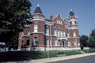
Matthew Hillsman "Red" Taylor was an attorney and politician, serving as a state representative and Speaker of the House in Tennessee. He played college football at Vanderbilt University. He later became a prominent attorney in St. Louis, Missouri and Memphis, Tennessee. His children included Peter Matthew Hillsman Taylor, who became a Pulitzer Prize-winning author.

References

  1. "National Natural Landmarks - National Natural Landmarks (U.S. National Park Service)". www.nps.gov. Retrieved 2019-03-28. Year designated: 1966
  2. US Geological Survey. "Summary of 1811-1812 New Madrid Earthquakes Sequence". USGS. Retrieved 8 August 2017.
  3. Stahle, David W.; VanArsdale, Roy B.; Cleaveland, Malcolm K. (1 July 1992). "Tectonic Signal in Baldcypress Trees at Reelfoot Lake, Tennessee". Seismological Research Letters. 63 (3): 439–447. doi:10.1785/gssrl.63.3.439.
  4. Jedidiah Morse (1797). The American Gazetteer. At the Presses of S. Hall, and Thomas & Andrews, and sold by E. Larkin, and the other booksellers in Boston; by Gaine & Ten Eyck, and S. Campbell, New-York. p. 308.
  5. "New Madrid Compendium Eyewitness Accounts". www.memphis.edu. Retrieved 3 August 2018.
  6. Williams, Samuel Cole (1930). Beginnings of West Tennessee, in the land of the Chickasaws, 1541-1841. The Watauga Press, Johnson City, Tenn. p. 79. Retrieved 1 August 2018.
  7. Morris, Eastin (1834). The Tennessee Gazetteer, Or Topographical Dictionary. W.H. Hunt & Company. pp. 138, 177.
  8. Lawrence, William L.; Mainfort, Robert C. (1993). "Excavations at 40Lk1, A Mississippian Substructural Mound in the Reelfoot Basin, Lake County, Tennessee". Midcontinental Journal of Archaeology. 18 (1): 18–34. JSTOR   20708340.
  9. Mainfort, Robert C. (1996). "Late Period Chronology in the Central Mississippi Valley: A Western Tennessee Perspective". Southeastern Archaeology. 15 (2): 172–181. JSTOR   40713075.
  10. Jillson, Willard Rouse (1921). The Discovery of Kentucky. Kentucky State Historical Society. p. 122.
  11. Smith, Gerald P.; Evans, E. R. (1 September 1987). "Archaeological Investigations of the Tiptonville Levee Project Area along Old Graveyard Slough in Lake County, Tennessee" (PDF): 13–14. Archived (PDF) from the original on July 27, 2018. Retrieved 2 August 2018.{{cite journal}}: Cite journal requires |journal= (help)
  12. 1 2 3 4 5 6 7 8 9 "Historical Maps of Tennessee: Before 1825". alabamamaps.ua.edu. Retrieved 31 July 2018.
  13. "MAP of the SOUTHERN STATES of AMERICA, Comprehending MARYLAND, VIRGINIA, KENTUCKY, TERRITORY Sth of the OHIO, NORTH CAROLINA, TENNESSEE GOVERNMT, SOUTH CAROLINA, & GEORGIA By J. Russell". National Museum of American History. Retrieved 31 July 2018.
  14. "Historical Maps of Tennessee: 1825-1850". alabamamaps.ua.edu. Retrieved 31 July 2018.
  15. "Historical Maps of Tennessee:1851-1900". alabamamaps.ua.edu. Retrieved 31 July 2018.
  16. Wilbur A. Nelson: "Reelfoot — an Earthquake Lake" in National Geographic Magazine, Vol. XLV, January 1962, p. 103.
  17. Irvin Shrewsbury Cobb (1918). The Works of Irvin S. Cobb: The Escape of Mr. Trimm. The Review of Reviews Corporation. pp. 242–257.
  18. Grove, p. 14
  19. 1 2 3 Jama McMurtery Grove, "Uneasy Waters: The Night Riders at Reelfoot Lake, Tennessee, 1908"], East Tennessee University; Electronic Theses and Dissertations. Paper 1496. http://dc.etsu.edu etd/1496
  20. Special to The New York Times. (1908-10-21). "Night Riders Slay Lawyers". New York Times. Retrieved 2011-12-16.
  21. "Night Riders Slay Lawyers". The Bee (Earlington KY). 1908-10-22. p. 1. Retrieved 2012-02-08.
  22. "Lawyer Escapes Mob". The Bee (Earlington KY). 1908-10-22. p. 1. Retrieved 2012-02-08.
  23. Paul J. Vanderwood: Night Riders of Reelfoot Lake, Memphis State University Press, Memphis, Tennessee: Memphis State University Press, 1969
  24. Vanderwood (1969), Night Riders, pp. 9, 11-12, 144-147
  25. Jim Johnson, Rivers under Siege: The Troubled Saga of West Tennessee's Wetlands, Knoxville: University of Tennessee Press, 2007, p. 90
  26. Gordon, Susan. "Tennessee Outdoors". sharetngov.tnsosfiles.com. Retrieved 4 August 2018.
  27. "U.S. Marshals". Usmarshals.warnerbros.com. Archived from the original on 2012-01-14. Retrieved 2011-12-16.
  1. Woody, Larry. "Reelfoot Lake teems with life ... and ghosts". The Tennessean. Retrieved 12 August 2018.