| Regions, municipalities and wards of Trinidad and Tobago | |
|---|---|
 | |
| Location | Trinidad and Tobago |
| Created |
|
| Number | 15 |
 |
|---|
Trinidad and Tobago is divided into seven regions, five boroughs, two city corporations and one ward.
| Regions, municipalities and wards of Trinidad and Tobago | |
|---|---|
| | |
| Location | Trinidad and Tobago |
| Created |
|
| Number | 15 |
| |
|---|
Trinidad and Tobago is divided into seven regions, five boroughs, two city corporations and one ward.
The following are the municipalities and regions created after the amendment of Act No.8 of 1992: [1] [2]
| Municipalities of Trinidad | ||||||
|---|---|---|---|---|---|---|
| Municipality | Status | Land area [3] | Population (2011) [4] | Population density [3] | ||
| km2 | sq mi | /km2 | /sq mi | |||
| Port of Spain | City | 12 | 4.6 | 37,074 | 3,090 | 8,000 |
| San Fernando | City | 19 | 7.3 | 48,838 | 2,570 | 6,700 |
| Chaguanas | Borough | 59 | 23 | 83,516 | 1,416 | 3,670 |
| Arima | Borough | 12 | 4.6 | 33,606 | 2,801 | 7,250 |
| Point Fortin | Borough | 25 | 9.7 | 20,235 | 809 | 2,100 |
| Diego Martin | Borough | 126 | 49 | 102,957 | 817 | 2,120 |
| Siparia | Borough | 495 | 191 | 86,949 | 176 | 460 |
| Regions of Trinidad | ||||||
|---|---|---|---|---|---|---|
| Region | Land area [3] | Population (2011) [5] | Population density [3] | Regional Capital | ||
| km2 | sq mi | /km2 | /sq mi | |||
| Couva–Tabaquite–Talparo | 723 | 279 | 178,410 | 247 | 640 | Couva |
| Mayaro–Rio Claro | 814 | 314 | 35,650 | 44 | 110 | Rio Claro |
| Penal–Debe | 246 | 95 | 89,392 | 363 | 940 | Penal |
| Princes Town | 620 | 240 | 102,375 | 165 | 430 | Princes Town |
| San Juan–Laventille | 239 | 92 | 157,258 | 658 | 1,700 | San Juan |
| Sangre Grande | 927 | 358 | 75,766 | 82 | 210 | Sangre Grande |
| Tunapuna–Piarco | 510 | 200 | 215,119 | 422 | 1,090 | Tunapuna |
The following regions were merged after the amendment of Act No.8 of 1992: [2]
| Dissolved Regions | Consolidated Region |
|---|---|
| Couva | Couva–Tabaquite–Talparo |
| Tabaquite–Talparo | |
| Mayaro | Mayaro–Rio Claro |
| Rio Claro | |
| Tunapuna | Tunapuna–Piarco |
| Piarco | |
| San Juan | San Juan–Laventille |
| Laventille |
Before 1990 Trinidad was divided into eight counties.
Tobago is a ward of Trinidad and Tobago and is governed locally by the Tobago House of Assembly.
Historically, Tobago was divided into seven parishes (Saint Andrew, Saint David, Saint George, Saint John, Saint Mary, Saint Patrick and Saint Paul). In 1768 each parish of Tobago had nominated representatives to the Tobago House of Assembly. On 20 October 1889 the British crown implemented a Royal Order in Council constituting Tobago as a ward of Trinidad, thus terminating local government on Tobago and formed a unified colony government.
In 1945 when the county council system was first introduced, Tobago was administered as a single county of Trinidad.
In 1980 provisions were made for the Tobago House of Assembly to be revived as an entity providing local government in Tobago. Under the revived system, Tobago is made up of 15 local electoral districts since 2021, previously 12 districts, with each district electing one Assemblyman to the THA.
| No. | Electoral districts [6] |
|---|---|
| 1 | Bagatelle/Bacolet |
| 2 | Belle Garden/Glamorgan |
| 3 | Bethel/New Grange |
| 4 | Bethesda/Les Coteaux |
| 5 | Bon Accord/Crown Point |
| 6 | Buccoo/Mt. Pleasant |
| 7 | Darrel Spring/Whim |
| 8 | Lambeau/ Lowlands |
| 9 | Mason Hall/Moriah |
| 10 | Mt. St. George/Goodwood |
| 11 | Parlatuvier/L’Anse Fourmi/Speyside |
| 12 | Plymouth/Black Rock |
| 13 | Roxborough/Argyle |
| 14 | Scarborough/Mt. Grace |
| 15 | Signal Hill/Patience Hill |

This article is about the demography of the population of Trinidad and Tobago including population density, ethnicity, education level, health of the populace, economic status, religious affiliations and other aspects of the population.

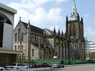
Port of Spain, officially the City of Port of Spain, is the capital of Trinidad and Tobago and the third largest municipality, after Chaguanas and San Fernando. The city has a municipal population of 49,031, an urban population of 544,949 and a transient daily population of 250,000. It is located on the Gulf of Paria, on the northwest coast of the island of Trinidad and is part of a larger conurbation stretching from Chaguaramas in the west to Arima in the east with an estimated population of 600,000.

Tobago is an island and ward within the Republic of Trinidad and Tobago. It is located 35 kilometres (22 mi) northeast of the larger island of Trinidad and about 160 kilometres (99 mi) off the northeastern coast of Venezuela. It also lies to the southeast of Grenada.

Trinidad is the larger and more populous of the two major islands of Trinidad and Tobago. The island lies 11 km (6.8 mi) off the northeastern coast of Venezuela and sits on the continental shelf of South America. It is often referred to as the southernmost island in the West Indies. With an area of 4,768 km2 (1,841 sq mi), it is also the fifth largest in the West Indies.
Afro-Trinidadians and Tobagonians are people from Trinidad and Tobago who are of Sub-Saharan African descent, mostly from West Africa. Social interpretations of race in Trinidad and Tobago are often used to dictate who is of West African descent. Mulatto-Creole, Dougla, Blasian, Zambo, Maroon, Pardo, Quadroon, Octoroon or Hexadecaroon (Quintroon) were all racial terms used to measure the amount of West African ancestry someone possessed in Trinidad and Tobago and throughout North American, Latin American and Caribbean history.

Hinduism is the leading single religion of the Indo-Caribbean communities of the West Indies. Hindus are particularly well represented in Guyana, Suriname and Trinidad and Tobago. The Cayman Islands also hosts a sizable Hindu population, with 2.4 percent of the country affiliating with the religion. Smaller groups of Indo-Caribbeans live elsewhere in the Caribbean, especially Puerto Rico, Jamaica, Belize, Barbados, Saint Vincent and the Grenadines, Saint Lucia, and Bahamas.
Christianity is the largest religion in Trinidad and Tobago, with significant minorities of the adherents of Hinduism and Islam.

The island nation of Saint Lucia is divided into 10 districts. The name Quarters or Quartiers originally came from the French period in Saint Lucia. The 2001 and 2010 Census of Saint Lucia refers to the first level administrative divisions as districts. The FIPS and ISO standards regularly called these divisions quarters or quartiers in French. The former district of Dauphin Quarter was merged into Gros Islet District and the former district of Praslin Quarter was merged into Micoud District.

The counties of Trinidad and Tobago are historic administrative divisions of Trinidad and Tobago. Trinidad was divided into eight counties, and these counties were subdivided into wards. Tobago was administered as a ward of Saint David County.

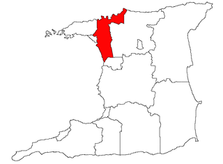
Couva–Tabaquite–Talparo is one of the nine regions of Trinidad and Tobago, and one of the five regions which form the Gulf of Paria coastline on Trinidad's West Coast. Its regional capital and commercial center is Couva. Couva–Tabaquite–Talparo is the third-largest of Trinidad and Tobago's nine regions, with an area of 723 square kilometres (300 sq mi). As of 2011, the population was 178,410. The region is the second-most populous and fourth-least-densely populated region in Trinidad with 247 inhabitants per square kilometre (640/sq mi).

Penal–Debe region is a region of Trinidad. The local government body is Penal–Debe Regional Corporation, a Regional Corporation of Trinidad and Tobago. The region has a land area of 246.91 km². Urban areas within Penal–Debe include Penal, where the corporation is headquartered, and Debe. Indians make up the majority of the region with 71%, followed by minorities of Africans, Douglas, other multiracial, Europeans, Chinese, Amerindians, Portuguese, Arabs, and others. Hinduism is the largest religion in the region at 43%, followed by Christianity, Islam, not stated, others, Irreligion, Orisha-Shango, and Rastafari.
San Juan–Laventille is a region of Trinidad. It has a land area of 220.39 km². The San Juan–Laventille Regional Corporation is headquartered at MTS Plaza in Aranguez, San Juan. Other urban areas include Barataria, Laventille, Morvant and San Juan. It is the smallest region in Trinidad. The region is bordered by Port of Spain in the west to St. Joseph in the east.

Sangre Grande is a region of Trinidad. The Region of Sangre Grande is a local government body and the largest Region of Trinidad and Tobago by area. The region has a land area of 898.94 km². The Sangre Grande Regional Corporation is headquartered in Sangre Grande. Other urban areas within include Guaico, Toco and Valencia. For the Council Term of 2013–2016 the Sangre Grande Regional Corporation was expanded to include one additional Electoral District.

Tunapuna–Piarco is one of the 9 regions of Trinidad and Tobago. It is the most populous region in the country by total population and the fifth-largest by total land area. Geographically located in Northern Trinidad, Tunapuna–Piarco shares its borders with the regions of San Juan–Laventille to the west, Couva–Tabaquite–Talparo to the south, the Borough of Chaguanas to the south-west, Sangre Grande to the east and the Caribbean Sea to the north. The region also completely surrounds the Royal Chartered Borough of Arima, which is located in the south-eastern corner of the region.

Papua New Guinea has 326 local-level governments (LLGs) comprising 6,112 wards as of 2018.

The regions, formerly known as the government office regions, are the highest tier of sub-national division in England. They were established in 1994 and follow the 1974–96 county borders. They are a continuation of the former 1940s standard regions which followed the 1889–1974 administrative county borders. Between 1994 and 2011, all nine regions had partly devolved functions; they no longer fulfil this role, continuing to be used for limited statistical purposes.

The bilateral relations between the Republic of India and the Republic of Trinidad and Tobago have considerably expanded in recent years with both nations building strategic and commercial ties. Both nations formally established diplomatic relations in 1962. Indo-Trinidadian and Tobagonians form the largest ethnic group in the country at 37.6% of the total population.

Trinidadians and Tobagonians, colloquially known as Trinis or Trinbagonians, are the people who are identified with the country of Trinidad and Tobago. The country is home to people of many different national, ethnic and religious origins. As a result, Trinidadians do not equate their nationality with race and ethnicity, but with citizenship, identification with the islands as whole, or either Trinidad or Tobago specifically. Although citizens make up the majority of Trinidadians, there is a substantial number of Trinidadian expatriates, dual citizens and descendants living worldwide, chiefly elsewhere in the Anglosphere.
The Southern Region has been a region in Ireland since 1 January 2015. It is a NUTS Level II statistical region of Ireland.
| Regions | |
|---|---|
| Municipalities | |
| Other bodies | |
| Counties (historic) | |
