
Reisterstown is an unincorporated community and census-designated place in Baltimore County, Maryland, United States. As of the 2010 census, it had a population of 25,968.
Oella is a mill town on the Patapsco River in western Baltimore County, Maryland, United States, located between Catonsville and Ellicott City. It is a 19th-century village of millworkers' homes.

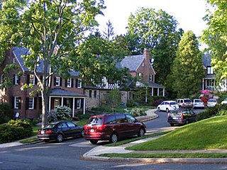
Mount Washington is an area of northwest Baltimore, Maryland. It is a designated city historic district and divided into two sections: South Road/Sulgrave to the southeast and Dixon's Hill to the north. The Mount Washington Historic District was listed on the National Register of Historic Places in 1990 with a boundary increase in 2001, with five contributing buildings and four contributing structures.

Calvert Hills Historic District is a national historic district in College Park, Prince George's County, Maryland. It is roughly bounded on the north by Calvert Road, on the east by the Green Line metrorail corridor, on the south by the northern boundary of Riverdale Park, and on the west by Baltimore Avenue. It does not include Calvert Park on the southeast corner. Primarily a middle-class single-family residential neighborhood, it also includes some apartment houses as well as the College Park Post Office, a contributing property at 4815 Calvert Road.

The Inns on the National Road is a national historic district near Cumberland, Allegany County, Maryland. It originally consisted of 11 Maryland inns on the National Road and located in Allegany and Garrett counties. Those that remain stand as the physical remains of the almost-legendary hospitality offered on this well-traveled route to the west.

Brooklandville House, or the Valley Inn, is a historic restaurant and tavern building, and a former inn, located in Brooklandville, Baltimore County, Maryland. It is a 2+1⁄2-story stone structure facing the former railroad and dating from about 1832. It is associated with the Baltimore and Susquehanna Railroad, which crossed the property just to the south.
Montrose Mansion and Chapel, originally known as Montrose Mansion, is a historic home located on the campus of Camp Fretterd Military Reservation of the Maryland Army National Guard in Reisterstown, Baltimore County, Maryland. It is a two-story neoclassical stone house constructed originally about 1826 by William Patterson who gave it to his grandson, Jerome Napoleon Bonaparte as a wedding present. By the middle of the 19th century, a large two-story wing was added, then a mansard roof with round-top dormers, a cupola, and a bracketed cornice with pendants was added about 1880. The chapel was completed in 1855 and is a rectangular structure of stone with Greek Revival decorative detailing. It features a three-story bell and entrance tower.

St. Michael's Church, also known as St. Michael's Chapel and Hannah More Chapel, is a historic Episcopal Church located at Academy Lane and Reisterstown Road in Reisterstown, Baltimore County, Maryland. It is a small, Carpenter Gothic-style, board and batten frame structure, featuring a simple bell-gable. It was designed by New York architect John W. Priest (1825-1859), and constructed about 1853. It was named after Hannah More. It was deconsecrated on May 12, 1978.

Johnsville is an unincorporated community in Frederick County, Maryland, United States. It is located approximately halfway between Libertytown and Union Bridge along Maryland Route 75. The Kitterman-Buckey Farm was listed on the National Register of Historic Places in 2005.
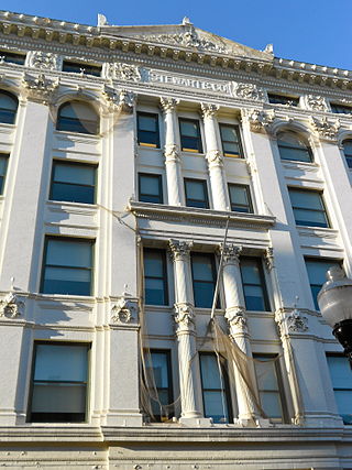
Stewart's Department Store, also known as the Posner Building, is a historic department store building located on Howard Street at Baltimore, Maryland, United States. Catholic Relief Services is currently headquartered there.

Louisa May Alcott School, also known as "School No. 59" and "Reisterstown Road School," is a historic elementary school located at Baltimore, Maryland, United States. It is a Colonial Revival or Georgian Revival structure completed in 1910. The freestanding building rises 3 ½ to 4 levels from brick base to metal cornice. It features symmetrically designed brick and stucco bands, decorative terra cotta, and three metal cupolas atop the hipped roof.
Dundalk Historic District is a national historic district in Baltimore, and Baltimore County, Maryland, United States. The district is a cohesive unit made up of residential, commercial, and institutional buildings with structures that generally date from 1910 to 1940. Major architectural styles represented include Period Revival and Art Deco/Streamline Moderne. The District includes 962 resources contribute to its significance. It includes the only two housing developments built by the United States Shipping Board Merchant Fleet Corporation (EFC) in Maryland during World War I and reflects experimentation with Garden City planning ideals. Many of the buildings within the District represent the work of noted Baltimore architect Edward L. Palmer, Jr.

Glyndon Historic District is a national historic district in Glyndon, Baltimore County, Maryland, United States. It is a turn-of-the-20th-century community northeast of Reisterstown, Maryland, that began as a summer resort. The district is residential except for a small business district located at the intersection of Butler Road and the Western Maryland Railway tracks. The Emory Grove Campground on the northern boundary is occupied in the summer. A decided architectural homogeneity exists in Glyndon representing vernacular examples of late 19th century styles. They are typically frame, 2+1⁄2-story-high cottages, with one or occasionally 2-story front porches.

Granite Historic District is a national historic district in Granite, Baltimore County, Maryland, United States. It comprises the focus of a rural quarrying community located in the Patapsco Valley of western Baltimore County, Maryland. It includes two churches, a school, a social hall, former commercial buildings, and houses and outbuildings, representing the period from the initial settlement of the area about 1750 through the early 20th century, when the village achieved its present form. The district also includes the former Waltersville quarry, one of two major granite operations in the region during the period. Granite from the Waltersville and Fox Rock quarries was utilized in construction of the Baltimore & Ohio Railroad in the 1830s, and later in such projects as the Library of Congress, old Treasury Building, and parts of the inner walls of the Washington Monument in Washington, D.C., and numerous other projects in Baltimore city and county.
Corbett Historic District is a national historic district at Monkton, Baltimore County, Maryland, United States. It is a group of 20 dwellings, a doctor's office, a former store/post office, a brothel, and a school comprising the village of Corbett in rural northern Baltimore County, Maryland. Most of the buildings date from about 1880 through about 1920. They reflect the period of Corbett's development as a stop on the Northern Central Railway, and a local commercial, industrial, and transportation center for the surrounding farms.
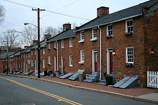
Ellicott's Mills Historic District is a national historic district at Oella, Baltimore County, Maryland, United States. It is on the east bank of the Patapsco River, opposite Ellicott City. This historic district designation relates to the industrial operations of the Ellicott family from the 1770s through the mid-19th century. It consists of the sites of historic buildings including: an 18th-century building, a section of an 18th-century mill incorporated in a 20th-century factory, a 19th-century tavern, 19th-century workers housing, and an 1859 Italianate villa built by John Ellicott. Historically, these industrious mills were served by the major east–west route in Maryland during the early 19th century, the old National Pike. Also in the district is the mammoth multi-story Wilkins-Rogers Company flour plant, which is located on the site of the 1792 Ellicott Flour Mill, the first merchant flour mill in the United States.

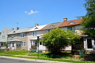
Lutherville Historic District is a national historic district in Lutherville, Baltimore County, Maryland, United States. It is an irregularly shaped urban entity founded in 1852 as a summer resort and suburb of Baltimore City. Single-family dwellings on large lots characterize the community and most of the structures predate World War I, although ranch-type and "colonial" houses have appeared in the past few decades.

Worthington Valley Historic District is a national historic district in Reisterstown, Baltimore County, Maryland, United States. It is a largely rural district where the earliest standing structures date from the very end of the 18th century. Horse breeding and racing is a very large and lucrative business in the valley. Since 1922, Snow Hill and Worthington Farms have been the scene of the Maryland Hunt Cup Steeplechase. Located next to it is the Western Run–Belfast Road Historic District.
Tuscany-Canterbury is a historic neighborhood in northern Baltimore, Maryland, United States. Its history, development, and flavor are outlined in Eileen Higham's book Tuscany-Canterbury: A Baltimore Neighborhood History.
The Auchentoroloy Terrace Historic District encompasses a residential district southwest of Druid Hill Park on the northwest side of Baltimore, Maryland. It is roughly bounded by Auchentoroly Terrace, Reisterstown Road, Liberty Heights Avenue, and Fulton Avenue. This area was developed between 1895 and 1911 with a series of large, fashionable townhouses, mainly in the Renaissance Revival style. Development was begun by the heirs of John Morris Orem, and largely finished by the Auchentoroloy Corporation, which acquired land not developed by the Orems.


